Climate Notes September/October 2008:
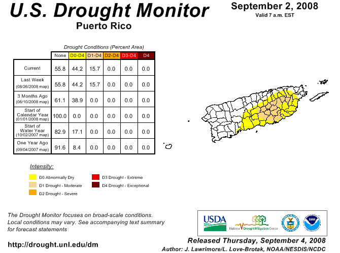
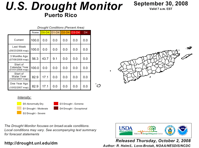
At the end of August 2008, Puerto Rico had received only 79% of its average rainfall over the first eight months of the year. This deficit of rainfall was evident in the U.S. Drought Monitors September 2 nd, 2008 assessment for Puerto Rico, which classified large sections of the island as being abnormally dry, and further classified portions of the eastern interior and southern slopes as being in a moderate drought (see graphic below). However, by the end of September 2008, Puerto Rico had made up this deficit and finished the month of September with 105% of its normal rainfall year to date (YTD), marking the first time since February 9 th, 2008 that YTD rainfall across Puerto Rico was above normal. This was in large part thanks to two significant weather events that brought torrential rains to the island during the month of September: (1) the weather associated with the outer bands of Tropical Storm Hanna and (2) the weather associated with a strong tropical wave that later became Tropical storm Kyle. Thanks to the record rainfall associated with these two events, by the end of September, the U.S. Drought Monitor graphic of Puerto Rico indicated that no section of the island was experiencing abnormally dry or drought conditions (see graphic below or the drought monitor archive to access weekly assessments).
September marks the peak of hurricane season for Puerto Rico and not surprisingly, September is also the wettest month of the year. On average, 9.23” of rainfall accumulates across the island during the month of September, with a total of 19.18” accumulating in September 2008. Up to 30 inches of rainfall fell over sections of the island during the September 21 st – 23 rd time period alone. At the Luis Muñoz International Airport in San Juan, where official records are kept, 5.58” of rain normally falls in the month of September, with 9.93” of rain falling this year, an excess of nearly four and a half inches. The wettest September on record was September 1996, when 15.15” of rain fell in San Juan, and the driest September on record was September 1987, when only 1.73” of rainfall was recorded in San Juan. Temperatures in San Juan averaged 82.6ºF, which was 0.1ºF warmer than the 52 year average for the month, making September the fifth consecutive above normal month, in terms of temperature, across San Juan.
Some of the most extreme rainfall totals for the month of September fell over a 24 hour period beginning at 8 am September 21 st, 2008 and ending at 8 am September 22 nd, 2008. Some of the measured rainfall totals for this 24 hour period included 22.03” in Patillas, 20.00” in Guayama, 16.00” in Cabo Rojo, 14.83” in Yabucoa, and 10.81” in Ponce. Due to periods of very heavy rainfall observed during the month of September, a total of 25 flood warnings and 53 flash flood warnings were issued by the National Weather Service in San Juan to cover widespread areas of flooding across the island. Maximum temperatures for the month ranged from 94ºF in Gurabo on the 18 th, 94ºF in San Juan on the 26 th, 93ºF at Dos Bocas on the 6 th, 93ºF in Corozal on the 10 th, and 93ºF in Central Aguirre on the 19 th. Minimum temperatures fell to 57ºF in Adjuntas on the 11 th, 58ºF in Central Aguirre on the 24 th, and 59ºF in Cerro Maravilla on the 23 rd.
Looking ahead, the month of October is the second wettest month of the year across Puerto Rico, and October is the 3 rd wettest month of the year in San Juan (an average of 5.65” of rain falls at the Luis Muñoz International Airport in San Juan each September). The wettest October on record, was October 1970, when 15.06” of rain fell in San Juan and the driest October on record was October 1979, when only 1.17” of rainfall was recorded. The mean temperature at the Luis Muñoz International Airport in San Juan for October is 81.8ºF*, making October the 5 th warmest month of the year. While the peak of hurricane season has passed, the August 2008 outlook for the remainder of the 2008 Atlantic hurricane season continues to indicate a 95% chance of a normal or above normal hurricane season which ends on November 30 th. This outlook is based on lingering La Niña conditions and multi-decadal conditions, which will likely make 2008 the10 th Atlantic hurricane season since 1995 with above normal activity. The official discussion from the climate prediction center can be viewed at: http://www.cpc.noaa.gov/products/outlooks/hurricane.shtml
* All climate averages for San Juan taken from 52 continuous year period of 1956-2007 which differ from the 30-year average used in official climate reports *

|

 National Weather Service Forecast Office