Skip Navigation Linksweather.gov 
Go
to NOAA's main pageGo to the NWS main page National Weather Service Forecast Office
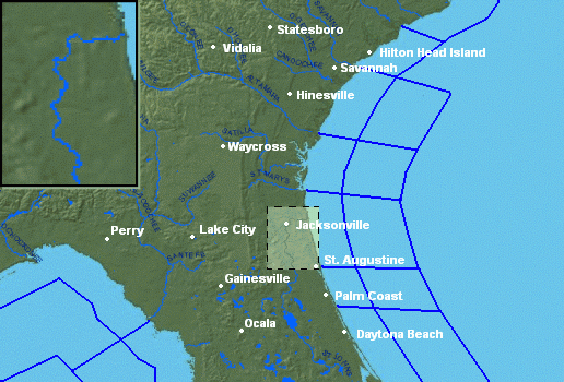
Jacksonville, FL

NWS Jacksonville Home » Marine Weather
 Marine Conditions & Tide Map help
Marine Data Map
Palatka Tides
Palmetto Bluff Tides
Green Cove Springs Tides
Black Creek RR Bridge Tides
Julington Creek Tides
Orange Park Landing Tides
Piney Point Tides
Piney Point Tides
Piney Point Tides
Piney Point Tides
Piney Point Tides
Piney Point Tides
Piney Point Tides
Piney Point Tides
Dames Point Tides
Sisters Creek Tides
Mayport Tides
Pablo Creek ICWW Bridge Tides
Nassau River at Halfmoon Island Tides
Nassau River at Mink Creek Tides
Nassau River at Lofton Creek Tides
Nassau River at Tiger Point Tides
Fernandina Beach Tides
South Amelia River at Amelia City Tides
Nassau River Entrance Tides
Little Talbot Island Tides
Atlantic Beach Tides
Jacksonville Beach Tides
Oak Landing Tides
Palm Valley Tides
Vilano Beach Tides
Saint Augustine Tides
Saint Augustine Beach Tides
Smith Creek at Flagler Beach Tides
Halifax River at Ormond Beach Tides
Daytona Beach Shores Tides
Savannah River Entrance Tides
Saint Simons Island Light Tides
St Marys Entrance Tides
Kings Bay Navy Base Tides
Cumberland Island Tides
Withlacoochee River Entrance Tides
Cedar Key Tides
Suwannee River Entrance Tides
Pepperfish Keys Tides
Deadman Bay Tides
Deadman Bay Tides
Spring Warrior Creek Tides
Rock Islands Tides
Aucilla River Entrance Tides
St Marks River Entrance Tides
tide icon Tides
Arlington, FL
Mayport, FL
Orange Park, FL
St. Augustine, FL
Daytona Beach, FL
Perry, FL
Cross City, FL
Bunnell, FL
St. Simons Is., GA
Fort Stewart, GA
Savannah, GA
Brunswick, GA
Keaton Beach C-MAN
Shell Point COMPS
Edisto Buoy
Grays Reef Buoy
Fripp Nearshore Buoy
Sapelo Is NERRS
Skidaway M2R6 Buoy
Ft. Pulaski NOS
Fernandina Bch NOS
Guana Tolomato NERRS
St. Augustine Buoy
Fernandina Buoy
St. Augustine C-MAN
Canaveral Buoy 41113
Canaveral Buoy 41009
Canaveral Buoy 41010
metar icon Land Obs
buoy/c-man icon Buoy/C-MAN Obs
Conditions at 11 AM
Conditions at 11 AM
Interactive Buoy Maps: Florida & E Gulf / Mid-Atlantic / W Gulf / Global
 Area Marine ObservationsUpdated at 11:14 AM EDT 
LocationIDOb
Time
Wind
(kts)
Wave Ht
(ft)
Wave Per
(sec)
Air
Tmp
Water
Tmp
 Cedar Key (C-MAN) CDRF110 AM S 7-9 76
 Keaton Beach (C-MAN) KTNF111 AM S 8-9 75
 Shell Point Tower SHPF110 AM S 5-7 76
 West Tampa (buoy) 4203611 AM S 10-10 1 6 75 76
 Edisto (buoy) 4100410 AM SW 10-12 5 8 74 73
 Grays Reef (buoy) 4100811 AM SW 10-12 310 75
 Fripp Nearshore (buoy) 4103310 AM SW 8 73
 Sapelo Island (NERRS) SAXG110 AM SW 6 77
 Skidaway M2R6 Tower SKMG111 AM S 10-12 72
 Ft Pulaski (NOS) FPKG110 AM S 6-7 78 76
 Fernandina Bch (NOS) FRDF111 AM SW 5-6 78 78
 Guana Tolomato (NERRS) GTXF110 AM NW 2 80
 St. Augustine (buoy) 4101211 AM SW 8-10 3 9 73
 St Marys (buoy) 4111210 AM 310 70
 St Augustine (C-MAN) SAUF111 AM E 4-4 76 72
 Trident Pier (NOS) TRDF111 AM S 6-9 78 72
 Canaveral Nearshore (buoy) 4111310 AM 2 9 70
 Canaveral West (buoy) 4100911 AM S 12-16 4 9 77 78
 Canaveral East (buoy) 4101011 AM S 6-8 4 9 77 79
Click variable for 5-day graph • Interactive Buoy Maps:  Florida & E Gulf / Mid-Atlantic / W Gulf / Global

 Tide Predictions   (U.S. Tides)  info
 
 Mayport
 St. Augustine
 St. Simons Is.
 Cedar Key
Fri
8th
L2:35 AM-0.3 ft 
H8:51 AM4.3 ft 
L2:30 PM-0.4 ft 
H9:19 PM5.2 ft 
L2:52 AM0.2 ft 
H8:39 AM4.7 ft 
L2:50 PM0.1 ft 
H9:09 PM5.6 ft 
L2:41 AM-0.1 ft 
H8:21 AM6.5 ft 
L2:41 PM-0.1 ft 
H8:52 PM7.6 ft 
H2:27 AM3.3 ft 
L7:53 AM1.2 ft 
H1:34 PM4.1 ft 
L8:42 PM-0.5 ft 
Sat
9th
L3:18 AM-0.3 ft 
H9:32 AM4.2 ft 
L3:09 PM-0.3 ft 
H9:58 PM5.0 ft 
graph more audio
L3:36 AM0.2 ft 
H9:22 AM4.6 ft 
L3:31 PM0.2 ft 
H9:50 PM5.5 ft 
graph more audio
L3:26 AM-0.1 ft 
H9:03 AM6.4 ft 
L3:22 PM0.1 ft 
H9:31 PM7.4 ft 
graph more audio
H3:07 AM3.3 ft 
L8:26 AM1.4 ft 
H2:04 PM4.1 ft 
L9:17 PM-0.5 ft 
graph more audio
Table
Graph

 Sun & Moon Information  more info
 
Frisunrise
sunset
Satsunrise
sunset
 
Jacksonville
6:37 AM
8:09 PM
6:37 AM
8:10 PM
2009 2010 audio
Gainesville
6:41 AM
8:11 PM
6:40 AM
8:12 PM
2009 2010 audio
Ocala
6:41 AM
8:09 PM
6:40 AM
8:10 PM
2009 2010 audio
Alma
6:39 AM
8:15 PM
6:38 AM
8:16 PM
2009 2010 audio
St. Simons
6:35 AM
8:10 PM
6:34 AM
8:11 PM
2009 2010 audio
Moon
Full moon May 8
Last quarter moon May 17
New moon May 24
First quarter moon May 30
2009 2010 audio

 Other Offshore Marine Observations & Sea Surface Temperatures (SST)
 Local Marine Reports Local Ship Reports Skidaway Institute Buoys
 NOS Marine Obs: FLGA Fernandina Buoy: Wave Temp Nat'l Data Buoy Center
SST Analyses: FL CoastRegional w/ contoursN AtlanticS AtlanticGulf of Mexico
Average Surf Temperatures:  AtlanticGulf of Mexico
Gulf of Mexico/W Atlantic Analyses:         [Key]
 Marine Forecast Products
Text Clickable Maps
 Offshore Forecast (SW N Atlantic/Caribbean)
 Offshore Forecast (Gulf of Mexico)
 Offshore Forecast (Mid-Atlantic)
 High Seas Forecast (Atlantic)
 US Coastal Waters Forecasts
 US Offshore Marine Forecasts
 US High Seas Marine Forecasts
 Wave Model Forecasts
 Wave Analysis and Forecasts WAM Wind/Seas Loop
 Navy COAMPS Model Data NCEP WaveWatch III Wind/Seas Loop
  JAX SWAN-GFS Model Text
 Other Marine Related Links
NWS Marine Product Dissemination Info
Voluntary Observing Ships Program
Lightning and Boats
Ocean Prediction Center
Marine Weather Glossary
Safe Boating Council
Mariner's Guide to Marine Weather Services:  PDF   TEXT 

Page last modified: May 7, 2009
  weather.gov/jax/marine
  Marine Weather Message product now available.
Info | Product

  The National Weather Service needs your marine weather reports!
To send us a marine weather report, please fill out our online marine weather report form.

  Are you finding the data from the St. Augustine buoy helpful?
If so, we'd love to hear about it.  Email Andrew Shashy, marine focal point.

  Questions or comments about the NWS Jacksonville marine program?
Email Andrew Shashy, marine focal point.

 Beaufort Wind Scale
Force Wind
(kts)
Classification
0 < 1 Calm
1 1-3 Light Air
2 4-6 Light Breeze
3 7-10 Gentle Breeze
4 11-16 Moderate Breeze
5 17-21 Fresh Breeze
6 22-27 Strong Breeze
7 28-33 Near Gale
8 34-40 Gale
9 41-47 Strong Gale
10 48-55 Storm
11 56-63 Violent Storm
12 63 > Hurricane
Complete Chart
 Unit Conversion
oF =  oC
knots =  mph