
 Feeds & Data
Magnitude 5.1 - IZU ISLANDS, JAPAN REGION
2009 January 15 09:34:45 UTC
Earthquake Details
| Magnitude | 5.1 |
|---|---|
| Date-Time |
|
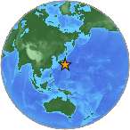
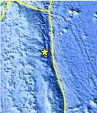
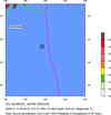
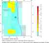
| Location | 31.396°N, 141.663°E |
| Depth | 58.6 km (36.4 miles) |
| Region | IZU ISLANDS, JAPAN REGION |
| Distances | 255 km (160 miles) SE of Hachijo-jima, Izu Islands, Japan 480 km (300 miles) N of Chichi-shima, Bonin Islands, Japan 500 km (310 miles) SE of Shizuoka, Honshu, Japan 505 km (315 miles) SSE of TOKYO, Japan |
| Location Uncertainty | horizontal +/- 9.8 km (6.1 miles); depth +/- 20.4 km (12.7 miles) |
| Parameters | NST= 32, Nph= 32, Dmin=654.7 km, Rmss=1.03 sec, Gp=133°, M-type=body magnitude (Mb), Version=7 |
| Source |
|
| Event ID | us2009bwak |
- This event has been reviewed by a seismologist.
- Did you feel it? Report shaking and damage at your location. You can also view a map displaying accumulated data from your report and others.
Earthquake Maps

Scientific & Technical Information
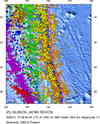
 Historic Moment Tensor Solutions
- Preliminary Earthquake Report
- U.S. Geological Survey, National Earthquake Information Center:
World Data Center for Seismology, Denver
