|
About the Watershed Database and Mapping Projects
Introduction
Protecting and restoring coastal watersheds involves understanding an array of complex environmental issues and synthesizing various kinds of information. Because aquatic ecosystems are affected by so many different characteristics of the watershed, impact assessment and management can be significantly improved by using a method that shows the geographic relationship between measurements taken at specific places and the characteristics specific to that region.
This analysis is made easier by combining scientific data and watershed characteristics into a Geographic Information System (GIS). NOAA's Assessment and Restoration Division has developed numerous Watershed Database and Mapping Projects that combine a standard database structure, database-mapping application (Query Manager), and GIS data. Using these elements, sediment contaminant concentrations, toxicity and tissue data, natural resources, and potential habitat restoration projects can be overlaid on a watershed's features and land uses, and displayed on maps at flexible spatial scales.
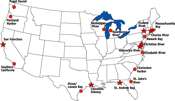
Project Locations
The map below displays many of our watershed database and mapping project locations. Projects with red stars have CD-ROMs available, which include the Query Manager database, MARPLOT mapping application, and an ArcView GIS project where applicable.
More information on Watershed Projects
|
- Query Manager and MARPLOT An introduction to the Query Manager and MARPLOT applications that are used extensively throughout the ARD watershed projects
|
|
|
- ARD GIS Tools Discover the various GIS Tools that have been created to spatially analyze Watershed Project data
|
|
|
|
|
|
|
|
|
List of Available Watershed Projects:
Follow the links below to learn about the various watershed projects, plus the software and data used to help NOAA achieve its goal of protecting trust resources. Each watershed project has unique characteristics and may be comprised of various components, as detailed below. |
|
|
|
|
|
|
|
|
|
|
|
|
|
|
|
|
|
|
|
|
|