|
Are you new to GEO and GEOSS? Find out more here!
Highlights
Bucharest conference sets GEO’s strategy through 2011
This year’s annual meeting of the Group on Earth Observations was held in Bucharest, Romania, on 19-20 November.
The highlight of the meeting was the announcement that the 40-year archive of data and images from the Landsat Earth observation satellites is now freely available to all users without restriction. Landsat constitutes the world’s most extensive collection of continuously-acquired remotely-sensed satellite imagery.
A major purpose of the GEO-V Plenary was to evaluate the substantive work being carried out by the GEO membership. This included the development of the GEOSS Common Infrastructure (consisting of portals, registries and a clearinghouse), the recent launch of the GEO Biodiversity Observation Network, advances on forest monitoring, and other regional and national activities.
As for management issues, the meeting accepted a 2009-2011 Work Plan that details the actions governments and organizations will take to make the Global Earth Observation System of Systems (GEOSS) a reality. The Plan sets out 42 overarching Tasks for guiding the construction of GEOSS from 2009 through 2011. Together, these activities will build the fundamental infrastructure underpinning GEOSS and establish products and services for decision-makers in the fields of climate, biodiversity, agriculture and six other Societal Benefit Areas.
The Work Plan was accepted as a “living document” that will be updated annually. Over the course of the coming year, the GEO community will receive further guidance as the 10-year targets for GEOSS agreed in 2005 are updated and refined. The development of a new “performance and evaluation framework” will provide additional direction. Based on all this work and guidance, Ministers participating in GEO’s 2010 Summit will have the tools and information they need to make a mid-term evaluation of the progress being made on GEOSS.
GEO-V also welcomed four new Member governments – the Bahamas, Estonia, Peru and Turkey – bringing GEO’s total membership to 77. Five new Participating Organizations were accepted into GEO, bringing the total to 56.
The GEO-VI Plenary meeting will be held in Washington DC in late 2009.
AARSE urges African countries to participate in GEO
Participants from 40 countries gathered in Accra from 27-30 October for the 7th International Conference of the African Association of Remote Sensing of the Environment (AARSE). The conference declaration calls for the expanded use of Earth observations in Africa.
 |
|
|

|
Evaluating the GEO Portal prototypes |
|
Components registration |
|
Standards registration |
|
|
|
|
|
The assessment phase for the GEO Portals runs until May 2009. The Portals are updated regularly so please make repeat visits and provide your feedback. |
|
The GEO community is invited to register its data bases, catalogues, services and tools in the GEOSS Components and Services Registry |
|
The GEO community is encouraged to register standards, protocols and other specifications for ensuring an interoperable “system of systems” in the GEOSS Registry |
| |
|
As of Monday, 12 Jan 2009 |
 |
components registered |
 |
services registered |
|
|
|
|
|
|
|
|
JAXA hosts seminar on climate change observation
The 2nd Seminar on Space Based Observations for Climate Change was hosted by the Japan Aerospace Exploration Agency (JAXA) in Tokyo on 18 September. Responding to last July’s G-8 Hokkaido Toyako Summit Declaration, the seminar focused on accelerating GEOSS activities in the priority areas of climate and water-resource management.
It also examined the many important contributions that space agencies are making to GEOSS implementation. The summary report, presentations and other information are posted here.
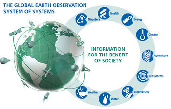
What are GEO and GEOSS?
The Group on Earth Observations (or GEO) is coordinating international efforts to build a Global Earth Observation System of Systems (GEOSS). This emerging public infrastructure is interconnecting a diverse and growing array of instruments and systems for monitoring and forecasting changes in the global environment. This “system of systems” supports policymakers, resource managers, science researchers and many other experts and decision-makers.
Click here to learn more about GEOSS. You can find more details on how GEO functions on the "About GEO pages" and in the GEO Information Kit.
Bangladesh’s Meghna to be model basin for flood forecasting
Dhaka, Aug 11 (IANS) -- Bangladesh is set to evolve a model for forecasting floods and rainfall starting with the Meghna river after which the other river basins of the country would also also be included in the proposed system. The 10-year plan has been initiated with Meghna and the first model is set to be complete by 2011, the Daily Star reported Monday.
Flowing as the Ganga from the Himalayas in India, the river acquires the name Meghna once the Brahmaputra joins it in Bangladesh and is the major river system of the country.
The plan is being initiated in view of looming impact of climate change, under the framework of the Global Earth Observation System of Systems (GEOSS) to improve sustainable water resource management in Bangladesh. Read full article
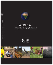
Atlas of Africa’s Changing Environment demonstrates power of Earth observations
The Africa edition of the United Nations Environment Programme's “Atlas of our Changing Environment” highlights how modern Earth observation systems can support action to address humanity’s growing impact on the natural environment.
By comparing satellite images and ground photos of specific locations taken 30 years ago and then again today, the Atlas makes it possible to truly comprehend the decade-scale changes occurring in the African environment.
UNEP has presented the Atlas, which was released on 10 June, as a contribution to the Global Earth Observation System of Systems. For more information and a link to the Atlas, you can open or download the press release.
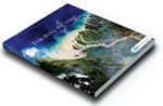
"The Full Picture"
The Full Picture is an exciting
new full-colour publication detailing
selected Early Achievements and
other Earth observation projects
and services. You can download "The
Full Picture" by clicking on
the image on the left.
The First 100 Steps to GEOSS
The Early Achievements that governments
and organizations have contributed
to GEOSS have each been summarized
in a two-page brief and collected
in a document entitled “The First 100 Steps to GEOSS”.
|