
USGS CoreCast
USGS Podcasts Home > CoreCast Home Page
Can't see Flash? Install Flash Player.
|
1
|
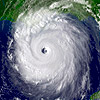
Each year hurricanes and tropical storms cause billions of dollars worth of damage to the Eastern United States. With the peak period being August and September, it's the perfect time to remind ourselves of the risks and discuss what research the USGS does in regard to hurricanes and strong storms.
Type: audio/mpeg
File Size: 11216910 bytes Duration: 11:36 Released: Wed, 22 Aug 2007 15:38:03 UTC |
Transcript:
[music and wind effect fade in, under throughout]
Dave Hebert [voice]
Summer heat getting to you? Then cool off with the USGS and the International Polar Year!
Like a blast of icy-fresh air, the International Polar Year swoops in to blow away the summer blues by
- exploring new frontiers in polar science!
- engaging the public—YES, YOU—in polar discovery!
- and attracting the next generation of earth scientists!
And from permafrost to polar bears, from coastal change to climate change, the USGS is a polar-science powerhouse, with more than 50 years of polar research history.
So let your cooler head prevail—make tracks to www.usgs.gov/ipy, and chill out!
Music credit:
"Carnival Overture, Op. 92" by Antonín Dvořák
[music fades in and then fades out]
Correction: In the following introduction we say that Australia refers to these storms as "typhoons." An Australian listener kindly corrected us in that they are actually referred to as "tropical cyclones."
Steven Sobieszczyk
Hello and welcome. This is the USGS CoreCast, episode 1 for August 2007. I'm Steve Sobieszczyk.
As you may have noticed this is our first foray into the world of podcasting. We figured it was about time we threw out hat into the rink and gave folks a little inside peak into what the USGS is all about. Our goal is to share news, stories, and discussions from around the USGS, examine how our science is serving the Nation, and possibly spotlight some of the more exciting research we do. In this first episode we wanted to focus on something timely, with our first segment of what we expect to be a continuing series, with CoreCast Science Focus: Hurricanes. If you like this first episode, stick around as part of our launch we're giving you a second, bonus episode; but first a look at hurricanes and hurricane research.
Each year, a number of tropical storms and hurricanes batter the eastern U.S. seashore, with Florida, Georgia, and South Carolina typically getting the brunt of it. Although, technically speaking, hurricane season is from June 1st through November 30th, these storms usually form during the summer, with the number of storms peeking in August and September. Therefore, with it being August, we thought it was the right time to remind everyone that there will likely be much more storm activity coming in the next few weeks. After all, each year millions of dollars are spent because of tropical storm and hurricane damage, with the recent Atlantic hurricanes in 2004 and 2005 being the costliest on record.
Hurricanes are revolving tropical storms, with sustained wind speeds exceeding 74 mph. In the U.S. they are referred to as hurricanes, in Asia and Australia the storms are called typhoons, while in India they're called cyclones. There are 5 categories of hurricane, with the category 5 storms being the most dangerous as they have sustained wind speeds greater than 155 mph. Hurricanes and tropical storms have always been destructive to the eastern United States, with 6 of the top 10 costliest U.S. disasters resulting from these type of storms.
To help explain a little bit more about what impact hurricanes have and how the USGS helps in hurricane research, I am proud to be joined by Abby Sallenger, an Oceanographer from the USGS Florida Integrated Science Center in St. Petersburg, Florida. Thanks for joining me, Abby.
Abby
Certainly.
Steve
First off, can you explain what the USGS does regarding hurricane research? It's my understanding that NOAA, the National Oceanic Atmospheric Administration monitors the storms; so what is it the USGS does?
Abby
So as you said NOAA is responsible for coming up with the meteorological information and actually forecasting where the storms are going and their intensity. USGS does get involved more on the impact of what hurricanes do to our coastal areas. So one aspect is something called stream gages, which monitor the elevation of rivers and streams around the country and tropical storms tend to have a lot of rain tied up in them.
The USGS keeps track of the runoff from these storms as they go into the rivers and the rivers rise; and they can look forward towards understanding the floods that come about on rivers from hurricanes. Another aspect is, the USGS with our partners in NASA and the Corps of Engineers fly different kinds of sensors, both before and after hurricanes come ashore on our coastline. And one of these uses a laser to measure the typography or elevation of the coast and by measuring it before and after a storm; we can see how much erosion has occurred. Having airborne systems we can do this quite rapidly. So we can look at hundreds of kilometers of coastline, and how they've changed during a major storm.
Steve
So far this hurricane season seems fairly tame compared, especially to the more intense 2004 and 2005 seasons. What was the original outlook for this season, and has there been any revision to what the hurricane forecast will be for the remainder of the year?
Abby
The long-range forecast for this year did not look particularly good, they looked as if we were going to have a very active season. Around the first part of June, some of the long-range forecast downgraded the season somewhat. The bottom line is, though, everyone should be very wary of what might transpire as we get into August.
Steve
When people think about hurricanes, they tend to think about the destruction that's left in their wake. Every year it seems as if these storms have gotten much worse, much more destructive, with Hurricane Katrina standing out. Is this simply perception or have these recent storms actually progressively gotten worse?
Abby
Well, certainly it is true. Hurricane Katrina was the most destructive storm in United States history by far. What it did to the coastline, what it did to New Orleans, and the people who lived along mainland Mississippi was devastating. But also if you look back into our history you'll see a persistent rise in destruction, a lot of it driven by our rush to move to the coastlines and build densely along our coastlines.
The next storm that comes along exerts a larger toll than even the same size storm from a previous time. But there's no doubt that Katrina, the way to the coast, which it generated one of the largest storm surge or rise in sea level in United States history, was worst on record.
Steve
A lot was made in the news during Hurricane Katrina about the loss in wetlands and barrier islands, and how the reduction of these natural features allowed for the hurricane to retain such high force as it reached landfall. What effect do barrier islands actually have on hurricanes? What about wetlands, are they any more effective at reducing hurricane strength?
Abby
For a long time now, we thought that these natural features offered some protection to the mainland, by reducing storm surges and wave height. That if they weren't there, and the storm was simply attacking as if the cities were at the edge of the ocean that the destruction would be a lot worse. I think in some respects, that's true. But there is a lot of research going on now, particularly after Katrina on the usefulness of barrier islands in cutting down storm surge.
In some of the initial results coming out seems to suggest that barrier islands are not terribly effective in cutting down storm surge. They would, though to some degree, be effective at knocking down the waves, the pounding of waves against the structures that live more farther inland.
On the other hand, wetlands offer what oceanographers would call a roughness element. The vegetation sticking up into the water and it actually removes and sucks from the water some of the energy. And you would expect some reduction in storm surge, waves and current activity, as you went inland across tens of miles of wetlands. Exactly how this works, and putting a number on it, how important are wetlands at reducing surge in waves, and barrier islands for that matter, it's still an active research topic. And that's something I think will be very important to work out.
Steve
Let's highlight USGS hurricane research and response for second. What type of response or involvement did the USGS actually have in the more recent hurricanes like Katrina and Rita?
Abby
With Katrina, in particular, having people on the ground was very important. I know our USGS group in Lafayette, Louisiana had a lot of skiffs, boats, and engines available that were brought to New Orleans. They also had geographic information systems developed inputting 911 calls, so emergency responders could use these maps, or GIS systems, to go to specific houses that had put out calls for help.
Our group here, the USGS group here in St. Petersburg, Florida were able to fly airborne lidar with our partners in NASA and the Corps of Engineers over mainland Mississippi. And we were faced in the few weeks immediately after the storm with applications that were unusual for us, but very important and very practical. At that time the state of Mississippi was faced with moving and an enormous quantity of debris, and the first step was figuring out how much was there. So we were flying the coastline with a laser mapping system that's usually used by our group to look at beach erosion.
But in this case was used to help estimate the amount of debris that was on the ground. We were involved in a lot of situations like that. Now as the restoration in Louisiana and Mississippi are proceeding, we are providing different kinds of data sets to test models about how effective new protection works might be. What is the danger, the future danger of those areas? And some of the data the USGS collected, certainly of storm surge along the coastline, and also on beach erosion is being factored in to some of those efforts.
Steve
Well that's all I have for questions. Thanks for joining me today, Abby.
Abby
Certainly.
Steve
That's it for our inaugural episode of the USGS CoreCast. I would like to thank Abby Salenger again, for agreeing to be on today's show. For complete transcripts or links to information about hurricanes or USGS hurricane research, you can either go to the USGS homepage at www.usgs.gov, and click the "Podcasts" link at the top of the page, or go directly to our Web site at www.usgs.gov/corecast. If you have any questions or comments about the show, or if you would like to contact us directly here at the CoreCast, our e-mail is corecast@USGS.gov.
The USGS CoreCast is a product of the U.S. Department of the Interior. I'm Steve Sobieszczyk, until next time, rock on.
[music fades in and then fades out]
Music credit:
Intro music: "Louis Collins" by Mississippi John Hurt
Closing music: "Atlanta Bound" by Gene Autry
Mentioned in this segment:

