
 Feeds & Data
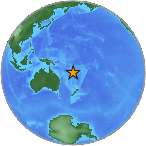
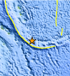
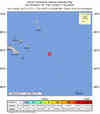
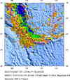
Magnitude 6.7 - SOUTHEAST OF THE LOYALTY ISLANDS
2009 January 15 07:27:21 UTC
Earthquake Details
| Magnitude | 6.7 |
|---|---|
| Date-Time |
|
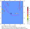
| Location | 22.380°S, 170.623°E |
| Depth | 40.7 km (25.3 miles) |
| Region | SOUTHEAST OF THE LOYALTY ISLANDS |
| Distances | 145 km (90 miles) W of Ile Hunter, Loyalty Isl., New Caledonia 300 km (185 miles) ESE of Tadine, Loyalty Islands, New Caledonia 430 km (265 miles) E of NOUMEA, New Caledonia 1650 km (1030 miles) NNW of Auckland, New Zealand |
| Location Uncertainty | horizontal +/- 5.7 km (3.5 miles); depth +/- 10.4 km (6.5 miles) |
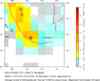
| Parameters | NST=130, Nph=130, Dmin=432.5 km, Rmss=0.84 sec, Gp= 50°, M-type=regional moment magnitude (Mw), Version=A |
| Source |
|
| Event ID | us2009bwaf |
- This event has been reviewed by a seismologist.
- Did you feel it? Report shaking and damage at your location. You can also view a map displaying accumulated data from your report and others.
Earthquake Summary
Felt Reports
WP 7.1 (HDRA).
 Tsunami Information
- NOAA West Coast & Alaska Tsunami Warning Center
- NOAA Pacific Tsunami Warning Center
- Tsunami Information Links
The earthquake locations and magnitudes cited in these NOAA tsunami bulletins are very preliminary and may be superceded by USGS locations and magnitudes computed using more extensive data sets.
Earthquake Maps


Scientific & Technical Information

Additional Information, News Reports
- Preliminary Earthquake Report
- U.S. Geological Survey, National Earthquake Information Center:
World Data Center for Seismology, Denver
