


|
Print Page | |||||||||
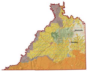
| Monticello Field Office | ||||||||||
The Monticello Field Office is located in the southeast corner of South of the Abajos is the Comb Ridge Monocline, a major crustal uplift about 80 miles in length. Nearby this major uplift is Grand Gulch, which cuts a serpentine swath through Cedar Mesa. The Anasazi Indians left a legacy that includes hundreds of cliff dwellings and thousands of pictographs and petroglyphs. Muley Point Overlook sits on a high rim of Cedar Mesa and offers panoramic sweep across Monticello Field Office |
||||||||||