Hurricane Andrew
Conditions at the Time of the Image
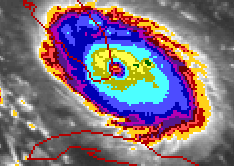
The image displayed in our gallery at 0830 UTC (0430 EDT) on August 24, 1992 depicts Andrew as it was just beginning to make landfall. Lowest central pressure was 922 millibars near Homestead Air Force Base at 0905 UTC, approximately thirty minutes after our image. Maximum sustained surface wind speed, which is a 1-minute average, is estimated to have been 125 knots (about 145 mph) with gusts near 150 knots (175 mph). The sustained speed corresponds to a Category 4 on the Saffir Simpson Hurricane Intensity Scale Andrew came ashore near high tide and brought with it a 16.9 foot storm tide (the sum of the storm surge and astronomical tide) into Biscayne Bay, a record maximum for the southeast Florida peninsula. As with any extremely strong hurricane, the infrared image reveals a symmetric storm with intense convection occurring around a relatively small eyewall. Note the central red core and concentric "eye" to the storm. When the Dvorak analysis technique (a classification system which uses satellite data to estimate the intensity of tropical cyclone systems) was performed using a 0900 UTC satellite image (thirty minutes after our image), a sustained wind speed value of 127 kt was obtained. This estimate is remarkably close to the values obtained from ground-based instruments.
History of the Storm
Hurricane Andrew caused an estimated $26 billion damage in the United States making it the most expensive natural disaster in United States history. At landfall in southern Dade County, Florida, the central pressure was 922 millibars, which is the third lowest this century (after the 1935 Florida Keys Labor Day storm and Hurricane Camille in 1969) for a landfalling hurricane in the U.S.
As with many of the worst Atlantic hurricanes, Andrew was born as a result of a tropical wave which moved off the west coast of Africa wave and passed south of the Cape Verde Islands. It became a tropical storm on August 17, 1992 and moved uneventfully west northwestward across the Atlantic. Significant changes occurred in the large-scale environment of Andrew on August 21 as a deep high pressure center developed over the southeast U.S. and extended eastward to north of the tropical storm. In response to the much more favorable environment, Tropical Storm Andrew strengthened rapidly and turned westward.
Andrew became a hurricane on August 22 and strengthened to a strong category 4 hurricane the next day. As it moved westward, it weakened to 941 millibars as it passed over Great Bahama Bank on the 24th, but rapidly re-intensified as it moved over the Gulfstream on its approach to Florida. In fact, the deepening trend continued up to and slightly inland of the coast. (Eye temperatures as measured by reconnaissance aircraft suggest that convection in the eyewall and associated vertical circulation became more vigorous as the storm moved ashore). The storm devastated Dade County where it caused an estimated $25 billion in damage. After striking Florida, Andrew moved northwest across the Gulf of Mexico to make a second landfall in a sparsely populated area of south-central Louisiana as a Category 3 storm on August 26. In total, Andrew directly caused 23 deaths in the U.S. and indirectly caused 38 more. The number of homes destroyed was 25,524 and 101,241 were damaged.


 Image Information