Alaska Studies
| |
 |
|
| |
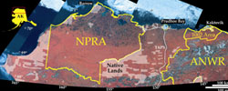
U.S. Geological Survey study areas: NPRA, ANWR 1002 Area, and Central North Slope. |
|
|
|
|
Alaska Energy Issues
Alaska’s scenic wilderness, its Arctic ecosystems with their unique flora and fauna, and its significant potential for energy and mineral resources are unmatched by any other onshore region of the U.S. Thus, the accurate and unbiased scientific data provided by the U.S. Geological Survey are crucial to the Federal, State, and Native organizations that manage Alaska’s resources to meet the challenge of balancing America’s needs for nonrenewable resources and a clean and healthy environment. |
|
|
There are several energy-related efforts currently under way in Alaska. Geographically, these range from the Alaska Peninsula to the North Slope (see graphic on left) and several are collaborative efforts with Federal and State agencies and Alaska Native villages. A brief description of these projects:
Circum-Arctic Basins Oil & Gas Assessment
An ongoing effort of the World Energy Project that includes northern Alaska. The Arctic is an area of high resource potential, low data density, difficult and sensitive environmental conditions, and great uncertainty concerning quantity, quality, distribution, and future availability of oil and gas resources. With Minerals Management Service (MMS) collaboration, northern Alaska, both onshore and offshore, will be included in the assessment as an example of one of the better-known resource-rich basins of the Arctic.
Geologic Framework and Assessment Studies, North Slope of Alaska
These studies will increase our understanding of the petroleum geology and improve our estimates of undiscovered oil and gas resources. This is a multi-disciplinary investigation that uses concepts of basin analysis, sequence stratigraphy, fluid-flow modeling, petroleum systems, and structural and geophysical analysis. Assessments of the NPRA and the central North Slope were completed in May 2002 and May 2005, respectively. Current work is focused on assessment of the area west of NPRA and aggregation of all North Slope assessments with an update of the economics, including natural gas.
Gas Hydrate Studies in northern Alaska
These studies will investigate the technical aspects of gas production from gas hydrates, which contain gas trapped with water in ice-like structures. The presence of huge volumes of gas in hydrate form is known in the Prudhoe Bay region from earlier USGS studies. The current work is a collaborative effort involving the USGS Coastal and Marine Geology Program, Bureau of Land Management (BLM), the State of Alaska, the U.S. Department of Energy, and private industry. Collaborative gas hydrate work has also been conducted with the multinational Mallik Drilling Consortium in the Mackenzie Delta region. In 2004, the Alaska State Legislature requested the U.S. Geological Survey (USGS) to provide a technical briefing on the energy resource potential of gas hydrates in northern Alaska at a Federal Energy Regulatory Commission (FERC) technical conference, USGS Open-File Report 2004–1454.
Coalbed Gas Studies
A cooperative project with the State partly funded by the BLM and DOE to evaluate coalbed gas resources near Native villages and on Federal lands in rural Alaska. Coalbed gas may be a viable local energy source for Native villages and a commercial resource in Alaska. Shallow coalbed gas wells have been drilled near Chignik, Fort Yukon, and the Dalton Highway south of Prudhoe Bay. Current work involves continued evaluation of drill sites and collecting and analyzing coal samples for their methane potential from wells drilled for oil and gas in Cook Inlet and the North Slope. A new coal assessment of Alaska was released in 2003.
Digital Geologic Map Compilation
Compilation of existing geologic maps of the northern foothills of the Brooks Range, from the Chukchi Sea eastward to the Canadian border. This work is a collaboration between the USGS and the Alaska Department of Natural Resources, Division of Geological and Geophysical Surveys (DGGS) and the Division of Oil and Gas. It will result in a synthesis of geologic mapping that was conducted independently over several decades by the USGS and DGGS and will be produced at a fraction of the cost of new, field-based geologic mapping of the same area. A report of revised stratigraphic nomenclature for common use on all maps was completed in 2003, the Umiat quadrangle map was released in 2004, and the Ikpikpuk River quadrangle map, in 2005. A digital compilation of northeastern NPRA surficial geology was completed in 2005 at the request of the BLM.
Interior Alaska Province Review and Yukon Flats Assessment
An effort to provide essential geologic, geophysical, geochemical, and historical information in preparation for the next USGS assessment of the oil and gas resources in this province. Assessment of the Yukon Flats basin was released in 2004. A comprehensive review and compilation of oil and gas related information for the entire province was completed in 2002.
South Alaska Province Review
A
new effort initiated in 2003 and focused on Cook Inlet. It is designed to provide essential geologic, geophysical, geochemical, and historical information in preparation for the next USGS assessment of the oil and gas resources in this province.
Collaboration with State of Alaska
Although not a separate project, the Energy Resources Program provides staff, analytical capabilities, and financial support for Alaskan petroleum studies and geologic mapping conducted by the Alaska Department of Natural Resources, Division of Geologic and Geophysical Surveys and Division of Oil and Gas.
 |
 |
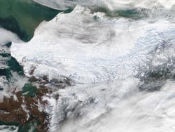
| A blanket of snow gives the Brooks Range Mountains in northern Alaska an etched appearance in this true-color Moderate Resolution Imaging Spectroradiometer (MODIS) image from October 15, 2002. (Credit: Jacques Descloitres, MODIS Rapid Response Team, NASA/GSFC). |
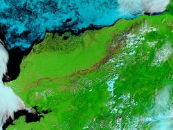
Summertime glows green across Northern Alaska in the true-color Terra MODIS image, which was acquired July 29, 2002. Prominent in the image is the Brooks Range, which stretches all the way across Northern Alaska from the western shore to the border of Canada’s Yukon Territory, a distance of about 600 miles. (Credit: Jacques Descloitres, MODIS Rapid Response Team, NASA/GSFC). |
Top of Page