Katrina was a tropical depression that briefly became a 35-knot tropical
storm while moving onshore on the Caribbean coast of Nicaragua.
a. Synoptic history
Satellite imagery suggests that the remnants of a cold front moved slowly
southward across the western Caribbean Sea beginning on 22 October. A broad
area of low pressure gradually formed over much of the Caribbean during this
time and cloudiness and thunderstorms became
concentrated over the southwestern Caribbean Sea on the 26th of
October. On the 27th, low-level cloud lines began to show a
circulation just north of Panama. On the 28th, a reconnaissance
aircraft reported a well-defined low-level circulation about 150 n mi
east of Bluefields, Nicaragua and tropical depression fifteen had
formed. The best track begins at 1800 UTC on the 28th as indicated in
Table 1, which is a listing, every six hours,
of best track positions,
maximum one-min surface wind speeds, and minimum central surface
pressure. A map of the best track positions is shown in
Figure 1.
Katrina was a tropical storm for about six hours from 1800 UTC on the
29th to 0000 UTC on the 30th, while making landfall on
the coast of Nicaragua just south of Puerto Cabezas. For the rest of
its four days of existence, Katrina was a tropical depression that moved
on a generally northwestward track across Nicaragua and Honduras, back
over the water of the northwest Caribbean, and then across northern
Belize and the Yucatan Peninsula. The depression dissipated on the
1st just north of the Yucatan Peninsula as it was absorbed by a
cold front.
b. Meteorological statistics
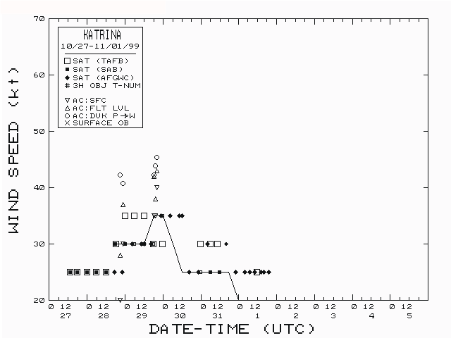
The best track pressure and wind speed time series curves are shown in
Figure 2 and Figure 3, along
with plots of the data on which the curves are
based. The system was monitored by reconnaissance aircraft on the
28th and 29th of October while located in the
southwestern Caribbean Sea. The basis for naming Katrina a tropical storm
was a 43-knot, 1500-feet flight level wind observation at 1824 UTC on the
29th.
Satellite-based rainfall estimates suggest that 10 to 15 inches of rain
may have ocurred over portions of Nicaragua and Honduras and lesser
amounts for the Yucatan Peninsula. A report of 3.58 inches of rain in six
hours was received on the 28th from San Andres, Colombia, an
island about 100 n mi east of the coast of Nicaragua.
c. Casualties and damages
It is possible that the rainfall described above caused some flash flooding
over mountainous terrain over portions of Central America. No reports of
damage or casualties have been received.
d. Forecast and warning critique
A tropical storm warning was issued for the east coast of Nicaragua at 0000
UTC on the 29th and for the San Andres Islands at 0300 UTC.
This was a lead time of 24 hours for the Nicaragua coast, as Katrina made
landfall as a tropical storm at 0000 UTC on the 30th. The
warnings for San Andres and for the east coast of Nicaragua south of
Bluefields were discontinued on 1500 UTC on the 29th. The
warnings for the remainder of the east coast of Nicaragua were discontinued
at 0300 UTC on the 30th.
Statistics of track and intensity forecasts are calculated only for
forecasts when the tropical cyclone is a tropical storm or hurricane. Since
Katrina was a tropical storm very briefly, there are no meaningful
statistics of track and wind speed forecast errors to report on.

Figure 1.
Best track positions for Tropical Storm Katrina, 28 October-01 November 1999.

Figure 2.
Best track maximum-one-min-surface-wind-sped vs. time curve for Tropical
Storm Katrina, 28 October-01 November 1999.

Figure 3.
Best track minimum-central-surface-pressure vs. time curve for Tropical
Storm Katrina, 28 October-01 November 1999.
Table 1.
Preliminary Best Track, Tropical Storm Katrina, 28 October-1 November 1999.
Date/Time
(UTC) | Position |
Pressure
(mb) |
Wind Speed
(kt) | Stage |
| Lat. (°N) | Lon. (°W) |
| 28/1800 | 11.4 | 80.9 | 1001 | 30 | tropical depression |
| 29/0000 | 11.6 | 81.6 | 1001 | 30 | " |
| 0600 | 12.0 | 82.0 | 1001 | 30 | " |
| 1200 | 12.6 | 82.6 | 1000 | 30 | " |
| 1800 | 13.2 | 82.9 | 1000 | 35 | tropical storm |
| 30/0000 | 13.8 | 83.4 | 999 | 35 | " |
| 0600 | 14.1 | 84.0 | 1000 | 30 | tropical depression |
| 1200 | 14.3 | 84.5 | 1001 | 25 | " |
| 1800 | 14.7 | 85.2 | 1003 | 25 | " |
| 31/0000 | 16.0 | 86.6 | 1005 | 25 | " |
| 0600 | 17.2 | 87.4 | 1007 | 25 | " |
| 1200 | 18.4 | 88.0 | 1008 | 25 | " |
| 1800 | 19.4 | 88.7 | 1009 | 25 | " |
| 01/0000 | 19.9 | 89.6 | 1010 | 20 | " |
| 0600 | 20.4 | 89.8 | 1011 | 20 | " |
| 1200 | 21.2 | 89.8 | 1011 | 20 | " |
| 1800 | | dissipated |
| 30/0000 | 13.8 | 83.4 | 999 | 35 | landfall just south of Puerto Cabezas, Nicaragua |
| 30/0000 | 13.8 | 83.4 | 999 | 35 | minimum pressure |
![[NCEP Logo]](graphics/ncep.gif)