This hurricane originated from a tropical wave that moved off the west coast
of Africa on 8 October. The wave moved slowly westward across the tropical
Atlantic for several days. By 15 October, when the system was located about
midway between Africa and the Lesser Antilles, its associated shower
activity became better organized. The initial satellite classifications, a
T1.0 on the Dvorak scale, were done at 1200 UTC 17 October. The disturbance
developed into a tropical depression by 1800 UTC that same day, while
located about 700 miles east of the southern Windward Islands. There was
well-defined upper-tropospheric outflow over the depression. Moving
west-northwestward, the depression strengthened into Tropical Storm Jose on
the 18th while centered about 400 miles east of the Windward Islands.
Initially, it appeared that a large mid-tropospheric high over the
southwestern north Atlantic would steer the tropical cyclone on a westward
to west-northwestward track for several days. However, a mid- to
upper-tropospheric trough produced a weakness in the ridge in the vicinity
of Puerto Rico. This imparted a more northward component to Jose's
motion. After turning toward the northwest, Jose became a hurricane late
on the 19th while centered about 150 miles east of the Leeward Islands. As
it neared these islands, Jose reached its peak intensity of 85 knots at
1200 UTC 20 October. Turning back to a west-northwest heading, Hurricane
Jose struck the northern Leeward Islands, passing over Antigua around
midday on the 20th. The eye then moved near St. Barthelemy and St. Martin
from 0000 to 0300 UTC on the 21st.
As Jose moved over the northern Leeward Islands, southwesterly vertical
shear adversely impacted the tropical cyclone's intensity. Jose weakened
to a tropical storm by the time it reached Tortola in the British Virgin
Islands, around 1100 UTC on the 21st. A little later on the 21st, the
cyclone turned back toward the northwest, as the center passed about 50
miles northeast of the eastern tip of Puerto Rico. With a large mid- to
upper-tropospheric trough positioned over the western North Atlantic,
recurvature was now imminent. Jose turned northward, then
north-northeastward on the 22nd. The storm continued
north-northeastward at a faster forward speed on the 23rd,
its structure still disrupted by southwesterly shear. Early on the
24th, however, microwave data indicated that the low-level center
was becoming more involved with the deep convection. Satellite intensity
estimates indicate that Jose regained hurricane strength by 1200 UTC 24
October. The hurricane passed about 300 miles east of Bermuda around midday
on the 24th, and the forward speed increased markedly. The
rejuvenation of the tropical cyclone was short-lived. Jose weakened back to
a tropical storm around 0000 UTC 25 October. It continued to accelerate into
the North Atlantic, losing tropical characteristics by 1200 UTC on the
25th. Later that day, the system merged with a larger
mid-latitude low and associated front.
b. Meteorological Statistics
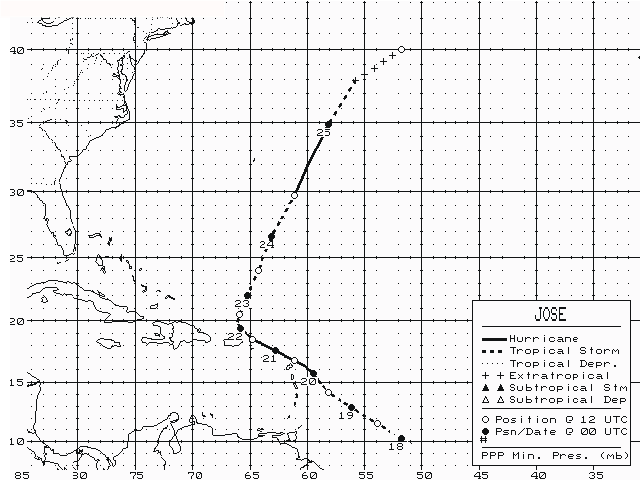
Table 1 lists the best track positions and intensities
of Jose at six-hourly intervals. Figure 1 is a display of
this track.
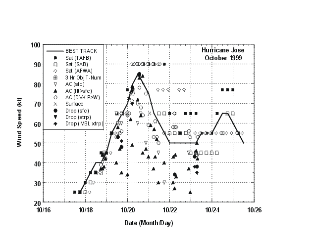
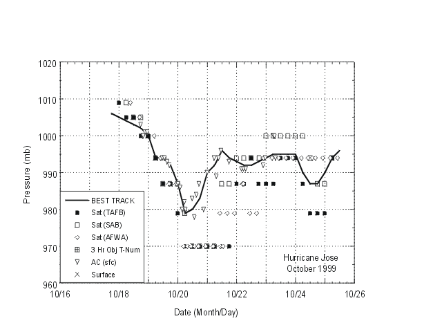
Figure 2 and Figure 3 depict the
curves of minimum central sea-level pressure and maximum one-minute
average "surface" (10 meters above ground level) wind speed, respectively,
as a function of time. Also plotted are the observations on which the
curves are based, consisting of aircraft reconnaissance and dropsonde data
from the U.S. Air Force Reserves (the Hurricane Hunters) and NOAA, surface
synoptic data, as well as Dvorak-technique estimates from the Tropical
Analysis and Forecast Branch (TAFB), the Satellite Analysis Branch (SAB),
and the U.S. Air Force Weather Agency (AFWA) using satellite imagery. In
Figure 2, the aircraft flight level wind measurements
have been adjusted for elevation (90% of 700 mb wind speeds, 80% of 850 mb
speeds, and 85% of 1500 ft speeds), and dropsonde wind measurements above
the surface are adjusted to the 10 meter level using a mean hurricane
eyewall profile determined by previous dropsonde measurements.
Jose's peak intensity of 85 knots is based on: 1) 10 meter winds of that
speed measured by a Global Positioning System dropsonde, and 2) 90% of 700
mb flight level winds of 92 knots.
Table 2 lists selected surface observations for Jose.
The highest measured wind speed from a surface reporting station was 70
knots with a gust to 89 knots at Antigua. Sustained winds of hurricane
force (65 knots) were also measured at St. Maarten. The highest wind
measurement from the Virgin Islands was 52 knots (sustained) with a gust
to 60 knots at St. John. Higher wind speeds likely occurred over portions
of the British Virgin Islands. In Puerto Rico, winds were mostly below
tropical storm force, however there was an unofficial measurement (from a
portable anemometer) of sustained winds of 30 to 39 knots with a gust to
48 knots from Costa Azul Beach in Luquillo.
Very heavy rains fell well after the passage of the center over the northern
Leeward Islands, in association with feeder bands well east or southeast of
the center. Rainfall totals were as high as 12 to 15 inches over portions of
the islands.
A ship with call sign 9HII6, located at 31.6N 59.5W, reported winds
of 130/85 knots on 24 October 1200 UTC. Further investigation of this
observation revealed that the wind speed was erroneously reported to be
about double its true value.
Storm surge observations are not available.
No tornadoes were reported in association with Jose.
c. Casualty and Damage Statistics
Two deaths are known to have been caused by Jose, one in Antigua and one in
St. Maarten. Damage in Antigua was characterized as "minor". In St.
Maarten, the heavy rains caused extensive flooding and mud slides which
damaged roads and homes, especially in low-lying areas. United States
(Puerto Rico and the U.S. Virgin Islands) damage totals are minimal, and
apparently did not exceed 5 million dollars.
d. Forecast and Warning Critique
Table 3 lists the average track errors for Jose for
various forecast models and the official forecast. In the mean, the
official forecasts were comparable to the most recent ten-year averages
through 36 hours, but considerably worse at 48 and 72 hours. It can be
seen that normally reliable models such as the GFDL and the UKMI also had
quite large average errors at the latter two time periods. It should be
noted that due to computer problems at the National Center for
Environmental Prediction's (NCEP's) Central Operations, the GFDL model was
run in a lower resolution (two-nested grids) than normal. These problems
also caused some potentially valuable dropsonde data in the environment of
Jose from the NOAA G-IV jet aircraft to be excluded from the NCEP global
analysis.
In most cases, the official forecasts had a leftward bias. During the first
couple of days of Jose's existence, the sharp recurvature to the north of
Puerto Rico was not anticipated. In the latter part of Jose's lifetime, the
official forecasts were generally too fast, taking the cyclone much too far
north into the Atlantic.
Generally, the intensity of Jose was overpredicted in the official
forecasts. Wind speed forecast errors were as large as 40 to 50 knots (too
high) in 24 to 48 hours. It was not anticipated that southwesterly shearing
would cause weakening. The SHIPS model also overpredicted the strength of
Jose, although the errors tended to be a bit less than the official
forecasts. It should be noted that, again due to computer problems, the
SHIPS guidance was not available for about one third of the forecasts.
Table 4 lists the various watches and warning issued
for Jose. Hurricane warnings were issued more than 24 hours in advance of
the time of closest approach of the center to Antigua and St. Maarten, but
only about 12 hours in advance for St. Barthelemy and St. Martin.
Hurricane warnings for the Virgin Islands and Puerto Rico proved to be
unneccessary, due to deficiencies in the track and intensity forecasts.

Figure 1.
Best track, Hurricane Jose, 17-25 October, 1999

Figure 2.
Best track maximum sustained wind speed curve for Hurricane Jose, showing
all available intensity estimates and wind observations, adjusted for
elevation (90% of 700 mb flight level wind speeds, 80% of 850 mb speeds, and
85% of 1500 ft speeds. Dropsonde wind speeds are adjusted to the surface
using a mean eyewall profile determined by previous dropsonde measurements.
MBL denotes mean boundary layer).

Figure 3.
Best track minimum central pressure curve and central pressure observations
or estimates for Hurricane Jose.
Table 1.
Best track, Hurricane Jose, 17-25 October, 1999
Date/Time
(UTC) | Position |
Pressure
(mb) |
Wind Speed
(kt) | Stage |
| Lat. (°N) | Lon. (°W) |
| 17 / 1800 | 9.8 | 50.8 | 1006 | 25 | tropical depression |
| 18 / 0000 | 10.3 | 51.8 | 1005 | 30 | " |
| 18 / 0600 | 10.9 | 52.8 | 1004 | 35 | tropical storm |
| 18 / 1200 | 11.5 | 53.9 | 1003 | 40 | " |
| 18 / 1800 | 12.2 | 55.1 | 1002 | 40 | " |
| 19 / 0000 | 12.9 | 56.1 | 1000 | 45 | " |
| 19 / 0600 | 13.5 | 57.1 | 994 | 55 | " |
| 19 / 1200 | 14.1 | 58.1 | 994 | 60 | " |
| 19 / 1800 | 14.9 | 58.9 | 992 | 65 | hurricane |
| 20 / 0000 | 15.7 | 59.5 | 987 | 70 | " |
| 20 / 0600 | 16.3 | 60.2 | 979 | 80 | " |
| 20 / 1200 | 16.8 | 61.1 | 980 | 85 | " |
| 20 / 1800 | 17.2 | 62.0 | 983 | 80 | " |
| 21 / 0000 | 17.6 | 62.7 | 990 | 75 | " |
| 21 / 0600 | 18.1 | 63.8 | 992 | 65 | " |
| 21 / 1200 | 18.5 | 64.8 | 996 | 60 | tropical storm |
| 21 / 1800 | 19.0 | 65.3 | 994 | 55 | " |
| 22 / 0000 | 19.4 | 65.8 | 993 | 50 | " |
| 22 / 0600 | 19.9 | 66.1 | 992 | 50 | " |
| 22 / 1200 | 20.5 | 65.9 | 992 | 50 | " |
| 22 / 1800 | 21.1 | 65.6 | 993 | 50 | " |
| 23 / 0000 | 22.0 | 65.2 | 994 | 50 | " |
| 23 / 0600 | 23.0 | 64.8 | 995 | 50 | " |
| 23 / 1200 | 24.0 | 64.3 | 995 | 55 | " |
| 23 / 1800 | 25.2 | 63.8 | 995 | 55 | " |
| 24 / 0000 | 26.6 | 63.1 | 995 | 55 | " |
| 24 / 0600 | 28.0 | 62.2 | 990 | 60 | " |
| 24 / 1200 | 29.7 | 61.1 | 987 | 65 | hurricane |
| 24 / 1800 | 32.2 | 59.8 | 987 | 65 | " |
| 25 / 0000 | 34.9 | 58.1 | 990 | 60 | tropical storm |
| 25 / 0600 | 37.9 | 55.8 | 994 | 55 | " |
| 25 / 1200 | 40.0 | 51.8 | 996 | 50 | extratropical |
| 25 / 1800 | | absorbed by larger extratropical low |
| |
| 20 / 1200 | 16.8 | 61.1 | 980 | 85 | maximum intensity |
| 20 / 0600 | 16.3 | 60.2 | 979 | 80 | minimum pressure |
| |
| 20 / 1600 | 17.1 | 61.7 | 982 | 80 | landfall at Antigua |
| 21 / 1105 | 18.4 | 64.6 | 996 | 60 | landfall at Tortola |
Table 2. Hurricane Jose, selected surface observations, October, 1999.
| |
Minimum
sea-level
pressure |
Maximum surface wind speed
(kt) |
|
| Location |
Pressure
(mb) |
Date/time
(UTC) |
Sustained
winda
(kts) |
Peak
gust (kts) |
Date/timeb
(UTC) |
Storm
surgec
(ft) |
Storm
tided
(ft) |
Rain
(storm total)
(in) |
| Leeward Islands |
| Antigua | 982.0 | 20/1600 | 70 | 89 | 20/1523 | | | 7.64 |
| Desirade | | | 50 | 65 | 20/0800 | | | |
| St. Barthelemy | 996.0 | 21/0000 | 54 | 78 | 21/0000 | | | |
| Sint Maarten (Juliana Airport) | 992.0 | 21/0214 | 65 | 87 | 21/0116 | | | 11.03 |
| Sint Maarten (Point Blanche) | | | | | | | | 13.75 |
| U.S. Virgin Islands |
| St. Croix ASOS | 999.7 | | 27 | 32 | 21/1255 | | | 1.05 |
| St. John (NWS sensor F420C) | | | 52 | 60 | 21/1657 | | | |
| St. Thomas ASOS | | | | | | | | 0.90 |
| St. Thomas Mount Zion | | | | | | | | 2.93 |
| St. Thomas National Park Svc | | | | | | | | 1.62 |
| Puerto Rico |
| Aguas Buenas | | | | | | | | 5.43 |
| Carolina (SJU) ASOS | 1001.7 | 21/1902 | 20 | 26 | 21/1005 | | | 1.30 |
| Carolina | | | | | | | | 2.97 |
| Ceiba (TJNR) ASOS | 1001.0 | 21/1854 | 25 | 32 | 21/1216 | | | 1.14 |
| Cupey Rio Piedras | | | | | | | | 3.96 |
| Gurabo Abajo | | | | | | | | 3.87 |
| Hatillo | | | | | | | | 3.65 |
| Jagueyes Abajo | | | | | | | | 3.69 |
| Manati-Orocovis | | | | | | | | 2.42 |
| Naranjito | | | | | | | | 3.47 |
| Orocovis | | | | | | | | 4.19 |
| Rio Fajardo | | | | | | | | 3.28 |
| Rio Grande | | | | | | | | 4.15 |
| Rio Grande near El Verde | | | | | | | | 4.34 |
| Rio Icacos Naguabo | | | | | | | | 6.18 |
| Rio Piedras | | | | | | | | 4.05 |
aASOS are 2-minute averages, Desirade and St. Barthelemy are 10-minute averages, all others are 1-minute averages.
bDate/time is for sustained wind when both sustained and gust are listed.
cStorm surge is water height above normal astronomical tide level.
dStorm tide is water height above National Geodetic Vertical Datum (1929 mean sea level).
Table 3.
Preliminary forecast evaluation of Hurricane Jose, heterogeneous sample.
(Errors in nautical miles for tropical storm and hurricane stages with
number of forecasts in parenthesis).
| Forecast Technique |
Period (hours) |
| 12 | 24 | 36 | 48 | 72 |
| CLIP | 53 (27) | 117 (25) | 186 (23) | 263 (21) | 391 (17) |
| GFDI | 44 (15) | 102 (14) | 215 (12) | 331 (11) | 578 (8) |
| GFDL* | 36 (13) | 48 (12) | 104 (11) | 185 (10) | 426 (8) |
| LBAR | 37 (22) | 51 (20) | 71 (18) | 100 (16) | 183 (13) |
| AVNI | 52 (19) | 93 (18) | 132 (17) | 197 (15) | 278 (9) |
| BAMD | 39 (27) | 66 (25) | 109 (23) | 176 (21) | 397 (17) |
| BAMM | 48 (26) | 80 (24) | 117 (22) | 156 (20) | 273 (17) |
| BAMS | 64 (26) | 111 (24) | 150 (22) | 178 (20) | 202 (16) |
| A98E | 43 (26) | 85 (24) | 119 (22) | 149 (20) | 226 (16) |
| NGPI | 133 (10) | 198 (10) | 218 (10) | 216 (8) | 238 (8) |
| UKMI | 55 (24) | 106 (22) | 179 (20) | 282 (18) | 431 (14) |
| |
| NHC OFFICIAL | 39 (27) | 72 (25) | 139 (23) | 235 (21) | 384 (17) |
| NHC OFFICIAL 1989-1998 10-year average | 48 (2005) | 89 (1790) | 128 (1595) | 164 (1410) | 242 (1107) |
*GFDL output not available until after forecast issuance.
Table 4.
Watch and warning summary, Hurricane Jose, October, 1999.
Date/Time
(UTC) |
Action |
Location |
| 18/0900 | Hurricane watch issued | Barbados |
| 18/1200 | Tropical storm watch issued | Trinidad and Tobago |
| 18/2100 | Hurricane watch issued | Grenadines, St. Vincent, St. Lucia, and Dominica |
| 18/2100 | Tropical storm warning issued | Barbados |
| 18/2100 | Tropical storm watch issued | Grenada |
| 18/2100 | Tropical storm watch discontinued | Trinidad and Tobago |
| 19/0000 | Hurricane watch issued | Martinique, Guadeloupe, Antigua, Barbuda, Montserrat, St. Kitts, Nevis, and Anguilla |
| 19/0300 | Hurricane watch issued | St. Eustatius, Saba, St. Maarten, St. Martin, and St. Barthelemy |
| 19/0600 | Hurricane watch changed to tropical storm watch | St. Vincent and the Grenadines |
| 19/0600 | Hurricane watch discontinued | Barbados |
| 19/0900 | Hurricane warning issued | Dominica, Martinique, and Guadeloupe |
| 19/0900 | Tropical storm watch discontinued | Grenada |
| 19/1500 | Hurricane warning issued | Dominica, Montserrat, Antigua, Barbuda, Nevis, St. Kitts, St. Eustatius, Saba, St. Maarten, and Anguilla |
| 19/1500 | Hurricane watch issued | British and U.S. Virgin Islands, and Puerto Rico |
| 19/1500 | Tropical storm warning issued | St. Lucia |
| 19/1500 | Tropical storm watch discontinued | St. Vincent and the Grenadines |
| 19/2100 | Hurricane warning issued | British and U.S. Virgin Islands, and Puerto Rico |
| 19/2100 | Hurricane watch discontinued | St. Lucia |
| 20/0000 | Hurricane warning issued | Guadeloupe |
| 20/0300 | Tropical storm warning discontinued | St. Lucia and Barbados |
| 20/1200 | Hurricane warning issued | Desirade, St. Martin, and St. Barthelemy |
| 20/1200 | Hurricane warning discontinued | Guadeloupe |
| 20/1500 | Hurricane warning discontinued | Dominica |
| 20/2100 | Hurricane warning discontinued | Antigua and Desirade |
| 21/0900 | Hurricane warning changed to tropical storm warning | U.S. Virgin Islands and Puerto Rico |
| 21/0900 | Hurricane warning discontinued | St. Maarten, St. Eustatius, and Saba |
| 21/1500 | Hurricane warning discontinued | Montserrat, Barbuda, Nevis, St. Kitts, Anguilla,St. Martin, and St. Barthelemy |
| 21/1500 | Hurricane warning changed to tropical storm warning | British Virgin Islands |
| 21/2100 | Tropical storm warning discontinued | British and U.S. Virgin Islands, and Puerto Rico |
![[NCEP Logo]](graphics/ncep.gif)