


|
Print Page | ||||||||||||
| Vernal Field Office | |||||||||||||
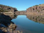
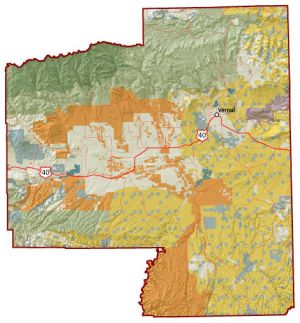
The Vernal Field Office is located in the northeast corner of Utah and administers lands within Daggett, Duchesne and Uintah Counties, plus a small portion of Grand County. The Vernal Field Office also has Native American Trust responsibilities for Northern Ute Tribal and allotted mineral trust lands located within these counties. The area includes the south slope of the Uinta Mountains, the Uinta Basin, and the Book Cliffs region. The management area in northeastern Utah includes the Uinta Basin, the east and west Tavaputs Plateaus, the Eastern Uinta Mountains (northern boundary), the Book Cliffs (southern boundary), Diamond Mountain, Nine Mile Canyon, and Browns Park. The area is bounded on the west by the Wasatch Mountains and on the east by the Douglas Creek Arch in Colorado. There are approximately 5,518,859 acres within the boundary of the Vernal Field Office, of which 1,725,500 acres are BLM managed surface lands. The Vernal Field Office administers energy related mineral activities on 3.8 million acres of Federal mineral lands (includes 1.3 million acres of National Forest Service lands) and post lease mineral operations on Indian trust mineral lands. The 1,911,000 acres of BLM managed mineral estate includes the split estate mineral lands within the Hill Creek Extension (comprises 185,500 acres of mineral estate underlying Indian trust surface). The Vernal Field Office was designated as a Pilot Office under the Energy Policy Act of 2005. The managed lands contain oil and gas along with other unique mineral resources such as Gilsonite, oil shale, and tar sands. Eight-hundred eighty-eight APDs were approved during fiscal year 2006. |
|||||||||||||