FIA Library
Maps
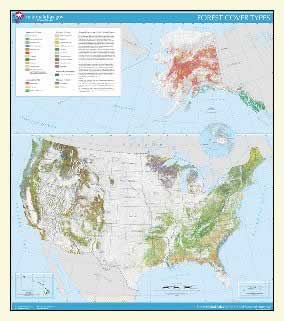
Forest Types of the United States
As a part
of the 1997 Resource Planning Act
Assessment, FIA collaborated with
the US Geological Survey to update
the 'Forest Types of the United
States" map last published in 1993. This
new map shows the forests of the
United States grouped into 27 major
forest types. The map includes
Alaska, Hawaii, Puerto Rico, and
the Virgin Islands, all mapped
at the same 1:7,500,000 scale,
Albers equal area projection. Various
versions of the map are available
including:
- Full
view of the finished map, in GIF format (48
K). This
version of the map is simply a small graphic
file suitable for inclusion in a report, but
with minimal
detail visible and no real analytical uses.
- Full
view of the finished map, in Acrobat
(.PDF) format (3.9 M). This
version of the map is a high resolution
.PDF file which includes the full
map (including key and scale). It
can be zoomed in to read the fine
detail, and can be printed at full
scale (36" x 40"), or print at 25%
size to fit on a standard 8.5 x 11
page.
- Forest
Type coverage in GEOTIFF format (1.8
M). This version of the
map is a unified image of forest cover
for all 50 states + Puerto Rico and
the US Virgin Islands, in Lambert
Azimuthal equal-area projection centered
at (-100,45). This is
all the forest data in one large georeferenced
image with no relief shading or map
collar. This version is suitable
for further analysis using image processing
or GIS tools. The file is compressed
(tar format); decompressed size is
over 75 M.
Metadata for this map are
available at http://www.nationalatlas.gov/fortypem.html
This map, along with many other
useful map layers, are available electronically
at the US National Atlas,
an outstanding online resource for US mapped information. Paper
copies of this and other maps are also available
through the US
National Atlas.

You will need Acrobat Reader to view .pdf documents.
Click here to download a free copy of Acrobat Reader. |
