NOAA Logo Image

NATIONAL WEATHER SERVICE
NATIONAL FIRE WEATHER PAGE

Note on changes...Local Boise Fire Weather Page


NWS Logo Image


NATIONAL FIRE WEATHER FORECASTS / OFFICES / OUTLOOKS

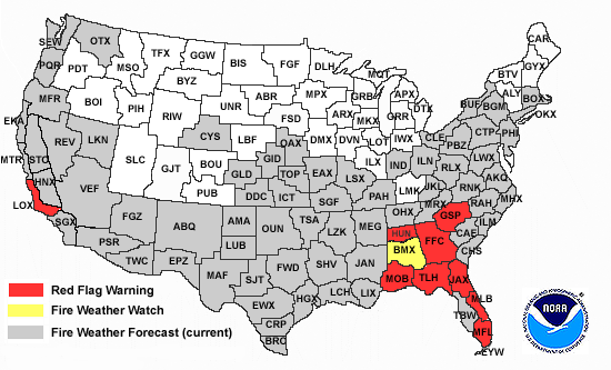
Click area on map for Fire Weather Forecast:


Alaska

Hawaii

Puerto
Rico


Seattle Spokane Pendleton Portland Missoula Great Falls Glasgow Boise Pocatello Billings Riverton Elko Salt Lake City Flagstaff Grand Junction Bismarck Aberdeen Rapid City Grand Forks Cheyenne Denver Pueblo Albuquerque Tucson El Paso Duluth Minneapolis Sioux Falls North Platte Goodland Dodge City Amarillo Lubbock Midland/Odessa Marquette Green Bay La Crosse Milwaukee Des Moines Omaha Hastings Kansas City Topeka Wichita Oklahoma City Tulsa Fort Worth San Angelo San Antonio Corpus Christi Brownsville Houston Davenport Chicago Lincoln St. Louis Springfield Little Rock Shreveport Lake Charles Gaylord Grand Rapids Detroit North Webster Indianapolis Paducah Memphis Jackson New Orleans Cleveland Wilmington Louisville Nashville Mobile Tallahassee Caribou Portland Burlington Albany Boston Buffalo Binghamton New York State College Philadelphia Pittsburgh Baltimore/Washington Wakefield Charleston Jackson Blacksburg Newport Raleigh Morristown Greenville/Spartanburg Wilmington Columbia Atlanta Charleston Jacksonville Melbourne Tampa Miami Key West Las Vegas Las vegas Phoenix Reno Las Vegas San Diego Los Angeles Hanford Sacramento Eureka Monterey Medford OR Medford CA HUNFWFHUN BHMFWFBMX US Map Firewx

Office Websites

Red Flag Warnings / Watches

Fire Weather Outlooks

 
30-90 day outlook SPC fire weather outlook

OBSERVATIONS / RAWS / HAINES INDEX

All U.S. RAWS Data (Text)

RAWS Summaries
(now includes 12 and 24 hour summaries)

RAWS Location Info

Current Conditions

WFAS / Fire Danger

Haines Index

 Alaska Fire Service

RADAR / SATELLITE

RADAR:
NWS Radar - Through this site you may access any NWS radar page.
SATELLITE:

AREA

VISIBLE

IR (INFRARED)

WATER VAPOR

West U.S.

image

loop image loop image loop
East U.S. image  loop   image  loop   image  loop  

Alaska Region HQ satellite images GOES POES

RAMSDIS Online - Excellent source of both western and eastern satellite imagery.


DROUGHT

Palmer Drought Index Keetch-Byram Drought Index Drought Monitor

TEMPERATURE, RAINFALL, SNOWPACK DATA

Precipitation and Snowpack

Westwide Summary


COORDINATION CENTERS / SITUATION REPORTS

Coordination Centers Situation Reports (may need Acrobat Reader)


Link to Map of Current Fires (from USGS)

Wildland Fire Assessment System

Fire Season 2007 NWS National Fire Weather Report and Red Flag Verification >

ATMU-Reports


Webmaster
US Dept of Commerce
National Oceanic and Atmospheric Administration
National Weather Service
Boise Weather Forecast Office
NIFC Building 3807
Boise, ID 83705-5354

Tel: (208) 334-9860
Disclaimer
Information Quality
Credits
Glossary
Privacy Policy
Freedom of Information Act
About Us
Career Opportunities

National Weather Service Mission: "The National Weather Service (NWS) provides weather, hydrologic, and climate forecasts and warnings for the United States, its territories, adjacent waters and ocean areas, for the protection of life and property and the enhancement of the national economy. NWS data and products form a national information database and infrastructure which can be used by other governmental agencies, the private sector, the public, and the global community."