
- HOME
- EXPLORE
- Oceans
- Coasts
- Coastal Decision-making Tools
- Coastal Ecosystem Science
- Coastal Zone Management
- Coastal Monitoring and Observations
- Contaminants in the Environment
- Ecological Forecasting
- Harmful Algal Blooms
- National Estuarine Research Reserves
- Natural Hazards Assessment
- Natural Resource Restoration
- Training and Capacity- Building
- Charting and Navigation
- EDUCATION
- DATA EXPLORER
- NEWS
- OFFICES
- Center for Operational Oceanographic Products and Services
- International Program Office
- Management and Budget Office
- National Centers for Coastal Ocean Science
- National Geodetic Survey
- Office of National Marine Sanctuaries
- NOAA Coastal Services Center
- Office of Coast Survey
- Office of Ocean and Coastal Resources Management
- Office of Response and Restoration
- OUTREACH
- PUBLICATIONS
- WEB SITES
- ABOUT

|
|
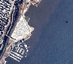
Since the late 1930s, high-resolution, georeferenced aerial photography for defining the nation's 95,000-mile shoreline has been a responsibility of the National Geodetic Survey (NGS), part of NOAA's National Ocean Service (NOS). Metric aerial photographs are the primary source material used for creating coastal survey maps and digital cartographic feature files. These data sets, in turn, provide data for producing NOAA nautical charts. Determining the accurate location of the shoreline is extremely important because it is used as a source to define the boundaries between private, state, and federal ownership and jurisdictions, including the territorial sea and the Exclusive Economic Zone. Tidal datum lines derived from the NOAA nautical chart are a source used to determine such marine and maritime limits. These photographs have many other uses as well, including coastal management, waterfront development, natural resource identification, water-depth measurements, topographic mapping, sea-bed characteristic mapping, and location of features or obstructions to ensure the safety of marine and air navigation. The primary aerial photographic product is a 9x9-inch color photograph, usually at scales from 1:10,000 to 1:50,000. More than 500,000 photo negatives, dating from 1945 to the present year, exist in NOS archives and are maintained by NGS. Aerial photography surveys are conducted on varying time cycles, depending on the amount of change caused by human or natural forces. Other types of photographs include panchromatic, false-color infrared, and black-and-white infrared. Photography is acquired when weather conditions, sun angle, and, when applicable, water levels are optimal to ensure that photographs will be suitable for a variety of purposes using standard photogrammetric techniques. NOS now manages the majority of its mapping projects through contracts with private mapping firms. These firms are responsible for every phase of project completion, from acquiring aerial photographs to generating digital cartographic feature files.
The public's primary access to NOS aerial photography is via NOS's Data Explorer Web site. On this Web site, coastal maps (nautical charts without navigation aids), shoreline surveys (for mapping the official U.S. shoreline), coastal aerial photography, environmental sensitivity index maps, geodetic control points, maritime boundaries, estuarine bathymetry, and water-level stations are available. The site includes over 14,000 aerial photographs taken since 1990. The NOAA Coastal Shoreline Mapping Web site provides the ocean and coastal resource management community with data and information related to shoreline mapping. It contains links to digital data, references pertaining to the legal and technical aspects of the shoreline, and organizations that are working to support the collection of shoreline data for the coastal component of the National Spatial Data Infrastructure, a nationwide effort to improve the use of geographic data within the United States.
Related Projects and Technologies A major project involving aerial photography and shoreline mapping is the Topographic Change Mapping project. This project involves acquiring high-resolution topographic data through remote-sensing technologies for coastal resource managers. Topography is the general shape or form of land surface, including its relief and arrangement of features. NOAA Coastal Services Center (CSC) is significantly involved in this project. Both NGS and CSC are using remote-sensing technologies to map coastal topography and the shoreline in the United States. These technologies include Light Detection and Ranging (LIDAR), Interferometric Synthetic Aperture Radar (IfSAR or InSAR), and Airborne Visible and Infrared Imaging System (AVIRIS).
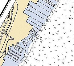
The Coast and Shoreline Change Analysis Program, a special NGS project, analyzes shoreline changes by comparing recent high-resolution satellite imagery or high-altitude reconnaissance aerial photography with existing NOAA nautical charts. By digitally overlaying the satellite imagery with charts, changes in shoreline features (piers, bulkheads, shoreline configuration, jetties, groins, etc.) can be easily detected. Shoreline changes are used to aid updating nautical charts.
|
|
|||||||||||||||||||||||||


- NOS Program Offices
- Center for Operational Oceanographic Products and Services
- National Centers for Coastal Ocean Science
- NOAA Coastal Services Center
- National Geodetic Survey
- Office of Coast Survey
- Office of National Marine Sanctuaries
- Office of Ocean and Coastal Resource Management
- Office of Response and Restoration

Revised August 23, 2007
| Questions, Comments? Contact Us | Report
Error | Disclaimer | About
the Site | User Survey
National Oceanic and Atmospheric
Administration | U.S.
Department of Commerce | USA.gov
http://oceanservice.noaa.gov/topics/navops/mapping/welcome.html