 |
|
|
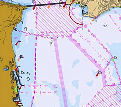
Nautical charts portray the fundamental elements necessary to navigate in the marine environment. The Electronic Navigational Chart (above) is a "smart chart" that provides more information than a paper chart and greater accuracy.
|
 |
|
The Office of Coast Survey (OCS) is the nation's nautical chart maker. Established by President Thomas Jefferson in 1807, the Office of Coast Survey is the oldest U.S. scientific organization and has a long history of supporting and facilitating marine commerce. Today, it continues to promote safe navigation, meet the challenges of navigating larger ships and those that carry hazardous cargo, and provide data for geographic information system (GIS) analysis, coastal stewardship, management decisions, shoreline change analysis, and marine boundary issues.
OCS collects, manages, and compiles the data and information necessary to maintain the national suite of 1,000 nautical charts. In addition, OCS conducts hydrographic surveys that measure water depth and produces coastal maps and vector shoreline series and historic maps and charts. These products support commercial shipping, the fishing industry, U.S. Navy and Coast Guard operations, state and local governments, GIS users, and recreational boaters throughout the United States.
 |
|
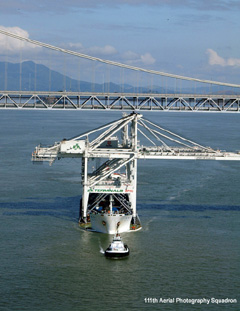
As margins of safety narrow, accurate, reliable, and up-to-date navigation information is critical (Photo Credit: 111th Aerial Photography Squadron).
|
|
|
NOAA nautical charts convey a variety of marine navigational data important to navigators. These data include the nature and form of the coast, the depths of the water and general character and configuration of the sea bottom, locations of dangers to navigation, the rise and fall of the tides, locations of human-made aids to navigation, and the characteristics of the Earth's magnetism. OCS relies heavily on other federal agencies to provide source information for nautical charts. In particular, the U.S. Coast Guard and the U.S. Army Corps of Engineers supply OCS with critical data on navigational aids and dredged channels.
The Coast Pilot is a series of nautical books that cover a variety of information important to navigators. The Coast Pilot is a fundamental tool for safe and efficient marine navigation. The series includes channel descriptions, anchorages, bridge and cable clearances, currents, tides and water levels, prominent features, weather, ice conditions, wharf descriptions, dangers, routes, traffic separation schemes, and small-craft facilities.
OCS also develops survey specifications and directs field programs implemented by ship- and shore-based survey units and contractors. Finally, OCS conducts development activities to improve the efficiency and productivity of data collection, chart compilation, and chart production.


