|
Hispanic Division: Back to Agricultural Settlements in Central California
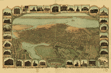
Bird's-Eye View of Oakland, CaliforniaOakland, the western terminus of the transcontinental railroad, became the hub of Portuguese settlement in central California. By the end of the nineteenth century, Portuguese coming from southern New England used the railroad, in contrast to the earlier immigrants, who came by whaling ships. Serving as the entrept for this migration, Oakland developed a sizeable Portuguese population, growing from 4,000 in 1892 to more than 12,000 in 1920. This 1900 bird's-eye view, which portrays Oakland's location on the east side of the San Francisco Bay, provides a panoramic perspective of the city when the Portuguese community was forming. The neighborhood in which the Portuguese first settled was located in the southwestern section (upper center), adjacent to the waterfront, where the railroads terminate.
Bird's-eye or panoramic views were a popular cartographic product published commercially during the last half of the nineteenth century and the first quarter of the twentieth century. They were usually commissioned by city fathers interested in promoting the commercial and industrial benefits of their particular location.
101 Independence Ave. SE Washington, D.C. 20540 |
SELECT FROM THE FOLLOWING: Bird's-Eye View of Oakland, California Portuguese Catholic Church in Oakland Aerial Perspective of the East Side of San Francisco Bay First Portuguese Mayor, San Leandro, California The Festival of the Holy Ghost in Santa Clara, California Agricultural Settlement in the San Joaquin Valley
|
