The Rapid City Flood of 1972
1972 Flash Flood Time Line
In a 6-hour time frame on June 9, 1972, a rush of water poured through the canyons and the city destroying homes, vehicles, businesses, bridges, and claiming 238 lives in Rapid City and the Black Hills.
June 9, 1972
Morning - The eastern slopes of the Black Hills are foggy and humid. Temperatures quickly rise through the 70s and into the 80s as steady east winds push moist air up against the Black Hills.
900 am MDT - The National Severe Local Storm Forecast Center (now known as the Storm Prediction Center) indicates the possibility of severe thunderstorms in western South Dakota during the late afternoon and evening.
1200 pm MDT - The afternoon forecast from the National Weather Service (NWS) calls for thunderstorms to develop over the Black Hills with some storms becoming severe.
Late morning - Towering cumulus clouds, precursors to thunderstorms, are seen over the hills west of Rapid City.
130 pm MDT - Early signs of convective cells building in northeastern Wyoming, about 60 miles northwest of Rapid City.
300 pm MDT - a line of thunderstorms develops to the southeast of Rapid City, moving west northwest.
340 pm MDT - Precipitation echoes are seen on Air Force radar and reported to the NWS.
500 pm MDT - Rain begins at Pactola Reservoir.
600 pm MDT - A nearly continuous line of thunderstorms covers the eastern slopes of the Black Hills. High water reported in Boulder Canyon between Sturgis and Deadwood and State Radio requested commercial radio and television stations announce motorists should avoid Boulder Canyon.
Data evaluation after the storm indicated the heaviest precipitation fell between Pactola Reservoir and Rapid City. Recording precipitation gages indicated the highest rainfall rates occurred between 6 PM and midnight.
615 pm MDT - WSO Rapid City called State Radio for reports and were told of a foot of water over roads near Sturgis.630 pm MDT - SDSM&T tells the NWS about strong thunderstorms in the Hermosa area. The Civil Defense Director for Pennington County reports 3 inches of rain at Pactola Dam.
650 pm MDT - Water over the road through Boulder Canyon. The radar operator at the South Dakota School of Mines and Technology (SDSM&T) estimates 2 inches of rain per hour have fallen in Boulder Canyon.
700 pm MDT - Report of 4 inches of rain in 2 hours near Galena (Lawrence County).
710 pm MDT - WSO Rapid City calls the River District Office in Sioux City, Iowa to tell them about the flash flood, relay precipitation reports and request guidance.
715 pm MDT - The NWS issues a flash flood warning for the northern Black Hills.
718 pm MDT - Sioux City River District Office contacts the Hydrologist in Charge at the River Forecast Center in Kansas City to relay information about the flash flood.
730 pm MDT - Mayor Don Barnett is notified of the flash flood warning and the National Guard and local law enforcement called to duty.
745 pm MDT - The National Weather Service River District Office in Sioux City, Iowa advises the NWS office in Rapid City to expand the warning southward to include Rapid City.
745 pm MDT - A person in Nemo contacts the NWS about Box Elder Creek being in flood and evacuations in low-lying areas of Nemo.
800 pm MDT - The expanded warning has been issued and the emergency operations center opens.
840 pm MDT - An observer at Ellsworth AFB reports heavy precipitation over the central Black Hills.
900 pm MDT - Commercial phone service becomes intermittent and unreliable.
930 pm MDT - NWS tells radio and television stations the heavy rain will continue until midnight.
1010 pm MDT - Evacuation of the Brookdale residential area (present Fairgrounds location) begins.
1015 pm MDT - Rapid Creek overtops its banks.
1030 pm MDT - In a television and radio broadcast, Mayor Don Barnett urges the evacuation of all low-lying areas.
1045 pm MDT - Canyon Lake Dam fails, adding to the flood waters. (Data from the gauge on Rapid Creek above Canyon Lake later reveals that from 900 pm MDT until the dam failed the water level rose approximately 12 feet).
June 10, 1972
1215 am MDT - A flood crest estimated at 50K cubic feet per second reaches downtown Rapid City.
500 am MDT - Rapid Creek is once again within its banks.
June 15, 1972
Housing and Urban Development (HUD) receives a grant request for $300,000 under the Neighborhood Development Plan.
June 18,1972
Similar weather conditions are developing and many people heed the evacuation notice. However, the winds accompanying this storm are stronger and no flooding develops.
June 20, 1972
Rapid City receives approval for the HUD Neighborhood Development Plan grant.
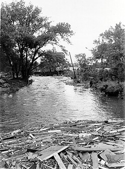 |
| Debris and damaged bridge, Rapid Creek (photo courtesy of the Journey Museum). |
August 24, 1972
Rapid City put in a new request for execution of the Conventional Urban Renewal Project, $48 million.
October 31, 1972
HUD approves $48 million for the Conventional Urban Renewal Project.
Flood Statistics
- Up to 15 inches of rain fell near Keystone, with an average of 10 inches over 60 square miles.
- The heaviest rainfall in Rapid City occurred between 1030 pm MDT (9th) and 1 am MDT.
- Peak flow on Rapid Creek 50,600 cubic feet per second...more than 10 times greater than the previous flood of record.
- During the flood, water rose as fast as 3.5 feet in 15 minutes
- Flood debris clogged the Canyon Lake spillway and temporarily raised the pool 11 to 12 feet deeper than normal.
- 238 people killed, 8 of the deaths in Keystone.
- 3,000 people injured.
- 1,335 homes destroyed.
- 5,000 automobiles destroyed.
- $160 million in total damages (1972 dollars, $644 million in 2002 dollars)
- 15 of the 23 bridges over Rapid Creek were destroyed.
- 754 acres were developed as a floodway.