November 1, 2000 Heavy Snow
A major winter storm dumped up to 54 inches of snow on portions of northeast Wyoming and western South Dakota. The snow started around midnight, early Wednesday morning. It snowed for about 15 hours. The full size image below depicts updated Preliminary Snowfall Totals.

Narrative
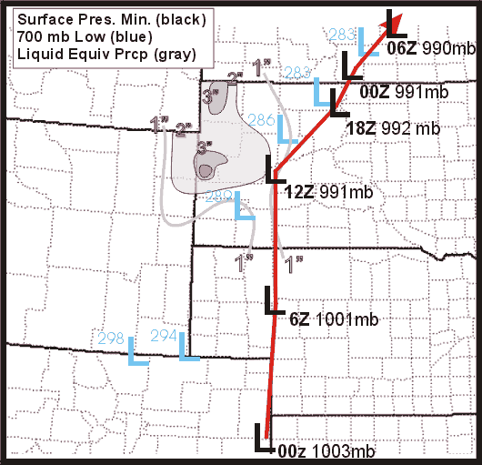
Late in the evening of Halloween night (Oct 31st) a very strong and relatively warm "Spring"-like storm moved north from eastern Colorado into western South Dakota. The effects of this large system were far-reaching, ranging from severe thunderstorms and tornadoes in Kansas, central Nebraska and south central North Dakota, to extremely heavy snowfall and blizzard conditions in Extreme western South Dakota, northeast Wyoming, and along the Montana - North Dakota border. In addition to the severe thunderstorms, heavy rain and snow, this event also brought very strong winds to western South Dakota, gusting up to 70 mph at Ellsworth Air Force Base (image on right).
Rain first moved into southwest South Dakota around 5 PM on October 31st. This area of moderate rain rapidly moved to the north, and covered much of western South Dakota by 8 PM. The rain changed to snow almost immediately over the highest elevations of the Black Hills. The snow level slowly lowered through the night, with rain changing to snow in Deadwood around 10 PM, and in Spearfish early Wednesday morning, November 1st. By early in the morning, nearly a foot of snow had already accumulated high in some areas of the Black Hills. As this large storm system slowly moved from south to north through western South Dakota during the day of November 1, a wide band of moderate to heavy precipitation wrapped around the system and was focused across northwest and west-central South Dakota. At elevations above 4000 feet, much of this precipitation was in the form of snow. Rain predominately fell at elevations below 3500 feet. Very heavy amounts of precipitation were recorded, with 2-4" of rain over much of northwest South Dakota and extreme northeast Wyoming, and greater than 30" of snow in parts of the northern Black Hills and Bear Lodge Mountains. Strong winds whipped across the area much of the day, with wind gusts in excess of 50 mph in many areas. The combination of heavy snow, very strong winds, and large snow drifts closed Interstate 90 from Moorecroft WY to Spearfish SD Nov 1st through the morning of Nov 2nd.
The image below is an outline of the heavy snow as seen by satellite on November 3rd, 2000. Snow on the ground is highlighted in yellow and matches the snowfall reports we received on the 1st of November.

By the evening of Nov 1st, the storm and much of the precipitation had moved north of South Dakota. Strong winds, however, continued to blow across the state for much of the night. Light upslope snow also continued over the Black Hills, accounting for a couple more inches of snow accumulation.
We have a radar loop (long to load) available for you to look at. It shows the rain and snow falling over the area from the radar near Rapid City, SD.
Sequence of Events
- Sunday, October 29th, 3:00 PM - Winter Storm Outlook issued for the potential snowstorm mid-week
- Monday, October 30th, 3:05 PM - Winter Storm Storm Watch issued for the potential snowstorm on late Tuesday night and Wednesday
- Tuesday, October 31st, 4:02 AM - Winter Storm Warnings issued for the snowstorm Tuesday night and Wednesday
- Wednesday, November 1st, 8:09 PM - All warnings cancelled