click on image above to view a larger version
|
 click on image above for a larger view
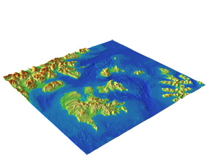
The combined bathymetric-topographic digital elevation models (DEMs) cover the Shumagin Islands region of the Aleutian Chain including the coastal community of Sand Point, Alaska. NGDC has developed a 3 arc-second DEM covering the entire region of the Shumagin Islands within the coordinate boundaries 161.0°W to 159.8°W; 54.7°N to 55.7°N and a 1/3 arc second DEM within coordinate boundaries 161.0°W to 159.8°W; 55.05°N to 55.7°N.
|