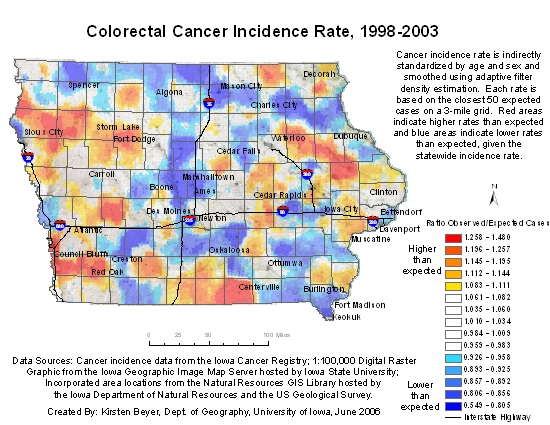
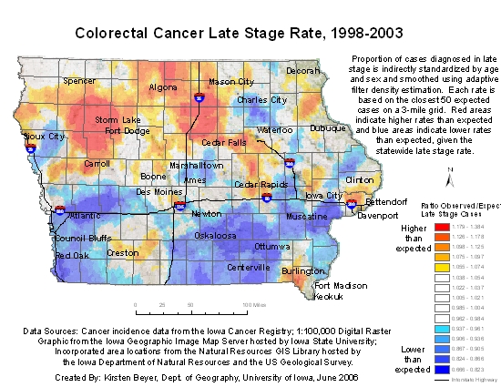
Colorectal Cancer Incidence and Late Stage Maps of Iowa
Each pair of maps that follow illustrates how different spatial units can convey different spatial patterns even when they are constructed from the same data source. The first map of each pair aggregates Iowa cancer registry data by county of residence and directly maps the ratio of age-adjusted number of cancers for the county / age-adjusted expected number of incidences in the county. The second map of each pair—the spatially smoothed map—aggregates Iowa cancer registry data by groups of ZIPcodes that together have at least 50 age-adjusted expected number of cancer incidences and maps the same ratio as defined above. These groups are defined as the closest ZIPcodes from each point on a three mile grid that meet the at-least 50 expected cancer cases limit.
For the late-stage map pair, the same method is used as above and the ratios mapped are the observed late-stage incidences / all stage incidences.
The smoothed maps give more geographic detail and a more reliable measure of cancer rates than the county maps because they use measures of the rates for approximately 2000 different areas—compared with 99 separate county rates and they use approximately the same number of expected cancer cases in each measure—compared with vastly different numbers of expected cases in the counties. The authors of these maps believe that smoothed maps constructed in this way are superior for the purpose of cancer control and prevention activities especially when used at local levels.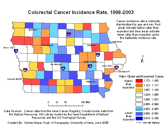
Click map to go to the Welcome to the Iowa Consortium for Comprehensive Cancer Control Cancer Maps Site
Click map to go to the Welcome to the Iowa Consortium for Comprehensive Cancer Control Cancer Maps Site

Click map to go to the Welcome to the Iowa Consortium for Comprehensive Cancer Control Cancer Maps Site
Click map to go to the Welcome to the Iowa Consortium for Comprehensive Cancer Control Cancer Maps Site
Organizations: The Department of Geography, The University of Iowa, made the maps under contract to the Comprehensive Cancer Control Program, Iowa Department of Public Health.
Contact Information:
1. Gerard Rushton, Department of Geography, 316 J.H.,
The University of Iowa, Iowa City, IA 52242. (319-335-0162); Gerard-rushton@uiowa.edu
2. Holly Smith, Program Coordinator, Comprehensive Cancer Control Program, Iowa Department of Public Health, Lucas State Office Building, 321 East 12th Street,
Des Moines, IA 50319, 515.281.0925, fax.515.281.6475, hsmith@idph.state.ia.us
Web address: www.uiowa.edu/~gishlth/ICCCCMaps
* Links to non-Federal organizations found at this site are provided solely as a service to our users. These links do not constitute an endorsement of these organizations or their programs by CDC or the Federal Government, and none should be inferred. CDC is not responsible for the content of the individual organization Web pages found at these links.