
 Bruce Richmond, Ann Gibbs, and others
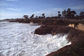
During late January and early February of 1998, the California Coast was hit by a series of powerful El Niño winter storms. At least 27 counties in California were declared National Disaster Areas, with hundreds of millions of dollars in property losses. Large waves, which coincided with high tides and elevated sea levels, produced severe beach erosion.
USGS researchers and students from University of California at Santa Cruz have been conducting beach surveys and monitoring changes in coastal morphology since early October 1997. Up to 4 meters of vertical beach loss was measured on several Monterey Bay beaches between October and mid-February and many beaches were completely submerged during high tides. Historical structures that had been buried since 1983, such as wharf pilings, old seawalls, and trolley car trestles, became emergent on several Monterey Bay beaches.
Coastal protection structures emplaced following the 1982-83 El Niño winter were mostly successful in mitigating coastal property loss due to wave attack and inundation. Most property damage was the result of the high rainfall amounts which caused flooding and landslides.
| Click on a beach name to see a series of
photographs taken from October '97 - February '98 |
Location Map |
||
For further information, contact Bruce Richmond
Accessibility | FOIA | Privacy | Policies and Notices
U.S. Department of the Interior U.S. Geological Survey
URL: http://walrus.wr.usgs.gov/elnino/coastal/
Last modified: 7 August 1999 (lzt)
Contact: El Niño Web Team