
Home
Final Environmental Impact Statement
Press Kit
Press Releases & Notices
Links to Sanctuary Websites
Frequently Asked Questions
Archived Documents
Joint Management Plan Press Kit
This web page contains public domain maps and images for free download and use by the media. The map and photo files are grouped by marine sanctuary, with the exception of the Tri-Sanctuary map, which stands alone and depicts the boundaries of all three central California national marine sanctuaries plus the new Davidson Seamount addition to the Monterey Bay National Marine Sanctuary. All maps and photos should be credited to "NOAA", except photos for Davidson Seamount should be jointly credited to "NOAA & MBARI".
| Cordell Bank | Gulf of the Farallones | Monterey Bay |
| Map of CBNMS, GFNMS & MBNMS | |||||
 |
|||||
| 4.3MB JPEG 1996 x 2741 |
|||||
| Cordell Bank | |||||
 |
 |
 |
 |
||
| Sooty Shearwater | Researchers using Remotely Operated Vehicle at Cordell Bank | Rosy Rockfish on Cordell Bank |
Black-footed Albatross landing at Cordell Bank |
||
| 888KB JPEG 1200 x 935 |
1MB JPEG 1152 x 1728 |
4.9MB JPEG 2560 x 1920 |
384KB JPEG 2396 x 1316 |
||
 |
 |
||||
| Pacific White Sided Dolphins | Humpback Whale Breaching | ||||
| 1.3MB JPEG 3072 x 2048 |
196KB JPEG 1075 x 717 |
||||
|
|||||
| Gulf of the Farallones | |||||
 |
 |
||||
| Blue Whales in the GFNMS | Humpback Whales Lunge Feeding in GFNMS | ||||
| 3.8MB JPEG 2955 x 1951 |
440KB JPEG 1694 x 968 |
||||
|
|||||
| Monterey Bay | |||||
|
|||||
 |
 |
 |
 |
||
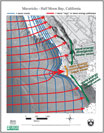
| Map & Info Plate of Davidson Seamount | Map of Davidson Seamount | Map of Bathymetry at Maverick's | Map of MPCW Zones at Maverick's | ||
| 2.6MB JPEG 3300 x 2550 |
2.3MB JPEG 3300 x 2550 |
752KB PDF* 2497 x 3201 |
1.8MB JPEG 2550 x 3300 |
||
 |
 |
 |
 |
||
| Map of Wave Energy at Maverick's | Map of Dredge Zones in MBNMS | Map of MPWC in MBNMS | Boundary Map for Santa Cruz | ||
| 92KB PDF* 2438 x 3123 |
156KB JPEG 567 x 763 |
1.4MB JPEG 2550 x 3300 |
512KB JPEG 700 x 599 |
||
|
|||||
|
|||||
 |
 |
 |
 |
||
| Blob Sulpin & Sponges at Davidson Seamount CREDIT: MBARI/MBNMS |
Bubble Gum Coral on Davidson Seamount CREDIT: MBARI/MBNMS |
Bubble Gum Coral on Davidson Seamount CREDIT: MBARI/MBNMS |
Flytrap Amemone on Davidson Seamount CREDIT: MBARI/MBNMS |
||
| 1.9MB JPEG 2048 x 1536 |
396KB JPEG 1200 x 900 |
316KB JPEG 1200 x 900 |
1004KB JPEG 2048 x 1536 |
||
 |
 |
 |
 |
||
| Mystery Mullusc at Davidson Seamount CREDIT: MBARI/MBNMS |
Octopus & Corals Davidson Seamount CREDIT: MBARI/MBNMS |
Octopus & Crinoid Davidson Seamount CREDIT: MBARI/MBNMS |
Crab on Sponge on Davidson Seamount CREDIT: MBARI/MBNMS |
||
| 840KB JPEG 2048 x 1536 |
1MB JPEG 2048 x 1536 |
1MB JPEG 2048 x 1536 |
1.1MB JPEG 2048 x 1536 |
||
 |
 |
 |
 |
||
| White Sponges on Davidson Seamount CREDIT: MBARI/MBNMS |
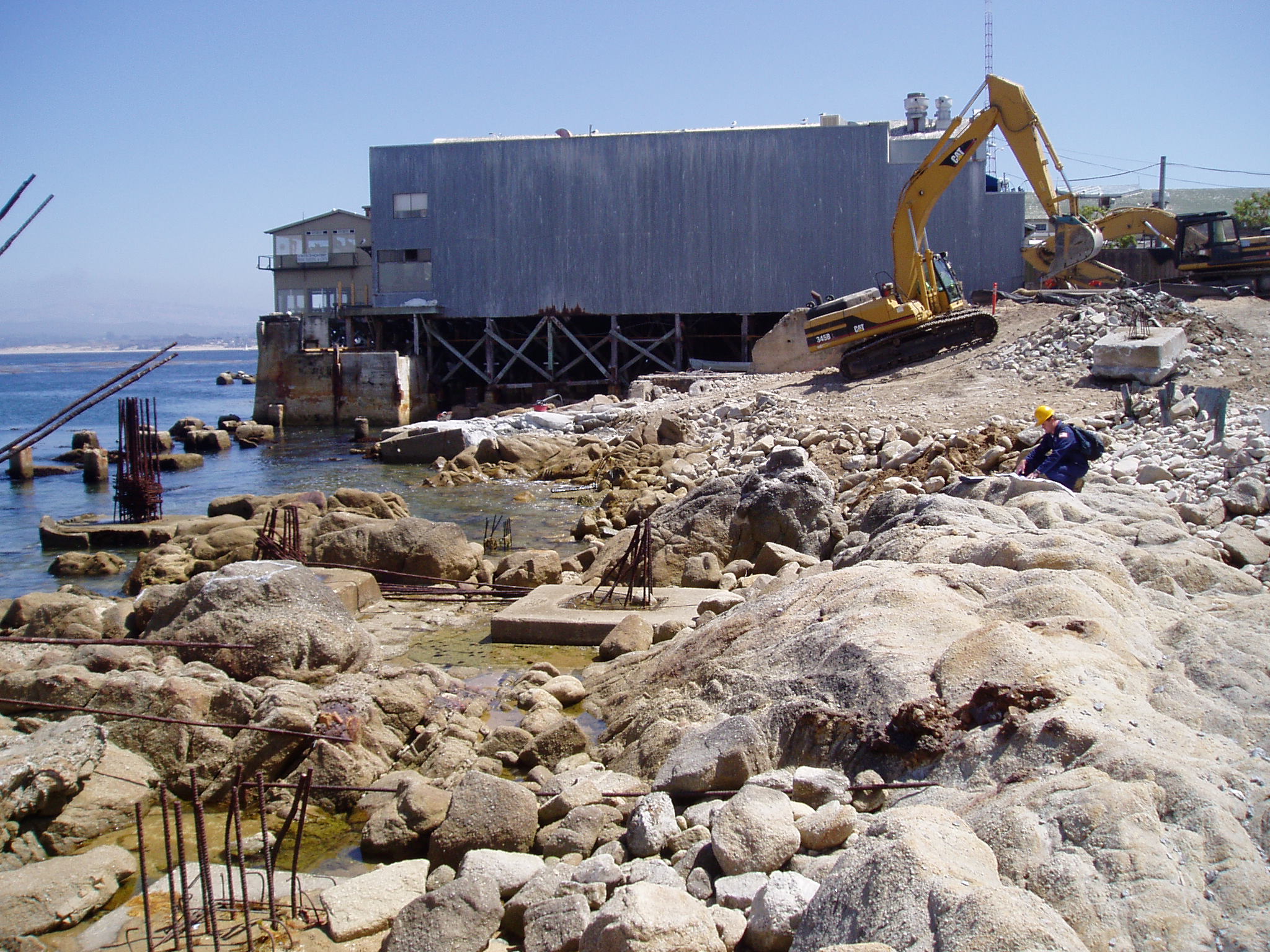
Coastal Construction in MBNMS | Cruise Ship MERCURY in MBNMS | Dredging Operations in Santa Cruz | ||
| 1MB JPEG 2048 x 1536 |
692KB JPEG 2048 x 1536 |
2.1MB JPEG 2560 x 1920 |
668MB JPEG 2048 x 1536 |
||
|
|||||
 |
 |
 |
 |
||
| Wolf Ell in MBNMS | Seastars & Anemones in MBNMS | Elephant Seal | Orca in MBNMS | ||
| 1.4MB JPEG 1600 x 1067 |
904KB JPEG 2272 x 1704 |
516KB JPEG 1200 x 798 |
400KB JPEG 800 x 544 |
||
 |
 |
 |
 |
||
| Pacific White Sided Dolphins in MBNMS | Maverick's from north of Pillar Point | MPWC Zone Boundary Buoy in MBNMS | Scoping Meetings for MBNMS Management Plan | ||
| 1.5MB JPEG 1600 x 1067 |
508KB JPEG 1800 x 1200 |
668KB JPEG 2048 x 1536 |
412KB JPEG 1760 x 1168 |
||
 |
 |
 |
 |
||
| Scoping Meetings for MBNMS Management Plan | Pelicans & Cormorants | Sanderlings | Agriculture Fields & Monterey Bay | ||
| 404KB JPEG 1760 1168 |
1.5MB JPEG 1600 x 1065 |
424KB JPEG 1280 x 960 |
1.5MB JPEG 3072 x 2048 |
||
 |
 |
 |
|||
| Big Sur Coastline | Wheelhouse & Debris of Grounded Vessel | Grounded Vessel on Rocks | |||
| 376KB JPEG 1800 x 1200 |
160KB JPEG 768 x 512 |
104KB JPEG 997 x 557 |
|||
|
|||||
*Some browsers have trouble rendering PDF files. If you are having troubles, please Right-Click (Windows/Mac) or Control-Click (Mac) to download and save the file to your desktop.
PDF files can be viewed and printed with the Free Acrobat Reader software that you can download at the Adobe website.
![]()