Descriptive Model of the July 17, 1998 Papua New Guinea Tsunami
ContentsRelated Publications
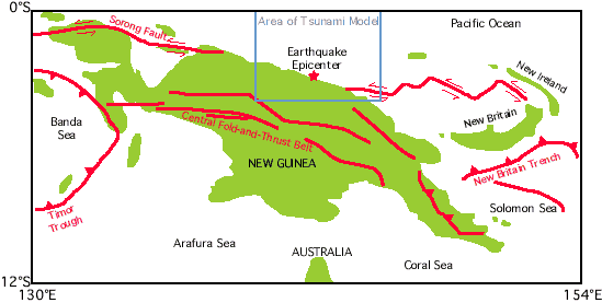
BackgroundThe tsunami that struck New Guinea on July 17, 1998 was the most devastating tsunami since the 1976 Moro Gulf, Philippines, tsunami and may surpass that event (Lockridge and Smith, 1984; Satake and Imamura, 1995). The high reported runups and the tremendous loss of life are of great concern to all, including the international scientific community. Scientists will closely examine this event in the coming months, in the ultimate hope of mitigating such disasters in the future. New Guinea is a seismically active region, the site of an arc-continent collision, where tectonic plates are converging and sliding past each other. The tectonic boundaries and faulting in this region are very complex, as shown below.
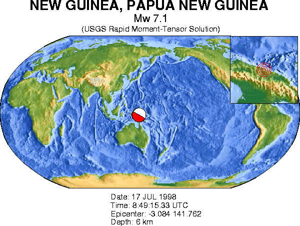
Figure modified from Abers and McCaffrey (1988) A comprehensive discussion and listing of historical earthquakes and tsunamis in the region can be found at the Russian Academy of Sciences' Tsunami Laboratory and in an article by Everingham (1974). The EarthquakeThe recorded magnitude of the earthquake was 7.1, and the epicenter was located in northern New Guinea near the coast. The fault mechanism from the National Earthquake Information Center (NEIC) shown by the red-and-white ball indicates that the earthquake could have occurred as uplift on a vertical fault or sliding on a horizontal fault. The inset in the upper right corner of the figure shows the location of the epicenter.
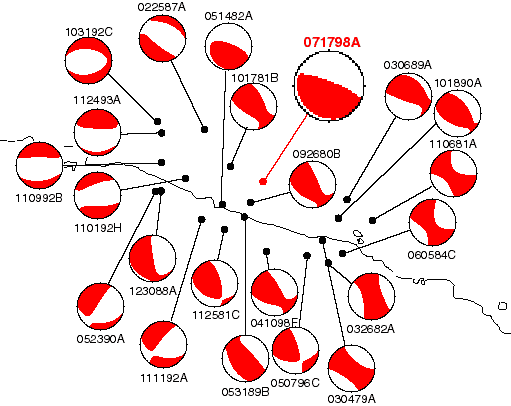
The source mechanisms for previous shallow earthquakes in the region (below) display a remarkable diversity in the type of faulting. (Click here for an explanation of "beachball" diagrams.) Near the July 17, 1998 event, however, most of the events are along steeply dipping reverse faults. Note the similarity in mechanism between the 5/14/82 event and the 7/17/98 event. Mechanisms to the south and east are mostly strike-slip events, whereas mechanisms to the west are mostly normal faulting events.
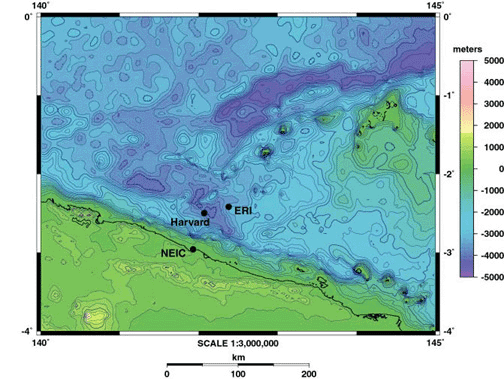
Earthquakes from the Harvard CMT catalog shallower than 30 km in the vicinity of the July 17, 1998 event. Note that the location of the July 17, 1998 event determined by the Harvard CMT group differs from the NEIC location above. Earthquakes occurred between 3/4/79 and 7/17/98 and ranged in magnitude between 5.1 and 7.1, the largest being the July 17, 1998 event. BathymetryThe bathymetry indicates that just offshore of the northern coast of New Guinea there is very steep and linear slope. It is possible that the relatively deep water near shore contributed to the unusual height of this tsunami. Shown below is the bathymetry in the region contoured at 200 m intervals from the 2-minute bathymetric data of Smith and Sandwell (1997) Copyright.
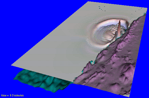
In the above figure, black circles indicate locations for the earthquake determined by the NEIC, Harvard, and the Earthquake Research Institute (ERI) at the University of Tokyo. Formal Metadata for this Figure The TsunamiAt present, too little is known about the July 17, 1998 earthquake and about the distribution of runup to formulate a quantitative model of the tsunami. The reported runups are unusually large for an earthquake of magnitude 7.1 (cf. Geist, 1998). Below, a descriptive or qualitative simulation of the tsunami is computed by making several assumptions about the source parameters of the earthquake. The model is for descriptive purposes only—a quantitative model awaits more information on the exact location of the earthquake and accurate measurements of runup. Of equal importance, the grid size used in this simulation is quite large and does not capture the nearshore behavior of the tsunami (cf. Titov and Synolakis, 1997). A full description of the assumptions and specifications of this model is listed in a separate page. About the AnimationThe animation shows how the July 17 tsunami might have looked from a vantage point above Papua New Guinea. The coastline shown in the animation is about 550 kilometers (340 miles) long. The animation begins with the initial wave—which formed almost simultaneously with the earthquake that triggered the event—and shows how the initial wave was reflected from the island. Note other waves traveling east and west along the coast." This animation does not show runup—the maximum elevation the water reached as it rose above the shoreline. Based on very preliminary data, this animation is a "descriptive model" of the tsunami. A more accurate simulation, or "quantitative model", can be developed when accurate measurements of the runup and more information about the earthquake that triggered the tsunami become available. Tsunami animations are available to view in three resolutions. Click below for your choice. In your browser, click or double click on the movie to run. Please note that for display purposes, the tsunami wave heights are greatly exaggerated with respect to the bathymetry. Low Resolution Movie, 431x301 pixels Medium Resolution Movie, 431x301 pixels High Resolution Movie, 431x301 pixels Although these animations graphically indicate the evolution of this tsunami, the simulated offshore wave heights are much less than the reported runups. Among international scientists, more highly refined models will be developed on the basis of higher resolution bathymetry, measured runup and inundation distributions, seismic source models, and more accurate representation of the hydrodynamics. As these models are developed and come online, links will be reported here. Waveform modeling and comparison with observed records of the tsunami VRML Model of Initial TsunamiVRML model of the initial tsunami with 8 predefined viewpoints updated 3/12/99 NOTE: VRML model requires a compatible VRML 2.0 plugin. More Information About the Papua New Guinea Tsunami
References CitedAbers, G., and R. McCaffrey, 1988. Active deformation in the New Guinea fold-and-thrust belt: Seismological evidence for strike-slip faulting and basement-involved thrusting, J. Geophys. Res., v. 93, p. 13,332-13,354. Everingham, I.B., 1974. Large earthquakes in the New Guinea-Solomon Islands area, 1873-1972, Tectonophysics, v. 23, p. 322-338. Geist, E. L., 1998. Local tsunamis and earthquake source parameters, Advances in Geophysics, v. 39, p. 117-209. Lockridge, P. A., and R. H. Smith, 1984. Tsunamis in the Pacific Basin, 1900-1983. National Geophysical Data Center, Boulder, Colorado. Scale 1:17,000,000. Smith, W. H. F., and Sandwell, D. T., Science, v. 277, p. 1956. Satake, K., and F. Imamura, 1995. Tsunamis 1992-1994. Pure and Applied Geophysics, v. 144, p. 373-379. Titov, V. V., and C. E. Synolakis, 1997. Extreme inundation flows during the Hokkaido-Nansei-Oki tsunami, Geophys. Res. Lett, v. 24, p. 1315-1318. Please note that some U.S. Geological Survey (USGS) information accessed through this page may be preliminary in nature and presented prior to final review and approval by the Director of the USGS. This information is provided with the understanding that it is not guaranteed to be correct or complete and conclusions drawn from such information are the sole responsibility of the user.
|
 Tsunamis & Earthquakes |
|||||||
|
||||||||

![]() U.S. Department of the Interior | U.S. Geological Survey
U.S. Department of the Interior | U.S. Geological Survey
URL: http://walrus.wr.usgs.gov/tsunami/PNG.html
Page Contact Information: Laura Zink Torresan
Page Last Modified: 22 October 2008 (lzt)