
- HOME
- EXPLORE
- Oceans
- Coasts
- Coastal Decision-making Tools
- Coastal Ecosystem Science
- Coastal Zone Management
- Coastal Monitoring and Observations
- Contaminants in the Environment
- Ecological Forecasting
- Harmful Algal Blooms
- National Estuarine Research Reserves
- Natural Hazards Assessment
- Natural Resource Restoration
- Training and Capacity- Building
- Charting and Navigation
- EDUCATION
- DATA EXPLORER
- NEWS
- OFFICES
- Center for Operational Oceanographic Products and Services
- International Program Office
- Management and Budget Office
- National Centers for Coastal Ocean Science
- National Geodetic Survey
- Office of National Marine Sanctuaries
- NOAA Coastal Services Center
- Office of Coast Survey
- Office of Ocean and Coastal Resources Management
- Office of Response and Restoration
- OUTREACH
- PUBLICATIONS
- WEB SITES
- ABOUT

|
|
August 2006 Feature: NERRS: Delivering Weather Data in Near-real-timeThe National Estuarine Research Reserve System is a network of protected areas established for long-term research, education, and stewardship. The reserve system, as part of its System-wide Monitoring Program, recently began delivering near-real-time weather and water quality data for the hurricane-prone areas of the Southeast U.S. and the Gulf of Mexico. These data, sent through the Geostationary Operational Environmental Satellites system, are a critical component of the Integrated Ocean Observing System.
Estuaries perform a vital function in mitigating the effects of major coastal storms on both human and natural communities. Their shallow waters buffer damaging wave energy before it reaches shore, and their grasses and mud flats can filter nutrients washing down rivers after heavy rains. To improve our ability to assess the impacts of coastal storms on estuarine ecosystems and coastal watersheds, the National Estuarine Research Reserve System (NERRS) has started delivering near-real-time weather data to weather forecasters from ten research reserves in the hurricane-prone regions of the Southeast U.S. and the Gulf of Mexico. The NERRS is a network of 27 reserves around the nation's coasts established for long-term monitoring, research, coastal stewardship, and education. This partnership program between NOAA and the coastal states protects more than 1.3 million acres of estuarine land and water and offers unique estuarine research, long-term monitoring, and education opportunities.
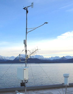
Near-real-time Data DeliveryThe near-real-time data are being collected at reserves in Mississippi, Alabama, Florida, Georgia, North and South Carolina, and Puerto Rico by weather stations already at each reserve. Each station records meteorological measurements of local temperature, wind speed and direction, relative humidity, barometric pressure, and rainfall. The stations are part of the System-wide Monitoring Program (SWMP) that has been collecting weather and water quality observations nationally since 1995.
Once collected, the data are uploaded to the Geostationary Operational Environmental Satellites system and transmitted to the National Weather Service's Hydrometeorological Automated Data System. Using state-of-the-art technology, data are collected every 15 minutes, transmitted hourly through satellites to direct and local readout ground stations, and can be viewed online within minutes of transmission. Observations from these estuaries are added to a menu of data available to forecasters that will enhance the accuracy of predictions of storms and storm tracks. These observations from hurricane-prone sites are just the beginning of the near-real-time delivery capabilities of the NERRS observing system.
Future Telemetry Efforts
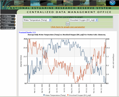
In developing the schedule for installing the near-real-time, or telemetry, capability this year, officials decided that the highest priority sites would be in states that are hurricane prone, to support management needs in those areas quickly and efficiently. The remaining reserves will be telemetered later in 2006, which will complete a national data delivery system consisting of 27 weather stations and at least 35 water quality sites in unique estuarine environments not well represented in the current weather observation system. By the end of 2006, all 27 reserves will have at least one weather station and one water quality station telemetered. These real-time data can be viewed on-line at http://cdmo.baruch.sc.edu/ in user-friendly formats, such as simulated thermometers and gauges. In addition, data can be graphed instantly through simple "point-and-click" applications that allow the user to select what to graph and what timeframe to use. For more rigorous data analysis, data can be downloaded easily and brought into standard software packages for manipulation, graphing, and statistical analysis.
SWMP & IOOSAs a backbone component of the Integrated Ocean Observing System (IOOS), the SWMP data from the estuarine reserves are an integral part of the national effort to use data to address societal needs, such as improving weather predictions, mitigating the effects of natural hazards, and protecting and restoring coastal marine ecosystems. The NERRS program, with its estuarine focus, offers a unique set of data to IOOS, collecting one of the only nation-wide coordinated sets of estuarine water quality and weather parameters, with real-time data capabilities growing every day.
Applying Real-time Data
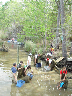
SWMP data have a wide range of applications. NERRS water quality, weather, and biological data are used not only by weather forecasters, but also by researchers, coastal managers, educators, and recreational users. SWMP tracks both short-term variability and long-term changes in estuaries and coastal systems. In addition to weather and water quality, the program is adding monitoring of biological indicators such as submerged and emergent aquatic vegetation as well as habitat change and watershed land use. The collected near-real-time data are particularly useful in the context of long-term monitoring. For example, researchers can compare the water temperature right now with temperatures collected over the last 10 years at the same location to see if today's temperature is an average or an extreme value. This type of information can help researchers to identify and understand observed changes and trends. Both the ten-year long-term data record and the real-time data are used in conjunction with NERRS biological monitoring data to evaluate habitat requirements of important estuarine species such as submerged aquatic vegetation (SAV). For example, water quality data on nutrients, turbidity, and salinity are used in SAV experiments and restoration projects. NERRS is developing a variety of Web products for data users such as students, teachers, coastal managers and coastal resource users such as fish harvesters and shellfish growers. In the mid-Atlantic and Pacific Northwest pilot projects are under way to conduct a needs assessment and develop Web tools tailored to these additional data users. NERRS also plans to develop on-line lesson plans and other Web tools that use data to teach science concepts.
ConclusionAlthough the SWMP was officially established in 1995, environmental monitoring has been part of NERRS for much of the system's over 30-year history. SWMP has given educators, students, and coastal managers access to a wealth of up-to-date estuarine water quality and weather data for use in coastal science curricula, coastal planning, resource management programs, and regulatory activities. Today, exciting advances within SWMP have the program poised to become a crucial piece of a national IOOS and to improve understanding, prediction, and response to the ways that estuarine ecosystems evolve in response to natural and human-induced perturbations. |
SWMP data have a wide range of applications.
...exciting advances within SWMP have the program poised to become a crucial piece of a national IOOS... |
||||||||||||||||||||||

- NOS Program Offices
- Center for Operational Oceanographic Products and Services
- National Centers for Coastal Ocean Science
- NOAA Coastal Services Center
- National Geodetic Survey
- Office of Coast Survey
- Office of National Marine Sanctuaries
- Office of Ocean and Coastal Resource Management
- Office of Response and Restoration

Revised September 25, 2007
| Questions, Comments? Contact Us | Report
Error | Disclaimer | About
the Site | User Survey
National Oceanic and Atmospheric
Administration | U.S.
Department of Commerce | USA.gov
http://oceanservice.noaa.gov/news/features/welcome.html