|
|
|
Metadata
|
|
ID
|
M-2-65-EG
|
|
Abstract
|
Chief Scientist: Gene Rusnak. Geological and Geophysical
data (bathymetry, gravitycore, Shipekgrab,
Dill-Moorevaneshear, Sonoprobe, sparker) of field activity
M-2-65-EG in Kings Bay area, Eastern Gulf of Alaska from
07/12/1965 to 07/17/1965
|
|
Project/Theme
|
Earthquake Hazards Project
|
|
Chief Scientist
|
Gene Rusnak
|
|
Activity Type
|
Geological and Geophysical
|
|
Platform
|
Don J. Miller II
|
|
Area of Operation
|
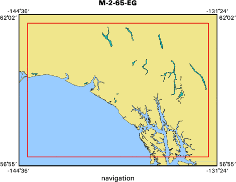
Kings Bay area, Eastern Gulf of Alaska
|
|
Location map
|
|
|
Bounding Coordinates
|
61.75000
-144.00000 -132.00000
57.25000
|
|
Dates
|
07/12/1965 (JD 193) to 07/17/1965 (JD 198)
|
|
Analog Materials
|
list
|
|
Index map
|
|
|
Crew
|
|
Gene Rusnak
|
Chief Scientist, USGS Western Region
|
|
|
Equipment Used
|
|
bathymetry
|
|
gravitycore
|
|
Shipekgrab
|
|
Dill-Moorevaneshear
|
|
Sonoprobe
|
|
sparker
|
|
|
Purpose
|
|
To obtain evidence from bathymetry,
|
|
subbottom profiling, sediment distribution, and related features
|
|
around the Prince William Sound area which could be ascribed to the
|
|
causes and the results of the devastation on the earthquake-affected
|
|
shores and seafloors following the 27 March 1964 Earthquake.
|
|
|
Information to be Derived
|
|
High energy subbottom profiling, sediment sampling, bathymetry.
|
|
|
Got Help?
|
For M-2-65-EG, we would appreciate any information on -- contract, days at sea, dive count, funding, information specialist, kms of navigation, national plan, NGDC Info, notes, organization, owner, ports, project number, publications, scanned materials, seismic description, station count, station description, submersible, summary, tabulated info.
|
|


