| Home >> | Advanced Search >> |
 |
|
Astronaut Photography of Earth - Display Record
ISS002-E-9309

Low-resolution Browse Image
(Most browse images are not color adjusted.)Images
Conditions for Use of Images >>Image Transformation Tutorial >> Saving, Color Adjusting, and Printing Images >>
Images to View on Your Computer Now
| File Name | File Size (bytes) | Width | Height | Annotated | Cropped | Purpose | Comments | |
|---|---|---|---|---|---|---|---|---|
| View | ISS002-E-9309_2.JPG | 32838 | 400 | 300 | Yes | Yes | Photographic Highlights | |
| View | ISS002-E-9309.JPG | 39100 | 540 | 405 | Yes | Yes | NASA's Earth Observatory web site | |
| View | ISS002-E-9309.JPG | 51933 | 540 | 533 | No | Yes | NASA's Earth Observatory web site | The northern tip was added from a map. |
| View | ISS002-E-9309.JPG | 58105 | 640 | 437 | No | No | ||
| View | ISS002-E-9309.JPG | 2451392 | 2249 | 1705 | No | No | NASA's Earth Observatory web site |
Large Images to Request for Downloading
| File Name | File Size (bytes) | Width | Height | Annotated | Cropped | Purpose | Comments | |
|---|---|---|---|---|---|---|---|---|
| Request | ISS002-E-9309.JPG | 1115346 | 3060 | 2092 | No | No | ||
| Request | ISS002-E-9309_2.JPG | 2451392 | 2249 | 1705 | No | Yes | Photographic Highlights |
Download a Keyhole Markup Language (KML) file for use in Google Earth.
Electronic Image Data
Camera Files >> No sound file available.Identification
Mission: ISS002 Roll: E Frame: 9309 Mission ID on the Film or image: ISS002Country or Geographic Name: LESSER ANTILLES
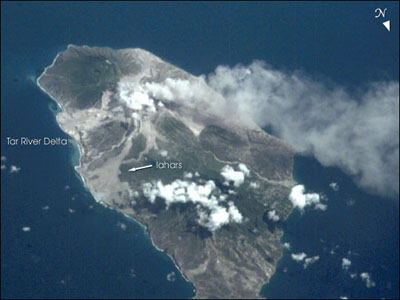
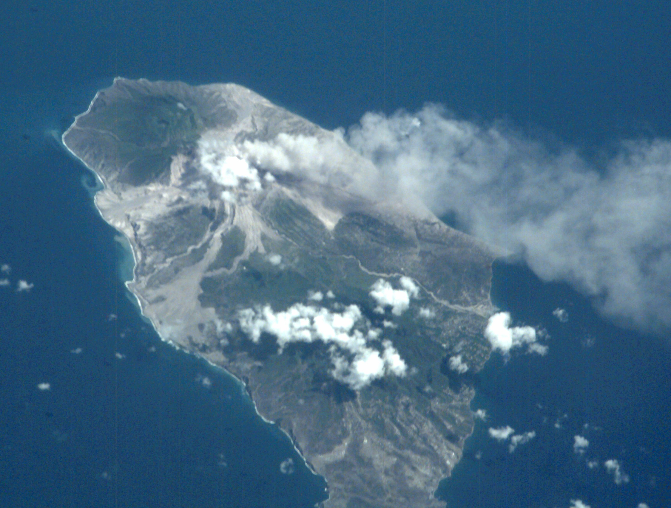
Features: MONTSERRAT, PLUME, LAHARS
Center Point Latitude: 16.5 Center Point Longitude: -62.0 (Negative numbers indicate south for latitude and west for longitude)
Stereo: (Yes indicates there is an adjacent picture of the same area)
ONC Map ID: JNC Map ID:
Camera
Camera Tilt: High ObliqueCamera Focal Length: 800mm
Camera: E2: Kodak DCS460 Electronic Still Camera
Film: 3060E : 3060 x 2036 pixel CCD, RGBG array.
Quality
Film Exposure:Percentage of Cloud Cover: 10 (0-10)
Nadir
Date: 20010709 (YYYYMMDD)GMT Time: 180000 (HHMMSS)Nadir Point Latitude: 21.9, Longitude: -61.7 (Negative numbers indicate south for latitude and west for longitude)
Nadir to Photo Center Direction: South
Sun Azimuth: 276 (Clockwise angle in degrees from north to the sun measured at the nadir point)
Spacecraft Altitude: 204 nautical miles (378 km)
Sun Elevation Angle: 65 (Angle in degrees between the horizon and the sun, measured at the nadir point)
Orbit Number: 3062
Captions
ISS002-E-9309 Montserrat, Lesser Antilles July 2001Volcanic activity on the West Indian island of Montserrat has remained high for several years—the current activity started in 1995. However, remote sensing of the island has been difficult because of frequent cloud cover. The International Space Station crew flew north of the island on a clear day in early July (July 9, 2001) and recorded a vigorous steam plume emanating from the summit of Soufriere Hills. The image also reveals the extensive volcanic mud flows (lahars) and new deltas built out from the coast from the large amounts of volcanic debris delivered downstream by the rivers draining the mountain. As a small island (only 13 x 8 km), all of Montserrat has been impacted by the eruptions.
Download Packaged File.
This option downloads the following items, packaged into a single file, if they are available:
- Browse image
- Cataloged information with captions
- Camera file
- Sound file
Server: 2 |
This service is provided by the International Space Station program. |
Recommended Citation: |
||

