| Home >> | Advanced Search >> |
 |
|
Astronaut Photography of Earth - Display Record
ISS014-E-8179
Low-resolution Browse Image
(Most browse images are not color adjusted.)Images
Conditions for Use of Images >>Image Transformation Tutorial >> Saving, Color Adjusting, and Printing Images >>
Images to View on Your Computer Now
| File Name | File Size (bytes) | Width | Height | Annotated | Cropped | Purpose | Comments | |
|---|---|---|---|---|---|---|---|---|
| View | ISS014-E-8179.JPG | 66469 | 639 | 435 | No | No | ||
| View | ISS014-E-8179.JPG | 251494 | 540 | 340 | Yes | Yes | NASA's Earth Observatory web site |
Large Images to Request for Downloading
| File Name | File Size (bytes) | Width | Height | Annotated | Cropped | Purpose | Comments | |
|---|---|---|---|---|---|---|---|---|
| Request | ISS014-E-8179.JPG | 707631 | 1000 | 629 | No | Yes | NASA's Earth Observatory web site | |
| Request | ISS014-E-8179.JPG | 926010 | 3032 | 2064 | No | No |
Download a Keyhole Markup Language (KML) file for use in Google Earth.
Electronic Image Data
Camera Files >> No sound file available.Identification
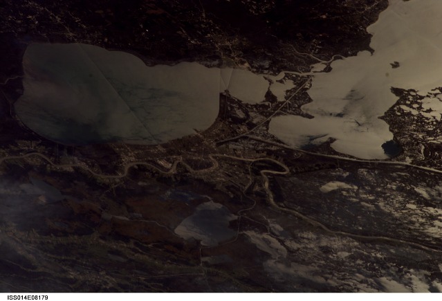
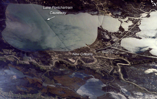
Mission: ISS014 Roll: E Frame: 8179 Mission ID on the Film or image: ISS014Country or Geographic Name: USA-LOUISIANA
Features: LAKE PONTCHARTRAIN,NEW ORLEANS
Center Point Latitude: 30.0 Center Point Longitude: -90.0 (Negative numbers indicate south for latitude and west for longitude)
Stereo: (Yes indicates there is an adjacent picture of the same area)
ONC Map ID: JNC Map ID:
Camera
Camera Tilt: High ObliqueCamera Focal Length: 180mm
Camera: E4: Kodak DCS760C Electronic Still Camera
Film: 3060E : 3060 x 2036 pixel CCD, RGBG array.
Quality
Film Exposure:Percentage of Cloud Cover: 10 (0-10)
Nadir
Date: 20061118 (YYYYMMDD)GMT Time: 191100 (HHMMSS)Nadir Point Latitude: 33.7, Longitude: -86.5 (Negative numbers indicate south for latitude and west for longitude)
Nadir to Photo Center Direction: Southwest
Sun Azimuth: 208 (Clockwise angle in degrees from north to the sun measured at the nadir point)
Spacecraft Altitude: 179 nautical miles (332 km)
Sun Elevation Angle: 32 (Angle in degrees between the horizon and the sun, measured at the nadir point)
Orbit Number: 1755
Captions
ISS014-E-08179 (18 Nov. 2006) --- New Orleans, Louisiana is featured in this image photographed by an Expedition 14 crewmember on the International Space Station. The location of New Orleans, in a shallow depression within unconsolidated deltaic sediments, makes it particularly vulnerable to subsidence and increased likelihood of flooding. The average elevation of metropolitan New Orleans is 1.8 meters below sea level, and a complicated system of levees, pumps, and upstream control structures on the Mississippi River is necessary to maintain dry conditions in the city. The ground subsidence occurs from groundwater withdrawal, reduction of sediment delivery by the Mississippi River, and land use changes (such as draining of wetlands) associated with continuing development. The low areas can be flooded by river floods, storm surges, or failure of levees holding back surrounding lake waters - as demonstrated catastrophically during Hurricane Katrina in 2005. Sunglint accentuates the wetland setting of New Orleans in this image by highlighting the numerous lakes, pond, and rivers (in various shades of silver-gray) surrounding the city. The view was acquired by a crewmember looking southwest from the station, which was located over north-central Alabama at the time this image was taken. Lake Pontchartrain borders New Orleans to the north, and the Lake Pontchartrain Causeway (36 kilometers in length) appears as a dark linear feature against the lake surface. Variations in surface water coloration to the east and west of the Causeway reflect the dynamics of the surface waters (including surface currents and wind-induced roughening). The patterns are made visible by the presence of surfactants on the water surface. Low cloud cover produces a blue-gray haze visible at lower left.Download Packaged File.
This option downloads the following items, packaged into a single file, if they are available:
- Browse image
- Cataloged information with captions
- Camera file
- Sound file
Server: 2 |
This service is provided by the International Space Station program. |
Recommended Citation: |
||

