| Home >> | Advanced Search >> |
 |
|
Astronaut Photography of Earth - Display Record
ISS014-E-8138

Low-resolution Browse Image
(Most browse images are not color adjusted.)Images
Conditions for Use of Images >>Image Transformation Tutorial >> Saving, Color Adjusting, and Printing Images >>
Images to View on Your Computer Now
| File Name | File Size (bytes) | Width | Height | Annotated | Cropped | Purpose | Comments | |
|---|---|---|---|---|---|---|---|---|
| View | ISS014-E-8138.JPG | 74813 | 639 | 435 | No | No | ||
| View | ISS014-E-8138.JPG | 305817 | 540 | 364 | Yes | Yes | NASA's Earth Observatory web site |
Large Images to Request for Downloading
| File Name | File Size (bytes) | Width | Height | Annotated | Cropped | Purpose | Comments | |
|---|---|---|---|---|---|---|---|---|
| Request | ISS014-E-8138.JPG | 930122 | 1000 | 674 | No | Yes | NASA's Earth Observatory web site | |
| Request | ISS014-E-8138.JPG | 1127680 | 3032 | 2064 | No | No |
Download a Keyhole Markup Language (KML) file for use in Google Earth.
Electronic Image Data
Camera Files >> No sound file available.Identification
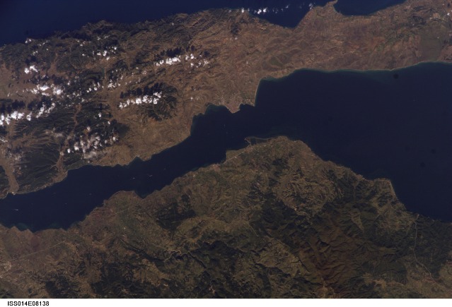
Mission: ISS014 Roll: E Frame: 8138 Mission ID on the Film or image: ISS014Country or Geographic Name: TURKEY
Features: GALLIPOLI,CANAKKALE STRAIT
Center Point Latitude: 40.4 Center Point Longitude: 26.7 (Negative numbers indicate south for latitude and west for longitude)
Stereo: (Yes indicates there is an adjacent picture of the same area)
ONC Map ID: JNC Map ID:
Camera
Camera Tilt: 11Camera Focal Length: 180mm
Camera: E4: Kodak DCS760C Electronic Still Camera
Film: 3060E : 3060 x 2036 pixel CCD, RGBG array.
Quality
Film Exposure:Percentage of Cloud Cover: 10 (0-10)
Nadir
Date: 20061109 (YYYYMMDD)GMT Time: 082318 (HHMMSS)Nadir Point Latitude: 40.4, Longitude: 27.3 (Negative numbers indicate south for latitude and west for longitude)
Nadir to Photo Center Direction: West
Sun Azimuth: 155 (Clockwise angle in degrees from north to the sun measured at the nadir point)
Spacecraft Altitude: 182 nautical miles (337 km)
Sun Elevation Angle: 29 (Angle in degrees between the horizon and the sun, measured at the nadir point)
Orbit Number: 1606
Captions
Gallipoli and Dardanelles Strait, Turkey:The city of Gallipoli (Gelibolu in Turkish) sits at a crossroads between the Marmara and Aegean Seas, connected by the Dardanelles Strait. The strait is a 61-kilometer-long drowned valley formed along a fault (fracture in Earth’s crust). The fracture formed as the Arabian, Indian, and African tectonic plates collided with the Eurasian plate during the Tertiary period, approximately 2-65 million years ago. This faulting created the rugged terrain of western Turkey visible in the lower half of this astronaut photograph, as well as the great mountain ranges of the Alps and Himalayas. Plate collision continues today as Turkey moves westward in relation to Eurasia. The movement leads to frequent strike-slip earthquakes (quakes in which the relative ground motion along the fault is forward or backward, rather than up or down.)
The urbanized area of modern Gallipoli is visible as a light gray to pink region at the entrance to the Dardanelles Strait. Water in the Strait flows in both northeast and southwest directions due to opposite surface and undercurrents. The Strait has a long history of strategic importance as it provides a conduit between the Mediterranean and Black Seas, as well as access to Ankara, Turkey’s capital, to the northeast (not shown). Several ships are visible in the Strait to the southwest of Gallipoli (image center left). The Battle of Gallipoli—part of an Allied plan to capture Istanbul, then the capital of the Ottoman Empire—was fought near the city during World War I.
Download Packaged File.
This option downloads the following items, packaged into a single file, if they are available:
- Browse image
- Cataloged information with captions
- Camera file
- Sound file
Server: 2 |
This service is provided by the International Space Station program. |
Recommended Citation: |
||

