| Home >> | Advanced Search >> |
 |
|
Astronaut Photography of Earth - Display Record
STS005-37-758
Low-resolution Browse Image
(Most browse images are not color adjusted.)Images
Conditions for Use of Images >>Image Transformation Tutorial >> Saving, Color Adjusting, and Printing Images >>
Images to View on Your Computer Now
| File Name | File Size (bytes) | Width | Height | Annotated | Cropped | Purpose | Comments | |
|---|---|---|---|---|---|---|---|---|
| View | STS005-37-758.JPG | 45993 | 640 | 480 | No | No | ISD 1 | |
| View | STS005-37-758.JPG | 68001 | 540 | 363 | Yes | Yes | NASA's Earth Observatory web site | |
| View | STS005-37-758.JPG | 7344809 | 2400 | 2418 | No | No | NASA's Earth Observatory web site |
Download a Keyhole Markup Language (KML) file for use in Google Earth.
Electronic Image Data
Camera files only apply to electronic still cameras.No sound file available.
Identification
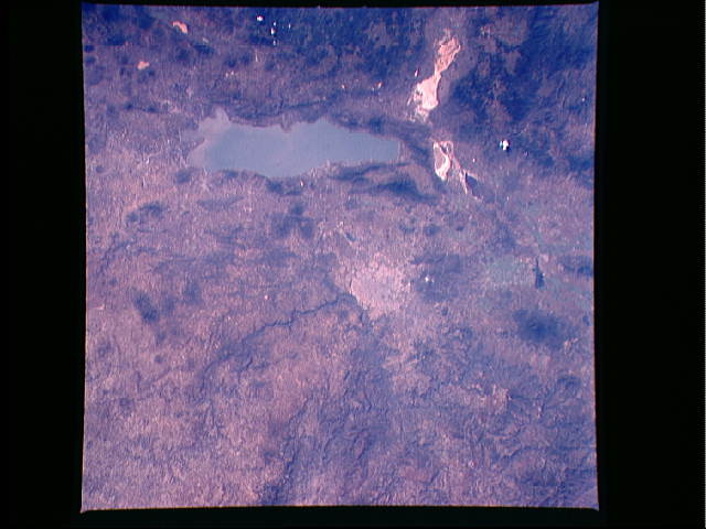
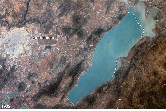
Mission: STS005 Roll: 37 Frame: 758 Mission ID on the Film or image: STS-5Country or Geographic Name: MEXICO
Features: GUADALAJARA, LAKE CHAPALA
Center Point Latitude: 20.6 Center Point Longitude: -103.2 (Negative numbers indicate south for latitude and west for longitude)
Stereo: No (Yes indicates there is an adjacent picture of the same area)
ONC Map ID: J24 JNC Map ID:
Camera
Camera Tilt: Near VerticalCamera Focal Length: 100mm
Camera: HB: Hasselblad
Film: 5017 : Kodak, natural color positive, Ektachrome, X Professional, ASA 64, standard base.
Quality
Film Exposure: NormalPercentage of Cloud Cover: 0 (0-10)
Nadir
Date: 198211__ (YYYYMMDD)GMT Time: (HHMMSS)Nadir Point Latitude: , Longitude: (Negative numbers indicate south for latitude and west for longitude)
Nadir to Photo Center Direction:
Sun Azimuth: (Clockwise angle in degrees from north to the sun measured at the nadir point)
Spacecraft Altitude: nautical miles (0 km)
Sun Elevation Angle: (Angle in degrees between the horizon and the sun, measured at the nadir point)
Orbit Number: 4
Captions
Lake Chapala, Mexico:Astronauts aboard the Space Shuttle and Space Station have tracked regional environmental changes spanning decades. Lake Chapala, Mexico’s largest lake, serves as one example of an area experiencing significant changes that have been well documented from space. Over the past twenty years, the lake’s water levels have decreased in conjunction with increasing development from the fast-growing city of Guadalajara.
Chapala is an alpine lake in west-central Mexico, resting at an elevation of 1,500 meters. It is part of the Lerma-Santiago River system, being fed mainly by the Lerma River on the east side of the lake and draining into the Rio Grande de Santiago from the northeast corner of the lake. The water then flows northwest into the Pacific Ocean. The combined effects of diminished inflow from dams on the Rio Lerma, heavy use of water for irrigation, and regional droughts in recent years have resulted in lower water levels in the lake. This is important to humans because it is the major water source for the nearby city of Guadalajara and its five million residents. Today, the mean depth of Lake Chapala is approximately 7 meters, with seasonal variations of water depth and clarity.
The lake is also a critical habitat for several species of migratory birds, such as the white pelican, and home to thousands of indigenous plants and animals. Untreated industrial and agricultural runoff threaten the health of this critical lake. The rapid development of the Lake Chapala region has spurred grassroots conservation programs to maintain the natural habitats of the lake and maintain a healthy ecotourism industry.
This image, taken in November 1982 from the Space Shuttle along with another one taken in April 2004 from the International Space Station (ISS009-E-5090), shows some of the coastline changes around the lake. In the 2004 image (ISS009-E-5090), sun glint reflecting off the water surface highlights the water-vegetation boundary of the coastal marshes that have emerged with lower lake levels. Their estimated locations are annotated on the 1985 image as dashed lines—roughly following the boundary of more turbid water. The built-up area of Guadalajara has also expanded from the 1982 baseline.
Download Packaged File.
This option downloads the following items, packaged into a single file, if they are available:
- Browse image
- Cataloged information with captions
- Camera file
- Sound file
Server: 2 |
This service is provided by the International Space Station program. |
Recommended Citation: |
||

