| Home >> | Advanced Search >> |
 |
|
Astronaut Photography of Earth - Display Record
ISS001-E-6283

Low-resolution Browse Image
(Most browse images are not color adjusted.)Images
Conditions for Use of Images >>Image Transformation Tutorial >> Saving, Color Adjusting, and Printing Images >>
Images to View on Your Computer Now
| File Name | File Size (bytes) | Width | Height | Annotated | Cropped | Purpose | Comments | |
|---|---|---|---|---|---|---|---|---|
| View | ISS001-E-6283.JPG | 92082 | 540 | 450 | Yes | Yes | NASA's Earth Observatory web site | |
| View | ISS001-E-6283.JPG | 164895 | 640 | 437 | No | No | ||
| View | ISS001-E-6283_2.JPG | 172672 | 400 | 266 | No | No | Photographic Highlights | |
| View | ISS001-E-6283.JPG | 377142 | 1200 | 820 | No | No | Cities collection | |
| View | ISS001-E-6283.JPG | 3515749 | 3060 | 2092 | No | No | NASA's Earth Observatory web site | |
| View | ISS001-E-6283.JPG | 3515749 | 3060 | 2092 | No | No | Cities collection |
Large Images to Request for Downloading
| File Name | File Size (bytes) | Width | Height | Annotated | Cropped | Purpose | Comments | |
|---|---|---|---|---|---|---|---|---|
| Request | ISS001-E-6283.JPG | 3515749 | 3060 | 2092 | No | No | NASA's Earth Observatory web site | |
| Request | ISS001-E-6283.JPG | 3515749 | 3060 | 2092 | No | No | ||
| Request | ISS001-E-6283.TIF | 19211036 | 3060 | 2092 | No | No |
Download a Keyhole Markup Language (KML) file for use in Google Earth.
Electronic Image Data
Camera Files >> No sound file available.Identification
Mission: ISS001 Roll: E Frame: 6283 Mission ID on the Film or image: ISS01Country or Geographic Name: USA-TEXAS
Features: HOUSTON, DOWNTOWN AREA
Center Point Latitude: 29.5 Center Point Longitude: -95.5 (Negative numbers indicate south for latitude and west for longitude)
Stereo: (Yes indicates there is an adjacent picture of the same area)
ONC Map ID: JNC Map ID:
Camera
Camera Tilt: 12Camera Focal Length: 400mm
Camera: E2: Kodak DCS460 Electronic Still Camera
Film: 3060E : 3060 x 2036 pixel CCD, RGBG array.
Quality
Film Exposure:Percentage of Cloud Cover: 10 (0-10)
Nadir
Date: 20001217 (YYYYMMDD)GMT Time: 213045 (HHMMSS)Nadir Point Latitude: 30.2, Longitude: -95.6 (Negative numbers indicate south for latitude and west for longitude)
Nadir to Photo Center Direction: South
Sun Azimuth: 226 (Clockwise angle in degrees from north to the sun measured at the nadir point)
Spacecraft Altitude: 201 nautical miles (372 km)
Sun Elevation Angle: 19 (Angle in degrees between the horizon and the sun, measured at the nadir point)
Orbit Number: 3873
Captions
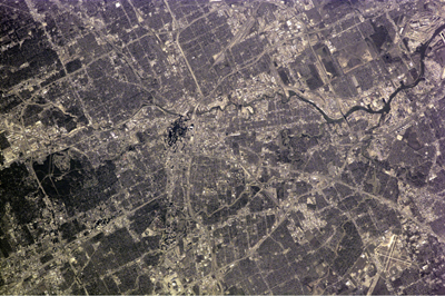
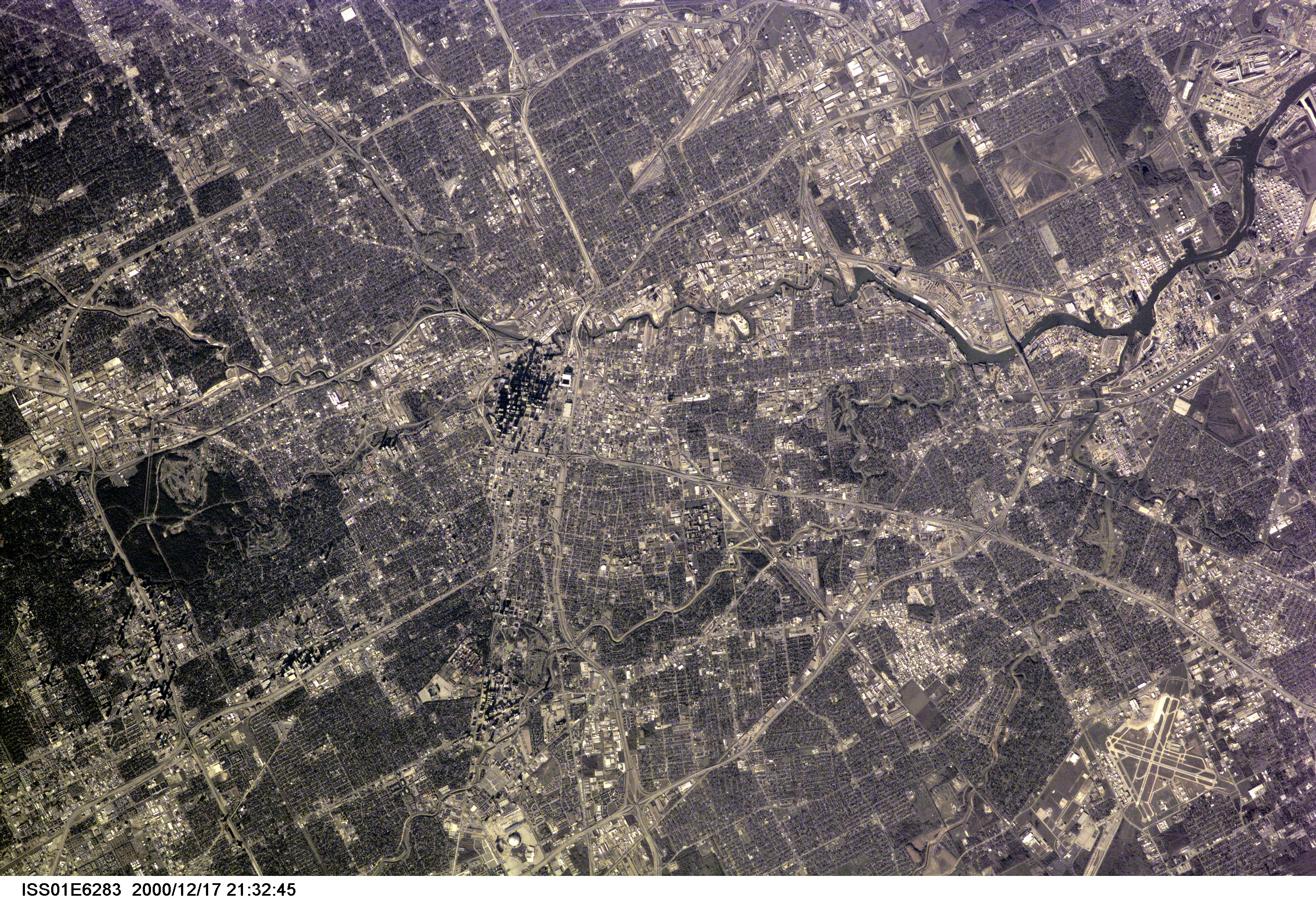
Downtown Houston from Space Station AlphaA series of digital photographs of Houston illustrates the new detail being obtained for cities around the world by crewmembers on the International Space Station. This image, captured on 17 December 2000 centers on the downtown region and shows extensive detail of streets, parks and major buildings. The retractable roof of the new Astros baseball stadium, Enron Field, is open. The spatial resolution of the image is about 6.7 m/pixel.
Photography of cities to monitor urban growth is one of the objectives of NASA’s Crew Earth Observations payload from the International Space Station. Other astronaut photographs of cities around the world can be viewed at the Cities from Space link from the NASA-JSC Gateway to Astronaut Photography of Earth
Download Packaged File.
This option downloads the following items, packaged into a single file, if they are available:
- Browse image
- Cataloged information with captions
- Camera file
- Sound file
Server: 2 |
This service is provided by the International Space Station program. |
Recommended Citation: |
||

