| Home >> | Advanced Search >> |
 |
|
Astronaut Photography of Earth - Display Record
STS111-E-5451

Low-resolution Browse Image
(Most browse images are not color adjusted.)Images
Conditions for Use of Images >>Image Transformation Tutorial >> Saving, Color Adjusting, and Printing Images >>
Images to View on Your Computer Now
| File Name | File Size (bytes) | Width | Height | Annotated | Cropped | Purpose | Comments | |
|---|---|---|---|---|---|---|---|---|
| View | STS111-E-5451.JPG | 34298 | 540 | 405 | Yes | Yes | NASA's Earth Observatory web site | |
| View | STS111-E-5451.JPG | 39785 | 639 | 435 | No | No | ||
| View | STS111-E-5451.JPG | 178981 | 540 | 405 | Photographic Highlights | (540px resized images) | ||
| View | STS111-E-5451.JPG | 513874 | 1000 | 691 | No | Yes | NASA's Earth Observatory web site |
Large Images to Request for Downloading
| File Name | File Size (bytes) | Width | Height | Annotated | Cropped | Purpose | Comments | |
|---|---|---|---|---|---|---|---|---|
| Request | STS111-E-5451.JPG | 404194 | 3032 | 2064 | No | No | ||
| Request | STS111-E-5451.JPG | 521159 | 1024 | 768 | Photographic Highlights | (actual files used) | ||
| Request | STS111-E-5451_2.JPG | 967126 | 3000 | 1987 | No | No | Updated image for database |
Download a Keyhole Markup Language (KML) file for use in Google Earth.
Electronic Image Data
Camera Files >> No sound file available.Identification
Mission: STS111 Roll: E Frame: 5451 Mission ID on the Film or image: STS111Country or Geographic Name: NORTH AMERICA
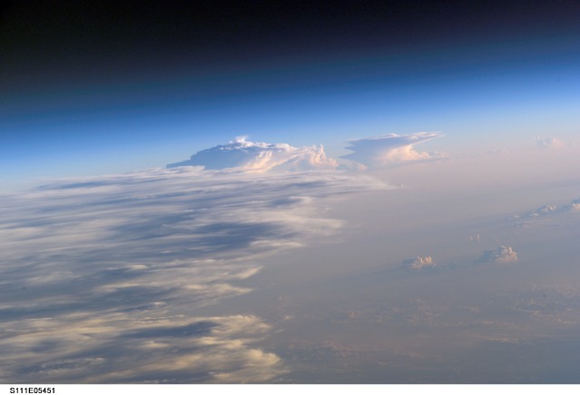
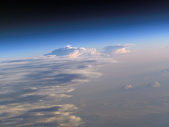
Features: PAN-THUNDERSTORMS, ANVILS
Center Point Latitude: Center Point Longitude: (Negative numbers indicate south for latitude and west for longitude)
Stereo: (Yes indicates there is an adjacent picture of the same area)
ONC Map ID: JNC Map ID:
Camera
Camera Tilt: High ObliqueCamera Focal Length: 400mm
Camera: E4: Kodak DCS760C Electronic Still Camera
Film: 3060E : 3060 x 2036 pixel CCD, RGBG array.
Quality
Film Exposure:Percentage of Cloud Cover: 100 (76-100)
Nadir
Date: 20020617 (YYYYMMDD)GMT Time: (HHMMSS)Nadir Point Latitude: , Longitude: (Negative numbers indicate south for latitude and west for longitude)
Nadir to Photo Center Direction:
Sun Azimuth: (Clockwise angle in degrees from north to the sun measured at the nadir point)
Spacecraft Altitude: nautical miles (0 km)
Sun Elevation Angle: (Angle in degrees between the horizon and the sun, measured at the nadir point)
Orbit Number:
Captions
Sharp air mass boundaries, such as this one photographed by astronauts on board the Space Shuttle on June 17 2002, often are the focus of development for severe thunderstorms. This storm formed in the late afternoon over Eastern China. The sunlit anvil tops of thunderstorms here are estimated to be in excess of 60,000 feet (18,300 m) where icy cirrus clouds form near the top of the troposphere. The distribution and impact of such high clouds are a significant challenge to scientists modeling the Earth’s energy budget and climate.The crew of the International Space Station is attempting to acquire such imagery over Florida this summer in support of a large, multi-agency experiment CRYSTAL - FACE (Cirrus Regional Study of Tropical Anvils and Cirrus Layers - Florida Area Cirrus Experiment). This experiment is designed to collect measurements of clouds that will help improve climate models. Such photos have the potential to provide profound, synoptic visuals for use in describing and interpreting these measurements. More information on CRYSTAL – FACE as well as other images of the atmosphere are available at http://cloud1.arc.nasa.gov/crystalface/
Download Packaged File.
This option downloads the following items, packaged into a single file, if they are available:
- Browse image
- Cataloged information with captions
- Camera file
- Sound file
Server: 2 |
This service is provided by the International Space Station program. |
Recommended Citation: |
||

