| Home >> | Advanced Search >> |
 |
|
Astronaut Photography of Earth - Display Record
ISS006-E-45591
Low-resolution Browse Image
(Most browse images are not color adjusted.)Images
Conditions for Use of Images >>Image Transformation Tutorial >> Saving, Color Adjusting, and Printing Images >>
Images to View on Your Computer Now
| File Name | File Size (bytes) | Width | Height | Annotated | Cropped | Purpose | Comments | |
|---|---|---|---|---|---|---|---|---|
| View | ISS006-E-45591.JPG | 69260 | 540 | 354 | Photographic Highlights | (540 px resized images) | ||
| View | ISS006-E-45591.JPG | 90532 | 540 | 405 | Yes | Yes | NASA's Earth Observatory web site | Color adjusted |
| View | ISS006-E-45591.JPG | 90532 | 540 | 405 | Yes | Yes | NASA's Earth Observatory web site | |
| View | ISS006-E-45591.JPG | 110558 | 639 | 435 | No | No | ||
| View | ISS006-E-45591.JPG | 953215 | 1000 | 650 | No | No | NASA's Earth Observatory web site |
Large Images to Request for Downloading
| File Name | File Size (bytes) | Width | Height | Annotated | Cropped | Purpose | Comments | |
|---|---|---|---|---|---|---|---|---|
| Request | ISS006-E-45591.JPG | 294082 | 1024 | 672 | Photographic Highlights | (actual files used) | ||
| Request | ISS006-E-45591.JPG | 1917459 | 3032 | 2064 | No | No |
Download a Keyhole Markup Language (KML) file for use in Google Earth.
Electronic Image Data
Camera Files >> No sound file available.Identification
Mission: ISS006 Roll: E Frame: 45591 Mission ID on the Film or image: ISS006Country or Geographic Name: RUSSIAN FEDERATION
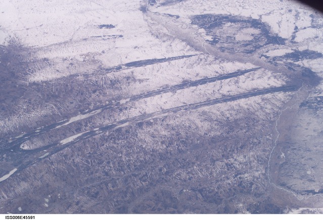
Features: KULUNDA STEPPE, OB RIVER, SNOW
Center Point Latitude: 53.0 Center Point Longitude: 82.5 (Negative numbers indicate south for latitude and west for longitude)
Stereo: (Yes indicates there is an adjacent picture of the same area)
ONC Map ID: JNC Map ID:
Camera
Camera Tilt: High ObliqueCamera Focal Length: 50mm
Camera: E4: Kodak DCS760C Electronic Still Camera
Film: 3060E : 3060 x 2036 pixel CCD, RGBG array.
Quality
Film Exposure:Percentage of Cloud Cover: 10 (0-10)
Nadir
Date: 20030410 (YYYYMMDD)GMT Time: 095632 (HHMMSS)Nadir Point Latitude: 50.7, Longitude: 87.2 (Negative numbers indicate south for latitude and west for longitude)
Nadir to Photo Center Direction: West
Sun Azimuth: 247 (Clockwise angle in degrees from north to the sun measured at the nadir point)
Spacecraft Altitude: 206 nautical miles (382 km)
Sun Elevation Angle: 27 (Angle in degrees between the horizon and the sun, measured at the nadir point)
Orbit Number: 1043
Captions
The dark spikes slashing across this agricultural area between the Ob River and the Irtysh River (out of the view left) form a familiar visual cue for astronauts that they are flying over Western Siberia. The signature pattern across the center is made by forests in a great plain that has been folded by tectonic forces—the surface rock layers form a long series of gentle folds aligned NE-SW. The lower zones are darker because the snow disappears through the Scotch pine trees. The higher areas are occupied by numerous angular fields of the steppe, etched by snow.The Ob is a major river of Siberia, draining from the Altai Mountains on the borders of western China and Mongolia in central Asia, thousands of miles to the Arctic Ocean. Great bends in a 300-km stretch of the Ob River appear on the right side of this north-looking view image (taken with a 50 mm lens, April 10, 2003).
The major Siberian city of Barnaul is the dark patch on a sharp bend in the Ob River (right margin). Barnaul is a major industrial and cultural center, but began as one of Russia’s most famous two mining cities, having supplied hundreds of tons of silver to the imperial coffers since the mid 1700s. Barnaul lies 200 km south of Novosibirsk, one of the most important cities on the Trans-Siberian railroad.
Download Packaged File.
This option downloads the following items, packaged into a single file, if they are available:
- Browse image
- Cataloged information with captions
- Camera file
- Sound file
Server: 2 |
This service is provided by the International Space Station program. |
Recommended Citation: |
||

