| Home >> | Advanced Search >> |
 |
|
Astronaut Photography of Earth - Display Record
ISS016-E-30127

Low-resolution Browse Image
(Most browse images are not color adjusted.)Images
Conditions for Use of Images >>Image Transformation Tutorial >> Saving, Color Adjusting, and Printing Images >>
Images to View on Your Computer Now
| File Name | File Size (bytes) | Width | Height | Annotated | Cropped | Purpose | Comments | |
|---|---|---|---|---|---|---|---|---|
| View | ISS016-E-30127.JPG | 65792 | 639 | 423 | No | No | ||
| View | ISS016-E-30127.JPG | 397477 | 540 | 397 | Yes | Yes | NASA's Earth Observatory web site |
Large Images to Request for Downloading
| File Name | File Size (bytes) | Width | Height | Annotated | Cropped | Purpose | Comments | |
|---|---|---|---|---|---|---|---|---|
| Request | ISS016-E-30127.JPG | 1064514 | 3032 | 2008 | No | No | ||
| Request | ISS016-E-30127.JPG | 1077533 | 1000 | 736 | No | Yes | NASA's Earth Observatory web site |
Download a Keyhole Markup Language (KML) file for use in Google Earth.
Electronic Image Data
Camera Files >> No sound file available.Identification
Mission: ISS016 Roll: E Frame: 30127 Mission ID on the Film or image: ISS016Country or Geographic Name: GERMANY
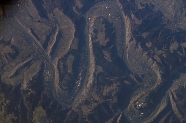
Features: MOSEL RIVER VALLEY, VINEYARDS
Center Point Latitude: 49.9 Center Point Longitude: 7.0 (Negative numbers indicate south for latitude and west for longitude)
Stereo: (Yes indicates there is an adjacent picture of the same area)
ONC Map ID: JNC Map ID:
Camera
Camera Tilt: High ObliqueCamera Focal Length: 800mm
Camera: E4: Kodak DCS760C Electronic Still Camera
Film: 3060E : 3060 x 2036 pixel CCD, RGBG array.
Quality
Film Exposure:Percentage of Cloud Cover: 10 (0-10)
Nadir
Date: 20080217 (YYYYMMDD)GMT Time: 144400 (HHMMSS)Nadir Point Latitude: 51.2, Longitude: 11.5 (Negative numbers indicate south for latitude and west for longitude)
Nadir to Photo Center Direction: West
Sun Azimuth: 230 (Clockwise angle in degrees from north to the sun measured at the nadir point)
Spacecraft Altitude: 176 nautical miles (326 km)
Sun Elevation Angle: 14 (Angle in degrees between the horizon and the sun, measured at the nadir point)
Orbit Number: 950
Captions
Moselle River Gorge, GermanyThe Moselle (Mosel in German) is the best known of the 13 German wine-growing regions. The beautiful scenery of this part of the Moselle makes it a popular tourist destination. The white Riesling grape produces some of the best wines in this cool region of northern Europe. Riesling vines represent almost 60% of the vineyards in the Middle Moselle Valley shown here.
This detailed image (width covers a distance of 14.5 kilometers, or about 9 miles) shows the winding Moselle River flowing north (left to right). The river has cut a gorge more than 300 meters (984 feet) deep into a relatively flat plateau. The plateau is covered mainly in dark green forests, with some large agricultural fields. Because this is one of the coolest places in Europe where grape vines grow, the warmer microclimates that occur in the valleys below the exposed and higher plateau are key to growing vines.
Within the narrow and very steep valley, those slopes which face south and west are best for grapes. The north-facing slopes not only receive less direct sunshine, but the deep shadows of the canyon walls fall on them sooner in the day. These shadows are visible on the canyon wall opposite Kroev and elsewhere, where they make the river difficult to see. The vine-covered slopes, with very small plot sizes, appear as light grays and light greens along most of the gorge slopes. In this view, slopes around the villages of Kroev, Kuess, and Maring enjoy the best south-facing aspect.
Available sunlight is so limited here that even the reflected light from the river surface is known to help the vines, an effect that also favors south-facing slopes. The landscape character has also affected wine prices. Less-favorable slopes have been planted with hardier grapes of lower quality. This in turn has sometimes reduced prices somewhat for all Moselle wines.
Many slopes are so steep that the grapes cannot be harvested mechanically, which makes these vines very labor intensive and potentially hazardous for workers. The village of Bremm just outside the picture at top right, has the steepest documented vineyard in the world, with vines growing on a 65-degree slope.
Download Packaged File.
This option downloads the following items, packaged into a single file, if they are available:
- Browse image
- Cataloged information with captions
- Camera file
- Sound file
Server: 2 |
This service is provided by the International Space Station program. |
Recommended Citation: |
||

