| Home >> | Advanced Search >> |
 |
|
Astronaut Photography of Earth - Display Record
STS092-324-26

Low-resolution Browse Image
(Most browse images are not color adjusted.)Images
Conditions for Use of Images >>Image Transformation Tutorial >> Saving, Color Adjusting, and Printing Images >>
Images to View on Your Computer Now
| File Name | File Size (bytes) | Width | Height | Annotated | Cropped | Purpose | Comments | |
|---|---|---|---|---|---|---|---|---|
| View | STS092-324-26.JPG | 32265 | 515 | 342 | No | No | From ISD highres, sharpened | |
| View | STS092-324-26.JPG | 49642 | 540 | 364 | Yes | Yes | NASA's Earth Observatory web site | |
| View | STS092-324-26.JPG | 161110 | 1551 | 1046 | No | Yes | NASA's Earth Observatory web site | |
| View | STS092-324-26_2.JPG | 26976 | 400 | 270 | No | Photographic Highlights |
Large Images to Request for Downloading
| File Name | File Size (bytes) | Width | Height | Annotated | Cropped | Purpose | Comments | |
|---|---|---|---|---|---|---|---|---|
| Request | STS092-324-26.JPG | 553046 | 3070 | 2044 | No | No | From ISD CD TIFF images | |
| Request | STS092-324-26.TIF | 4872084 | 1551 | 1046 | No | No |
Download a Keyhole Markup Language (KML) file for use in Google Earth.
Electronic Image Data
Camera files only apply to electronic still cameras.No sound file available.
Identification
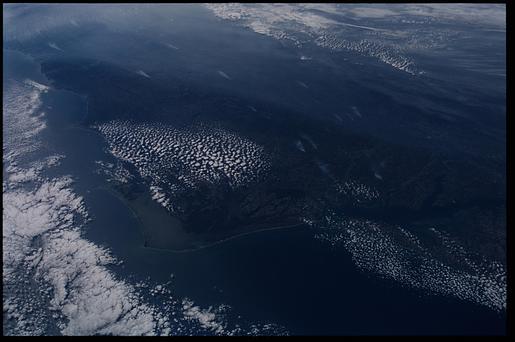
Mission: STS092 Roll: 324 Frame: 26 Mission ID on the Film or image: STS92Country or Geographic Name: USA-NORTH CAROLINA
Features: PAMLICO SOUND, SMOKE
Center Point Latitude: 36.5 Center Point Longitude: -76.5 (Negative numbers indicate south for latitude and west for longitude)
Stereo: (Yes indicates there is an adjacent picture of the same area)
ONC Map ID: JNC Map ID:
Camera
Camera Tilt: High ObliqueCamera Focal Length: mm
Camera: NK: Nikon 35mm film camera
Film: 5069 : Kodak Elite 100S, E6 Reversal, Replaces Lumiere, Warmer in tone vs. Lumiere.
Quality
Film Exposure:Percentage of Cloud Cover: 25 (11-25)
Nadir
Date: 20001023 (YYYYMMDD)GMT Time: 184241 (HHMMSS)Nadir Point Latitude: 37.2, Longitude: -71.0 (Negative numbers indicate south for latitude and west for longitude)
Nadir to Photo Center Direction: West
Sun Azimuth: 220 (Clockwise angle in degrees from north to the sun measured at the nadir point)
Spacecraft Altitude: 202 nautical miles (374 km)
Sun Elevation Angle: 32 (Angle in degrees between the horizon and the sun, measured at the nadir point)
Orbit Number: 186
Captions
This photograph taken from the Space Shuttle Discovery was taken at a slightly oblique look angle to better view air pollution and other atmospheric features. The photograph was taken with the Shuttle in a position over the Atlantic Ocean looking back toward the North Carolina and Virginia coast. The astronauts used a 35 mm camera and standard color film. The section of coast shown stretches from the Delmarva Peninsula on the right to beyond Charleston, South Carolina on the left.On October 23, 2000, high pressure centered over the northeastern U.S. had created a capping inversion for aerosols. Forest fire smoke and industrial air pollution accumulated under the inversion. The inversion pattern is stronger inland, and the aerosols are being banked against the Piedmont. Relatively clearer air is flowing from the ocean over the Carolina coastal plain. Small smoke plumes from individual fires can also be seen on the ground stretching from central Virginia to Raleigh, NC.
Download Packaged File.
This option downloads the following items, packaged into a single file, if they are available:
- Browse image
- Cataloged information with captions
- Camera file
- Sound file
Server: 2 |
This service is provided by the International Space Station program. |
Recommended Citation: |
||

