| Home >> | Advanced Search >> |
 |
|
Astronaut Photography of Earth - Display Record
ISS012-E-16633

Low-resolution Browse Image
(Most browse images are not color adjusted.)Images
Conditions for Use of Images >>Image Transformation Tutorial >> Saving, Color Adjusting, and Printing Images >>
Images to View on Your Computer Now
| File Name | File Size (bytes) | Width | Height | Annotated | Cropped | Purpose | Comments | |
|---|---|---|---|---|---|---|---|---|
| View | ISS012-E-16633.JPG | 77630 | 639 | 435 | No | No | ||
| View | ISS012-E-16633.JPG | 303997 | 540 | 380 | Yes | Yes | NASA's Earth Observatory web site |
Large Images to Request for Downloading
| File Name | File Size (bytes) | Width | Height | Annotated | Cropped | Purpose | Comments | |
|---|---|---|---|---|---|---|---|---|
| Request | ISS012-E-16633.JPG | 850751 | 1000 | 703 | No | Yes | NASA's Earth Observatory web site | |
| Request | ISS012-E-16633.JPG | 1072411 | 3032 | 2064 | No | No |
Download a Keyhole Markup Language (KML) file for use in Google Earth.
Electronic Image Data
Camera Files >> No sound file available.Identification
Mission: ISS012 Roll: E Frame: 16633 Mission ID on the Film or image: ISS012Country or Geographic Name: USA-SOUTH CAROLINA
Features: SAVANNAH RIVER PLANT,PAR POND
Center Point Latitude: 33.2 Center Point Longitude: -81.6 (Negative numbers indicate south for latitude and west for longitude)
Stereo: (Yes indicates there is an adjacent picture of the same area)
ONC Map ID: JNC Map ID:
Camera
Camera Tilt: 30Camera Focal Length: 400mm
Camera: E4: Kodak DCS760C Electronic Still Camera
Film: 3060E : 3060 x 2036 pixel CCD, RGBG array.
Quality
Film Exposure:Percentage of Cloud Cover: 10 (0-10)
Nadir
Date: 20060128 (YYYYMMDD)GMT Time: 185635 (HHMMSS)Nadir Point Latitude: 34.4, Longitude: -80.3 (Negative numbers indicate south for latitude and west for longitude)
Nadir to Photo Center Direction: Southwest
Sun Azimuth: 204 (Clockwise angle in degrees from north to the sun measured at the nadir point)
Spacecraft Altitude: 184 nautical miles (341 km)
Sun Elevation Angle: 34 (Angle in degrees between the horizon and the sun, measured at the nadir point)
Orbit Number: 1119
Captions
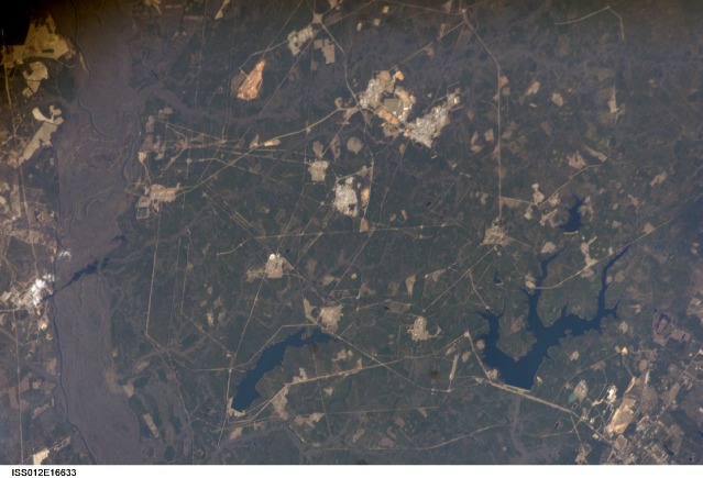
Savannah River Site, South CarolinaSituated between the South Carolina piedmont and the Atlantic Ocean, the Savannah River Site is an important part of the U.S. Department of Energy’s nuclear program. Construction of the site—originally called the Savannah River Plant—began in 1951 for the purpose of generating radioactive materials necessary for nuclear weapons production during the Cold War. A total of five nuclear reactors occupy the central portion of the site and operated throughout 1953–1992. Following the end of the Cold War in 1991, activities at the Savannah River Site are now focused on disposal of nuclear wastes, environmental cleanup of the site itself, and development of advanced remediation technologies.
The Savannah River Site is located in the Sand Hills region of South Carolina and includes an area of 800 square kilometers (about 300 square miles). The southern half of the site (building clusters with reflective white rooftops) is shown in this astronaut photograph. The nearby Savannah River and its tributary creeks provided a ready source of water for the nuclear reactors; to this end, two artificial lakes (“L” Lake and Par Pond) were constructed. The meandering channel of the river and its floodplain, characterized by grey-brown sediments, is visible on the far left of the image. Because the river is so close to the nuclear site and because the underlying geological materials (sand, clay, gravel, and carbonate rocks) are permeable, an extensive and ongoing environmental monitoring and cleanup effort is necessary to reduce potential contamination of local water sources. Final remediation of wastes posing threats to surface and groundwater is scheduled to occur by 2025.
Download Packaged File.
This option downloads the following items, packaged into a single file, if they are available:
- Browse image
- Cataloged information with captions
- Camera file
- Sound file
Server: 2 |
This service is provided by the International Space Station program. |
Recommended Citation: |
||

