| Home >> | Advanced Search >> |
 |
|
Astronaut Photography of Earth - Display Record
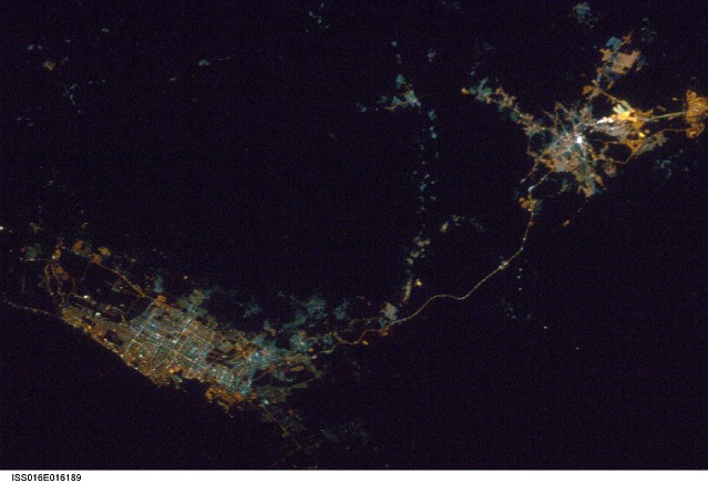
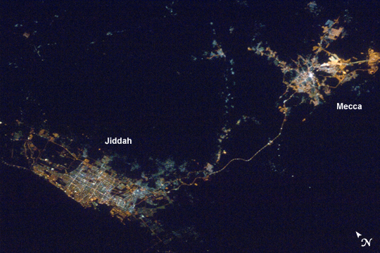
ISS016-E-16189
Low-resolution Browse Image
(Most browse images are not color adjusted.)Images
Conditions for Use of Images >>Image Transformation Tutorial >> Saving, Color Adjusting, and Printing Images >>
Images to View on Your Computer Now
| File Name | File Size (bytes) | Width | Height | Annotated | Cropped | Purpose | Comments | |
|---|---|---|---|---|---|---|---|---|
| View | ISS016-E-16189.JPG | 75333 | 639 | 436 | No | No | ||
| View | ISS016-E-16189.JPG | 263565 | 540 | 359 | Yes | Yes | NASA's Earth Observatory web site |
Large Images to Request for Downloading
| File Name | File Size (bytes) | Width | Height | Annotated | Cropped | Purpose | Comments | |
|---|---|---|---|---|---|---|---|---|
| Request | ISS016-E-16189.JPG | 897004 | 1000 | 664 | No | Yes | NASA's Earth Observatory web site | |
| Request | ISS016-E-16189.JPG | 2700362 | 3072 | 2096 | No | No |
Download a Keyhole Markup Language (KML) file for use in Google Earth.
Electronic Image Data
Camera Files >> No sound file available.Identification
Mission: ISS016 Roll: E Frame: 16189 Mission ID on the Film or image: ISS016Country or Geographic Name: SAUDI ARABIA
Features: JIDDAH,MECCA AT NIGHT
Center Point Latitude: 21.5 Center Point Longitude: 39.5 (Negative numbers indicate south for latitude and west for longitude)
Stereo: (Yes indicates there is an adjacent picture of the same area)
ONC Map ID: JNC Map ID:
Camera
Camera Tilt: 29Camera Focal Length: 85mm
Camera: N2: Nikon D2Xs
Film: 4288E : 4288 x 2848 pixel CMOS sensor, RGBG imager color filter.
Quality
Film Exposure:Percentage of Cloud Cover: 10 (0-10)
Nadir
Date: 20071211 (YYYYMMDD)GMT Time: 203147 (HHMMSS)Nadir Point Latitude: 22.9, Longitude: 40.4 (Negative numbers indicate south for latitude and west for longitude)
Nadir to Photo Center Direction: Southwest
Sun Azimuth: 266 (Clockwise angle in degrees from north to the sun measured at the nadir point)
Spacecraft Altitude: 181 nautical miles (335 km)
Sun Elevation Angle: -81 (Angle in degrees between the horizon and the sun, measured at the nadir point)
Orbit Number: 3880
Captions
The cities of Jiddah and Mecca, Saudi Arabia and the well-lit pilgrim road connecting them.Download Packaged File.
This option downloads the following items, packaged into a single file, if they are available:
- Browse image
- Cataloged information with captions
- Camera file
- Sound file
Server: 2 |
This service is provided by the International Space Station program. |
Recommended Citation: |
||

