|
|
  |
|
| Figure 1. Click to see
an animation of a tsunami generated by an earthquake. |
|
Tsunami is a set of ocean waves caused by any large, abrupt disturbance
of the sea-surface. If the disturbance is close to the coastline,
local tsunamis can demolish coastal communities within minutes.
A very large disturbance can cause local devastation AND export
tsunami destruction thousands of miles away. The word tsunami is
a Japanese word, represented by two characters: tsu, meaning, "harbor",
and nami meaning, "wave". Tsunamis rank high on the scale of natural
disasters. Since 1850 alone, tsunamis have been responsible for
the loss of over 420,000 lives and billions of dollars of damage
to coastal structures and habitats. Most of these casualties were
caused by local tsunamis that occur about once per year somewhere
in the world. For example, the December 26, 2004, tsunami killed
about 130,000 people close to the earthquake and about 58,000 people
on distant shores. Predicting when and where the next tsunami will
strike is currently impossible. Once the tsunami is generated, forecasting
tsunami arrival and impact is possible through modeling and measurement
technologies.
Generation. Tsunamis are most commonly
generated by earthquakes in marine and coastal regions. Major tsunamis
are produced by large (greater than 7 on the Richer scale), shallow
focus (< 30km depth in the earth) earthquakes associated with the
movement of oceanic and continental plates. They frequently occur
in the Pacific, where dense oceanic plates slide under the lighter
continental plates. When these plates fracture they provide a vertical
movement of the seafloor that allows a quick and efficient transfer
of energy from the solid earth to the ocean (try the animation in
Figure 1). When a powerful earthquake (magnitude 9.3) struck the
coastal region of Indonesia in 2004, the movement of the seafloor
produced a tsunami in excess of 30 meters (100 feet) along the adjacent
coastline killing more than 240,000 people. From this source the
tsunami radiated outward and within 2 hours had claimed 58,000 lives
in Thailand, Sri Lanka, and India.
Underwater landslides associated with smaller earthquakes are also
capable of generating destructive tsunamis. The tsunami that devastated
the northwestern coast of Papua New Guinea on July 17, 1998, was
generated by an earthquake that registered 7.0 on the Richter scale
that apparently triggered a large underwater landslide. Three waves
measuring more than 7 meter high struck a 10-kilometer stretch of
coastline within ten minutes of the earthquake/slump. Three coastal
villages were swept completely clean by the deadly attack leaving
nothing but sand and 2,200 people dead. Other large-scale disturbances
of the sea -surface that can generate tsunamis are explosive volcanoes
and asteroid impacts. The eruption of the volcano Krakatoa in the
East Indies on Aug. 27, 1883 produced a 30-meter tsunami that killed
over 36,000 people. In 1997, scientists discovered evidence of a
4km diameter asteroid that landed offshore of Chile approximately
2 million years ago that produced a huge tsunami that swept over
portions of South America and Antarctica.
|
 |
|
| Figure
2. Click to see the propagation of the December 24, 2004 Sumatra
tsunami. |
|
Wave Propagation.Because earth movements
associated with large earthquakes are thousand of square kilometers
in area, any vertical movement of the seafloor immediately changes
the sea-surface. The resulting tsunami propagates as a set of waves
whose energy is concentrated at wavelengths corresponding to the
earth movements (~100 km), at wave heights determined by vertical
displacement (~1m), and at wave directions determined by the adjacent
coastline geometry. Because each earthquake is unique, every tsunami
has unique wavelengths, wave heights, and directionality (Figure
2 shows the propagation of the December 24, 2004 Sumatra tsunami.)
From a tsunami warning perspective, this makes the problem of forecasting
tsunamis in real time daunting.
Warning Systems. Since 1946, the
tsunami warning system has provided warnings of potential tsunami
danger in the pacific basin by monitoring earthquake activity and
the passage of tsunami waves at tide gauges. However, neither seismometers
nor coastal tide gauges provide data that allow accurate prediction
of the impact of a tsunami at a particular coastal location. Monitoring
earthquakes gives a good estimate of the potential for tsunami generation,
based on earthquake size and location, but gives no direct information
about the tsunami itself. Tide gauges in harbors provide direct
measurements of the tsunami, but the tsunami is significantly altered
by local bathymetry and harbor shapes, which severely limits their
use in forecasting tsunami impact at other locations. Partly because
of these data limitations, 15 of 20 tsunami warnings issued since
1946 were considered false alarms because the tsunami that arrived
was too weak to cause damage.
|
 |
|
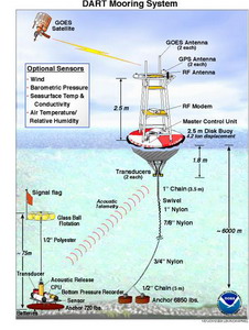
| Figure
3. Click to see a real-time deep ocean tsunami detection system
responding to a tsunami generated by seismic activity. |
|
Forecasting impacts. Recently developed
real-time, deep ocean tsunami detectors (Figure 3) will provide the
data necessary to make tsunami forecasts. The November 17, 2003,
Rat Is. tsunami in Alaska provided the most comprehensive test for
the forecast methodology. The Mw 7.8 earthquake on the shelf near
Rat Islands, Alaska, generated a tsunami that was detected by three
tsunameters located along the Aleutian Trench-the first tsunami
detection by the newly developed real-time tsunameter system. These
real-time data combined with the model database (Figure 4) were
then used to produce the real-time model tsunami forecast. For the
first time, tsunami model predictions were obtained during the tsunami
propagation, before the waves had reached many coastlines. The initial
offshore forecast was obtained immediately after preliminary earthquake
parameters (location and magnitude Ms = 7.5) became available from
the West Coast/Alaska TWC (about 15-20 minutes after the earthquake).
The model estimates provided expected tsunami time series at tsunameter
locations. When the closest tsunameter recorded the first tsunami
wave, about 80 minutes after the tsunami, the model predictions
were compared with the deep-ocean data and the updated forecast
was adjusted immediately..
These offshore model scenarios were then used as input for the
high-resolution inundation model for Hilo Bay. The model computed
tsunami dynamics on several nested grids, with the highest spatial
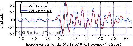
resolution of 30 meters inside the Hilo Bay (Figure 5). None of
the tsunamis produced inundation at Hilo, but all of them recorded
nearly half a meter (peak-to-trough) signal at Hilo gage. Model
forecast predictions for this tide gage are compared with observed
data in Figure 5. The comparison demonstrates that amplitudes, arrival
time and periods of several first waves of the tsunami wave train
were correctly forecasted. More tests are required to ensure that
the inundation forecast will work for every likely-to-occur tsunami.
When implemented, such forecast will be obtained even faster and
would provide enough lead time for potential evacuation or warning
cancellation for Hawaii and the U.S. West Coast.
 |
|
 |
|
|
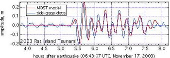
| Figure 4. Rat Island, Alaska Tsunami
of November 17, 2003, as measured at the tsunameter located
at 50 N 171 W in 4700 m water depth. |
Figure 5. Coastal forecast at Hilo,
HI for 2003 Rat island, showing comparison of the forecasted
(red line) and measured (blue line) gage data. |
|
|
Reduction of impact. The recent development
of real-time deep ocean tsunami detectors and tsunami inundation
models has given coastal communities the tools they need to reduce
the impact of future tsunamis. If these tools are used in conjunction
with a continuing educational program at the community level, at
least 25% of the tsunami related deaths might be averted. By contrasting
the casualties from the 1993 Sea of Japan tsunami with that of the
1998 Papua New Guinea tsunami, we can conclude that these tools work.
For the Aonae, Japan case about 15% of the population at risk died
from a tsunami that struck within 10 minutes of the earthquake because
the population was educated about tsunamis, evacuation plans had
been developed, and a warning was issued. For the Warapa, Papua
New Guinea case about 40% of the at risk population died from a
tsunami that arrived within 15 minutes of the earthquake because
the population was not educated, no evacuation plan was available,
and no warning system existed.
Eddie N. Bernard
Bernard, E.N. (1998): Program aims to reduce impact of tsunamis on Pacific states. Eos Trans. AGU, 79(22), 258, 262-263.
Bernard, E.N. (1999): Tsunami. Natural Disaster Management, Tudor Rose, Leicester, England, 58-60.
Synolakis, C., P. Liu, G. Carrier, H. Yeh, Tsunamigenic Sea-Floor Deformations, Science, 278, 598-600, 1997.
Dudley, Walter C., and Min Lee (1998): Tsunami! Second Edition, University of Hawai'i Press, Honolulu, Hawaii.
|
|