|
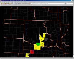
Recent Storm Reports Display
This display shows you the graphical representations of recent storm reports issued by NWS forecast offices.
Local storm reports issued during the past 90 minutes are displayed on the regional map. Report types displayed
on the map include tornado reports, severe wind reports (>= 58 mph), and severe hail reports (>= 0.75 inches)
Each report type is depicted by a specific color and symbol. Tornado reports are displayed as red "funnels"
(inverted triangles). Severe wind reports are represented by yellow squares with the wind values (in mph)
overlaid on the squares, while wind damage reports are shown as orange squares overlaid with the letters �WD�
(for wind damage).
Severe hail reports are symbolized by light blue hexagons with the letter "A" (old Surface Airways Observation [SAO]
code for hail) and hail size values (in inches) overlaid on the hexagons. It should be noted that the size of the hexagon
symbol increases based on the size of the hail listed in each storm report. In addition, the hail symbols darken as the
hail reports age with time.
Use the symbol/color key below to relate specific colors and shapes to specific storm report types.
 |
Tornado Reports |
 |
Severe Wind Speed Reports (>= 58 mph) |
 |
Wind Damage Reports |
 |
Severe Hail Reports (>= .75 inches) |
You can also view the most recent storm reports issued by each NWS office by selecting the specific County Warning Area (CWA)
for that office. The CWA boundaries are depicted by the brown lines on the regional map display. NWS office CWAs include: Norman
and Tulsa, OK; Amarillo,
Forth Worth, Lubbock,
Midland, and San Angelo, TX;
Dodge City and Wichita, KS;
Pueblo, CO; Little Rock, AR; and
Springfield, MO.
This web page is best viewed at a screen resolution of 800 x 600 pixels or higher.
|
|
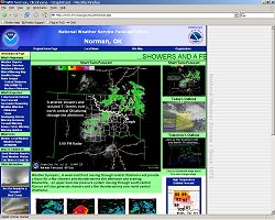
Enhanced Weather Web Page
The enhanced weather web page displays content that is driven by whatever hazardous weather is
expected or is occurring. The enhanced page features yellow
colors for a developing threat, and red for a significant hazardous
weather situation (which could be flooding, severe thunderstorms,
high fire danger, winter storm, etc).
included in this display are links to current conditions and forecast products as
well as hazard mitigation information and instructions on how to contact our office.
These links are tailored for each specific hazardous weather situation, and change
as the weather situation changes in the NWS Norman warning and forecast area.
The Enhanced Weather web page includes an automatic refresh rate of 60 seconds, and
the same scrolling headline, caption, and graphical display seen in the Weather Monitor web pages.
This web page is best viewed at a screen resolution of 1024 x 768 pixels or higher.
|