NCPTT’s Archeology & Collections program seeks to enhance the
preservation of archeological sites, landscapes, materials, and collections
through research, grants, and partnerships.
The April to September 2006 period was an active one for the
program along several fronts. In terms of training, the first archeological
component of the Summer Institute program debuted successfully in June. More
details follow below. Through the A&C program NCPTT also provided the NPS
Midwest Archeology Center $10,000 in support of an annual training course in
non-destructive archeological prospection techniques.
Several research initiatives continued to develop. For instance,
partners have been secured for the effort to develop a new chronological
technique based on the formation of an earthwork’s sediments. Washington
University conducted fieldwork at the Poverty Point World Heritage Site over the
summer, NCPTT began building an analytical GIS database and collected GPS data,
and samples currently are being prepared for sediment analysis at the University
of Minnesota. As another example, A&C staff members are working with the
Materials Research Program to assess the national need for a chemical technique
to strengthen bone artifacts subject to frequent handling.
Public outreach efforts and grants administration efforts remain
strong. Particularly visible were the second annual meeting of the
Archaeological Preservation Technology Research Consortium, co-hosted by NCPTT;
participation in the Society for American Archaeology and the U.S. ICOMOS
meetings; consultation work for a local preservation society and the Cane River
National Heritage Area; and acceptance of a manuscript for publication by American Anthropologist.
 Summer Institute Report: “Prospection in Depth”
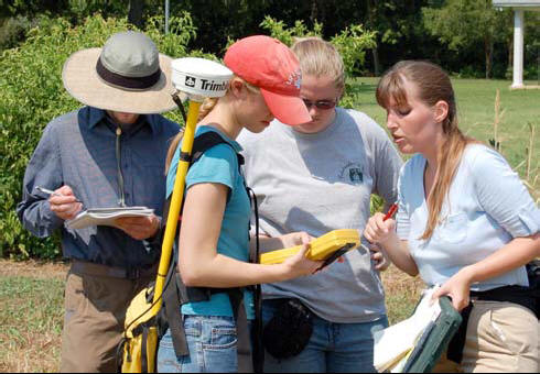
From June 6-23 NCPTT partnered with the NPS Midwest Archeology
Center, the NPS Cultural Resources GIS laboratory, the University of
Mississippi, and Northwestern State University of Louisiana to hold its first
training program on non-destructive archeological prospection techniques. This
intensive workshop is unique in that it provided hands-on training in the
integration of GIS, GPS, and remote sensing technology using data from an
ongoing, grant-funded research project. By collaborating with academic
researchers, moreover, the training event offered an unparalleled opportunity to
combine data collection with field testing. Four instructors and 10 participants
from all over the country used the St. Anne and Whittington plantation sites as
learning laboratories.
 Integrating the Web into Training
“Prospection in Depth” forms the basis for NCPTT’s first
online,
interactive training module. The website chronicles the interwoven
prospection and testing results of the Summer Institute participants and
instructors, plus the excavation efforts of the research teams funded by the
National Endowment for the Humanities and the U.K. Arts and Humanities Research
Council. The webpages were designed by NCPTT’s Sean Clifford, and content and
interpretation were provided by Archeology & Collection program staff.
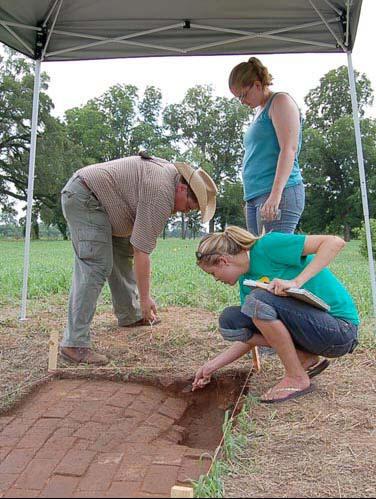
The 2006 fieldwork marks the third and most intensive season of
excavations undertaken as part of the academic research project. Consequently,
Summer Institute ground-truthing occurs within a well-documented historical,
archival, and archaeological set of contexts, making the training experience all
the more robust. The Summer Institute participants and instructors together
tested some 11 square meters covering key
geophysical anomalies. Then the international team of 11 researchers went on to
excavate an additional 89 square meters as units and some 6 square meters as 75
shovel tests.
The preliminary results are presented in these electronic pages
so that Summer Institute participants and others can learn from this unique
fusion of technological training and traditional research. The archeological
public is encouraged to join the teams in this endeavor by ground-truthing the
remote sensing data themselves. Visitors to the website are invited to:
-
select a site to explore
-
examine the remote sensing data
-
compare anomalies with excavation unit and/or shovel test
locations
-
virtually excavate the unit or shovel test in question by
studying the context (excavation)
forms, plan view drawings, profile drawings, and photographs
NCPTT plans to advertise the presence of the website throughout
the NPS and to the general public through its NCPTT Notes publication and through its electronic mailing list.
New Research Priority in the PTTGrants
NCPTT is pleased to announce that the
2006 call for grant
proposals has gone out with a new research priority:
NCPTT will give preference to research and training proposals
that develop innovative techniques in dating, monitoring, analysis, and remote
sensing of archeological sites and artifacts.