BY MORRIS L. MASLIA, JASON B. SAUTNER, MUSTAFA M. ARAL,
RICHARD E. GILLIG, JUAN J. REYES, AND ROBERT C. WILLIAMS
Prepared in coordination with:
New Jersey Department of Health and Senior Services
New Jersey Department of Environmental Protection
Ocean County Health Department
Citizens Action Committee on Childhood Cancer Cluster and
United Water Toms River, Inc.
Agency for Toxic Substances and Disease Registry
U.S. Department of Health and Human Services
Atlanta, Georgia
October 2001
MORRIS L. MASLIA, MSCE, PE
Research Environmental Engineer and Project Officer
Exposure-Dose Reconstruction Project
Division of Health Assessment and Consultation
Agency for Toxic Substances and Disease RegistryJASON B. SAUTNER, MSCE, EIT
Environmental Health Scientist
Division of Health Assessment and Consultation
Agency for Toxic Substances and Disease RegistryMUSTAFA M. ARAL, Ph.D., PE, PHy
Director, Multimedia Environmental Simulations Laboratory
School of Civil and Environmental Engineering
Georgia Institute of TechnologyRICHARD E. GILLIG, MCP
Supervisory Environmental Health Scientist
Chief, Superfund Site Assessment Branch
Division of Health Assessment and Consultation
Agency for Toxic Substances and Disease RegistryJUAN J. REYES, MSPA
Program Manager
Director, Office of Regional Operations
Office of the Assistant Administrator
Agency for Toxic Substances and Disease RegistryROBERT C. WILLIAMS, PE, DEE
Assistant Surgeon General
Director, Division of Health Assessment and Consultation
Agency for Toxic Substances and Disease Registry
For additional information, write to:
Project Officer
Exposure-Dose Reconstruction Project
Division of Health Assessment and Consultation
Agency for Toxic Substances and Disease Registry
1600 Clifton Road, Mail Stop E-32
Atlanta, Georgia 30333
The New Jersey Department of Health and Senior Services (NJDHSS), with support from the Agency for Toxic Substances and Disease Registry (ATSDR), is conducting an epidemiologic study of childhood cancers in Dover Township, Ocean County, New Jersey. In 1996, ATSDR and NJDHSS developed a Public Health Response Plan in cooperation with the Ocean County Health Department and the Citizens’ Action Committee on Childhood Cancer Cluster. The plan outlines a series of public health activities including assessments of potential environmental exposures in the community. In 1997, ATSDR and NJDHSS determined that an epidemiologic study was warranted, and that the study would include assessments of the potential for exposure to specific drinking-water sources.
To assist the epidemiologic efforts, ATSDR developed work plan to reconstruct historical characteristics of the water-distribution system serving the Dover Township area by using water-distribution system modeling techniques. The numerical model chosen for this effort, EPANET 2, is available in the public domain and is described in the scientific literature. To test the reliability of model simulations, water-distribution system data specific to the Dover Township area were needed to compare with model results. Lacking such data, a field-data collection effort was initiated to obtain pressure measurements, storage-tank water levels, and system operation schedules (the on-and-off cycling of wells and pumps) during winter-demand (March 1998) and peakdemand (August 1998) operating conditions. Using these data, the water-distribution system model was calibrated to present-day (1998) conditions. ATSDR released a report and a technical paper in June 2000 describing the field-data collection activities and model calibration results.
Having established the reliability of the model and the modeling approach, the model was used to examine (or reconstruct) plausible historical characteristics of the water-distribution system. For this purpose, monthly simulations were conducted from January 1962 through December 1996 to estimate the proportionate contribution of water from points of entry (well or well fields) to various locations throughout the Dover Township area.
This report provides a comprehensive description of the information used to conduct the analysis for the historical period and presents the following topics: (1) data sources and requirements, (2) methods of analysis, (3) simulation approaches, (4) selected simulation results of the historical reconstruction analysis, and (5) the use of sensitivity analysis to address issues of uncertainty and variability of historical system operations. An electronic version of this report is available over the Internet at the ATSDR web site at URL: www.atsdr.cdc.gov. Readers interested in a summary of this report should refer to the "Summary of Findings" that is also available at the ATSDR web site.
Authors
Foreword
Contents
List of Illustrations
List of Tables
Glossary and Abbreviations
Disclaimer
Abstract
Introduction
Background
Previous Investigation
Description of the Present-Day (1998) Water-Distribution System
External Expert Review
Specific Data Needs
Distribution-System Network Configurations
Production Data
Estimation and Distribution of Historical Consumption
Estimation of Historic Consumption
Distribution of Historic Consumption
High-Service and Booster Pump-Characteristic Curves
System Operations
Groundwater Wells
High-Service and Booster Pumps
Storage Tank and Water-Level Data
Data Availability, Quality, Methods, and Sources
Methods of Analysis and Approaches to Simulation
Overview
Hydraulic Modeling
Representation of Wells, Storage Tanks, and High-Service and Booster Pumps
Manual Adjustment Process
Genetic Algorithm (GA) Optimization
Water-Quality Modeling (Source-Trace Analysis)
Historical Reconstruction Analysis
Proportionate Contribution Results
Summary of Analyses
Review of Simulation Results for Selected Years and Months
1962—February, May, and October
1965—February, June, and October
1971—February, July, and October
1978—February, June, and October
1988—February, July, and October
1995—February, August, and October
1996—February, June, and October
Sensitivity Analysis
Overview
Variation of Operational and Hydraulic Constraints
Well- and Supply-Node-Pattern Factors
Minimum Pressure Criteria
Storage tank and Water-Level Difference Criteria
Daily System Operations
Results of Sensitivity Analyses
Genetic Algorithm (GA) Optimization Simulations
Daily System Operations Simulations
Summary and Findings
Availability of Model Input Data and Proportionate Contribution Results Files
Acknowledgments
References
Supplemental Data
[Supplemental Data are under separate cover]
Appendix A: Tables of water-distribution system pipeline characteristics, Dover Township area, New Jersey, 1962–96
Appendix B: Tables of water-distribution system groundwater-well production and operating data, Dover Township area, New Jersey,1962–96
Appendix C: Tables of water-distribution system operations used in EPANET 2, Dover Township area, New Jersey, 1962, 1965, 1971, 1978, 1988, 1995, and 1996
Appendix D: Tables of groundwater-well and high-service and booster pump operations, Dover Township area, New Jersey, minimum-, maximum-, and average-demand months, 1962, 1965, 1971, 1978, 1988, 1995, and 1996
Appendix E: Reconstruction of hydraulic management of a water-distribution system using genetic algorithms, by M.M. Aral, J. Guan, M.L. Maslia, and J.B. Sautner
Appendix F: Tables of wells and well fields (points of entry) and EPANET 2 source-node identifications used to conduct monthly source-trace analyses, Dover Township area, New Jersey, 1962–96
Appendix G: Tables of simulated proportionate contribution of water derived using the manual adjustment process, Dover Township area, New Jersey, 1962, 1965, 1971, 1978, 1988, 1995, and 1996
Appendix H: Graphs of simulated proportionate contribution of water derived using the manual adjustment process, Dover Township area, New Jersey, minimum-, maximum-, and average-demand months, 1962, 1965, 1971, 1978, 1988, 1995, and 1996
Appendix I: Tables of simulated proportionate contribution of water derived using genetic algorithm (GA) methods, sensitivity analyses SENS0, Dover Township area, New Jersey, 1962, 1965, 1971, 1978, 1988, 1995, and 1996
Appendix J: Graphs of simulated proportionate contribution of water derived using genetic algorithm (GA) methods, sensitivity analyses SENS0, Dover Township area, New Jersey, minimum-, maximum, and average-demand months, 1962, 1965, 1971, 1978, 1988, 1995, and 1996
Appendix K: Tables of absolute difference in simulated proportionate contribution of water between the manual adjustment process and genetic algorithm (GA) methods for sensitivity analyses SENS0, Dover Township area, New Jersey, 1962, 1965, 1971, 1978, 1988, 1995, and 1996
LIST OF ILLUSTRATIONS
[Plates are under separate cover]
Plates 1–2. Maps showing:
1. Location of area of investigation, Dover Township area, Ocean County, New Jersey - PDF
2. Present-day (1998) water-distribution system serving the Dover Township area,New Jersey - PDF
Plates 3–37. Maps showing water-distribution system serving the Dover Township area, New Jersey - PDF
3. 1962 - PDF
4. 1963 - PDF
5. 1964 - PDF
6. 1965 - PDF
7. 1966 - PDF
8. 1967 - PDF
9. 1968 - PDF
10. 1969 - PDF
11. 1970 - PDF
12. 1971 - PDF
13. 1972 - PDF
14. 1973 - PDF
15. 1974 - PDF
16. 1975 - PDF
17. 1976 - PDF
18. 1977 - PDF
19. 1978 - PDF
20. 1979 - PDF
21. 1980 - PDF
22. 1981 - PDF
23. 1982 - PDF
24. 1983 - PDF
25. 1984 - PDF
26. 1985 - PDF
27. 1986 - PDF
28. 1987 - PDF
29. 1988 - PDF
30. 1989 - PDF
31. 1990 - PDF
32. 1991 - PDF
33. 1992 - PDF
34. 1993 - PDF
35. 1994 - PDF
36. 1995 - PDF
37. 1996 - PDF
Plates 38–45. Aerial photographs:
38. CNC-2DD-44 showing residences and buildings serviced by the water-distribution system, central Dover Township area, New Jersey, June 1963 - PDF
39. CNC-1DD-266 showing residences and buildings serviced by the water-distribution system, west-central Dover Township area, New Jersey, June 1963 - PDF
40. 1486-9-424 showing residences and buildings serviced by the water-distribution system, central Dover Township area, New Jersey, April 1965 - PDF
41. 1486-10-144 showing residences and buildings serviced by the water-distribution system, northeastern Dover Township area, New Jersey, April 1965 - PDF
42. CGG-253 showing residences and buildings serviced by the water-distribution system, southwest Dover Township area, New Jersey, April 1968 - PDF
43. DSG-63 showing residences and buildings serviced by the water-distribution system, northern Dover Township area, New Jersey, April 1972 - PDF
44. 2111-18-659 showing residences and buildings serviced by the water-distribution system, northwestern Dover Township area, New Jersey, March 1976 - PDF
45. 2111-19-626 showing residences and buildings serviced by the water-distribution system, western Dover Township area, New Jersey, March 1976 - PDF
Plates 46–51. Maps showing areal distribution of land-use classification assigned to pipeline nodes:
46. 1998 water-distribution system, Dover Township area, New Jersey - PDF
47. 1996 water-distribution system, Dover Township area, New Jersey - PDF
48. 1990 water-distribution system, Dover Township area, New Jersey - PDF
49. 1978 water-distribution system, Dover Township area, New Jersey - PDF
50. 1967 water-distribution system, Dover Township area, New Jersey - PDF
51. 1962 water-distribution system, Dover Township area, New Jersey - PDF
Plates 52–153. Maps showing areal disstribution of simulated proportionate contribution of water from the:
52. Holly wells (13, 14) to locations in the Dover Township area, New Jersey, February 1962 conditions - PDF
53. Brookside well (15) to locations in the Dover Township area, New Jersey, February 1962 conditions - PDF
54. Holly wells (13, 14) to locations in the Dover Township area, New Jersey, May 1962 conditions - PDF
55. Brookside well (15) to locations in the Dover Township area, New Jersey, May 1962 conditions - PDF
56. Holly wells (13, 14) to locations in the Dover Township area, New Jersey, October 1962 conditions - PDF
57. Brookside well (15) to locations in the Dover Township area, New Jersey, October 1962 conditions - PDF
58. Holly well (16) to locations in the Dover Township area, New Jersey, February 1965 conditions - PDF
59. Brookside well (15) to locations in the Dover Township area, New Jersey, February 1965 conditions - PDF
60. Holly wells (14, 16, 18) to locations in the Dover Township area, New Jersey, June 1965 conditions - PDF
61. Brookside well (15) to locations in the Dover Township area, New Jersey, June 1965 conditions - PDF
62. Holly wells (14, 16, 18) to locations in the Dover Township area, New Jersey, October 1965 conditions< - PDF/p>
63. Brookside well (15) to locations in the Dover Township area, New Jersey, October 1965 conditions - PDF
64. Holly wells (16, 18, 19) to locations in the Dover Township area, New Jersey, February 1971 conditions - PDF
65. Brookside well (15) to locations in the Dover Township area, New Jersey, February 1971 conditions - PDF
66. South Toms River well (17) to locations in the Dover Township area, New Jersey, February 1971 conditions - PDF
67. Indian Head well (20) to locations in the Dover Township area, New Jersey, February 1971 conditions - PDF
68. Anchorage well to locations in the Dover Township area, New Jersey, February 1971 conditions - PDF
69. Silver Bay well to locations in the Dover Township area, New Jersey, February 1971 conditions - PDF
70. Holly wells (14, 16, 18, 19, 21) to locations in the Dover Township area, New Jersey, July 1971 conditions - PDF
71. Brookside well (15) to locations in the Dover Township area, New Jersey, July 1971 conditions - PDF
72. South Toms River well (17) to locations in the Dover Township area, New Jersey, July 1971 conditions - PDF
73. Indian Head well (20) to locations in the Dover Township area, New Jersey, July 1971 conditions - PDF
74. Parkway wells (22, 23, 26, 27) to locations in the Dover Township area, New Jersey, July 1971 conditions - PDF
75. Anchorage well to locations in the Dover Township area, New Jersey, July 1971 conditions - PDF
76. Silver Bay well to locations in the Dover Township area, New Jersey, July 1971 conditions - PDF
77. Holly wells (16, 18, 19) to locations in the Dover Township area, New Jersey, October 1971 conditions - PDF
78. Brookside well (15) to locations in the Dover Township area, New Jersey, October 1971 conditions - PDF
79. South Toms River well (17) to locations in the Dover Township area, New Jersey, October 1971 conditions - PDF
80. Indian Head well (20) to locations in the Dover Township area, New Jersey, October 1971 conditions - PDF
81. Anchorage well to locations in the Dover Township area, New Jersey, October 1971 conditions - PDF
82. Silver Bay well to locations in the Dover Township area, New Jersey, October 1971 conditions - PDF
83. Holly wells (16, 18) to locations in the Dover Township area, New Jersey, February 1978 conditions - PDF
84. South Toms River well (17) to locations in the Dover Township area, New Jersey, February 1978 conditions - PDF
85. Indian Head well (20) to locations in the Dover Township area, New Jersey, February 1978 conditions - PDF
86. Parkway wells (22, 24, 26, 28, 29) to locations in the Dover Township area, New Jersey,February 1978 conditions - PDF
87. Holly wells (16, 18, 19, 21) to locations in the Dover Township area, New Jersey, June 1978conditions - PDF
88. Brookside well (15) to locations in the Dover Township area, New Jersey, June 1978 conditions - PDF
89. South Toms River well (17) to locations in the Dover Township area, New Jersey, June 1978 conditions - PDF
90. Indian Head well (20) to locations in the Dover Township area, New Jersey, June 1978 conditions - PDF
91. Parkway wells (22, 23, 24, 25, 26, 27, 28, 29) to locations in the Dover Township area, New Jersey, June 1978 conditions - PDF
92. Anchorage well to locations in the Dover Township area, New Jersey, June 1978 conditions - PDF
93. Silver Bay well to locations in the Dover Township area, New Jersey, June 1978 conditions - PDF
94. Holly wells (16, 18, 19) to locations in the Dover Township area, New Jersey, October 1978 conditions - PDF
95. Brookside well (15) to locations in the Dover Township area, New Jersey, October 1978 conditions - PDF
96. South Toms River well (17) to locations in the Dover Township area, New Jersey, October 1978 conditions - PDF
97. Indian Head well (20) to locations in the Dover Township area, New Jersey, October 1978 conditions - PDF
98. Parkway wells (24, 26, 28, 29) to locations in the Dover Township area, New Jersey, October 1978 conditions - PDF
99. Holly well (30) to locations in the Dover Township area, New Jersey, February 1988 conditions - PDF
100. Brookside well (15) to locations in the Dover Township area, New Jersey, February 1988 conditions - PDF
101. South Toms River well (32) to locations in the Dover Township area, New Jersey, February 1988 conditions - PDF
102 Parkway wells (22, 24) to locations in the Dover Township area, New Jersey, February 1988 conditions - PDF
103. Route 70 well (31) to locations in the Dover Township area, New Jersey, February 1988 conditions - PDF
104. Berkeley wells (33, 34) to locations in the Dover Township area, New Jersey, February 1988 conditions - PDF
105. Holly wells (21, 30) to locations in the Dover Township area, New Jersey, July 1988 conditions - PDF
106. Brookside well (15) to locations in the Dover Township area, New Jersey, July 1988 conditions - PDF
107. South Toms River wells (32, 38) to locations in the Dover Township area, New Jersey, July 1988 conditions - PDF
108. Indian Head well (20) to locations in the Dover Township area, New Jersey, July 1988 conditions - PDF
109. Parkway wells (22, 23, 24, 26, 28, 29) to locations in the Dover Township area, New Jersey, July 1988 conditions - PDF
110. Route 70 well (31)to locations in the Dover Township area, New Jersey, July 1988 conditions - PDF
111. Berkeley wells (33, 34, 35) to locations in the Dover Township area, New Jersey, July 1988 conditions - PDF
112. Holly well (30) to locations in the Dover Township area, New Jersey, October 1988 conditions - PDF
113. South Toms River well (32) to locations in the Dover Township area, New Jersey, October 1988 conditions - PDF
114. Indian Head well (20) to locations in the Dover Township area, New Jersey, October 1988 conditions - PDF
115. Parkway wells (22, 23, 24, 26, 28, 29) to locations in the Dover Township area, New Jersey, October 1988 conditions - PDF
116. Route 70 well (31) to locations in the Dover Township area, New Jersey, October 1988 conditions - PDF
117. Berkeley wells (33, 34, 35) to locations in the Dover Township area, New Jersey, October 1988 conditions - PDF
118. South Toms River well (32) to locations in the Dover Township area, New Jersey, February 1995 conditions - PDF
119. Indian Head well (20) to locations in the Dover Township area, New Jersey, February 1995 conditions - PDF
120. Parkway wells (22, 24, 28, 29, 42) to locations in the Dover Township area, New Jersey, February 1995 conditions - PDF
121. Route 70 well (31) to locations in the Dover Township area, New Jersey, February 1995 conditions - PDF
122. Berkeley wells (33, 34, 35) to locations in the Dover Township area, New Jersey, February 1995 conditions - PDF
123. Holly wells (21, 30, 37) to locations in the Dover Township area, New Jersey, August 1995 conditions - PDF
124. Brookside well (15) to locations in the Dover Township area, New Jersey, August 1995 conditions - PDF
125. South Toms River wells (32, 38) to locations in the Dover Township area, New Jersey, August 1995 conditions - PDF
126. Indian Head well (20) to locations in the Dover Township area, New Jersey, August 1995 conditions - PDF
127. Parkway wells (22, 24, 26, 28, 29, 39, 41, 42) to locations in the Dover Township area, New Jersey, August 1995 conditions - PDF
128. Route 70 well (31) to locations in the Dover Township area, New Jersey, August 1995 conditions - PDF
129. Berkeley wells (33, 34, 35) to locations in the Dover Township area, New Jersey, August 1995 conditions - PDF
130. Windsor well (40) to locations in the Dover Township area, New Jersey, August 1995 conditions - PDF
131. Holly well (30) to locations in the Dover Township area, New Jersey, October 1995 conditions - PDF
132. Indian Head well (20) to locations in the Dover Township area, New Jersey, October 1995 conditions - PDF
133. Parkway wells (22, 24, 26, 28, 29, 42) to locations in the Dover Township area, New Jersey, October 1995 conditions - PDF
134. Route 70 well (31) to locations in the Dover Township area, New Jersey, October 1995 conditions - PDF
135. Berkeley wells (33, 34, 35) to locations in the Dover Township area, New Jersey, October 1995 conditions - PDF
136. Windsor well (40) to locations in the Dover Township area, New Jersey, October 1995 conditions - PDF
137. South Toms River well (32) to locations in the Dover Township area, New Jersey, February 1996 conditions - PDF
138. Indian Head well (20) to locations in the Dover Township area, New Jersey, February 1996 conditions - PDF
139. Parkway wells (22, 24, 26, 28, 29, 42) to locations in the Dover Township area, New Jersey, February 1996 conditions - PDF
140. Route 70 well (31) to locations in the Dover Township area, New Jersey, February 1996 conditions - PDF
141. Berkeley wells (33, 34) to locations in the Dover Township area, New Jersey, February 1996 conditions - PDF
142. Holly well (30) to locations in the Dover Township area, New Jersey, June 1996 conditions - PDF
143. Brookside well (15) to locations in the Dover Township area, New Jersey, June 1996 conditions - PDF
144. South Toms River wells (32, 38) to locations in the Dover Township area, New Jersey, June 1996 conditions - PDF
145. Parkway wells (22, 24, 26,28, 29, 42) to locations in the Dover Township area, New Jersey, June 1996 conditions - PDF
146. Route 70 well (31) to locations in the Dover Township area, New Jersey, June 1996 conditions - PDF
147. Berkeley wells (33, 34, 35) to locations in the Dover Township area, New Jersey, June 1996 conditions - PDF
148. Windsor well (40) to locations in the Dover Township area, New Jersey, June 1996 conditions - PDF
149. Holly well (30) to locations in the Dover Township area, New Jersey, October 1996 conditions - PDF
150. South Toms River well (32) to locations in the Dover Township area, New Jersey, October 1996 conditions - PDF
151. Parkway wells (22, 24, 26, 28, 29, 42) to locations in the Dover Township area, New Jersey, October 1996 conditions - PDF
152. Route 70 well (31) to locations in the Dover Township area, New Jersey, October 1996 conditions - PDF
153. Berkeley wells (33, 34, 35) to locations in the Dover Township area, New Jersey, October 1996 conditions - PDF
Figure 1. Map showing investigation area, Dover Township, Ocean County, New Jersey
2. Diagram showing key steps in the historical reconstruction analysis
3. Map showing water-distribution system serving the Dover Township area, New Jersey, 1998
4. Graphs showing diurnal water use for 1998: (A) winter-time demand, and (B) summer-time demand
Figures 5–8. Maps showing water-distribution system serving the Dover Township area, New Jersey:
5. 1962
6. 1971
7. 1988
8. 1996
Figures 9–11. Graphs showing:
9. Percentage of network pipeline material type by year, Dover Township area, New Jersey, 1962–96
10. Total network pipeline length and total customers served, Dover Township area,New Jersey, 1962–96
11. Minimum, mean, and maximum annual production of water, Dover Township area, New Jersey, 1962–96
Figure 12. Plot showing three-dimensional representation of monthly production of water, Dover Township area, New Jersey, 1962–96
13. Graph showing groundwater-well capacity, Dover Township area, New Jersey, 1962–96
14. Charts showing annual production of water by well or well field, Dover Township area, New Jersey, 1962–96
Figures 15–17. Diagrams showing:
15. Hypothetical present-day network with spatial distribution of demand and production
16. Historical Network (A) with spatial distribution of demand and production
17. Historical Network (B) with spatial distribution of demand and production
Figure 18. Graph showing storage-tank capacity, Dover Township area, New Jersey, 1962–96
19. Diagram showing distribution system representation of groundwater well, storage tank, and high-service and booster pump combination for (A) physical, "real-world" network, and (B) model network used for historical reconstruction analysis
20. Graphs showing measured and simulated flows using the Well-Storage Tank-Pump (WSTP) and Supply-Node-Link (SNL) simulation methods, Dover Township area, New Jersey, August 1998 at (A) Holly treatment plant, and (B) Parkway treatment plant
Figure 21. Map showing areal distribution of simulated proportionate contribution of water from the Parkway wells (22, 23, 24, 26, 28, 29) to locations in the Dover Township area, New Jersey, July 1988 conditions (manual adjustment process)
22. Graph showing simulated proportionate contribution of water from wells and well fields to selected locations, Dover Township area, New Jersey, July 1988 (manual adjustment process)
Figures 23–25. Graphs showing annual variation of simulated proportionate contribution of water from wells and well fields to selected locations, Dover Township area, New Jersey
23. Minimum-demand months, 1962–96 (manual adjustment process)
24. Maximum-demand months, 1962–96 (manual adjustment process)
25. Average-demand months, 1962–96 (manual adjustment process)
26. Map showing areal distribution of simulated proportionate contribution of water from the Parkway wells (22, 23, 24, 26, 28, 29) to locations in the Dover township area, New Jersey, July 1988 conditions (sensitivity analyses SENS0)
Figures 27–33. Graphs showing:
27. Simulated proportionate contribution of water derived from the manual adjustment process and Genetic Algorithm (GA) optimization simulation SENS0 for selected pipeline locations, Dover Township area, New Jersey, February, July, and October 1988
28. Pattern factors derived using the manual adjustment process and sensitivity analyses SENS0, supply nodes represent Parkway well 23 and Parkway well 24, July 1988 conditions
29. Pattern factors derived using the manual adjustment process and sensitivity analysis SENS1, supply node represents Parkway well 26, minimum-, maximum-, and average-demand months, 1978, 1988, and 1996
30. Pattern factors derived using the manual adjustment process and the sensitivity analyses, supply node represents Parkway well 22, October 1996 conditions
31. Differences in proportionate contributions of water derived from sensititivy analyses maximum-, minimum-, and average-demand months, 1971, 1978, 1988, and, 1996
32. Histograms of differences in proportionate contribution of water derived using the manual simulation approach sensitivity analyses maximum-, minimum-, and average-demand months, 1971, 1978, 1988, and 1996
33. Results for simulated proportionate contribution of water from wells and well fields to selected pipeline locations using day- and month-long simulations, minimum-, maximum-, and average-demand months, 1996 (manual adjustment process)
LIST OF TABLES
Table 1. Water-distribution system configuration, Dover Township area, New Jersey, 1962–96
2. Type of water treatment used by the present-day (1998) water-distribution system, Dover Township area, New Jersey
3. Land-use classification analysis for present-day (1998) and historical pipeline networks, Dover Township, New Jersey
4. "Master Operating Criteria" used to develop operating schedules for the historical waterdistribution system, Dover Township area, New Jersey
Tables 5–8. Water-distribution system operating schedule, Dover Township area, New Jersey:
5. May 1962
6. July 1971
7. July 1988
8. June 1996
Table 9. High-service and booster pump data, Dover Township area, New Jersey, 1962–96 42
10. Storage-tank characterization data used for historical reconstruction analysis, Dover Township area, New Jersey, 1962–96
11. Summary of specific data types used to conduct the historical reconstruction analysis, Dover Township area, New Jersey
12. Data availability and methods of obtaining data for historical reconstruction analysis, Dover Township area, New Jersey
13. Summary of model parameters, data availability, and time-unit variation for historical reconstruction analysis, Dover Township area, New Jersey
14. Production and supply data for a hypothetical distribution system
15. Water supply for a hypothetical distribution system computed using the Supply-Node-Link (SNL) method
16. Comparison of measured high-service pump flows and the Well-Storage Tank-Pump and Supply-Node-Link simulation methods, Dover Township area, New Jersey, August 1998
17. Well or well field (point of entry) for which simulated proportionate contribution results are shown on maps, year and month of analysis, and map identification number
18. Correspondence between pipeline location letters and model node numbers for which simulated proportionate contribution results are discussed in text and shown in figures and on plates
19. Presentation of proportionate contribution results for wells and well fields for selected pipeline locations, year and month of analysis, and location in report, manual adjustment process
20. Description of operational and hydraulic constraints varied for sensitivity analyses
21. Identification of year and month for conducting sensitivity analysis simulations
22. Presentation of proportionate contribution results for wells and well fields for selected pipeline locations using sensitivity analyses SENS0, year, month of analysis, and location in report
23. Statistical summary of differences in simulated proportionate contribution of water between the manual adjustment process and sensitivity analyses
GLOSSARY AND ABBREVIATIONS
Definition of terms and abbrevations used throughout this report are listed below:
Term or Abbreviation |
Definition |
|---|---|
AC |
Asbestos cement water pipeline |
ATSDR |
Agency for Toxic Substances and Disease Registry |
CD-ROM |
Computer disc, read only memory |
CERCLA |
Comprehensive Environmental Response, Compensation, and Liability Act; is also known as Superfund |
Consumption |
The use of water by customers of a water utility; is also known as demand. In a water-distribution system, consumption should equal production if there are no losses through leaks or pipe breaks |
Direct measurement or observation |
A method of obtaining data that is based on measuring or observing the parameter of interest. |
EPA |
U.S. Environmental Protection Agency |
EPANET 2 |
A water-distribution system model developed by the EPA |
EPS model |
Extended period simulation model; a simulation method used to analyze a water-distribution system that is characterized by time-varying demand and operating conditions |
Epidemiologic study |
A study to determine whether a relation exists between the occurrence and frequency of a disease and a specific factor such as exposure to a toxic compound found in the environment |
ft |
Foot (feet) |
GA |
Genetic Algorithm; a method of optimization that attempts to find the most optimal solution by mimicking the mechanics of natural selection and genetics |
GIS |
Geographic information system |
gal |
gallon(s) |
gpm |
gallon(s) per minute |
Historical reconstruction |
A diagnostic analysis used to examine the historical characteristics of a water-distribution system |
in. |
Inch(s) |
Link |
The representation of a length of pipeline section in EPANET 2 |
Manual adjustment process |
A modeling approach whereby a balanced flow condition is achieved through the repeated modification and refinement of modeling parameters by the analyst |
Master Operating Criteria |
Guidelines developed for operating a water-distribution system that are based, in part, on hydraulic engineering principles |
Maximum-demand month |
A time during a prescribed year when water usage is greatest; is also known as a peak- or summer-demand period |
MGD |
Million gallons per day |
Mgal |
Million gallons |
mi |
Mile(s) |
Minimum-demand month |
A time during a prescribed year when water usage is least; is also known as a low- or winter-demand period |
Model node |
The representation of the end point of a section of pipeline in EPANET 2; is also known as pipeline junction |
NJDHSS |
New Jersey Department of Health and Senior Services |
NPL |
National Priorities List; the EPA’s official list of hazardous waste sites which are to be cleaned up under the Superfund |
Pipeline junction |
Representation of the end point of a section of pipeline in EPANET 2; is also known as model node |
Point demand |
The spatial distribution of total consumption to pipeline or model locations based on measured data such as metered billing records |
Point of entry |
The location where water enters a water-distribution system from a source such as an aquifer, lake, stream, or river. For the Dover Township area, the points of entry are the wells and well fields |
Production |
The processing of potable water by a water utility and the delivery of the water to locations serviced by the water-distribution system. In a water-distribution system, production should equal consumption if there are no losses through leaks, pipe breaks, or non-metered water usage. |
Proportionate contribution |
The derivation of water from one or more sources in differing proportions. The sum of the proportionate contribution at any location in the water-distribution system should equal 100% |
PVC, PE, IPS |
Types of plastic water pipelines |
psi |
pounds per square inch |
Qualitative description |
A method of estimating data that is based on inference or is synthesized using surrogate information |
Quantitative estimate |
A method of estimating data that based on using computational techniques |
SAN |
Styrene-acrylonitrile trimer |
Sensitivity analysis |
A method of characterizing or quantifying uncertainty and variability. This involves conducting a series of model simulations, changing specific parameter or constraint values, and comparing the effect of changed parameter(s) or constraint(s) with reference to a base condition |
Source-trace analysis |
A method used to identify the source of delivered water using a waterdistribution model. A source-trace analysis can be used to track the percentage of water reaching any point in a water-distribution system over time from a specified location or source |
SNL |
Supply-node-link simulation method |
Steady-state model |
A simulation method used to analyze a water-distribution system that is characterized by static or non-time-varying demand and operating conditions |
SVOC |
Semi-volatile organic compound |
System operations |
The on-and-off cycling of wells and high-service and booster pumps and the operational extremes of water levels in storage tanks over a 24-hour period |
TCE |
Trichloroethylene |
Trichloroethylene |
Topologically integrated, geographic encoding and referencing system. A database developed by the U.S. Department of Commerce that describes in a digital format the locations of roadways, hydrography, landmarks, places, cities, and geographic census boundaries |
UWTR |
United Water Toms River, Inc. |
VOC |
Volatile organic compound |
Water-distribution system |
A water-conveyance network consisting of hydraulic facilities such as wells, reservoirs, storage tanks, and high-service and booster pumps; and a network of pipelines for delivering potable water |
WSTP |
Well-Storage Tank-Pump simulation method |
DISCLAIMER
Use of trade names and commercial sources is for identification only and does not imply endorsement by the Agency for Toxic Substances and Disease Registry or the U.S. Department of Health and Human Services.
by Morris L. Maslia,1 Jason B. Sautner,1 Mustafa M. Aral,2
Richard E. Gillig,1 Juan J. Reyes,1 and Robert C. Williams1
The New Jersey Department of Health and Senior Services (NJDHSS), with support from the Agency for Toxic Substances and Disease Registry (ATSDR), is conducting an epidemiologic study of childhood leukemia and nervous system cancers that occurred in the period 1979 through 1996 in Dover Township, Ocean County, New Jersey. The epidemiologic study is exploring a wide variety of possible risk factors, including environmental exposures. ATSDR and NJDHSS have determined that completed human exposure pathways to groundwater contaminants have occurred in the past (through private and community water supplies) in some parts of the community. To investigate this exposure, ATSDR developed a water-distribution system model specific to the Dover Township area using the EPANET 2 software. Results obtained from the model—the percentage of water derived from different sources that historically supplied the water-distribution system—are considered one of the risk factors in the epidemiologic investigation.
The first step of the analysis was to calibrate the model to present-day (1998) water-distribution system characteristics using hydraulic and system-operations data collected during March and August 1998. Results of the 1998 field-data collection activities and model calibration were described in a previous ATSDR report. The second step of the analysis, and the subject of this report, was the application of the calibrated model to simulate operations during the historical period of January 1962 through December 1996. Hydraulic and source-trace analysis simulations were conducted for each month of the historical period (420 months) using EPANET 2. Results of these model simulations are reported herein in terms of the percentage contribution of water from distribution system points of entry (wells and well fields) to locations throughout the Dover Township area. Seven representative years are discussed in detail—1962, 1965, 1971, 1978, 1988, 1995, and 1996.
Analysis of water production data indicated that the historical water-distribution system could be characterized by three typical demand periods each year: (1) a low- or winter-demand period, generally represented by the month of February and designated herein as the minimum- demand month; (2) a peak- or summer-demand period, represented by one of the months of May, June, July, or August and designated herein as the maximum-demand month; and (3) an average-demand period, generally represented by the month of October and designated herein as the average-demand month. The historical production data indicate that considerable production increases occurred in 1971, 1988, and 1995.
To simulate the distribution of water for each of the 420 months of the historical period, network configuration, demand, and operational information were required. Before 1978, operational data were unavailable. To compensate for this lack of critical information, system-operation criteria were developed, and designated as the "Master Operating Criteria." These criteria are based on hydraulic engineering principles necessary to successfully operate water-distribution systems similar to the one serving the Dover Township area. From 1978 forward—for selected years—operators of the water utility provided descriptions of generalized operating practices for a typical "peak-demand" (summer) and "non-peak demand" (fall) day. These guidelines were used in conjunction with the "Master Operating Criteria" to simulate a typical 24-hour daily operation of the water-distribution system for each month of the historical period.
For the period of the investigation, the physical characteristics and potable water production capacity of the distribution system changed considerably. In 1962, the water-distribution system served nearly 4,300 customers from a population of about 17,200 persons. As characterized for modeling purposes, the water-distribution system consisted of: (1) approximately 2,400 pipe segments ranging in diameter from 2 to 12 inches; (2) a total service length of 77 miles; (3) three groundwater extraction wells with a rated capacity of 1,900 gallons per minute; and (4) one elevated storage tank and standpipe with a combined rated storage capacity of 0.45 million gallons. Annual system production was 359 million gallons which included the production of about 1.3 million gallons per day during the peak-production month of May.
By contrast, in 1996, the last year of the historical reconstruction period, the water-distribution system served nearly 44,000 customers from a population of about 89,300 persons. As characterized for modeling purposes, the water-distribution system consisted of: (1) more than 16,000 pipe segments ranging in diameter from 2 to 16 inches; (2) a total service length of 482 miles; (3) twenty groundwater extraction wells with a rated capacity of 16,550 gallons per minute; (4) twelve high-service or booster pumps; and (5) three elevated and six ground-level storage tanks with a combined rated capacity of 7.35 million gallons. Total annual system production was 3,873 million gallons which included the production of about 13.9 million gallons per day during the peak-production month of June.
In order to simplify the rigorous data requirements needed to simulate the historical water-distribution systems, a surrogate or alternative method, designated herein as the "supply-node-link" or SNL simulation method, was devised. Using this method, balanced flow conditions were maintained and the measured volumes of monthly water production were used while avoiding the need for detailed network operations data, which were not available for most of the historical period. Comparison of flow results obtained using the surrogate SNL simulation method with measured flow data obtained during August 1998 for the Holly and Parkway treatment plants showed that the SNL method simulated nearly identical flows to those measured.
Simulation of the proportionate contribution of water from wells and well fields to selected network locations in the Dover Township area, was accomplished using the trace-analysis option of EPANET 2. Proportionate contribution simulations were accomplished using the "Master Operating Criteria" and manual adjustment of model parameters. The parameters adjusted were the on-and-off cycling patterns of wells and the operational extremes of water levels in the storage tanks. This modeling approach was designated the "manual adjustment process." In addition, the assumption was made that a one-month period of operations could be reasonably represented by a "typical" 24-hour day for each month of the historical period.
Proportionate contribution simulations conducted using the manual adjustment process illustrate the increasing complexity and operational variability of the distribution system throughout the historical period. Simulation results for the maximum-demand months of May 1962, June 1965, July 1971, June 1978, July 1988, August 1995, and June 1996 for a pipeline location in southeastern Dover Township (designated herein as pipeline location D) exemplify the annual variation in the contribution of water to this location and indicate the following:3
To address the issue of uncertainty and variability of system operations, and specifically to test the sensitivity of the proportionate contribution results to variations in model-parameter values, a set of alternate operating conditions different from those determined using the manual adjustment process were developed and tested. Alternate operating conditions were simulated using a Genetic Algorithm (GA) optimization approach and were also required to satisfy the "Master Operating Criteria" and to result in the satisfactory operation of the historical water-distribution system. Four sets of hydraulic and operational constraints were considered for variation and analyses in order to determine the effects of parameter variation on the simulated proportionate contribution results. The constraints subjected to variations were: (1) pattern factors assigned to wells and supply nodes, (2) minimum pressure requirements at model nodes, (3) allowable storage tank waterlevel differences between the starting time (0 hours) and ending time (24 hours) of a simulation, and (4) daily system operations represented by a "typical" 24-hour day over a month-long period. For the first three types of constraints, GA optimization methods were used to determine sensitivity analysis results for the proportionate contribution of water at all pipeline locations. These results were compared with results previously obtained using the manual adjustment process. For the fourth type of constraint variation, the manual adjustment process was used to obtain simulation results for the sensitivity analysis.
Sensitivity analysis results indicate small variations when comparing the proportionate contribution results from the manual adjustment process to results obtained using GA optimization methods. Analyses of differences in the simulation results show that the simulated proportionate contribution of water from wells and well fields is relatively insensitive to changes in system hydraulic and operational constraints. For a 24-hour period, the average percentage of water over all study locations derived from all wells or well fields using either the manual adjustment process or any of the GA simulations does not vary appreciably. Statistical analyses of the differences in simulated proportional contribution results obtained using the manual adjustment process and the sensitivity analyses show that differences are normally distributed for study locations, and that, overall, the difference distributions were characterized by a mean, mode, and median of nearly 0% and a standard deviation of less than 4%. As a consequence, minor differences in the simulated proportionate contribution of water between the manual adjustment process and the sensitivity analyses indicate that there was a narrow range within which the historical water-distribution system could have successfully operated to maintain a balanced flow condition and satisfy the "Master Operating Criteria".
To test the validity of the assumption that daily system operations over a period of one month could be represented by a "typical" 24-hour day for each month of the historical period, additional sensitivity analyses were conducted using hourly operational data obtained from the water utility for 1996. Month-long simulations were conducted for February, June, and October 1996 which represented, respectively, the minimum-, maximum-, and average-demand months. When results for the month-long simulations (averages over the monthlong period) were compared with results from the "typical" 24-hour day, differences in simulated proportionate contribution of water to five pipeline locations—designated A, B, C, D, and E—were small. As an example, for June 1996, the difference in the contribution of water from the Parkway well field for the two methods of simulating the daily system operations were 0% for location A, 1% for location B, 4% for location C, 2% for location D, and 3% for location E. Therefore, sensitivity analysis assisted in confirming that the day-to-day operations of the water-distribution system were highly consistent over a month-long period (based on available 1996 hourly data) and could be represented by a "typical" 24- hour operational pattern
The sensitivity analyses conducted as part of the historical reconstruction of the water-distribution system serving the Dover Township area indicate that: (1) there was a narrow range within which the historical water-distribution systems could have successfully operated and still satisfy hydraulic engineering principles and the "Master Operating Criteria," and (2) daily operational variations over a month did not appreciably change the proportionate contribution of water from specific sources when compared to a typical 24-hour day representing the month.
Overall, the simulation results for the proportionate contribution of water from wells and wells fields indicate variation by time and location. However, the results also show that certain wells provided the predominant amount of water to locations throughout the Dover Township area. The reconstructed historical water-distribution systems and applied operating criteria—based on the "Master Operating Criteria" and using generalized water-utility information—are believed to be plausible and realistic scenarios under which the historical 1962– 1996 water-distribution systems were operated.
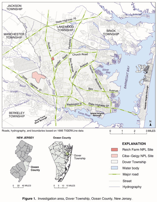
The Agency for Toxic Substances and Disease Registry (ATSDR), an agency of the United States Department of Health and Human Services, under the Comprehensive Environmental Response, Compensation, and Liability Act (CERCLA, also known as Superfund) is required to evaluate the public health threat of hazardous waste sites using environmental characterization data, community health concerns, and health outcome data. In the spring of 1996, ATSDR and the New Jersey Department of Health and Senior Services (NJDHSS) initiated an investigation to address health concerns of the Dover Township, Ocean County, New Jersey, community. In particular, community members expressed the concern that exposure to environmental contaminants from the area’s hazardous waste sites, including two National Priorities List (NPL) or Superfund sites (Figure 1, Plate 14) was related to the elevated incidence of childhood leukemia and brain and central nervous system cancers.
In 1997, NJDHSS and ATSDR began designing a case-control epidemiologic study of childhood cancers that occurred in Dover Township (Berry and Haltmeier 1997). In a case-control study, a population is delineated and cases of diseases arising in that population over a specified time period are identified. The exposure experiences of the case group are compared to the exposure experiences of a sample group of non-diseased persons in the population from which the cases arose. The exposure experiences that are more common among the diseased cases may be considered possible risk factors for the disease (Rothman and Greenland 1998).
The study is exploring multiple possible risk factors, including environmental exposures. ATSDR and NJDHSS have determined that completed human exposure pathways to groundwater contaminants have occurred in the past through private and municipal water supplies in some parts of the Dover Township area community (ATSDR 2001a,b,c,d). Therefore, one of the environmental factors being evaluated is the past exposure to certain previously contaminated drinking-water sources.
To assist with the drinking-water exposure assessment component of the epidemiologic study, ATSDR developed a water-distribution model using the EPANET 2 software (Rossman 2000) to reconstruct historical patterns of water-supply distribution for the period January 1962 through December 1996. The key steps of this historical reconstruction analysis and the location in this report where these key steps are discussed are shown in flow-chart format in figure 2. Owing to the lack of pertinent historical information, particularly the availability of spatially and temporally distributed hydraulic and contaminant-specific data, the water-distribution model was first calibrated to accurately represent present-day (1998) Dover Township area water-distribution system characteristics. Data utilized for this initial calibration were gathered during March and August 1998. The reliability of the calibrated model was tested by using the model to simulate the transport of barium through the water-distribution system. Barium is a naturally occurring, dissolved, conservative element. Simulated barium concentrations were compared to measured concentrations at 21 schools and 6 points of entry to the water-distribution system determined in March and April 1996. Comparison of measured and simulated barium concentrations at the 21 school locations showed a mean relative difference of 13.6%, with the range of differences being 0.6% to 25.6%. Additionally, comparison of the measured and simulated barium concentrations showed a geometric bias of 0.93, indicating a slight under prediction by the model (1.00 indicates perfect agreement), and a correlation coefficient of 0.81, indicating a high agreement between measured concentrations and simulated values. A complete description of the field-data collection activities, model calibration, and reliability test results were described previously in an ATSDR report and technical article (Maslia et al. 2000a,b).
In the second step of the historical reconstruction analysis, and the subject of this report, distribution-system networks were derived from diverse data sources for the historical period of January 1962 through December 1996 (Figure 2). Given the paucity of historical contaminant- specific concentration data during most of the period relevant to the epidemiologic study, ATSDR and NJDHSS decided that modeling efforts should concentrate on estimating the percentage of water that a study subject might have received from each point of entry (well or well fields) to the water-distribution system (Plate 2). Percentage contributions would be determined at monthly intervals during the historical period. This approach uses the concept of "proportionate contribution" described in Maslia et al. (2000a, p. 4) wherein at any given point in the distribution system, water may be derived from one or more sources in differing proportions. The percentage or proportionate contribution of water to locations in the distribution system from points of entry then becomes a surrogate for exposure pathways and exposure intervals. This approach allows epidemiologists to more accurately assess the association between the occurrence of childhood cancers and exposure to each of the sources of potable water entering the distribution system, including those known to have been historically contaminated. A literature review of epidemiologic investigations relating water-supply contamination with health effects is provided in Maslia et al. (2000a, p. 3).
The configuration of the water-distribution system serving the Dover Township area (number of pipelines, wells, storage tanks, and high-service and booster pumps) during the historical period has changed each year (Table 1). For example, the 1962 water-distribution system served nearly 4,300 customers from a population of about 17,200 persons5 (Board of Public Utilities, State of New Jersey 1962) and was characterized for modeling by (Plate 3):
By contrast, in 1996—the last year of the historical reconstruction period—the water-distribution system served nearly 44,000 customers from a population of about 89,300 persons (Board of Public Utilities, State of New Jersey 1996) and was characterized for modeling by (Plate 37):
A summary of the configuration of the water-distribution system serving the Dover Township area during the historical period is provided in Table 1. Some of the data listed in Table 1 are presented and discussed elsewhere in this report in greater detail. For example, the number of pipeline segments and total pipeline miles are presented in Appendix A, and the number of groundwater wells, number of well fields, and the rated capacity of the groundwater wells are presented in Appendix B.
Because this report is considered a companion document to the analysis of the 1998 water-distribution system serving the Dover Township area—previously described by Maslia et al. (2000a)—certain topics such as water-distribution system model development and data input requirements and terminology used by EPANET 2 will not be described or provided herein. Rather, these topics are thoroughly described and discussed in the earlier publication and the reader shouldrefer to that report for details. The focus of the current report includes the following five aspects of the historical reconstruction analysis: (1) data sources and requirements, (2) methods of analysis, (3) simulation strategies, (4) selected simulation results, and (5) the use of sensitivity analysis to address issues of uncertainty and variability of historical system operations.
Because of the scientific complexity and length of this report, some readers may prefer a summary of the analyses presented herein. Accordingly, a "Summary of Findings" report (ATSDR 2001f) has been prepared and released by ATSDR. The summary report provides a simpler and less technical description of the historical reconstruction analysis. Because of the brevity of the "Summary of Findings" report, presentation of some topics, illustrations, and tables may have been modified slightly in comparison to those contained in this comprehensive report. However, all information and conclusions provided in the "Summary of Findings" report are based solely on data and analyses contained herein. The "Summary of Findings" report is also available over the Internet at the ATSDR web site at URL: www.atsdr.cdc.gov.
Contamination of groundwater resources in Dover Township, Ocean County, New Jersey, including public and private water-supply wells, was identified in the 1960s (Toms River Chemical Corporation 1966) and subsequently documented in the 1970s (ATSDR 2001a,b,c,d). Water-quality analyses, conducted since the mid-1980s, indicate that this contamination has generally consisted of volatile organic compounds such as trichloroethylene (TCE) and semi-volatile organic compounds such as styrene-acrylonitrile (SAN) trimer (ATSDR 2001d). The reader is referred to the following reports for a description and analysis of contamination of groundwater resources in the Dover Township area: ATSDR (1988, 1989, 2001a,b,c,d), Malcolm Pirnie, Inc. (1992), Pinder, et al. (1992), and Sykes (1992, 1995, 2000). The primary source of potable water for the area is groundwater and it is withdrawn primarily from the shallow Kirkwood-Cohansey aquifer. To a lesser degree, the deeper Piney Point and Potomac/Raritan/Magothy aquifers are also used as sources for groundwater (Maslia et al. 2000a, Table 1). Approximately 85% of current Dover Township area residents are served by a public water-supply system (as opposed to privately owned domestic wells). Based on public health assessments conducted for the Dover Township area, ATSDR and NJDHSS have determined that completed human exposure pathways to groundwater contaminants have occurred through private and community water supplies (ATSDR 2001a,b,c,d). Therefore, an analysis of the potential for distribution of contaminants through the water-distribution system was deemed necessary as part of the exposure assessment component of the epidemiological study.
Because the focus of the epidemiologic investigation is on children, exposure at residential locations is deemed the most important exposure opportunity to investigate, although other exposure opportunities, such as at schools and other public facilities, may have occurred. Exposure to water sources that study subjects received (well or well fields) from the water-distribution system can be estimated using the results of the historical reconstruction of waterdistribution system operations and residential histories. Given the multiple number of wells and well fields in the distribution system serving the Dover Township area, the ability to track the percentage of water originating from a well or well field was considered a useful analytical tool to help estimate exposure. For the current study, the EPANET 2 water-distribution system model was applied in a diagnostic mode to reconstruct historical water-distribution system operations. Prior to conducting the historical reconstruction analysis phase of the investigation, model simulation results were compared to spatially and temporally varying field measurements in order to better understand and quantify the reliability of model predictions.
Table 1. Water-distribution system configuration, Dover Township area, New Jersey, 1962–96
[Except for number of pipeline segments, all data from annual reports of the Board of Public Utilities, State of New Jersey (1962–96) and Flegal (1997)]
Year |
Pipelines1 |
Groundwater Wells2 |
Storage Tank3 |
Pumps4 |
System Production5 |
||||||
|---|---|---|---|---|---|---|---|---|---|---|---|
|
Number of Pipeline Segments |
Total Length (miles) |
Range of Diameter (inches) |
Number of Wells |
Number of Well Fields |
Total Rated Capacity (gallons per minute) |
Elevated |
Ground Level |
Total Rated Volume (million gallons) |
Number of High Service and Booster |
Peak Month and Rate (million gallons per day) |
1962 |
2,400 |
77 |
2&endash;12 |
3 |
2 |
1,900 |
61 |
61 |
0.45 |
0 |
May, 1.3 |
1963 |
2,700 |
87 |
2&endash;12 |
3 |
2 |
1,900 |
2 |
1 |
0.30 |
0 |
July, 1.6 |
1964 |
3,100 |
93 |
2&endash;12 |
3 |
2 |
1,900 |
1 |
0 |
0.30 |
0 |
June, 2.1 |
1965 |
3,600 |
115 |
2&endash;12 |
4 |
2 |
2,850 |
1 |
0 |
0.30 |
0 |
June, 2.1 |
|
|||||||||||
1966 |
3,900 |
123 |
2&endash;12 |
7 |
5 |
4,400 |
1 |
0 |
0.30 |
0 |
July, 2.9 |
1967 |
4,300 |
135 |
2&endash;16 |
9 |
6 |
5,500 |
2 |
0 |
0.80 |
0 |
June, 3.6 |
1968 |
4,600 |
145 |
2&endash;16 |
9 |
6 |
5,500 |
2 |
2 |
1.85 |
3 |
July, 3.7 |
1969 |
5,100 |
158 |
2&endash;16 |
10 |
6 |
6,200 |
2 |
2 |
1.85 |
3 |
June, 4.9 |
1970 |
5,900 |
182 |
2&endash;16 |
10 |
6 |
6,200 |
2 |
2 |
1.85 |
3 |
July, 4.5 |
|
|||||||||||
1971 |
6,600 |
200 |
2&endash;16 |
14 |
7 |
8,530 |
2 |
3 |
2.85 |
5 |
June, 9.3 |
1972 |
7,000 |
211 |
2&endash;16 |
16 |
7 |
9,650 |
2 |
3 |
2.85 |
5 |
July, 9.7 |
1973 |
7,500 |
227 |
2&endash;16 |
16 |
7 |
9,650 |
2 |
3 |
2.85 |
5 |
July, 8.8 |
1974 |
7,900 |
241 |
2&endash;16 |
16 |
7 |
9,650 |
2 |
3 |
2.85 |
5 |
July, 8.7 |
1975 |
8,300 |
253 |
2&endash;16 |
18 |
7 |
11,050 |
2 |
4 |
3.85 |
6 |
August, 6.9 |
|
|||||||||||
1976 |
8,600 |
260 |
2&endash;16 |
18 |
7 |
11,050 |
2 |
4 |
3.85 |
6 |
June, 9.3 |
1977 |
8,900 |
271 |
2&endash;16 |
17 |
7 |
10,450 |
2 |
4 |
3.85 |
6 |
July, 9.7 |
1978 |
9,400 |
284 |
2&endash;16 |
17 |
7 |
10,450 |
2 |
5 |
4.85 |
7 |
July, 8.8 |
1979 |
9,700 |
295 |
2&endash;16 |
16 |
7 |
9,750 |
2 |
5 |
4.85 |
9 |
July, 8.5 |
1980 |
9,900 |
301 |
2&endash;16 |
19 |
8 |
11,850 |
2 |
5 |
4.85 |
9 |
June, 10.4 |
|
|||||||||||
1981 |
10,200 |
309 |
2&endash;16 |
17 |
7 |
12,200 |
2 |
5 |
4.85 |
9 |
July, 9.3 |
1982 |
10,400 |
315 |
2&endash;16 |
15 |
6 |
11,000 |
2 |
6 |
6.35 |
11 |
July, 8.9 |
1983 |
10,700 |
324 |
2&endash;16 |
16 |
6 |
11,900 |
2 |
6 |
6.35 |
11 |
July, 10.9 |
1984 |
11,300 |
340 |
2&endash;16 |
17 |
7 |
12,200 |
2 |
6 |
6.35 |
11 |
June, 11.0 |
1985 |
11,800 |
354 |
2&endash;16 |
15 |
6 |
11,000 |
2 |
6 |
6.35 |
11 |
July, 10.2 |
|
|||||||||||
1986 |
13,200 |
396 |
2&endash;16 |
17 |
7 |
13,050 |
2 |
6 |
6.35 |
11 |
June, 11.9 |
1987 |
13,400 |
406 |
2&endash;16 |
16 |
7 |
12,250 |
2 |
6 |
6.35 |
11 |
August, 11.5 |
1988 |
14,100 |
427 |
2&endash;16 |
16 |
7 |
12,550 |
2 |
6 |
6.35 |
11 |
July, 14.0 |
1989 |
14,500 |
439 |
2&endash;16 |
17 |
7 |
13,250 |
2 |
6 |
6.35 |
11 |
August, 12.3 |
1990 |
14,600 |
443 |
2&endash;16 |
16 |
7 |
12,900 |
2 |
6 |
6.35 |
12 |
July, 12.2 |
|
|||||||||||
1991 |
14,800 |
448 |
2&endash;16 |
18 |
8 |
15,100 |
2 |
6 |
6.35 |
12 |
July, 11.9 |
1992 |
14,900 |
451 |
2&endash;16 |
18 |
8 |
15,100 |
3 |
6 |
7.35 |
12 |
July, 12.1 |
1993 |
15,100 |
458 |
2&endash;16 |
19 |
8 |
15,350 |
3 |
6 |
7.35 |
12 |
July, 15.1 |
1994 |
15,400 |
467 |
2&endash;16 |
20 |
8 |
16,550 |
3 |
6 |
7.35 |
12 |
June, 15.1 |
1995 |
15,700 |
473 |
2&endash;16 |
20 |
8 |
16,550 |
3 |
6 |
7.35 |
12 |
August, 16.6 |
|
|||||||||||
1996 |
16,000 |
482 |
2&endash;16 |
20 |
8 |
16,550 |
3 |
6 |
7.35 |
12 |
July, 13.9 |
|
1Number of pipeline segments refers to ATSDR water-distribution model; number of segments and total length have been rounded -- see Appendix A for details. |
|||||||||||
PREVIOUS INVESTIGATION
During the earlier phase of this investigation (Figure 2), ATSDR and NJDHSS gathered synoptic, system-wide hydraulic and operational data in March and August 1998 in order to characterize, as completely as possible, the water-distribution system under present-day operating conditions. Results of these field-data collection activities and the water-distribution system model calibration and testing are described in the report, "Analysis of the 1998 Water-Distribution System Serving the Dover Township Area, New Jersey: Field-Data Collection Activities and Water-Distribution System Modeling" (Maslia et al. 2000a). Specifically, this report describes the following activities:
DESCRIPTION OF THE PRESENT -DAY (1998) WATER -DISTRIBUTION SYSTEM
The Dover Township area water-distribution system being analyzed has been operating since 1897 and is currently operated by United Water Toms River, Inc. (UWTR). It serves the residents of Dover Township, New Jersey, and communities outside of Dover Township including the borough of South Toms River and a portion of Berkeley Township (Figure 3, Plate 2). At the end of 1998, the water-distribution system served approximately 45,000 customers from a population of about 94,000 persons. The distribution system consists of (Board of Public Utilities, State of New Jersey 1998):
A list and description of the present-day water-distribution system storage tanks, wells, and high-service and booster pumps serving the Dover Township area is provided in Maslia et al. (2000a, Table 1). As presently configured, 9 wells discharge directly into the distribution system (wells 15, 20, 31-35, 38, 43); whereas, the remaining 14 wells (21, 22, 24, 26, 28, 29, 30, 37, 39, 40, 41, 42, 44, 45) are used to fill storage tanks (such as the Parkway well field ground-level or the North Dover elevated). High-service and booster pumps are used to supply the distribution system with water from the storage tanks. Not all extracted groundwater receives the same treatment. Components of the treatment system may include filters; aeration; and the addition of lime, chlorine, alum, or permanganate. The reason for this treatment is for filtration, pH control, or purification (Board of Public Utilities, State of New Jersey 1998). The type of water treatment and the reason for the treatment by well and well field is listed in Table 2.
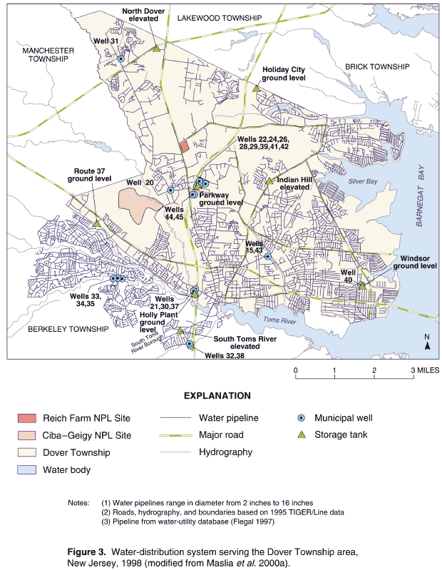
Table 2. Type of water treatment used by the present-day (1998) water-distribution system, Dover Township area, New Jersey
[Data from Board of Public Utilities, State of New Jersey (1998)]
Well or Well Field Name |
Well Number(s) |
Type of Treatment |
Reason for Treatment |
|---|---|---|---|
Holly |
21, 30, 37 |
Filters |
Filtration |
Brookside |
15, 43 |
Filters |
Filtration |
South Toms River |
32, 38 |
Lime |
pH control |
Indian Head |
20 |
Lime |
pH control |
Parkway |
22, 24, 26, |
Aeration |
Purification |
Route 70 |
31 |
Lime |
pH control |
Berkley |
33, 34, 35 |
Lime |
pH control |
Windsor |
40 |
Aeration |
Filtration |
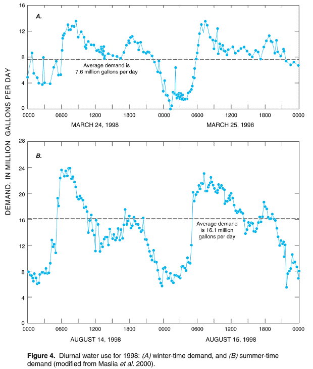
Diurnal or 24-hour demand for water in the Dover Township area, as measured during the 1998 field-data collection activities, is characterized by two typical demand patterns. A minimum- or winter-demand pattern, typical of data collected in March 1998 (Figure 4A), generally occurs from November through mid- May, and a maximum- or summer-demand pattern, typical of data collected in August 1998 (Figure 4B), generally occurs during the summer season from the end of May (Memorial Day) through September. The diurnaldemand patterns obtained from the measured data in 1998 (Figure 4) were used to characterize the historical diurnal-demand patterns for the historical reconstruction analysis. Total water production during the historical period was based on production information obtained from the Board of Public Utilities, State of New Jersey annual reports (1962–1996), NJDHSS data searches (Michael P. McLinden, written communication, August 28, 1997), and water-utility databases (Flegal 1997).
An average demand can be approximated by taking the mean of the minimum- and maximum-demand period data. Based on field data collected in March and August 1998 (Figure 4), the average demand is 11.7 MGD; whereas, the average demand for October 1998 is 11.8 MGD, based on data obtained from the Board of Public Utilities, State of New Jersey (1998). Similar computations using monthly water-production data obtained from the annual reports of the Board of Public Utilities, State of New Jersey (1962–1996) for every month of the historical reconstruction period indicate that October production consistently approximates the average yearly production.
EXTERNAL EXPERT REVIEW
Throughout this investigation, ATSDR has sought external expert input and review of this project. On November 14, 2000, ATSDR convened an external expert panel to review the approach used in conducting the historical reconstruction analysis and to provide input and recommendations on the preliminary modeling results (ATSDR 2001e). The panel was composed of experts with professional backgrounds from government and academia, as well as the private sector. Areas of expertise included numerical model development and simulation, hydraulic and water-quality analysis of water distribution systems, model calibration, and water-distribution system optimization. Panel members considered the modeling approaches—a manual adjustment process which conforms as closely as possible to actual water-distribution system operations, and a Genetic Algorithm (GA) optimization approach. The experts indicated that these two approaches were technically sound given data limitations, and provided the following recommendations for enhancing the modeling approaches and historical reconstruction analysis (ATSDR 2001e):
The recommendations of the external expert panel were implemented as part of the historical reconstruction analysis effort. Results of these efforts are presented in conjunction with specific data needs, descriptions of the historical reconstruction simulations, and sensitivity analyses in the report sections that follow.
A simulation approach to the historical reconstruction of the water-distribution system in the Dover Township area required knowledge of the functional as well as the physical characteristics of the distribution system. Accordingly, six specific types of information were required: (1) pipeline and network configurations for the distribution system; (2) potable water-production data including information on the location, capacity, and time of operation of the groundwater production wells; (3) consumption or demand data at locations throughout the distribution system; (4) storage-tank capacities, elevations, and water-level data; (5) high-service and booster pump characteristic curves; and (6) system-operations information such as the on-and-off cycling schedule of wells and high-service and booster pumps, and the operational extremes of water levels in storage tanks. These data types are discussed in detail in this section of the report.
DISTRIBUTION-SYSTEM NETWORK CONFIGURATIONS
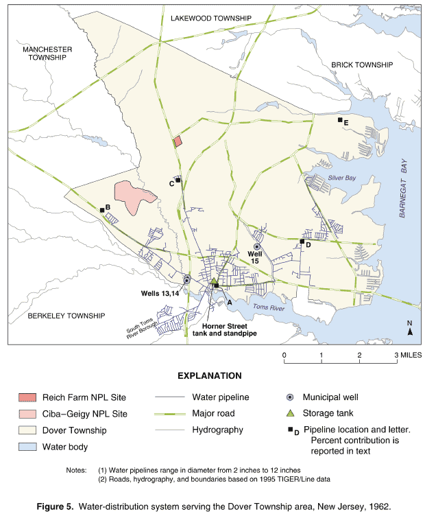
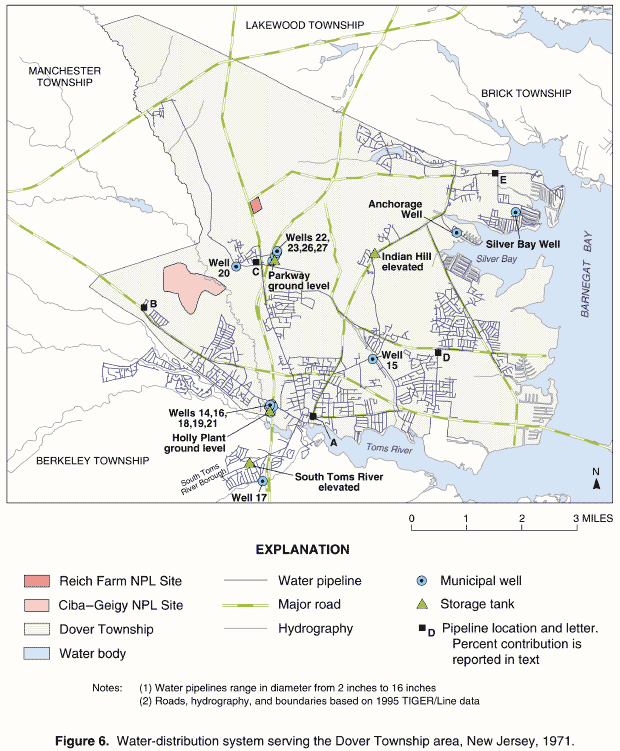
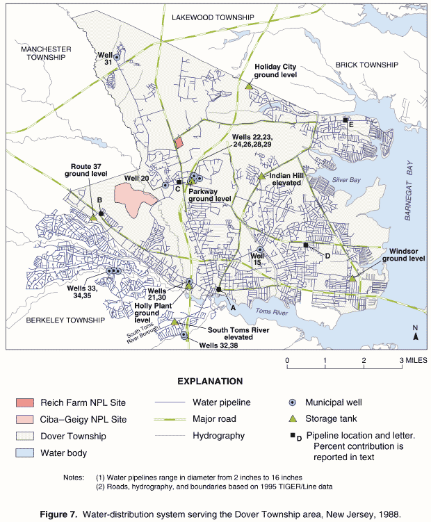
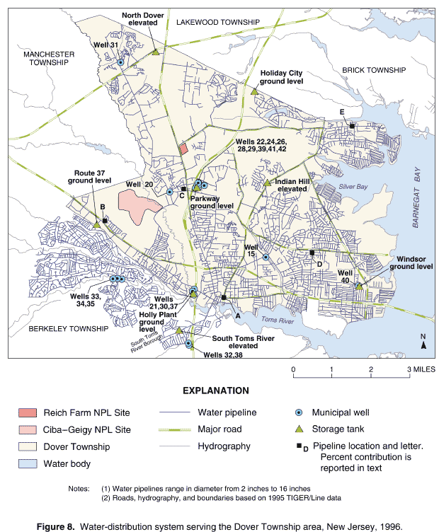
The spatial configuration of the distribution-system networks, pipeline characteristics, and in-service dates of groundwater wells and elevated and ground-level storage tanks were obtained from the water utility (Flegal 1997) and the annual reports of the Board of Public Utilities, State of New Jersey (1962–1996). For the water-distribution system serving the Dover Township area, pipeline, groundwater-well, and storage-tank locations are shown on an annual basis for the historical period of 1962–96 on Plates 3 through 37. Selected examples of historical network configurations for 1962, 1971, 1988, and 1996 are also presented in Figures 5 through 8, respectively.
Pipeline characteristics such as the material type, the year installed, length of pipeline segments, and the range of diameters are listed in Appendix A, Tables A-1 through A-35. Because the pipeline database did not specify the month of installation, an assumption was made that the in-service date for the pipelines was January 1 of the installation year as obtained from the water utility’s database.
Spatial and temporal distributions of waterdistribution system facilities also are illustrated on Plates 3 through 37. Figures 5 through 8 assist in showing that the complexity of the system increased considerably over the time span of the historical period. The distribution system expanded from the south-central area of Dover Township along a northeasterly and northwesterly direction (compare Plates 3 and 7). In 1962, the water-distribution system consisted of three wells and one storage tank and standpipe combination (Figure 5, Plate 3). As storage tanks and groundwater wells were added, these facilities were brought online to meet yearly maximum demand, which occurred from the end of May (Memorial Day) through September. For example:
Therefore, according to the water utility, these additional facilities would have been operational after the end of May 1967 and May 1971, respectively.
To meet increasing demand in the Berkeley Township area, the Route 37 ground-level storage tank was added to the system in 1978 (Plate 19). To supply additional demand occurring in the northwestern area of Dover Township, well 31 (Route 70) was added to the system in 1980 (Plate 21). The Windsor ground-level storage tank was added in 1982 to meet the growing demand in the southeasternmost part of the distribution system (Plate 23). By 1986, customer growth and demand had increased substantially in the Berkeley Township area serviced by the water utility, and two additional supply wells, 33 and 34 (Berkeley) were added (Plate 27). In 1988, well 35 was added to the existing two wells serving the Berkeley Township area (Figure 7, Plate 29), and in 1991, well 40 (Windsor) was added to the system to meet increases in demand in the southeastern part of Dover Township. The last storage tank added to the water-distribution system during the historical period was the North Dover elevated-storage tank, and it was added in 1992 (Plate 33). Additional supply wells were added to the Parkway well field to meet increasing demand in 1993 (well 41, Plate 34) and 1994 (well 42, Plate 35). For the last year of the historical period, 1996, the water-distribution system (Figure 8, Plate 37) closely resembled the present-day system (1998) shown on Figure 3 (Plate 2).
The pipeline data were carefully checked and quality assured. At some locations, duplicate pipeline segments were identified, and at other locations, a few pipeline segments were missing from the original database provided by the water utility. At these locations, pipeline data for several years prior to and after the period of interest were compared in order to reconcile discrepancies. Such data discrepancies, however, generally accounted for less than 1% of all pipeline segments for any one historical year.
The time distribution of total pipeline length by material type and customer served is shown in Figures 9 and 10. The information shown in these figures are also listed in Appendix A. The distribution by year of pipeline material types (Figure 9) is shown as a percentage of total pipeline length. The graph shows that the distribution system is composed of pipelines whose material types are primarily asbestos cement (AC) and plastic (PVC, PE, IPS). The percentage of pipeline segments constructed of other material types, such as cast iron, copper, ductile iron, or galvanized pipe, has historically ranged between 7% in 1962 to about 2% in 1996 of total pipeline segments. After 1980, an increase occurred in the use of plastic pipe with a corresponding decrease in the use of asbestos cement pipe. Year-by-year total pipeline length of the water-distribution system and the corresponding number of customers served are shown in Figure 10. The increase in pipeline length and customers served occurred at a nearly identical rate throughout the historical period. Thus, as the number of customers needing potable water increased from 1962 through 1996, so did the length of the pipelines in the water-distribution system serving those customers.
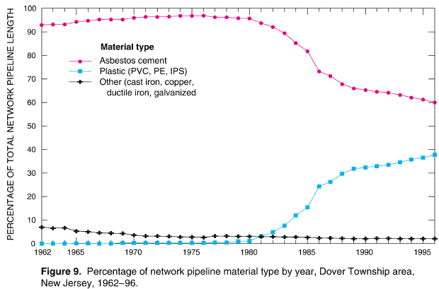
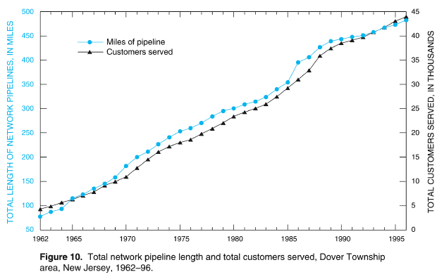
To verify that pipelines located near the ends of the distribution network were in use and delivering water to customers (as opposed to being constructed in anticipation of future use), historical aerial photographs of the Dover Township area were obtained from the Ocean County, New Jersey, Planning Board (Scott M. Cadigan, written communication, December 4, 2000) and from IntraSearch, Inc. (Jerry T. Flickinger, written communication, July 11, 2001). Eight of the photographs shown in this report (Plates 38–45) are overlain with water pipelines and other features in the Dover Township area for 1963, 1965, 1968, 1972, and 1976.
The aerial photographs reproduced on Plates 38 and 39 show areas serviced by the water utility during 1963. The photographs were taken in June 1963 and show the central (Plate 38) and west-central (Plate 39) areas of Dover Township. Houses and buildings can be seen in the photographs along the water pipelines at the ends of the pipeline network. These photographs provided evidence that, in 1963, the water-distribution system was servicing customers located near the ends of the network pipelines.
The aerial photographs reproduced on Plates 40 and 41 show the areas serviced by the water utility during 1965. The photographs, taken in April 1965, show the central area (Plate 40) and northeasternmost area (Plate 41) of Dover Township. Houses and buildings can be seen along and near the ends of the water pipelines. Such associations provide additional photographic evidence that the water-distribution system was servicing customers in 1965 located near the ends of the pipeline network.
The aerial photograph reproduced on Plate 42 shows the southwestern area of Dover Township serviced by the water utility during 1968. Houses located next to the water pipelines can clearly be seen in the photograph, thereby providing additional photographic evidence that the water pipelines were servicing these residences in response to demand.
An aerial photograph of the northern area of Dover Township, taken in April 1972, is reproduced on Plate 43. Overlain on the photograph are water pipelines showing the northern extent of the pipeline network. Residential communities can clearly be seen in this area being serviced by the northern extremities of the pipeline network.
Aerial photographs for the northeasternmost and western parts of Dover Township are reproduced on Plates 44 and 45, respectively, and are overlain with the 1976 water pipelines. Residences and buildings can be clearly seen next to the water pipelines at the extremities of the pipeline network, again providing photographic evidence that customers near the ends of the pipeline network were being serviced by the water utility. Furthermore, the photographs reproduced on Plates 44 and 45 show residences and buildings located beyond the extent of the 1976 pipeline network. Plates 44 and 45 provided photographic evidence that demand for water existed in these locations prior to the extension of the pipeline network to service customers. After reviewing aerial photographs like the ones reproduced on Plates 38 through 45, and following discussions with water-utility managers, ATSDR investigators concluded that the network of water pipelines was expanded based upon existing demand, rather than constructing water pipelines in anticipation of demand. Thus, for the historical reconstruction analysis, it was assumed that all pipeline segments at the extremities of the water-distribution system were delivering water to customers to meet demand.
PRODUCTION DATA
Water-production data—volumes produced and hours of operation for groundwater wells—were gathered, aggregated, and analyzed for each well for every month of the historical period (420 months), and these data are listed in Appendix B (Tables B-1 through B-35). Production data were obtained from the water utility (Flegal 1997), annual reports of the Board of Public Utilities, State of New Jersey, (1962–1996), and NJDHSS (Michael P. McLinden, written communication, August 28, 1997). Well-production volumes were measured using in-line flow meters at water-supply wells (George J. Flegal, Manager, United Water Toms River, Inc., oral communication, August 28, 2001). Also listed in Tables B-1 through B-35 are well-identification numbers, the rated capacity of wells, the gallons of water the wells produced each month of the year, and the average number of hours each day a well operated. To determine the average number of hours each day a well operated, the following formula was used:

where:
Tavg = average times a well was operated, in hours per day;
QP = production of water, in gallons per month;
Cw = rated capacity of the well, in gallons per minute;
Tm = number of minutes per hour (60); and
Td = number of days per month (28, 29, 30, or 31).
For each well listed in the tables in Appendix B, the top row provides the reported gallons of water produced for a particular month and the bottom row indicates the average number of hours each day a well operated for the particular month, determined by applying Equation (1). The estimation of the average hours per day that a well was operated (Tavg) was based on the assumption that the well operated at its rated capacity.
Upon reviewing the data in Appendix B, the minimum production month is typically February, the average (or mean) production month is typically October, and the maximum (or peak) production month is either May, June, July, or August. Figure 11 is a graphical summary of the production data in Appendix B for each year of the historical period (1962–96). The graph shows the minimum, mean, and maximum production for each year as a series of bars. The production values shown on the graph were derived by dividing the monthly production data (Tables B-1 through B-35) by the number of days in the month in which the minimum, mean, or maximum production occurred. For example, total water-distribution-system production for February 1964 was 30,432,000 gal of water (Table B-3). Dividing the production by 29 (the number of days in the month for February 1964) provides a value of 1.0 Mgal which is the value of the minimum-value bar for 1964 in Figure 11. Minimum and mean production values generally show increases of similar rates throughout the historical period. However, the maximum production for certain years peaks or "spikes" noticeably throughout the historical period (for example, 1971, 1980, 1988, and 1995), as shown on Figure 11.
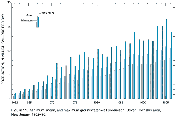
Monthly production data also can be represented graphically as shown in a three-dimensional plot (Figure 12). Referring to this plot, the x-axis is the year (1962–96), the y-axis is the month (January–December), and the z-axis is the total monthly production in million gallons. Maximum production of water is shown to occur in the months of May, June, July, or August. In addition, considerable production increases are shown to have occurred in 1971, 1988, and 1995. These years are characterized on the plot by sharp peaks. The graph also shows that a small peak occurred in November 1989 when production for the month increased substantially (see Table B-28).
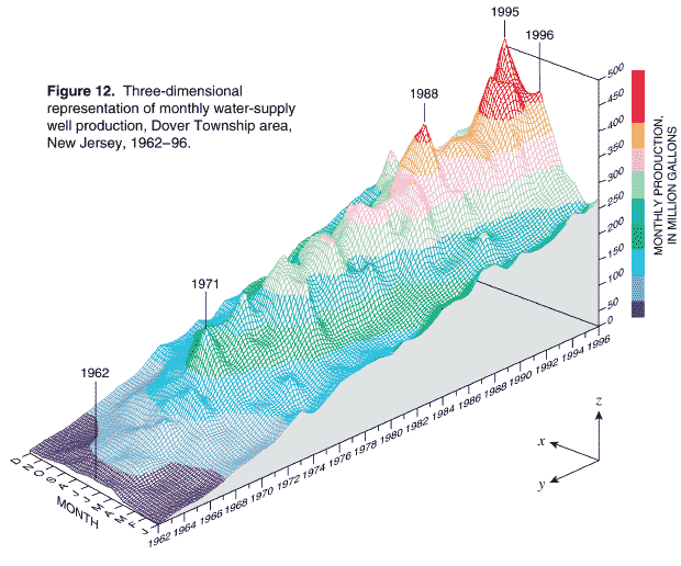
As previously discussed, the rated capacity of the groundwater wells that historically were used for production was required to compute the average number of hours each day a well operated (Equation [1]). The rated capacity for each well that historically was part of the water-distribution system is also listed in Tables B-1 through B-35. These data are summarized in Figure 13 as a series of bars, with each bar representing the total rated capacity of all wells in the water-distribution system for each year of the historical period.
Data listed in the tables of Appendix B are grouped by well number and well field or points of entry to the water-distribution system (for example, Holly wells, Parkway wells, Berkeley wells). Using production data in Tables B-1 through B-35, the percentage of water produced by each well field (or individual well such as well 15 (Brookside), well 20 (Indian Head), well 31 (Route 70), Silver Bay well, and Anchorage well) relative to the total production of water for each year of the historical period was computed. The percentage of production is shown in Figure 14 as a series of pie charts, with each pie chart representing the total production in million gallons for each year of the historical period. The size of the individual pie chart is proportional to the total annual production. The different slices of a pie chart represent the percentage of water produced by a well or well field for a given year. Using information in Figure 14, relative changes over time in the production of water from all well and well fields to the water-distribution system can be determined. For example:
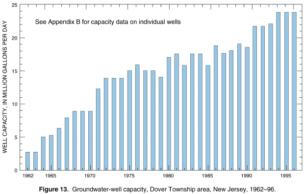
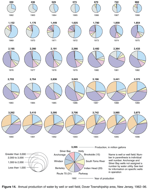
The percentage of the total annual production of water listed in these examples was estimated by inspection of the pie charts in Figure 14. For a more precise derivation of the percentage of production of water by well or well field, readers should refer to the production data listed in Tables B-1 through B-35 and compute the percentages using these data.
ESTIMATION AND DISTRIBUTION OF HISTORICAL CONSUMPTION
For the purpose of the historical reconstruction analysis, the total monthly well production described previously (Tables B-1 through B-35) is considered also to represent total water consumption6. Water-consumption data applied to the EPANET 2 model, however, are not total consumption data, but a component or fractional part of total consumption at each pipeline junction or node of the pipeline network7. Each pipeline node represents a demand point within the pipeline network8. The sum of the component demands applied at each pipeline node for each of the 420 months of the historical period equals the total production for that month. A total of 2,272 nodes were used to represent the pipeline network in 1962 (Table A-1). By 1996, the number of nodes needed to represent the pipeline network had increased to 14,965 (Table A-35). A unique feature of the historical reconstruction analysis is the methods and approaches developed to spatially distribute a component of total monthly production to these nodes9. These methods and approaches are described in the following pages.
Data for historical consumption necessary for simulation consisted of two components—monthly volumes (quantity) and spatial distribution (location). Metered consumption data (quantity and location), obtained from the water utility, were available solely for the presentday (1998) water-distribution system on a quarterly basis for October 1997 through April 1998 (Maslia et al. 2000a, p. 34). Details of the allocation of 1997–98 metered consumption to model nodes are described in the aforementioned report. The spatial distribution of demand at pipeline junctions for the 1998 pipeline network is shown on Plate 7 of Maslia et al. (2000a). Values of metered consumption for the 1998 water-distribution system assigned to individual nodes ranged from 0.001 gpm to about 9.0 gpm with a mean of about 0.4 gpm. To complete the historical reconstruction analysis, the demand at each node for each of the 420 months of the historical period (1962–96) was required. With the exception of the present-day (1998) system, metered data or any other type of demand-point consumption were unavailable. Therefore, some method of estimating both the volume and the spatial distribution of consumption for each historical pipeline network on a monthly basis was required.
Estimation of Historical Consumption
A hypothetical present-day distribution-system network is shown in Figure 15. The total production or supply to the system (QP) is known, and data describing total consumption and its allocation throughout the distribution-system network (point-demand values at pipeline nodes) are available from billing records and field observations. That total production must equal total consumption is also a requirement of the water-distribution system and, for this example, is assigned at a rate of 10gpm. Therefore, the following conditions must apply:
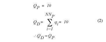
where:
QP = total well production (obtained from well production data), in gallons per minute,
qi = demand at node i (estimated from metered billing records), in gallons per minute,
Qd = total of nodal (customer) demand, in gallons per minute,
NNP = total number of demand nodes in the present-day network.
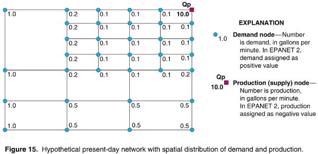
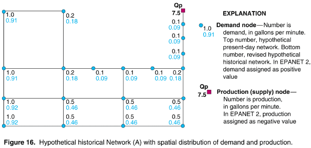
A hypothetical historical distribution-system network (Network (A)) is shown in Figure 16. A comparison of the historical Network (A) with the present-day network (Figures 15 and 16) indicates that the historical network has fewer pipelines and nodes than the presentday network. Total production (QP) for the historical Network (A) is known and is assigned at 7.5 gpm (Figure 16). Accordingly, total production, and thus total demand for the historical network, are known. What must be estimated are the demand-point values at the historical network nodes. In Figure 16, the top number at each of the nodes is the present-day point demand (compare Figure 16 with Figure 15). Note, that the sum of the present-day demand values using the remaining nodes of historical Network (A) is 8.2 gpm (top numbers in Figure 16). To estimate the historical demand (bottom numbers at the nodes in Figure 16) consider the following:
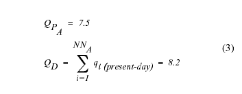
where:
QPA = well production for historical Network (A), in gallons per minute, and
NNA = total number of demand nodes in historical Network (A).
However, the sum of the nodal demands (QD) for historical Network (A) must equal the production (QPA) for Network (A). Therefore, the present-day nodal demands (top numbers in Figure 16) are reduced in value by the ratio of the historical Network (A) production to the remaining present-day nodal demands (QPA / QD = 7.5/8.2), or:
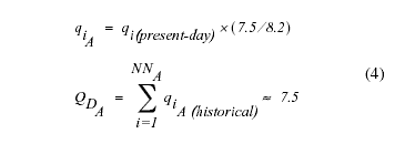
where:
qiA = historical demand at node i for Network (A) in gallons per minute, and
QDA = total historical nodal (customer) demand for Network (A), in gallons per minute.
The estimated nodal values of demand for historical Network (A) are shown in Figure 16 (bottom numbers at each node). The sum of all point demands at these nodes is now equal to the historical production of 7.5 gpm. It should be noted, that because of numerical rounding, some minor adjustments were made to individual nodal values after multiplying by the ratio of (7.5/8.2) so that the sum of all the nodal demand values exactly equaled the production of 7.5 gpm.
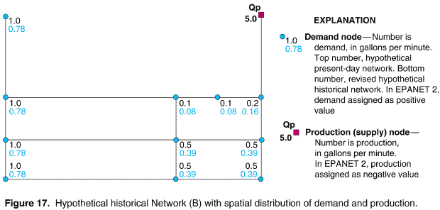
An alternative historical distribution-system network, hypothetical Network (B) is shown in Figure 17, which, for these purposes, is assumed to have existed prior to historical Network (A). Comparison of historical Network (B) with historical Network (A) (Figures 17 and 16, respectively) indicates that Network (B) contains fewer pipelines and fewer nodes than Network (A). To estimate the consumption, the same procedure described previously is applied, except that historical Network (B) is used. Note that in the estimation procedure, for each historical network (whether hypothetical or actual), the initial demand values at the nodes (prior to modification) are always the ones associated with the present-day system (Figure 15). This condition is applied because present-day demands were the only available measured (or metered) demand values. Applying the demand estimation procedure described previously to Network (B), the total well production (QP) is assigned as 5.0 gpm. In Figure 17, the top number at each of the nodes is the original hypothetical present day nodal demand (Figure 15). Note, that the sum of the present-day demand values using the remaining nodes of historical Network (B) is 6.4 gpm (top numbers at the nodes in Figure 17). To estimate the historical demand (bottom numbers at the nodes in Figure 17) consider the following:
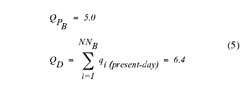
where:
QPB = well production for Network (B), in gallons per minute, and
NNB = total number of demand nodes in historical Network (B).
However, the sum of the nodal demands (QD) for historical Network (B) must equal the well production (QPB) for Network (B). Therefore, the present-day nodal demands (top numbers in Figure 17) are reduced in value by the ratio of the historical production to the remaining present-day nodal demands (QPB / QD = 5.0/6.4), or:
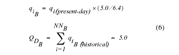
where:
qiB = historical demand at node i for Network (B) in gallons per minute, and
QDB = historical nodal (customer) demand for Network (B), in gallons per minute.
The revised nodal values of demand for Network (B) are the bottom numbers at each node, shown in Figure 17. The sum of these nodes is now equal to the historical production of 5.0 gpm. Because of numerical rounding, some minor adjustments were made to individual nodal values after multiplying by the ratio of (5.0/6.4) so that the sum of all the nodal demand values exactly equaled the production of 5.0 gpm. The estimation procedure described above and exemplified using Network (A) and Network (B) was applied to each historical distribution-system network for the Dover Township area (Plates 3–37) to derive demand-point values of consumption at pipeline nodes for each of the 420 months of the historical period (1962–96).
Distribution of Historical Consumption
The procedure for estimating the nodal distribution of consumption presented above assures that flow balance is preserved (that is, input equals output or total groundwater-well production equals total customer demand). However, underlying this method is the critical assumption that the spatial distribution of nodal demand for any historical pipeline network will be proportional to, if not the same as, the distribution of demand for the present-day (1998) network. Such an assumption does not account for changes in land-use patterns during the historical period. Accordingly, if a certain area of town in 1998 was designated residential in terms of water demand, and if that area of town was serviced by the historical water-distribution system, would the historical pattern also have been residential, or would the historical demand for water have been characterized by a different land-use pattern, such as industrial or rural? As previously discussed, the historical distribution of consumption was unknown. Therefore, an additional analysis was required to establish the validity of the assumption that land-use patterns, and thus demand for water for a particular area or for a particular group of pipeline nodes, did not change significantly over time in the Dover Township area.
A review of land-use classification and related land-use data is a reasonable method of classifying water-demand patterns over time. If land-use classification for a particular area changed historically (for example, from residential to industrial), then the water demand and the distribution of water demand would probably reflect that change. Historical land-use classification and zoning maps for Dover Township were readily available for the period 1957 to 1999.
A search for land-use classification and zoning maps by the staff of Eastern Research Group, Inc. (Leonard Young, written communication, March 21 and April 23, 2001) resulted in ATSDR obtaining land-use classification and zoning maps for Dover Township for the following years: 1957, 1967, 1978, 1990, and 1999. These land-use classification and zoning maps were specifically for Dover Township proper and did not include areas outside of Dover Township serviced by the water utility (for example, areas of Berkeley Township and the Borough of South Toms River; see Plate 2). However, because the areas outside of Dover Township proper serviced by the water utility constitute a relatively small percentage of the overall pipeline network, omitting these areas from consideration (owing to lack of data) did not compromise the analysis.
A total of eight classifications of land-use or zoning types that historically characterized Dover Township were portrayed on the specified maps: (1) central business district; (2) highway business; (3) hospital-medical service; (4) industrial; (5) office; (6) planned retirement community; (7) residential; and (8) rural (Table 3; Plates 46–51). In order to determine land use for each positive-demand node during the historical period, a land-use classification associated with a particular land-use map was assigned to each demand node based on its location along the pipeline network. Once this was accomplished, a comparative analysis was conducted between the present-day (1998) system (for which both metered consumption and land-use classification data were available) and the historical pipeline networks to determine if the land-use classification at demand nodes during the historical period remained consistent or changed significantly. The pipeline networks and land-use classification and zoning map associations used in this analysis are listed below:
The association between pipeline nodes and land-use classification could be firmly established for 1998 conditions and, thus, provided a present-day condition to which the other historical pipeline networks and related land-use map classifications were compared.
The land-use maps were digitized in order to create databases suitable for analyses using a geographic information system (GIS). Using these digital databases, land-use and zoning classifications were assigned to specific polygons or areas of land in Dover Township using the GIS. For each year that land-use classification and zoning maps were available, a spatial digital database of demand nodes and related land-use classifications was created. A spatial analysis technique known as a "spatial join"10 was then applied to each database to assign all pipeline nodes a specific land-use classification. In the spatial join operation, any positive-demand node that fell completely within a particular land-use classification area, or polygon, was assigned the polygon’s land-use classification attribute. This procedure was used for each of the land-use and associated pipeline networks described above. Results of this part of the analysis are presented as a series of maps (Plates 46–51) that show the areal distribution of land-use classification assigned to pipeline nodes for the years 1998, 1990, 1978, 1967, and 1962, respectively. Each positive demand node displayed on the maps is assigned a color based on one of the eight previously specified land-use classifications. The three predominate land-use classifications that consistently appear are "Residential," "Planned Retirement Community," and "Highway Business." A qualitative assessment Plates 46 through 51 indicates that the spatial distribution of land use is highly consistent or nearly consistent throughout the historical period. To quantify this observation, a comparative analysis was undertaken using the positive-demand nodes displayed on Plates 46 through 51.
To conduct the comparative analysis, the total number of positive-demand nodes in the 1998 network within the boundaries of Dover Township was determined and demand statistics were computed (total, maximum, and minimum). Results of this analysis are presented in Table 3. Next, through the use of the GIS querying function, the number of positive-demand nodes and demand statistics for each of the eight land-use classifications was determined for the 1998 distribution-system network. In Table 3, the sum of the nodes (in the "Number of nodes" row) for all land-use classifications equals the number of nodes listed under the "Total Network" heading, and the sum of demand (in the "Total demand, gpm" row) for all land-use classifications equals the demand under the "Total Network" heading.
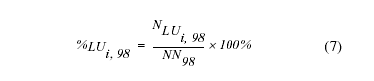
where:
%LUi, 98 = the percentage of positive-demand nodes for the ith land-use classification in 1998 (1 = 1, ..., 8),
NLUi, 98 = the total number of positive-demand nodes for the ith land-use classification, in 1998, and
NN98 = total number of positive-demand nodes in the 1998 pipeline network that occurred within the boundaries of Dover Township.
Values in the "Percent demand" row for the 1998 network were computed using the following formula:
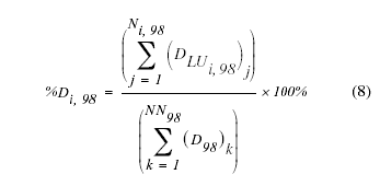
where:
%Di,98 = the percentage of positive-demand nodes for the ith land-use classification in 1998 (1 = 1, ..., 8),
DLUi, 98 = demand, in gallons per minute, for nodes assigned the ith land-use classification, summed for the total number of positive-demand nodes (j = 1, ..., Ni,98) in the ith land-use classification in 1998,
D98 = demand, in gallons per minute, in the 1998 pipeline network summed for the total number of positive-demand nodes (NN98) that occurred within the boundaries of Dover Township, and
Ni,98 = the total number of positive-demand nodes assigned the ith land-use classification in 1998 that occurred within the boundaries of Dover Township.
The values in the "Percent nodes" and the "Percent demand" rows thus computed for the 1998 pipeline network, were used as the basis for comparison when similar computations were applied to specified historical networks. Note, that these values and the related percentages refer only to that portion of the 1998 network that existed within the political boundaries of Dover Township.
In Table 3, nodes assigned a land-use classification of "Residential" in 1998 account for 80% of the positive-demand nodes and 82% of the total demand; nodes assigned a land-use classification of "Planned Retirement Community" account for about 9% of the positive-demand nodes and about 8% of total demand; nodes assigned a land-use classification of "Highway-Business" account for about 5% of the positive-demand nodes and about 5% of total demand. Thus, three land-use classifications account for about 94% of the positive-demand nodes assigned to the 1998 pipeline network and about 95% of the total network demand. This finding is consistent with observations from Plate 46 that portray the areal distribution of positive-demand nodes for the 1998 water-distribution system.
Table 3. Land-use classification analysis for present-day (1998) and historical pipeline networks, Dover Township, New Jersey1
[gpm, gallons per minute; — not applicable]
|
Network Total |
Central Business District |
Highway Business |
Hospital-Medical Service |
Industrial |
Office |
Planned Retirement Community |
Residential |
Rural |
|---|---|---|---|---|---|---|---|---|---|
|
|||||||||
1998 (Present-Day) Network2 |
|||||||||
Number of nodes3 |
9,595 |
27 |
505 |
4 |
63 |
144 |
838 |
7,697 |
317 |
Total demand, gpm |
4,048.0 |
8.7 |
190.2 |
0.5 |
22.1 |
53.5 |
311.8 |
3,319.0 |
142.3 |
Maximum demand, gpm |
9.0 |
1.2 |
9.0 |
0.2 |
1.2 |
3.2 |
1.6 |
6.1 |
6.0 |
Minimum demand, gpm |
0.001 |
0.01 |
0.003 |
0.02 |
0.004 |
0.01 |
0.01 |
0.001 |
0.01 |
Percent nodes4 |
— |
0.3 |
5.3 |
0.0 |
0.7 |
1.5 |
8.7 |
80.2 |
3.3 |
Percent demand5 |
— |
0.2 |
4.7 |
0.0 |
0.6 |
1.3 |
7.7 |
82.0 |
3.5 |
1996 Network6 |
|||||||||
Number of nodes3 |
9,582 |
27 |
505 |
4 |
63 |
144 |
826 |
7,696 |
317 |
Total demand, gpm |
4,042.2 |
8.7 |
190.2 |
0.5 |
22.1 |
53.5 |
307.0 |
3,317.9 |
142.3 |
Maximum demand, gpm |
9.0 |
1.2 |
9.0 |
0.2 |
1.2 |
3.2 |
1.6 |
6.1 |
6.0 |
Minimum demand, gpm |
0.001 |
0.01 |
0.003 |
0.02 |
0.01 |
0.01 |
0.01 |
0.001 |
0.01 |
Percent nodes7 |
99.9 |
0.3 |
5.3 |
0.0 |
0.7 |
1.5 |
8.6 |
80.3 |
3.3 |
Percent demand8 |
99.9 |
0.2 |
1.4 |
0.0 |
0.6 |
1.3 |
7.6 |
82.1 |
3.5 |
1990 Network9 |
|||||||||
Number of nodes3 |
8,619 |
26 |
476 |
4 |
56 |
145 |
535 |
7,089 |
288 |
Total demand, gpm |
3,714.6 |
8.6 |
164.7 |
0.5 |
18.3 |
61.7 |
219.0 |
3,107.3 |
134.4 |
Maximum demand, gpm |
6.1 |
1.2 |
5.8 |
0.2 |
1.5 |
4.1 |
1.6 |
6.1 |
0.01 |
Minimum demand, gpm |
0.001 |
0.01 |
0.003 |
0.02 |
0.002 |
0.01 |
0.2 |
0.001 |
0.01 |
Percent nodes7 |
89.8 |
0.3 |
5.5 |
0.1 |
0.7 |
1.7 |
6.2 |
82.3 |
3.3 |
Percent demand8 |
91.8 |
0.2 |
4.4 |
0.0 |
0.5 |
1.7 |
5.9 |
83.7 |
3.6 |
1978 Network10 |
|||||||||
Number of nodes3 |
5,928 |
105 |
297 |
7 |
82 |
88 |
370 |
4,933 |
52 |
Total demand, gpm |
2,512.8 |
49.5 |
89.2 |
2.7 |
29.7 |
49.2 |
145.3 |
2,099.8 |
47.4 |
Maximum demand, gpm |
6.1 |
1.7 |
3.7 |
1.1 |
1.5 |
6.1 |
1.5 |
3.1 |
6.0 |
Minimum demand, gpm |
0.003 |
0.2 |
0.01 |
0.02 |
0.1 |
0.9 |
0.1 |
0.1 |
1.5 |
Percent nodes7 |
61.8 |
1.8 |
4.9 |
0.1 |
1.4 |
1.5 |
6.2 |
83.2 |
0.9 |
Percent demand8 |
62.1 |
2.0 |
3.6 |
0.1 |
1.2 |
2.0 |
5.8 |
83.6 |
1.9 |
1967 Network11 |
|||||||||
Number of nodes3 |
3,169 |
92 |
172 |
—12 |
52 |
—12 |
209 |
2,612 |
27 |
Total demand, gpm |
1,346.5 |
38.8 |
52.8 |
—12 |
22.6 |
—12 |
86.9 |
1,132.6 |
12.8 |
Maximum demand, gpm |
3.7 |
1.7 |
3.7 |
—12 |
1.6 |
—12 |
1.5 |
3.0 |
1.2 |
Minimum demand, gpm |
0.003 |
0.1 |
0.003 |
—12 |
0.01 |
—12 |
0.02 |
0.01 |
0.1 |
Percent nodes7 |
33.3 |
3.1 |
5.4 |
—12 |
1.6 |
—12 |
6.6 |
82.4 |
0.9 |
Percent demand8 |
33.3 |
2.9 |
3.9 |
—12 |
1.7 |
—12 |
6.5 |
84.1 |
1.0 |
1962 Network13 |
|||||||||
Number of nodes3 |
1,688 |
65 |
102 |
—12 |
115 |
10 |
—12 |
1,396 |
—12 |
Total demand, gpm |
711.9 |
27.0 |
29.4 |
—12 |
50.6 |
4.2 |
—12 |
600.7 |
—12 |
Maximum demand, gpm |
2.9 |
1.7 |
2.2 |
—12 |
0.4 |
0.9 |
—12 |
2.9 |
—12 |
Minimum demand, gpm |
0.01 |
0.01 |
0.01 |
—12 |
0.01 |
0.03 |
—12 |
0.01 |
—12 |
Percent nodes7 |
17.6 |
3.9 |
6.0 |
—12 |
6.8 |
0.6 |
—12 |
82.7 |
—12 |
Percent demand8 |
17.6 |
3.8 |
4.1 |
—12 |
7.1 |
0.6 |
—12 |
84.4 |
—12 |
|
1Does not include Berkeley Township and Borough of South Toms River areas serviced by water utility. |
|||||||||
The next step in the comparative analysis was to repeat the computations described above using the digital land-use classification and related demand-node databases for the historical networks (1996, 1990, 1978, 1967, and 1962). For these networks, and for the related entries in Table 3, the "Percent nodes" and "Percent demand" values in the "Total Network" column were computed relative to the number of positive-demand nodes and the related demand computed for each land-use classification for the 1998 pipeline network. For example (Table 3):
For each of the land-use classification columns and for each historical pipeline network listed in Table 3, the "Percent nodes" and "Percent demand" were computed using the following formulas:
where:
%LUi,j = percentage of positive-demand nodes for the ith land-use classification and for the jth historical network, (1 = 1, ..., 8; j = 1996, 1990, 1978, 1967, 1962),
NLUi,j = total number of positive-demand nodes for ith land-use classification and for the jth historical network,
NNj = total number of positive-demand nodes in the jth historical pipeline network that occurred within the boundaries of Dover Township.
"Percent demand":
where:
%Di,j = the percentage of positive-demand nodes for the ith land-use classification and the jth historical network, (1 = 1, ..., 8; j = 1996, 1990, 1978, 1967, 1962),
DLUi,j = demand, in gallons per minute, for nodes assigned the ith land-use classification for the jth historical network, summed for the total number of positive-demand nodes in the ith land-use classification for the jth historical network (NNi,j)
Dj = demand, in gallons per minute, in the jth historical pipeline network summed for the total number of positive-demand nodes (NNj) that occurred within the boundaries of Dover Township, and
NNi,j = the total number of positive demand nodes assigned the ith land-use classificiation for the jth historical pipeline network that occurred within the boundaries of Dover Township.
The results of these computations for the historical pipeline networks are summarized in Table 3. For the "Residential" land-use classification, the "Percent nodes" ranges between 80% and 83% for all historical networks, and the corresponding "Percent demand" ranges between 82% and 84%. The "Percent nodes" and "Percent demand" for the "Planned Retirement" land-use classification range between about 6% and 9% for all historical networks. (This land-use classification is not present for the earliest historical network, 1962.) For the "Highway Business" land-use classification, the "Percent nodes" and "Percent demand" range between about 4% and 6% for all historical networks. Note that the "Industrial" and "Central Business District" land-use classifications, that potentially could have significantly altered the historical distribution of demand, comprise an insignificant part of the overall historical demand distribution both in terms of the number of pipeline nodes and the magnitude of demand. Thus, the major land-use classification types, "Residential," "Highway Business," and "Planned Retirement Community," have historically and consistently constituted approximately 90% or more of positive-demand nodes and total system-wide demand based on those nodes located within the boundaries of Dover Township. Note, because of similar water-use practices, the "Planned Retirement Community" land-use classification could have reasonably been combined with the "Residential" land-use classification, rather than considered as a distinct classification.
As stated above, the land-use classification analysis was not conducted for areas serviced by the water utility that were outside the Dover Township boundary (portions of Berkeley Township and the Borough of South Toms River) because land-use classification and zoning maps were not available for these areas. Historically, these areas have been residential in their land use, being primarily used for single family residences such as retirement (adult) communities. Therefore, had land-use classification and zoning maps been available to investigators, pipeline demand nodes located in these areas also would have been assigned a "Residential" or "Planned Retirement Community" land-use classification.
This land-use classification analysis has established that the 1998 distribution of demand—based on land-use classification that is spatially consistent through time—historically, is probably a good estimator for the spatial distribution of demand. Based on these results, monthly databases of demand quantity (volume) and demand distribution (location) were developed for the entire historical reconstruction analysis period, 1962–96.
HIGH-SERVICE AND BOOSTER PUMP CHARACTERISTIC CURVES
High-service and booster pumps are used to raise the hydraulic head of water and increase the pressure in certain parts of the water-distribution system. The representation of these pumps in EPANET 2 is described in the Users Manual and requires data derived from pumpcharacteristic curves. Characteristic curves specific to the water-distribution system serving the Dover Township area were derived from data supplied by the water utility and from model calibration, and are described in detail in Maslia et al. (2000a). Pump-characteristic curve data in Maslia et al. (2000a) are provided in both tabular and graphical format. The reader is referred to these aforementioned reports for additional details. In a subsequent section of this report, ("Methods of Analysis and Approach to Simulation"), the representation of high-service and booster pumps in the historical waterdistribution system networks is described in the context of model design and simulations.
SYSTEM OPERATIONS
To simulate the distribution of water for each of the 420 months of the historical period, information regarding the on-and-off cycling of wells and high-service and booster pumps is required. This operations information is input to the EPANET 2 program in the form of "Pattern" and "Pump Control" data (Rossman 2000; Maslia et al. 2000a, pp. 38-41). Prior to 1978, operational data were unavailable and thus, an alternative approach was required to determine system-operation parameters. The approach selected for this study was the development of "Master Operating Criteria" (Table 4).
Table 4. "Master Operating Criteria" used to develop operating schedules for the historical water-distribution system, Dover Township area, New Jersey
Parameter |
Criteria |
|---|---|
Pressure1 |
Minimum of 15 pounds per square inch, maximum of 110 pounds per square inch at pipeline locations, including network end points |
Water level |
Minimum of 3 feet above bottom elevation of tank; maximum equal to elevation of top of tank; ending water level should equal the starting water level |
Hydraulic device online date |
June 1 of year installed to meet maximum-demand conditions |
On-and-off cycling: Manual operation |
Wells and high-service and booster pumps cannot be cycled on-and-off from 2200 to 0600 hours |
On-and-off cycling: Automatic operation |
Wells and high-service and booster pumps can be cycled on-and-off at any hour |
Operating hours |
Wells should be operated continuously for the total number of production hours, based on production data2 |
|
1Generally, for residential demand, minimum recommended pressure is about 20 pounds per square inch. However, for some locations in the Dover Township area (mostly in areas near the end of distribution lines) lower pressures were simulated. |
|
The "Master Operating Criteria" are explicit conditions and standards based on hydraulic engineering principles necessary to successfully operate water-distribution systems similar to the one serving the Dover Township area. From 1978 forward, for selected years, operators of the water utility provided information describing generalized operating practices for a typical "peak-demand" (summer) and "non-peak demand" (fall) day. These guidelines were used in conjunction with the "Master Operating Criteria" to simulate a "typical" 24-hour daily operation of the water-distribution system. Prior to 1978, however, only the "Master Operating Criteria" were used to simulate system operations.
Using the "Master Operating Criteria" (Table 4) as guidelines, a 24-hour operating schedule was developed for each month of the historical period. Daily operational variations including routine maintenance of system facilities, repair of pipeline breaks, emergency fire service, and other temporary interruptions of routine operations over a "typical" 24-hour period were considered insignificant using this approach. Thus, the daily system operating schedule was assumed to be representative of a "typical" 24-hour day for the month11. A list of monthly operating schedules, with details for the selected years of 1962, 1965, 1971, 1978, 1988, and 1996, is provided in tabular form in Appendix C (Tables C-1 through C-7). Information contained in these tables includes initial water levels in storage tanks, the hours of operation of wells and high-service and booster pumps, the flow rate at which wells and high-service and booster pumps were operated, and operational notes indicating when wells were taken out of service by the water utility.
A graphical representation of the on-and-off cycling of wells and high-service and booster pumps for the minimum-demand, maximum-demand, and average-demand months for the aforementioned selected years is presented in Appendix D (Tables D-1 through D-21). The information in Appendices C and D was developed using available data (Board of Public Utilities, State of New Jersey 1962–1996), the "Master Operating Criteria", water-utility information (Flegal 1997 and Richard Ottens, Jr., Production Manager, United Water Toms River, Inc., written communication, 1998), and simulation results. Examples of historical water-distribution system operating schedules for the maximum-demand months of May 1962, July 1971, July 1988, and June 1996—taken from the tables in Appendix D—are shown in Tables 5 through 8, respectively. These tables indicate the hour-by-hour operation of wells and high-service and booster pumps during a typical day of the maximum-demand month for the given year. Note, that in 1962 (Table 5), high-service and booster pumps were not part of the distribution system and, therefore, only groundwater wells were operated to supply demand by discharging water directly into the distribution system (wells 13–15, Figure 8). In 1968, high-service and booster pumps were added to the distribution system (see section on "High-Service and Booster Pumps"). From that year forward, some wells supplied storage tanks, then high-service and booster pumps were operated to meet distribution-system demands (wells 21–30, 40, and 42; Figure 5); while other wells continued to discharge directly into the distribution system (refer to Tables 5 through 8 for details).
Groundwater Wells
The operating schedule for the earliest of the historical networks is relatively simple (for example, 1962, Table 5). However, by the latter years of the historical period (for example, 1988, Table 7), the operating schedules became increasingly complex owing to the number of hydraulic devices that are cycled on-and-off. Information presented in Tables 5 through 8 and in Appendix D demonstrate the increasing complexity of system operating schedules. These tables are divided into 24, one-hour time increments representing the 24 hours of a day (hour 0 is midnight and hour 12 is noon). Furthermore, the tables in Appendix D (D-1 through D-21) show the operating schedule for the three annual demand periods (minimum, maximum, and average). In 1962, the Brookside well (15; see Figure 5 or Plate 3 for location) was the primary well used for supplying the water-distribution system, as the well was operated for 19 hours on a typical day during the maximum-demand month of May (Table 5). By comparison, in 1988 (Table 7), to meet demand, four wells had to be operated for 20 or more hours each day. The Indian Head well (20, see Figure 7 or Plate 29 for location) was operated for 20 hours on a typical day during the maximum-demand month of July 1988, the Route 70 well (31) was operated for 22 hours, and the Berkeley wells (33 and 34) were operated for 24 and 23 hours, respectively. Also of note in Tables 5 and 7, all wells are shown to operate continuously to meet the number of operating hours required, as was described above in the list of "Master Operating Criteria" (Table 4). The operating schedules for the groundwater wells (Tables 5–8) can also be compared with the production data presented in Appendix B (Tables B-1, B-10, B-27, and B-35, respectively). For example, for groundwater wells that discharged directly into the distribution system during July 1971, Table 6 shows an operating schedule of:
These are the same number of production hours shown for these wells in Table B-10. For the more complex network, during June 1996, for groundwater wells that discharged directly into the distribution system, Table 8 shows an operating schedule of:
These are the same number of production hours shown in Table B-35 for all wells except South Toms River well 38. In June 1996, well 38 should have been operated for 13 hours (Table B-35). However, in order to successfully operate the system in June 1996 (preserve a balanced flow condition and meet the "Master Operating Criteria"—Table 4), the number of hours of required operation for well 38 had to be modified from the initial estimate of 13 hours to 10 hours. In this situation, however, the total production of about 12.5 Mgal listed in Table B-35 for South Toms River well 38 was preserved for simulation purposes. Thus, in developing the operating schedules listed in Appendix C, investigators honored the "Master Operating Criteria" (Table 4), the production-data volumes, and in most situations, the production-data hours of operation based on reported well capacity and total production (Appendix B).
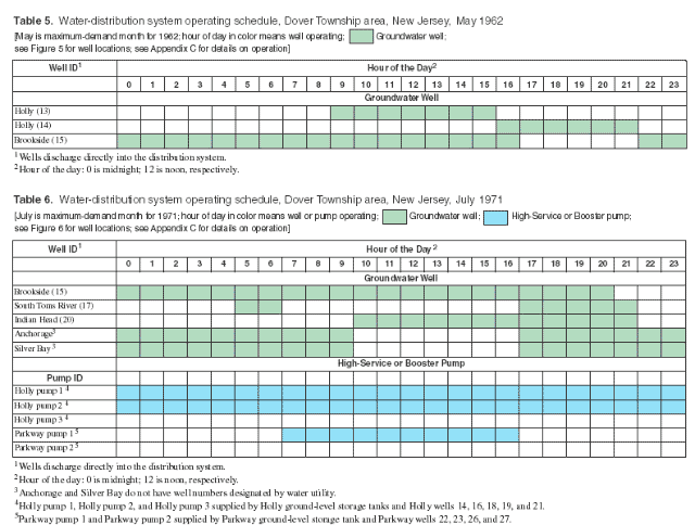
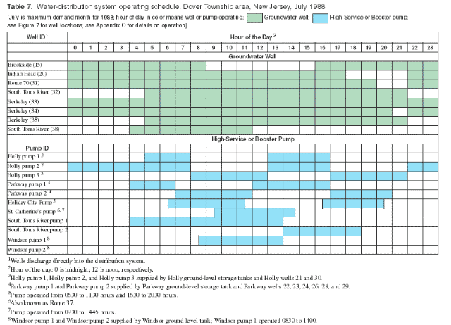
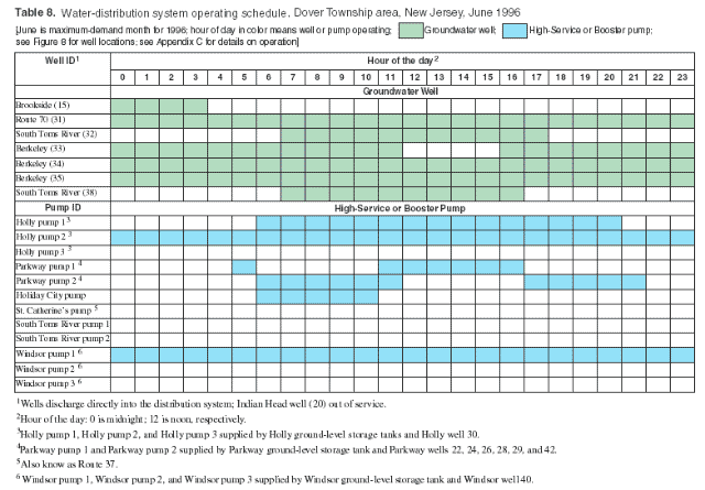
High-Service and Booster Pumps
Data in Tables 6 through 8, and Tables in Appendix C and D, show the operating schedules of high-service and booster pumps. The specific date that high-service and booster pumps were first introduced into the water-distribution system is unknown and could not be verified by the current operators of the water utility. However, information found in the annual reports of the Board of Public Utilities, State of New Jersey (1962–1996) indicate that Holly pumps 1, 2, and 3 were first used sometime during 1968. A listing of all high-service and booster pumps supplying the water-distribution system during the historical period is provided in Table 9. High-service and booster pump discharge data reported by the water utility are limited. In addition, with the exception of Windsor pumps 1, 2, and 3, significant differences occurred between the estimated discharge reported by the water utility and the rated pump capacity values reported in the annual reports of the Board of Public Utilities, State of New Jersey (1962–1996). To account and reconcile these inconsistencies, the generalized "peak day" (summer) and "non-peak day" (fall) operating notes obtained from the water utility were used as initial estimates for determining the operating schedules of the high-service and booster pumps.
The pump discharge information obtained from the water utility is listed in Table 9 in the shaded areas (Richard Ottens, Jr., Production Manager, United Water Toms River, Inc., written communication, 1998). Based on this information (Table 9) and simulation, operating schedules for the high-service and booster pumps shown in Tables 6 through 8, and in tables of Appendices C and D, were developed to simulate the operation of the historical water-distribution system. Additional discussion of the simulation of high-service and booster pump discharge to the water-distribution system using EPANET 2 is provided in the "Methods of Analysis and Approaches to Simulation" section of this report.
Table 9. High-service and booster pump data, Dover Township area, New Jersey, 1962-96
[—, pump not installed, no rated capacity or estimated discharge data available; Estimated discharge data from Richard Ottens, Jr., Production Manager, United Water Toms River, Inc., 1998; values represent typical peak-day (summer) or non-peak day (fall)]
Year |
Pump Identification1 and Rated Capacity or Estimated Discharge, in gallons per minute |
|||||||||||
|---|---|---|---|---|---|---|---|---|---|---|---|---|
|
Holly Pump 1 |
Holly Pump 2 |
Holly Pump 3 |
Parkway Pump 1 |
Parkway Pump 2 |
Holiday City Pump |
St. Catherine's (Route 37) Pump |
South Toms River Pump 1 |
South Toms River Pump 2 |
Windsor Pump 1 |
Windsor Pump 2 |
Windsor Pump 3 |
1962 |
— |
— |
— |
— |
— |
— |
— |
— |
— |
— |
— |
— |
1963 |
— |
— |
— |
— |
— |
— |
— |
— |
— |
— |
— |
— |
1964 |
— |
— |
— |
— |
— |
— |
— |
— |
— |
— |
— |
— |
1965 |
— |
— |
— |
— |
— |
— |
— |
— |
— |
— |
— |
— |
|
||||||||||||
1966 |
— |
— |
— |
— |
— |
— |
— |
— |
— |
— |
— |
— |
1967 |
— |
— |
— |
— |
— |
— |
— |
— |
— |
— |
— |
— |
1968 |
800 |
1,500 |
3,200 |
— |
— |
— |
— |
— |
— |
— |
— |
— |
1969 |
800 |
1,500 |
3,200 |
— |
— |
— |
— |
— |
— |
— |
— |
— |
1970 |
800 |
1,500 |
3,200 |
— |
— |
— |
— |
— |
— |
— |
— |
— |
|
||||||||||||
1971 |
800 |
1,500 |
3,200 |
5,500 |
2,400 |
— |
— |
— |
— |
— |
— |
— |
1972 |
800 |
1,500 |
3,200 |
5,500 |
2,400 |
— |
— |
— |
— |
— |
— |
— |
1973 |
800 |
1,500 |
3,200 |
5,500 |
2,400 |
— |
— |
— |
— |
— |
— |
— |
1974 |
800 |
1,500 |
3,200 |
5,500 |
2,400 |
— |
— |
— |
— |
— |
— |
— |
1975 |
800 |
1,500 |
3,200 |
5,500 |
2,400 |
1,400 |
— |
— |
— |
— |
— |
— |
|
||||||||||||
1976 |
800 |
1,500 |
3,200 |
5,500 |
2,400 |
1,400 |
— |
— |
— |
— |
— |
— |
1977 |
800 |
1,500 |
3,200 |
5,500 |
2,400 |
1,400 |
— |
— |
— |
— |
— |
— |
1978 |
800 |
1,500 |
3,200 |
3,000 |
4,800 |
500 |
500 |
— |
— |
— |
— |
— |
1979 |
800 |
1,500 |
3,200 |
3,000 |
4,800 |
500 |
500 |
— |
— |
— |
— |
— |
1980 |
800 |
1,500 |
3,200 |
5,500 |
2,400 |
1,400 |
1,400 |
500 |
500 |
— |
— |
— |
|
||||||||||||
1981 |
800 |
1,500 |
3,200 |
3,000 |
4,800 |
500 |
500 |
500 |
5000 |
— |
— |
— |
1982 |
800 |
1,500 |
3,200 |
5,500 |
4,800 |
500 |
500 |
500 |
500 |
1,000 |
1,000 |
— |
1983 |
800 |
1,500 |
3,200 |
5,500 |
2,400 |
1,400 |
1,400 |
500 |
500 |
1,000 |
1,000 |
— |
1984 |
800 |
1,500 |
3,200 |
5,500 |
2,400 |
1,400 |
1,400 |
500 |
500 |
1,000 |
1,000 |
— |
1985 |
800 |
1,500 |
3,200 |
5,500 |
2,400 |
1,400 |
1,400 |
500 |
500 |
1,000 |
1,000 |
— |
|
||||||||||||
1986 |
800 |
1,500 |
3,200 |
3,000 |
4,000 |
500 |
500 |
500 |
500 |
1,000 |
1,000 |
— |
1987 |
800 |
1,500 |
3,200 |
3,000 |
4,000 |
500 |
500 |
500 |
500 |
1,000 |
1,000 |
— |
1988 |
800 |
1,500 |
3,200 |
3,000 |
4,000 |
500 |
500 |
500 |
500 |
1,000 |
1,000 |
— |
1989 |
800 |
1,500 |
3,600 |
3,000 |
4,000 |
500 |
1,400 |
500 |
500 |
1,000 |
1,000 |
— |
1990 |
800 |
1,500 |
3,200 |
5,500 |
4,000 |
800 |
650 |
500 |
500 |
1,000 |
1,000 |
1,000 |
|
||||||||||||
1991 |
800 |
1,500 |
3,200 |
2,400 |
5,500 |
1,400 |
650 |
500 |
500 |
1,000 |
1,000 |
1,000 |
1992 |
800 |
1,500 |
3,200 |
2,400 |
5,500 |
1,400 |
650 |
500 |
500 |
1,000 |
1,000 |
1,000 |
1993 |
800 |
1,500 |
3,200 |
2,400 |
5,500 |
800 |
800 |
500 |
500 |
1,000 |
1,000 |
1,000 |
1994 |
800 |
1,500 |
3,200 |
3,200 |
4,800 |
800 |
800 |
500 |
500 |
1,000 |
1,000 |
1,000 |
1995 |
800 |
1,500 |
3,200 |
3,200 |
5,500 |
1,400 |
650 |
500 |
500 |
1,000 |
1,000 |
1,000 |
|
||||||||||||
1996 |
800 |
1,500 |
3,200 |
3,200 |
5,500 |
1,400 |
650 |
500 |
500 |
1,000 |
1,000 |
1,000 |
|
1Pump Identification—High-service pumps: Holly pump 1, Holly pump 2, and Holly pump 3; Parkway pump 1 and Parkway pump 2; Windsor pump 1, Windsor pump 2, and Windsor pump 3. Booster pumps: Holiday City; St. Catherine’s (Route 37); South Toms River pump 1, and South Toms River pump 2. |
||||||||||||
STORAGE-TANK AND WATER-LEVEL DATA
Storage-tank data required for input into EPANET 2 are tank capacities in the form of tank diameter and the minimum and maximum allowable water level. For the historical reconstruction analysis, all storage tanks were assumed of cylindrical geometry. All relevant data on storage tanks in use by the water-distribution system during the historical period of 1962–96 are listed in Table 10. With the exception of the Horner Street tank and standpipe, which were taken out of service in June 1963 (Table 10 and Figure 18; see Plate 3 for location), all storage tanks operating in the present-day system were brought on-line during the historical period. As previously discussed, for simulation purposes, hydraulic devices such as storage tanks were brought into service on June 1 of the specified year in order to meet demand during the peak (summer) season.
The storage capacity of the historical water-distribution system, shown graphically in Figure 10, grew from 0.3 Mgal in 1963 (after removing the Horner Street tank and standpipe from service), to 7.35 Mgal in 1992 with the addition of the North Dover elevated storage tank (see Figure 8 or Plate 33 for location). The capacity of the system at the end of the historical analysis period (1996) and for the present-day system (1998) remains at 7.35 Mgal. As indicated in Table 10, the minimum allowable water level in the tanks (for the purposes of simulating historical conditions) was set at the bottom elevation of the tank plus 3 feet, and the maximum allowable water level was set at the elevation of the top of the tank. This method of storage tank operation is in agreement with the "Master Operating Criteria" (Table 4) previously discussed. A graphical representation of the temporal distribution of storage capacity for the distribution system during the historical period (1962–96) is presented in Figure 18.
Table 10. Storage-tank characterization data used for historical reconstruction analysis, Dover Township area, New Jersey, 1962-96
[Data from annual reports of the Board of Public Utilities, State of New Jersey (1962-96), unless otherwise noted]
Storage Tank Identification |
Type |
Diameter (feet) |
Height1 (feet) |
Volume (million gallons) |
Elevation of Tank Bottom (feet) |
Minimum Water-Level2 (feet) |
Maximum Water-Level (feet) |
Service Year |
|---|---|---|---|---|---|---|---|---|
Horner Street |
Elevated |
20 |
25 |
0.06 |
80 |
3 |
25 |
31898 |
Horner Street |
Standpipe |
25 |
105 |
0.39 |
32 |
3 |
105 |
31926 |
South Toms River |
Elevated |
43.3 |
28 |
0.30 |
166.0 |
3 |
28 |
1963 |
Indian Hill |
Elevated |
50 |
40 |
0.50 |
160.0 |
3 |
40 |
1967 |
Holly 1 |
Ground-level |
88 |
10 |
0.525 |
6.52 |
3 |
10 |
1968 |
Holly 2 |
Ground-level |
88 |
10 |
0.525 |
6.52 |
3 |
10 |
1968 |
Parkway |
Ground-level |
85 |
24 |
1.0 |
10.43 |
3 |
24 |
1971 |
Holiday City |
Ground-level |
82.5 |
24 |
1.0 |
87.12 |
3 |
24 |
1975 |
St. Catherine’s (Route 37) |
Ground-level |
66 |
40 |
1.0 |
42.93 |
3 |
40 |
1978 |
Windsor |
Ground-level |
103 |
24 |
1.5 |
9.84 |
3 |
24 |
1982 |
North Dover |
Elevated |
65 |
51 |
1.0 |
170.0 |
3 |
51 |
1992 |
|
1Data from control room notes taken by ATSDR and NJDHSS staff, March 1998, except for Horner Street elevated-storage tank and standpipe. |
||||||||
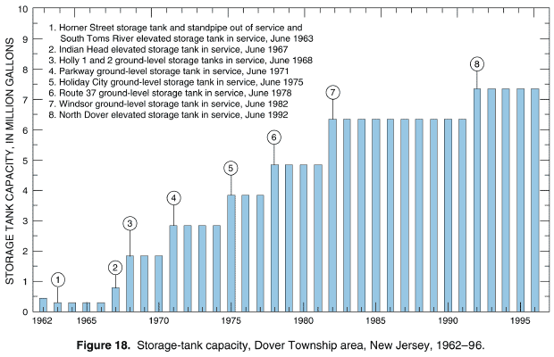
In summary, the six specific data types and other information that were used to conduct the historical reconstruction analysis are described in detail along with appropriate limitations and qualifications. Table 11 summarizes the location of the specific data types and other information in this report or in Maslia et al. (2000a) to assist the reader in locating the data. Specifically, the required data types are: (1) pipeline or network configurations for the historical period (1962–96), (2) potable water production data including information on the location, capacity, and time of operation of the groundwater wells producing the water, (3) estimates of historical consumption and the spatial distribution of point-demand values at pipeline nodes, (4) booster pump-characteristic curve data, (5) system operations information such as schedules that describe the on-and-off cycling of wells and high-service and booster pumps, and (6) data describing the capacity and operational extremes of storage-tanks.
Table 11. Summary of specific data types and other information used to conduct the historical reconstruction analyis, Dover Township area, New Jersey
Specific Data Type |
Location |
|---|---|
Network pipeline data |
Plates 3–37; Figures 5–10; Appendix A |
Groundwater well identification, location, and production data |
Figures 11–14; Appendix B |
Consumption data for 1998 |
Maslia et al. (2000a, Plate 7) |
High-Service and Booster-pump data and characteristic curves |
Maslia et al. (2000a, Table 9 and Appendix F) |
System operation notes for selected years of 1962, 1965, 1971, 1978, 1988, 1995, and 1996 |
Appendix C |
Storage-tank characterization data |
Table 10 |
Other Information |
Location |
|---|---|
"Mastering Operating Criteria": for system operations |
Table 4 |
Graphical presentation of operating schedules for minimum-, maximum-, and average-demand months for selected years 1962, 1965, 1971, 1978, 1988, 1995, and 1996 |
Appendix D |
High-service and booster pump rated capacity and estimated-discharge data |
Table 9 |
For simulation purposes, the ideal or desired condition is to obtain all required data by direct measurement or observation. In reality, however, necessary data are not routinely available by direct measurement or observation and must be synthesized using generally accepted engineering analyses and methods. Issues of data sources and the methods used to obtain data that cannot be directly measured reflect, ultimately, on the credibility of simulation results. To address these issues for the historical reconstruction analysis, the methods for obtaining the necessary data were grouped into three categories (Table 12):
Of the six specific types of information required for the historical reconstruction analysis previously described, the network pipeline, groundwater well-location, groundwater well-production, and storage-tank data were obtained by direct measurement or observation (Table 12). These data were available throughout the entire historical period and could be assessed for quality and verified by independent means such as state reports or field observations. For example, groundwater well-production data were available for every well for every month of the historical period (Appendix B) and these data were measured by the water utility using in-line flow-metering devices at groundwater wells (George J. Flegal, Manager, United Water Toms River, Inc., oral communication, August 28, 2001).
Data for historical consumption and the spatial distribution to pipeline nodes consisted of two components—monthly volumes (quantity) and spatial distribution (location). The monthly volumes were obtained by using the quantitative estimation method previously described (see section on Estimation of Historical Consumption). Data were available from metered billing records for October 1997 through April 1998 and verified through the calibration process described in Maslia et al. (2000a,b); the magnitude of monthly historical production was known based on measured flow data. Using these data, estimates of historical consumption were quantified by imposing the requirement that total consumption must equal total production.
Direct measurement or quantitative estimates of the spatial distribution of historical consumption were not available for the Dover Township area. Therefore, qualitative description methods were used to estimate historical data values. In doing so, estimates of the spatial distribution of historical consumption (point-demand values) were based on two assumptions: (1) historical water-use patterns were similar to the present-day (1998) patterns which are known from available metered billing records (Table 12); and (2) water-use patterns could be inferred from land-use classification using historical land-use classification as a surrogate indicator (see section on "Distribution of Historical Consumption"). To assess the validity of this approach, historical land-use classification and zoning maps for Dover Township were used in conjunction with pipeline network maps for 1962, 1967, 1978, 1990, and 1996. Using information obtained from the land-use classification and pipeline network maps, geospatial (Plates 46–51) and comparative analyses (Table 3) were conducted. Results of these analyses indicated that the distribution of land-use classification in Dover Township was relatively static and changed little during the historical period. These analyses substantially validated the qualitative description method used to estimate the spatial distribution of historical demand-point values.
The high-service and booster pump-characteristic data used during the simulation of historical network operations were derived using information obtained from the water utility (Flegal 1997). This information consisted of head values and corresponding pump flow values which were refined during the model calibration process (Maslia et al. 2000a,b). Consequently, these methods and the resulting pump-characteristic data are characterized as a "Quantitative estimate" (Table 12).
Table 12. Data characterization, availability, and method of obtaining data for historical reconstruction analysis.
Data Type |
Time Frame of Availability |
Source |
Method of Obtaining Data1 |
Notes |
||
|---|---|---|---|---|---|---|
|
Direct Measurement or Observation |
Quantitative Estimate |
Qualitative Description |
|
||
Pipeline location and geometry |
1962–1996 |
Water utility database2 |
X |
In-service date assigned to be January 1 of in-service year |
||
Groundwater well location |
1962–1996 |
Water utility database2 |
X |
In-service date assigned to be June 1 of in-service year |
||
Groundwater well production |
1962–1996 |
Water utility database2, |
X |
Water-utility data, 1962–1996, NJDHSS data, 1962–1979; data from in-line flow meters5, hourly values available for 1996; prior to 1996, monthly values available; average daily operation estimated from monthly data and well capacity |
||
Storage tank geometry, capacity, and location |
1962–1996 |
Water utility database2, |
X |
In-service date assigned to be June 1 of in-service year |
||
Estimation of consumption (demand) |
October 1997–April 1998 |
Water utility billing records, |
X |
Prior to October 1997, data not available to investigators; quantitative estimate based on assumption that demand must equal production |
||
Spatial distribution of consumption (demand) |
October 1997–April 1998 |
Water utility billing records, |
X |
Prior to October 1997, data not available to investigators; estimates based on qualitative assessment of land-use and geospatial analysis. |
||
Pump-characteristic curves |
1998 |
Water utility data2, |
X |
|
None |
|
System operations, 1962–1977 |
None |
"Master Operating Criteria," |
X |
Daily hours of operation for wells from production data |
||
System operations, 1978–1987 |
Typical peak day (summer) and non-peak day (fall) for selected years |
Water utility operational notes7, |
X |
X |
High-service and booster pump discharge estimated from water utility notes |
|
System operations, 1988–1996 |
Typical peak day (summer) and non-peak day (fall) for selected years; all of 1996; and March and August 1998 |
Water utility operational notes7, |
X |
X |
X |
High-service and booster pump discharge estimated from water utility notes; hourly operations data for 1996 |
|
1 Direct measurement or observation—measured or observed data available for some or throughout historical period; data verifiable by independent means; |
||||||
The historical system-operation data were obtained using each of the three methods of obtaining data described previously. These methods apply depending on a specific period of time. For the early historical period (1962–77), investigators relied on hydraulic engineering principles and the "Master Operating Criteria" (Table 4). Because data describing specific operational practices were not available, operating schedules developed for these early historical networks (for example, Tables 5 and 6) were based on qualitative descriptions of system operations and are characterized thusly in Table 12.
For the period 1977–87, system-operation data were derived using hydraulic engineering principles, the "Master Operating Criteria," and from information provided by the water utility. The water-utility information consisted of descriptions of the general operation of the water-distribution system for a typical "peak" day (summer) and a "non-peak" (fall) day. For some of the years, the water utility also provided estimates of discharge to the distribution system from the high-service and booster pumps, such as the data listed in Table 9 (Richard Ottens, Jr., Production Manager, United Water Toms River, Inc., written communication, 1998). Accordingly, system-operations data for the period 1977–87 are characterized as both a "Quantitative estimate" and a "Qualitative description" (Table 12).
System-operation data for the most recent historical systems (1988–96) were obtained from direct measurement or observation, quantitative estimates, and qualitative descriptions of operating schedules. Data sources used to develop these operating schedules (for example, Table 7 and Table 8) included the generalized operating notes from the water utility (Richard Ottens, Jr., Production Manager, United Water Toms River, Inc., written communication, 1998), hourly operations data for 1996 (Flegal 1997), notes taken by ATSDR and NJDHSS staff during field-data collection activities in March and April 1998 (Maslia et al. 2000a), and the observation that the distribution system previously operated in a manner very similar to the present-day system (1998) for which detailed information was available. Given the spectrum of methods used to derive system-operations data for the most recent years of the historical period, data are consequently characterized as a "Direct measurement", a "Quantitative estimate", and a "Qualitative estimate" (Table 12).
OVERVIEW
The application of simulation methods to the historical reconstruction analysis (specifically the application of EPANET 2) using the specific network data for the Dover Township area was accomplished in two steps. First, hydraulic modeling was conducted whereby average network conditions were simulated for every month of the historical period (420 simulations). These simulations were completed under balanced flow conditions that honored hydraulic engineering principles and that conformed to the "Master Operating Criteria" (Table 4). Second, using the results of the monthly network hydraulic simulations, water-quality simulations (source-trace analysis) were conducted for each water source (point of entry) of the network in order to determine the monthly proportionate contribution of source water at all locations in the Dover Township area serviced by the water-distribution system.
Routinely, simulation of water-distribution systems, similar to the historical water-distribution system that serviced the Dover Township area, would require detailed descriptions of system operations, such as the on-and-off scheduling of high-service and booster pumps and groundwater wells for the entire period of simulation. In order to simplify these rigorous data requirements, a surrogate or alternative method was devised. Balanced flow conditions were maintained, and the measured volumes of monthly water production were used while avoiding the need for detailed system operations data, which were not available for most of the historical period. This surrogate method is described in detail in the following sections.
With respect to the scheduling of groundwater well operations, EPANET 2 utilizes "pattern factors" which correspond to the hourly operations of supply wells12. These pattern factors along with the operational extremes of storage tank water levels were manually adjusted during each of the 420 monthly network simulations to achieve balanced flow conditions. This approach to simulation is designated in this report as the "manual adjustment process." All simulation results presented in the "Historical Reconstruction Analysis" section of this report were obtained using the "manual adjustment process."
A second simulation approach was also utilized to achieve balanced flow conditions for each of the 420 monthly networks of the historical period. This approach to simulation is designated the "genetic algorithm" or "GA optimization" approach and is an automated objective simulation technique. The GA simulations utilized the balanced flow conditions obtained by the manual adjustment process as starting conditions. Genetic algorithm techniques were utilized to simulate alternative and possibly optimal water-distribution system operations and to assess the effects of variations in system operations on the results of the proportionate contribution simulations. Results achieved using the GA optimization approach are presented in the "Sensitivity Analysis" section of this report.
HYDRAULIC MODELING
Simulation of water-distribution system hydraulics can be conducted by solving mathematical equations that characterize the physics of water movement through the pipeline network of the water-distribution system. Details of the mathematical formulation and solution technique can be found in numerous references including Bhave (1991), Lansey and Mays (2000), Todini and Pilati (1987), and the EPANET 2 Users Manual and, therefore, will not be repeated here. Requirements for model input data properties using the EPANET 2 software are also provided in the EPANET 2 Users Manual, and are specifically described for the present-day (1998) water-distribution system serving the Dover Township area in Maslia et al. (2000a p. 31).
Network hydraulic models can be used to analyze systems where demand and operating conditions are either static or are time varying. The former type of model is a "steady-state" model, and the latter is referred to as an "extended period simulation" or EPS model. Data gathered in the Dover Township area during March and August 1998 (Figure 4) clearly show the time-varying characteristics of the diurnal-demand patterns. Additionally, observations by ATSDR and NJDHSS staff of system operations during these field-data collection activities also indicated the time-varying characteristics of system operations (on-and-off cycling of wells and high-service and booster pumps). Therefore, all network simulations representing the historical period were conducted as EPS models. Each simulation was conducted for a representative (or "typical") 24-hour period and corresponded to a single month of the historical period. One-hour hydraulic time steps were used to achieve a balanced flow condition and a successful system operating schedule that met the "Master Operating Criteria" (Table 4). To assure that stationary water-quality dynamics were simulated (i.e., "dynamic equilibrium" was reached), the 24-hour operating schedule, which resulted in a balanced flow system, was extended to simulate a period of approximately 1,200 hours. For this extended simulation, the "Master Operating Criteria" requiring the ending water level to equal the starting water level in storage tanks (Table 4) was of critical importance. If this criterion was violated, then, at the end of 1,200 hours, the storage tanks would either be depleted of water or would overflow, causing an unbalanced flow condition and an unsuccessful system operation. Additional details regarding conducting simulations to achieve stationary water-quality dynamics for the present-day (1998) water-distribution system are provided in Maslia et al. (2000a).
To conduct the historical simulations, model parameter values input to EPANET 2 required variation that reflected the change in the historical data. For example, data documenting the installation year of network pipelines were available on an annual basis (Appendix A and Plates 3–37) and thus, model parameters describing the pipeline network were modified in the EPANET 2 simulations on an annual basis. Data documenting water production were available on a monthly basis (Appendix B) and thus, EPANET 2 model parameters associated with production were varied for each month of the historical period simulations. For other model parameters, such as the on-and-off cycling of wells, data were not available throughout the entire historical period (Table 12). Quantitative estimation and qualitative description methods (previously described in the section on "Data Availability, Quality, Methods, and Sources" and in Table 12) were used to derive values required to conduct the EPANET 2 simulations. A summary of model parameters, data availability, and the time-unit variation required to conduct the historical reconstruction simulations using EPANET 2 is provided in Table 13.
Table 13. Summary of model parameters, data availability, and time-unit variation for historical reconstruction analysis, Dover Township area, New Jersey
Model Parameters |
Data Availability |
Time-Unit Variation for Historical Reconstruction Analysis |
Notes |
|---|---|---|---|
Network pipeline data |
11962-96 |
Annual |
Assumed operational date of January 1 for in-service year |
Hydraulic device in-service date |
1, 21962-96 |
Annual |
Assumed operational date of June 1 for in-service year |
Pipe roughness coefficient |
1998 |
No variation |
Maslia et al. (2000a) |
Pipe diameter values |
1998 |
No variation |
Maslia et al. (2000a) |
Pump-characteristic data |
1998 |
No variation |
Maslia et al. (2000a) |
System production data |
21962–96 |
Monthly |
Appendix B |
Point-demand (node) values |
October 1997–April 1998 |
Monthly |
“Specific Data Requirements" section and Maslia et al. (2000a) |
Pattern factors (system operations)3—1962–77 |
None |
Hourly |
"Data Availability, Quality, Methods, and Sources" section and Table 12 |
Pattern factors (system operations)s3—1977–87 |
4Typical peak day (summer) amd non- peak day (fall) for selected years |
Hourly |
"Data Availability, Quality, Methods, and Sources" section and Table 12 |
Pattern factors (system operations)3—1988–96 |
4, 5Typical peak day (summer) and non-peak day (fall) for selected years; 1996; and March and August 1998 |
Hourly |
"Data Availability, Quality, Methods, and Sources" section, Table 12, and Maslia et al. (2000a) |
Nodal concentration or percent contribution of water from specified source |
5March and April 1996 barium sample collection and transport simulation |
24-hour average |
Simulated, 24-hour average of percent contribution of water to model node from water source point of entry (well or well field) |
|
1Data from Flegal (1997). |
|||
Representation of Wells, Storage Tanks, and High-Service and Booster Pumps
As noted previously, a surrogate method was used to simulate historical operations of groundwater wells and storage tanks linked to high-service and booster pumps. For the Holly, Parkway, and Windsor treatment plants13 (Figure 3 or Plate 2), the actual network consists of a groundwater well (or wells) pumping water and discharging the water into a storage tank. Then high-service or booster pumps discharge water from the storage tank into the distribution system based upon some predetermined operating schedule and demand requirements.14 This physical or "real-world" representation is shown in Figure 19A and was the method used to represent the distribution of water during simulation of the present-day system (Maslia et al. 2000a). This method is referred to as the "Well-Storage Tank-Pump" or WSTP simulation method and the corresponding distribution system is referred to as the WSTP system. Using this method (Figure 19A) to calibrate the model to present-day conditions required the following information:
Because data describing this information were available for the present-day system, simulation of the 1998 water-distribution system (Maslia et al. 2000a) was accomplished by using the WSTP simulation method.
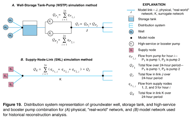
Hourly operations data for the historical water-distribution systems are limited and, for most of the systems, such data are not available (Tables 12 and 13). Additionally, the model parameter that is of interest to both ATSDR and NJDHSS is the proportionate contribution of water from wells and well fields to locations throughout the historical pipeline networks. Thus, the distribution of water delivered to the pipeline locations was the item of interest rather than the specific operation of the WSTP combination which delivered the water. In order to simplify the simulation of the WSTP combination and, thus, reduce data requirements for simulation, a method of idealizing the WSTP combination was developed—designated the "Supply-Node-Link" or SNL simulation method. The SNL method eliminated the need for including the storage tank and high-service and booster pump combinations in the historical simulations. The corresponding water-distribution system is referred to as the SNL system. The Holly, Parkway, and Windsor Avenue treatment plants were represented in historical water-distribution system simulations using the SNL method.
To replace the WSTP method with the SNL method using EPANET 2, the WSTP system was idealized as shown in Figure 19B. Ideally, if measured hourly data for the high-service or booster pumps were available for the historical water-distribution systems, the total flow in surrogate link K over a 24-hour period (Figure 19B) would be equal to the total flow through link J over a 24-hour period from high-service or booster pumps P1 and P2 (Figure 19A)15. Accordingly, flow discharged to the distribution system by supply nodes S1, S2, and S3 (Figure 19B) to meet demand should be equal to the flow that would have been supplied by pumps P1 and P2 shown in Figure 19A.
As previously discussed, groundwater-well production data were based on measurements using in-line flow meters at each well and were available for every month of the historical period (Appendix B and Table 13). These data are considered to be highly reliable. Supply from high-service and booster pumps, on the other hand, was estimated from notes provided by the water utility. These data were not available for most of the historical period (Table 9), and for the most part, were not obtained by direct measurement (Table 12). Accordingly, measured groundwater well production data were used as surrogate indicators of supply to the distribution system at sites where supply wells and storage tanks were linked to high-service and booster pumps, and the less reliable high-service and booster pump supply and operational data were used as guidelines.
Referring to the schematic of the WSTP or "real-world" simulation method shown in Figure 19A, production wells W1, W2, and W3 are shown linked to a storage tank which, in turn, is connected to the distribution system through high-service or booster pumps P1 and P2. The production data listed in Table 14 for example wells W1, W2, and W3 are for an arbitrary month of 31 days. The average daily operation for each well was computed using Equation (1). Note that the total monthly production for the distribution system was 41,217,000 gal. Continuing further with this example, using operational notes provided by a hypothetical water utility, supply volumes were computed for high-service or booster pumps P1 and P2, and these data also are listed in Table 14. The assumption was made that pumps P1 and P2 were operated in the same manner over the course of the month. Note that groundwater well production for the month (41,217,000 gal) exceeds high-service and booster pump production (39,060,000 gal) by 2,157,000 gal.
Table 14. Production and supply data for a hypothetical distribution system
[—, not applicable]
Well ID |
Rated Capacity |
Monthly Production |
Average Daily Operation1 |
|---|---|---|---|
|
|||
Groundwater Wells |
|||
W1 |
700 |
13,020,000 |
10.0 |
W2 |
800 |
14,061,000 |
9.45 |
W3 |
1,000 |
14,136,000 |
7.6 |
All wells |
— |
41,217,000 |
— |
Pump ID |
Rated Capacity |
Hours of Operation |
Monthly Supply2 |
|---|---|---|---|
|
|||
High-Service or Booster Pumps |
|||
P1 |
1,000 |
0600–2000 (14) |
26,040,000 |
P2 |
500 |
0600–2000 (14) |
13,020,000 |
All pump |
— |
— |
39,060,000 |
|
1Average daily operation in hours computed by assuming a 31-day month and using Equation (1); see section on "Specific Data Needs." |
|||
Referring to the schematic of the surrogate SNL simulation method (Figure 19B), the wells, storage tank, and high-service and booster pumps are eliminated and replaced by "supply nodes" S1, S2, and S3. The number of hours that the combination of supply nodes S1, S2, and S3 must operate in the model just to meet demand supplied by pumps P1 and P2 (39,060,000 gal in this example) had to be determined. Thus, consider the following equation:
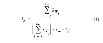
where:
TS = time of operation for supply nodes, in hours per day;
QWi = monthly production from the ith well, in gallons per month;
CPj = rated capacity of the jth high-service or booster pump, in gallons per minute;
nw = the number of groundwater wells producing water for the month;
np = the number of high-service or booster pumps supplying the distribution system for the month;
Tm = number of minutes per hour (60); and
Td = number of days per month (for this example, 31).
The groundwater-well production and high-service and booster-pump capacity values from Table 14 are now substituted into Equation (11). Therefore, the average number of hours per day the supply nodes (S1, S2, and S3) were operated to meet demand can be computed as:
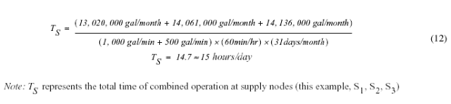
Having determined the total number of hours per day of supply node operation, the volume of water supplied by the SNL system to the water-distribution system from individual supply nodes (S1, S2, and S3) must next be computed. Although alternative methods of computing these volumes are possible, the method chosen for this investigation utilizes the pattern factor variation capabilities of EPANET 2.
As an initial estimate, each supply node in the SNL system was assumed to have operated for the same number of hours and to have supplied the same volume of water assigned to the corresponding groundwater well in the WSTP system. Thus, using the values listed in Table 14 for the groundwater wells W1, W2, and W3 as initial estimates:
However, according to Equation (12), the combined daily time of operation (TS) for supply nodes S1, S2, and S3 was 15 hours. Therefore, in the SNL method, for the supply nodes to supply the equivalent volume of water over a 24-hour period per the operation of wells W1, W2, and W3 in the WSTP method, the hourly operation of the individual supply nodes have to be modified. In EPANET 2, this was accomplished by using a pattern factor (the default value in EPANET 2 being 1.0). The modified pattern factors for each supply node of the SNL system—reflecting a combined total of 15 hours of operation—were computed according to Equation (13):
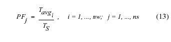
where:
PFj = Pattern factor for supply node j (dimensionless),
Tavgi = average time well i operated, in hours per day (Table 14),
TS = total time of operation for supply nodes, in hours per day (Equation (11)),
nw = number of wells operating (Figure 19A), and
ns = number of supply nodes (Figure 19B).
Subsitituting in values for Tavgi representing W1, W2, and W3 from Table 14, and the value for TS of 15 hours per day computed using Equation (11), the following pattern factors were computed for supply nodes S1, S2, and S3, respectively:
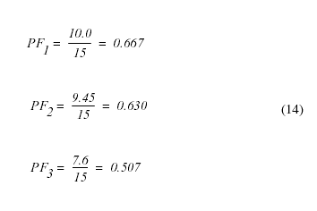
Therefore, using the SNL method to simulate the equivalent volume of water contributed to the distribution system over a 24-hour period by the WSTP method, the supply nodes were operated according to the following schedule in EPANET 2:
The operational schedule and water supply information for the supply nodes using the SNL method for the hypothetical network in Figure 19 are summarized in Table 15.
Table 15. Water supply for a hypothetical distribution system computed using the Supply-Node-Link (SNL) method
[—, not applicable]
Supply Node Identification |
Rated Capacity |
EPANET 2 |
Monthly Supply3 |
|
|---|---|---|---|---|
Pattern Factor1 |
Hours of Operation2 |
|||
S1 |
700 |
0.667 |
0600–2100 (15) |
13,026,510 |
S2 |
800 |
0.630 |
0600–2100 (15) |
14,061,600 |
S3 |
1,000 |
0.507 |
0600–2100 (15) |
14,145,300 |
All supply nodes |
— |
— |
— |
41,233,410 |
|
1Computed using Equation (13). |
||||
Over the entire 31-day month (for this example), the total combined volume from the three supply nodes is listed in Table 15 and also can be computed according to the following equation:
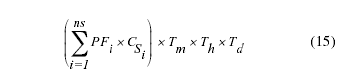
where:
CSi = capacity for supply node i, in gallons per minute.
The total monthly supply derived from the supply nodes using the SNL method was computed as 41,233,410 gal which is nearly identical to the total production of 41,217,600 gal obtained from the production data for the hypothetical distribution system (Table 14). Thus, in summary, a mechanism for representing the physical WSTP system (Figure 19A) with the idealized SNL system (Figure 19B) was developed that: (1) honors the measured groundwater-well production data, (2) approximates the operational schedule of the high-service and booster pumps, and (3) eliminates the need to include storage tanks and high-service or booster pumps linked to groundwater wells in the EPANET 2 model for historical reconstruction simulations.
To demonstrate that the idealized SNL simulation method supplies the distribution system with an equivalent amount of water when compared to the "real-world" WSTP simulation method, both simulation methods were applied to the present-day (1998) water-distribution system (Figure 3, Plate 2) for conditions existing in August 1998. As previously discussed, the WSTP simulation method requires: (1) known operating schedules for groundwater well and high-service and booster pump on-and-off cycling, (2) observed storage tank water-level variations, and (3) realistic high-service and booster pump-characteristic curves. Operating schedule data for wells and high-service and booster pumps and storage tank water-level variation data were collected in August 1998 as part of the field-data collection activities used to characterize the present-day water-distribution system (Maslia et al. 2000a). High-service and booster pump-characteristic curve data were obtained from the water utility (Flegal 1997) and refined during the calibration process These data and simulation results using the WSTP simulation method for the Holly and Parkway treatment plants were previously reported in Maslia et al. (2000a, Appendix N). Because measured data and results using the WSTP simulation method were available for a 48-hour period (August 14–15, 1998), an EPANET 2 simulation using the SNL method to represent the Holly and Parkway treatment plants was conducted using a 48-hour simulation time. Measured and simulated high-service pump flows—using the WSTP simulation method—are compared with simulated flows for the SNL method represents of the Holly and Parkway treatment plants in Figure 20. The results obtained using both the WSTP and the SNL methods produce nearly identical simulated flow. Additionally, the hourly pump flows for August 14–15, 1998 representing measured data and simulation results for the WSTP and SNL methods are listed in Table 16. Total simulated supply to the distribution system from the Holly treatment plant over the 48-hour period using the SNL method was 5.62 Mgal, which is nearly identical to the measured supply of 5.63 Mgal (Table 16). For the Parkway treatment plant, simulated flow using the SNL method was 8.53 Mgal which is less than 3% different from the measured flow of 8.32 Mgal. Thus, results obtained using both the WSTP and the SNL methods produce nearly identical simulated flows, thereby confirming the appropriateness of representing the "real-world" WSTP distribution system (Figure 19A) with the surrogate SNL distribution system (Figure 19B).
The application of the SNL method to simulate historical water-distribution system operations is identified in the operational notes listed in Appendix C. For example, in Table C-3, for the maximum-demand month of July 1971, the operational notes state that the Holly ground-level storage tanks are "in service" but "closed in EPANET 2." This wording indicates that the operation of Holly storage tanks was not explicitly accounted for during simulation of the hydraulics of the July 1971 water-distribution system, but rather, was replaced by supply wells of the surrogate SNL method as shown in Figure 19. The operational notes in Table C-3 also state that the Holly supply wells pump directly into the distribution system. The simulated discharge from the surrogate Holly supply wells represent the discharge from the Holly high-service pumps into the distribution system. From the notes in Table C-3, the total discharge from Holly high-service pumps 1 and 2 over a 24-hour period for July 1971 was estimated as 3.376 Mgal. The total flow from the surrogate supply wells representing Holly wells 14, 16, 18, 19, and 21 is also 3.376 Mgal. Thus, the simulated volume of water discharged to the distribution system using the SNL method (supply nodes representing the Holly wells linked to the Holly storage tanks and high-service pumps) was equivalent to the estimated discharge of the Holly high-service pumps. Descriptions of the SNL representation of other facilities in the water-distribution system, namely the Parkway and Windsor treatment plants, can also be found in the operational notes of Appendix C.
Manual Adjustment Process
As described previously, two simulation methods were used to achieve balanced flow conditions that honored hydraulic engineering principles and that conformed to the "Master Operating Criteria" (Table 4)—the manual adjustment process and the GA optimization method. Using the manual adjustment process, investigators manually adjusted and refined certain system physical and operational parameters in order to achieve balanced flow conditions and satisfy system operational requirements described by the "Master Operating Criteria" (Table 4) or described in water-utility operational notes. Model parameters that could have been adjusted during a simulation or calibration process are pipe roughness coefficients, pipe diameters (using nominal versus actual), point (nodal) demands, pump-characteristic curve data, and system operational data such as the on-and-off cycling of wells and high-service and booster pumps. Based on results of initial simulations, the model parameter that most affected water-distribution system pressures and hydraulic gradients was the pattern factor—the system operations parameter which controlled the on-and-off cycling of wells and high-service and booster pumps. The effects on simulation results of modifying other modeling parameters such as pipe roughness coefficient, pipe diameter, point demands, or pump-characteristic curves were minor in comparison. In fact, based on sensitivity analyses conducted using the calibrated model of the present-day (1998) network, the water-distribution system was found to be insensitive to variation in pipe roughness coefficient and diameter (Maslia et al. 2000a, p. 51). Therefore, only pattern factors were adjusted during simulations of the historical water-distribution systems. Pipe roughness coefficients, pipe nominal diameter values, and pump-characteristic curves were not adjusted and were the same as those determined from the model calibration and testing of the present-day water-distribution system (Maslia et al. 2000a). Point demands (nodal values) were varied on a monthly basis using the methods explained previously to derive monthly values (see section on "Estimation and Distribution of Historical Consumption)." A listing of model parameters and time-unit variation used for simulating the historical water-distribution systems is provided in Table 13.
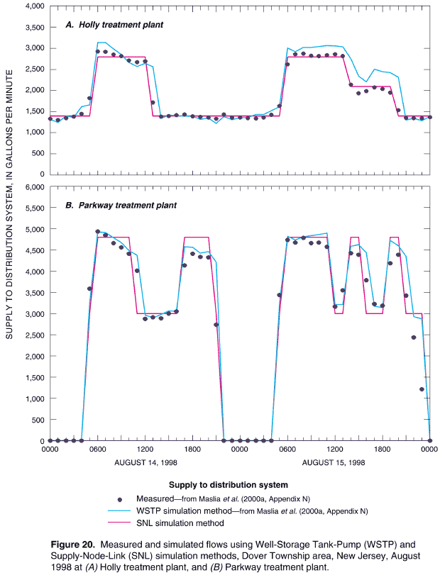
Table 16. Comparison of measured high-service pump flows and the Well-Storage Tank-Pump and Supply-Node-Link simulation methods, Dover Township area, New Jersey, August 1998
[gmp, gallons per minute; WSTP, well-storage tank-pump; SNL, supply-node-link]
Time (hour) |
Measured1 (gpm) |
WSTP Method2 (gpm) |
SNL Method (gpm) |
Time (hour) |
Measured1 (gpm) |
WSTP Method2 (gpm) |
SNL Method (gpm) |
|
|---|---|---|---|---|---|---|---|---|
|
||||||||
Holly Treatment Plant |
||||||||
0:00 |
1,328.21 |
1,317.16 |
1,395.00 |
0:00 |
1,357.41 |
1,351.68 |
1,395.00 |
|
1:00 |
1,305.38 |
1,239.73 |
1,395.00 |
1:00 |
1,342.98 |
1,358.62 |
1,395.00 |
|
2:00 |
1,344.66 |
1,395.69 |
1,395.00 |
2:00 |
1,336.60 |
1,431.48 |
1,395.00 |
|
3:00 |
1,380.91 |
1,359.77 |
1,395.00 |
3:00 |
1,361.77 |
1,432.60 |
1,395.00 |
|
4:00 |
1,445.69 |
1,612.64 |
1,395.00 |
4:00 |
1,425.89 |
1,520.44 |
1,395.00 |
|
5:00 |
1,816.93 |
1,658.27 |
1,395.00 |
5:00 |
1,635.67 |
1,617.56 |
1,395.00 |
|
|
||||||||
6:00 |
2,925.95 |
3,142.01 |
2,800.00 |
6:00 |
2,618.49 |
3,007.71 |
2,800.00 |
|
7:00 |
2,922.60 |
3,137.37 |
2,800.00 |
7:00 |
2,862.51 |
2,918.64 |
2,800.00 |
|
8:00 |
2,853.79 |
2,984.89 |
2,800.00 |
8:00 |
2,876.61 |
3,026.42 |
2,800.00 |
|
9:00 |
2,817.53 |
2,854.32 |
2,800.00 |
9:00 |
2,823.58 |
3,024.38 |
2,800.00 |
|
10:00 |
2,716.84 |
2,662.70 |
2,800.00 |
10:00 |
2,817.20 |
3,045.62 |
2,800.00 |
|
11:00 |
2,669.51 |
2,569.35 |
2,800.00 |
11:00 |
2,837.34 |
3,065.93 |
2,800.00 |
|
|
||||||||
12:00 |
2,694.01 |
2,644.58 |
2,800.00 |
12:00 |
2,859.83 |
3,058.64 |
2,800.00 |
|
13:00 |
1,721.27 |
2,563.82 |
1,395.00 |
13:00 |
2,818.88 |
3,035.15 |
2,800.00 |
|
14:00 |
1,386.28 |
1,341.46 |
1,395.00 |
14:00 |
2,143.53 |
2,750.65 |
2,100.00 |
|
15:00 |
1,397.02 |
1,418.59 |
1,395.00 |
15:00 |
1,937.10 |
2,341.93 |
2,100.00 |
|
16:00 |
1,419.84 |
1,404.73 |
1,395.00 |
16:00 |
1,988.45 |
2,207.80 |
2,100.00 |
|
17:00 |
1,431.59 |
1,398.22 |
1,395.00 |
17:00 |
2,072.03 |
2,507.51 |
2,100.00 |
|
|
||||||||
18:00 |
1,386.61 |
1,388.77 |
1,395.00 |
18:00 |
2,039.14 |
2,449.10 |
2,100.00 |
|
19:00 |
1,378.56 |
1,317.87 |
1,395.00 |
19:00 |
1,949.18 |
2,427.58 |
2,100.00 |
|
20:00 |
1,361.10 |
1,349.64 |
1,395.00 |
20:00 |
1,533.63 |
2,315.77 |
1,395.00 |
|
21:00 |
1,329.22 |
1,220.05 |
1,395.00 |
21:00 |
1,352.71 |
1,300.51 |
1,395.00 |
|
22:00 |
1,432.60 |
1,379.60 |
1,395.00 |
22:00 |
1,344.32 |
1,337.35 |
1,395.00 |
|
23:00 |
1,346.46 |
1,306.80 |
1,395.00 |
23:00 |
1,348.35 |
1,284.74 |
1,395.00 |
|
Total supply to distribution system after 48 hours, in gallons |
5,633,076 |
5,993,871 |
5,619,600 |
|||||
Parkway Treatment Plant |
||||||||
0:00 |
0.00 |
0.00 |
0.00 |
0:00 |
0.00 |
0.00 |
0.00 |
|
1:00 |
0.00 |
0.00 |
0.00 |
1:00 |
0.00 |
0.00 |
0.00 |
|
2:00 |
0.00 |
0.00 |
0.00 |
2:00 |
0.00 |
0.00 |
0.00 |
|
3:00 |
0.00 |
0.00 |
0.00 |
3:00 |
0.00 |
0.00 |
0.00 |
|
4:00 |
0.00 |
0.00 |
0.00 |
4:00 |
0.00 |
0.00 |
0.00 |
|
5:00 |
3,591.00 |
3,256.72 |
3,000.00 |
5:00 |
3,438.25 |
3,235.61 |
3,000.00 |
|
|
||||||||
6:00 |
4,942.25 |
4,920.24 |
4,800.00 |
6:00 |
4,743.25 |
4,826.79 |
4,800.00 |
|
7:00 |
4,847.75 |
4,911.90 |
4,800.00 |
7:00 |
4,679.00 |
4,741.47 |
4,800.00 |
|
8:00 |
4,664.00 |
4,786.99 |
4,800.00 |
8:00 |
4,792.00 |
4,814.87 |
4,800.00 |
|
9:00 |
4,561.00 |
4,671.82 |
4,800.00 |
9:00 |
4,662.50 |
4,843.04 |
4,800.00 |
|
10:00 |
4,416.00 |
4,480.89 |
4,800.00 |
10:00 |
4,679.25 |
4,862.56 |
4,800.00 |
|
11:00 |
4,018.75 |
4,371.08 |
3,000.00 |
11:00 |
4,583.25 |
4,901.19 |
4,800.00 |
|
|
||||||||
12:00 |
2,880.25 |
2,966.48 |
3,000.00 |
12:00 |
3,161.50 |
3,210.21 |
3,000.00 |
|
13:00 |
2,918.25 |
2,895.25 |
3,000.00 |
13:00 |
3,550.00 |
3,210.20 |
3,000.00 |
|
14:00 |
2,893.25 |
2,977.89 |
3,000.00 |
14:00 |
4,422.25 |
4,591.51 |
4,800.00 |
|
15:00 |
3,000.75 |
3,061.75 |
3,000.00 |
15:00 |
4,388.25 |
4,623.69 |
4,800.00 |
|
16:00 |
3,048.00 |
3,053.90 |
3,000.00 |
16:00 |
3,795.50 |
4,442.62 |
3,000.00 |
|
17:00 |
4,142.25 |
4,579.18 |
4,800.00 |
17:00 |
3,222.25 |
3,174.46 |
3,000.00 |
|
|
||||||||
18:00 |
4,418.75 |
4,560.60 |
4,800.00 |
18:00 |
3,185.75 |
3,134.71 |
3,000.00 |
|
19:00 |
4,339.75 |
4,429.51 |
4,800.00 |
19:00 |
4,186.50 |
4,719.67 |
4,800.00 |
|
20:00 |
4,321.00 |
4,458.03 |
4,800.00 |
20:00 |
4,387.75 |
4,596.08 |
4,800.00 |
|
21:00 |
2,741.25 |
4,209.10 |
3,000.00 |
21:00 |
3,426.50 |
4,354.23 |
3,000.00 |
|
22:00 |
0.00 |
0.00 |
0.00 |
22:00 |
2,441.75 |
2,927.97 |
3,000.00 |
|
23:00 |
0.00 |
0.00 |
0.00 |
23:00 |
1,211.50 |
2,872.88 |
3,000.00 |
|
Total supply to distribution system after 48 hours, in gallons |
8,322,075 |
8,803,109 |
8,532,000 |
|||||
|
1Measured data for August 14–15, 1998, from Maslia et al. (2000a, Appendix N). |
||||||||
Genetic Algorithm (GA) Optimization
As shown in Tables 12 and 13, with the exception of the present-day (1998) and the 1996 water-distribution system, hourly-specific information regarding the operation of wells and high-service and booster pumps for the historical networks was not available16. Therefore, developing and investigating alternative operating schedules for the historical water-distribution systems and evaluating the effects of these alternative schedules with respect to results were considered critical parts of the historical reconstruction analysis17. The issues to be resolved were which alternative schedules would represent in a successful way the operation of the historical water-distribution systems and, if multiple alternatives were available, which ones should be chosen for investigation and analyses. Accordingly, the following questions were posed:
To answer these questions and address the issues raised by the external panel (ATSDR 2001e), a technique was required to "search" for and select a set of alternative operating conditions that, when applied, would result in the satisfactory operation of the historical water-distribution systems. Such a technique is the Genetic Algorithm (GA) optimization method. Simply put, a GA method refers to an optimization technique that attempts to find the best solution based on mimicking (in a computational sense) the mechanics of natural selection and natural genetics (Holland 1975, Goldberg 1989; Haupt and Haupt 1998, Walski et al. 2001). A complete description of the concept and application of GA methods is included in Appendix E.
Previously, the GA has been coupled with hydraulic network solvers to select a set of roughness coefficient values to automate the model calibration process (Savic and Walters 1995, 1997, Walters et al. 1998). A GA analysis begins with a trial solution using a set of assumed values for the decision variables. The decision variables are automatically adjusted to create additional trial solutions. Each trial solution is then used for an objective function that evaluates the "fitness" of the solution. Based on the evaluation of the fitness of the solution, the most recent set of decision variables is either (1) directly entered for the next solution ("direct selection"), (2) combined with values from other solutions ("crossover"), or (3) adjusted slightly by use of random changes ("mutated") to obtain a new trial solution. The GA method does not apply this process to just one trial solution, but rather, the approach is based on the consideration of many trials or a set of solutions ("a population") at any one time. The process described above continues for a specified number of solutions ("generations") until the solution cannot be improved very readily (or until some stopping criteria is met). Although this approach does not guarantee an optimal solution, it is usually a very good solution to the objective function. The technique of coupling a GA method with hydraulic network solvers is still in its infancy. However, results have demonstrated the GA method has the ability to greatly assist in the evaluation of complex water-distribution systems.
The GA method was applied to historical water-distribution systems that served the Dover Township area. In order to derive alternative on-and-off cycling patterns (and pattern factors) for every operating well, alternative sets of successful operating conditions were derived for every month of the historical period (January 1962–December 1996). The decision variables for the GA analyses were the hourly schedules of on-and-off cycling of wells and the well-pattern factors. The objective function was constrained by the pressure and storage tank water-level requirements described in the "Master Operating Criteria" (for example, minimum pressure at any pipeline node must be greater than 15 pounds per square inch (psi), maximum pressure at any pipeline node must not exceed 110 psi; see Table 4).
Owing to the complexity of the analysis, a new approach that embeds a GA in a progressive optimality algorithm was developed (Guan and Aral 1999a,b, Aral et al. 2001a,b,c). The resulting algorithm is identified as the Progressive Optimality Genetic Algorithm (POGA), which was applied to obtain solutions for alternative and optimal system-operation patterns for every network of the historical period (420 months). Initial estimates to start the POGA solution were obtained from the on-and off cycling patterns derived from the manual adjustment process, previously described. This guaranteed that the POGA would begin with balanced flow conditions, although because of the robustness of this approach, such a requirement is unnecessary. A complete and detailed description of the POGA methodology and approach (Aral et al. 2001b) is included as part of this report (Appendix E). The reader that is interested in the developmental and computational aspects of the POGA should refer to Appendix E for details. In a subsequent section of the report (see section on "Sensitivity Analysis"), the proportionate contribution results obtained from the GA methodology are described and compared with proportionate contribution results obtained from the manual adjustment process.
WATER-QUALITY MODELING (SOURCE-TRACE ANALYSIS)
The fate of a dissolved constituent flowing through a distribution network over time is tracked by the EPANET 2 dynamic water-quality simulator. To model the water quality of a distribution system, EPANET 2 uses flow information computed from the hydraulic network simulation as input to the water-quality model. The water-quality model uses the computed flows to solve the equation for conservation of mass for a substance within each link. Details of the specific mathematical formulation of the water-quality simulator and the solution technique are provided in the EPANET 2 Users Manual, as are the model input data requirements.
Identifying the source of delivered water in a distribution system is necessary when trying to determine the exposure of water users to chemical or biological constituents. Males et al. (1985) developed a method using simultaneous equations to calculate the spatial distribution of variables such as percentage of flow, concentration, and travel times that could be associated with links and nodes, under steady-flow conditions. Grayman et al. (1988) developed a water-quality model that used flows previously generated by a hydraulic model and a numerical method to route contaminants—conservative and non-conservative—through a distribution system. This type of model has become known as a dynamic water-quality model. EPANET 2 is also a dynamic water-quality model, and has the ability to compute the percentage of water reaching any point in the distribution system over time from a specified location (source) in the network—the "proportionate contribution" of water from a specified source. To estimate the proportionate contribution of water, a source location is assigned a value of 100%. The resulting solution provided by the waterquality simulator in EPANET 2 then becomes the percentage of flow at any location in the distribution-system network (for example, a demand node) contributed by the source location of interest.
For the historical reconstruction analyses, a source-trace analysis was conducted for every month of the historical period. The list of EPANET 2 source-node identifications assigned to points of entry for the source-trace analyses is included in Appendix F (Table F-1 through F-35). These source nodes were assigned a value of 100% in order to estimate the proportionate contribution of water to locations in the historical distribution-system networks. Initial conditions must be "flushed out" of the distribution system before retrieving the proportionate contribution results (Maslia et al. 2000a, p. 55). Accordingly, the monthly historical network models were run for simulation periods of approximately 1,200 hours to reach a state of stationary water-quality dynamics ("dynamic equilibrium") as previously explained. The results of the source-trace analyses reported herein represent the last 24 hours of the 1,200 hours of the simulation period. Hydraulic time steps of 1 hour, and water-quality time steps of 5 minutes were used. For some monthly simulations in the 1980s, the water-quality time steps were reduced to 1 minute. These smaller water-quality time steps were necessary to ensure that the mass balance summed to 100%. Results of the source-trace analyses are presented and discussed in the next section of this report.
Having assembled data required by the EPANET 2 requirements (see section on "Specific Data Needs"), hydraulic and water-quality simulations (source-trace analyses) were conducted for each month of the historical period (January 1962–December 1996). The simulations, used to determine the proportionate contribution of water from the wells and well fields (points of entry) to various locations in the water-distribution system, were conducted for each of the 420 months of the historical period. The manual adjustment process, as previously described (see section on "Methods of Analysis and Approaches to Simulation"), was used to simulate the on-and-off cycle of groundwater wells and to assure that all conditions of the "Master Operating Criteria" were satisfied. Simulation results presented in this section of the report were accomplished using the manual adjustment process.
PROPORTIONATE CONTRIBUTION RESULTS
The percentage of water from a particular well or well field (for example, Brookside well 15 or the Parkway well field) is provided at model nodes (pipeline junctions) throughout the distribution-system network as a result of the proportionate contribution analyses. Results are displayed in a map format showing the areal distribution of the proportionate contribution of water from the well or well field of interest (for example, Holly wells) to any location in the Dover Township area (Figure 21). In Figure 21, simulated proportionate contribution results for all model nodes18 are shown for the maximum-demand month of July 1988, using the Parkway well field as the point of entry (or source point). The simulated proportionate contribution results are divided into six intervals—1% to 10%, 10% to 25%, 25% to 50%, 50% to 75%, 75% to 90%, and 90% to 100%—and a color is assigned to all nodes within each interval. A different map is required for each different well or well field for each specific month and year to completely present the results. Therefore, for each operating well or well field, simulated proportionate contribution results are presented for three selected months—minimum-, maximum-, and average-demand—for seven selected years—1962, 1965, 1971, 1978, 1988, 1995, and 1996. The maps are provided in this report under separate cover as Plates 52 through 153. Table 17 lists the selected months and years for each well or well field for which results are presented in the map format, and lists the map identification numbers in the report (Plates 52–153)19.
Simulated proportionate contribution results can also be viewed in terms of selected pipeline locations. Five geographically distinct pipeline locations were selected from the historical networks to represent the spatial distribution of proportionate contribution results. These locations are identified on Figures 5 through 8, Figure 21, and Plates 52 through 153 as locations A, B, C, D, and E. The model node identification number of each selected pipeline location is listed in Table 18. Using this method of presentation, results are listed in a tabular format for every month of the selected years 1962, 1965, 1971, 1978, 1988, 1995, and 1996 for pipeline locations A, B, C, D, and E. Simulated proportionate contribution results presented in this format are summarized in Appendix G (Tables G-1 through G-7).
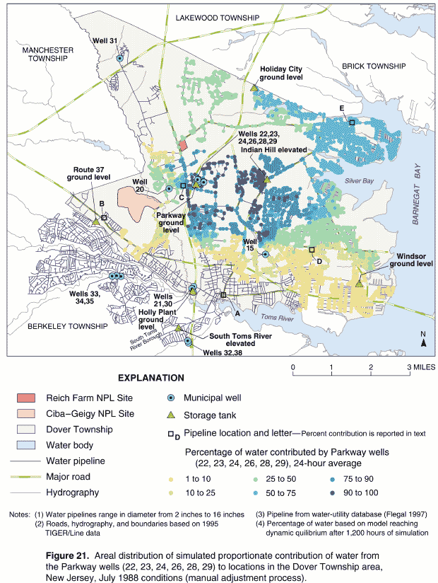
Table 17. Well or well field (point of entry) for which simulated proportionate contribution results are shown on maps, year, month of analysis, and map-identification number, Dover Township area, New Jersey
[— Well or well field not part of ditribution system or not operating during this month; see Plates under separate cover]
Month |
Well or Well Field1 |
|||||||||
|---|---|---|---|---|---|---|---|---|---|---|
|
Holly |
Brookside (15) |
South Toms River |
Indian Head (20) |
Parkway |
Route 70 (31) |
Berkeley |
Windsor (40) |
Anchorage |
Silver Bay |
|
||||||||||
1962 |
||||||||||
February2 |
3Plate 52 |
Plate 53 |
— |
— |
— |
— |
— |
— |
— |
— |
May |
Plate 54 |
Plate 55 |
— |
— |
— |
— |
— |
— |
— |
— |
October |
Plate 56 |
Plate 57 |
— |
— |
— |
— |
— |
— |
— |
— |
1965 |
||||||||||
February |
Plate 58 |
Plate 59 |
— |
— |
— |
— |
— |
— |
— |
— |
June |
Plate 60 |
Plate 61 |
— |
— |
— |
— |
— |
— |
— |
— |
October |
Plate 62 |
Plate 63 |
— |
— |
— |
— |
— |
— |
— |
— |
1971 |
||||||||||
February |
Plate 64 |
Plate 65 |
Plate 66 |
Plate 67 |
— |
— |
— |
— |
Plate 68 |
Plate 69 |
July |
Plate 70 |
Plate 71 |
Plate 72 |
Plate 73 |
Plate 75 |
— |
— |
— |
Plate 74 |
Plate 76 |
October |
Plate 77 |
Plate 78 |
Plate 79 |
Plate 80 |
— |
— |
— |
— |
Plate 81 |
Plate 82 |
1978 |
||||||||||
February |
Plate 83 |
— |
Plate 84 |
Plate 85 |
Plate 86 |
— |
— |
— |
— |
— |
June |
Plate 87 |
Plate 88 |
Plate 89 |
Plate 90 |
Plate 91 |
— |
— |
— |
Plate 92 |
Plate 93 |
October |
Plate 94 |
Plate 95 |
Plate 96 |
Plate 97 |
Plate 98 |
— |
— |
— |
— |
— |
1988 |
||||||||||
February |
Plate 99 |
Plate 100 |
Plate 101 |
— |
Plate 102 |
Plate 103 |
Plate 104 |
— |
— |
— |
July |
Plate 105 |
Plate 106 |
Plate 107 |
Plate 108 |
Plate 109 |
Plate 110 |
Plate 111 |
— |
— |
— |
October |
Plate 112 |
— |
Plate 113 |
Plate 114 |
Plate 115 |
Plate 116 |
Plate 117 |
— |
— |
— |
1995 |
||||||||||
February |
— |
— |
Plate 118 |
Plate 119 |
Plate 120 |
Plate 121 |
Plate 122 |
— |
— |
— |
August |
Plate 123 |
Plate 124 |
Plate 125 |
Plate 126 |
Plate 127 |
Plate 128 |
Plate 129 |
Plate 130 |
— |
— |
October |
Plate 131 |
— |
— |
Plate 132 |
Plate 133 |
Plate 134 |
Plate 135 |
Plate 136 |
— |
— |
1996 |
||||||||||
February |
— |
— |
Plate 137 |
Plate 138 |
Plate 139 |
Plate 140 |
Plate 141 |
— |
— |
— |
June |
Plate 142 |
Plate 143 |
Plate 144 |
— |
Plate 145 |
Plate 146 |
Plate 147 |
Plate 148 |
— |
— |
October |
Plate 149 |
— |
Plate 150 |
— |
Plate 151 |
Plate 152 |
Plate 153 |
— |
— |
— |
|
1Well numbers in parentheses are well-identification numbers; no number indicates a well field containing multiple wells; Anchorage and Silver Bay wells do not have well numbers assigned by water utility. |
||||||||||
Table 18. Pipeline location letters and corresponding model node numbers for which simulated proportionate contribution results are discussed in text and shown in figures and on plates
[see Figure 21 or Plates 52–153 for location]
Pipeline Location Identification Letter |
Model Node Identification Number |
Descriptive Location |
|---|---|---|
A |
2997 |
South-central Dover Township |
B |
3730 |
Southwestern Dover Township |
C |
4606 |
West-central Dover Township |
D |
7148 |
Southeastern Dover Township |
E |
10117 |
Northeastern Dover Township |
The percentage of water contributed by every well and well field for any given time, also can be viewed at selected pipeline using a "stacked" column graph. This method of presentation uses one column to represent each of the five selected pipeline locations—A through E. The contribution of water, in percent, from each operating well or well field for the time of interest is "stacked" one on top of the other within each column. Figure 22 is an example of simulation results using this method of presentation for the maximum-demand month of July 1988. Note, the pipeline locations A–E referenced in this column graph are shown in Figure 21. For example, simulated proportionate contribution results shown in Figure 21 indicate that the Parkway well field contributed in the range of 50 % to 75 % of the water to pipeline location C. Inspection of the graph in Figure 22 for the same pipeline location indicates simulated proportionate contribution of approximately 55 %, which is in agreement with results shown in Figure 21. Results using the "stacked" column graph presentation method for the minimum-, maximum-, and average-demand months for the seven selected years 1962, 1965, 1971, 1978, 1988, 1995, and 1996 are included in Appendix H (Figures H-1 through H-7).Table 19 lists the location in this report where selected tabular and graphical proportionate contribution results for selected locations are summarized. All results were obtained using the manual adjustment process.
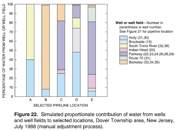
The sum of the proportionate contribution of water from all wells and well fields to any pipeline location should be 100%. Because of numerical approximation and roundoff, however, the total contribution from all wells and well fields may sum to slightly less or slightly more than 100% at some locations. Such results are expected when using numerical simulation techniques. In the historical reconstruction analysis conducted for the water-distribution system serving the Dover Township area, the sum of the proportionate contribution results at any location ranges from 98% to 101% (for example, results presented in Appendices G and H).
Table 19. Proportionate contribution results for wells and well fields for selected pipeline locations using the manual adjustment process, year, month of analysis, and location in report
[see Figure 21 or Plates 52–153 for pipeline locations; —, simulation results not presented in a graphical format for this month]
Simulation Month1 |
|||||||||||
|---|---|---|---|---|---|---|---|---|---|---|---|
January |
February |
March |
April |
May |
June |
July |
August |
September |
October |
November |
December |
|
|||||||||||
1962 |
|||||||||||
2Table G-1 |
Table G-1 |
Table G-1 |
Table G-1 |
Table G-1 |
Table G-1 |
Table G-1 |
Table G-1 |
Table G-1 |
Table G-1 |
Table G-1 |
Table G-1 |
— |
2Figure H-1 |
— |
— |
Figure H-1 |
— |
— |
— |
— |
Figure H-1 |
— |
— |
1965 |
|||||||||||
Table G-2 |
Table G-2 |
Table G-2 |
Table G-2 |
Table G-2 |
Table G-2 |
Table G-2 |
Table G-2 |
Table G-2 |
Table G-2 |
Table G-2 |
Table G-2 |
— |
Figure H-2 |
— |
— |
— |
Figure H-2 |
— |
— |
— |
Figure H-2 |
— |
— |
1971 |
|||||||||||
Table G-3 |
Table G-3 |
Table G-3 |
Table G-3 |
Table G-3 |
Table G-3 |
Table G-3 |
Table G-3 |
Table G-3 |
Table G-3 |
Table G-3 |
Table G-3 |
— |
Figure H-3 |
— |
— |
— |
— |
Figure H-3 |
— |
— |
Figure H-3 |
— |
— |
1978 |
|||||||||||
Table G-4 |
Table G-4 |
Table G-4 |
Table G-4 |
Table G-4 |
Table G-4 |
Table G-4 |
Table G-4 |
Table G-4 |
Table G-4 |
Table G-4 |
Table G-4 |
— |
Figure H-4 |
— |
— |
— |
Figure H-4 |
— |
— |
— |
Figure H-4 |
— |
— |
1988 |
|||||||||||
Table G-5 |
Table G-5 |
Table G-5 |
Table G-5 |
Table G-5 |
Table G-5 |
Table G-5 |
Table G-5 |
Table G-5 |
Table G-5 |
Table G-5 |
Table G-5 |
— |
Figure H-5 |
— |
— |
— |
— |
Figure H-5 |
— |
— |
Figure H-5 |
— |
— |
1995 |
|||||||||||
Table G-6 |
Table G-6 |
Table G-6 |
Table G-6 |
Table G-6 |
Table G-6 |
Table G-6 |
Table G-6 |
Table G-6 |
Table G-6 |
Table G-6 |
Table G-6 |
— |
Figure H-6 |
— |
— |
— |
— |
— |
Figure H-6 |
— |
Figure H-6 |
— |
— |
1996 |
|||||||||||
Table G-7 |
Table G-7 |
Table G-7 |
Table G-7 |
Table G-7 |
Table G-7 |
Table G-7 |
Table G-7 |
Table G-7 |
Table G-7 |
Table G-7 |
Table G-7 |
— |
Figure H-7 |
— |
— |
— |
Figure H-7 |
— |
— |
— |
Figure H-7 |
— |
— |
|
1February is minimum-demand month; October is average-demand month; May, June, July, or August are maximum-demand months. |
|||||||||||
Results of the proportionate contribution simulations illustrate the increasing complexity and operational variability of the distribution system throughout the historical period. As previously described, these results were obtained by conducting source-trace analysis simulations. The annual variation of the simulated proportionate contribution of water from all operating wells and well fields to selected locations in the Dover Township area is shown for the minimum-demand month of February (Figure 23), the maximum-demand months of May, June, July, or August (Figure 24), and the average-demand month of October (Figure 25). For each of these examples, the five pipeline locations previously described—A through E—were selected from the historical pipeline networks to represent the spatial distribution of proportionate contribution results.
Comparison of the May 1962 results with the June 1996 results (Figure 24) indicates the increasing complexity of the water-distribution system operations and how such operations influenced the proportionate contribution of water to specific locations. In May 1962, only two well fields (Holly and Brookside) provided water to any one location; whereas, in June 1996, as many as seven well fields provided water to any one location, such as, pipeline location E in Figure 24.
In reviewing the simulation results, the annual and seasonal variation of the proportionate contribution of water is evident by inspecting, for example, the results for pipeline location D. Annual variation is determined by selecting a certain demand conditions—minimum, maximum, or average (Figures 23, 24, or 25, respectively)—and comparing the proportionate contribution results over the historical period (1962–96). For example, for the minimum-demand month of February, for pipeline location D, results indicate (Figure 23):
Seasonal variation is determined by choosing a specific year and comparing the proportionate contribution results for the minimum-, maximum-, and average-demand months (Figures 23, 24, and 25, respectively). For example, for 1988, at pipeline location C, results indicate:
Simulation results for the maximum-demand months of May 1962, June 1965, July 1971, June 1978, July 1988, August 1995, and June 1996 for pipeline location D further exemplify the annual variation in the contribution of water to this location and indicate the following (see Figure 24 for the proportionate contribution results and Plates referenced in Table 16 for well and well field locations):
The simulation results shown in Figures 23, 24, and 25 demonstrate that the contribution of water from wells and well fields varied by time and location. However, the results also show that certain wells provided the predominant amount of water to locations throughout the Dover Township area. Discussed below are simulation results, obtained using the manual adjustment process, for the proportionate contribution of water from each operating well and well field for selected years (1962, 1965, 1971, 1978, 1988, 1995, and 1996) and selected months (minimum-, maximum, and average-demand) of the historical period.
REVIEW OF SIMULATION RESULTS FOR SELECTED YEARS AND MONTHS
Because of space limitations, it is not possible to present in this report results of the source-trace analyses for every well and well field for every month of the historical period. For example, to present the areal distribution of the simulated proportionate contribution of water from only two well fields for every month of the historical period would require 840 maps; and from June 1966 foreword, every historical water-distribution system contained more than two well fields (Appendices B and F). Accordingly, results representing several years from the 35 years of historical simulations were selected and are examples described herein23. The years selected as previously discussed are: 1962, 1965, 1971, 1978, 1988, 1995, and 1996. These selected years represent the first and last years of the historical period (1962 and 1996, respectively), peak production years (1971, 1988, and 1995, see Figures 12 and 14), a transition year and a year when a number of new wells were added (1965 and 1971, respectively), and the first year where investigators had generalized notes from the water utility describing typical peak-day (summer) and non-peak-day (fall) operations (1978). Simulated proportionate contribution results in the map and "stacked" column graph format are shown for the minimum-, maximum-, and average-demand months for the selected years (Plates 52-153 and Appendix H; see Tables 17 and 19). Simulated proportionate contribution results in tabular format are presented for every month of the selected years (Table 19; Appendix G).
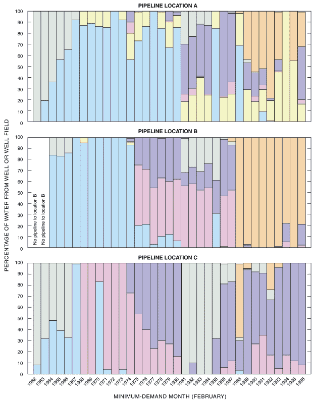
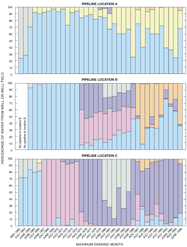
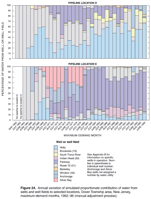
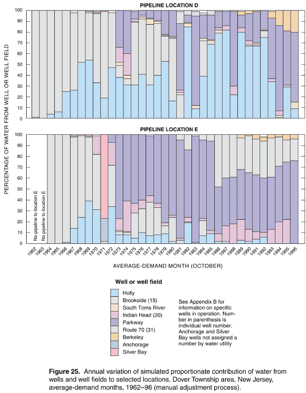
1962—February, May, and October
In 1962, the first year of the historical reconstruction analysis, the water-distribution system consisted of 2 well fields containing 3 wells (Holly wells 13 and 14; Brookside well 15) and 1 storage tank and standpipe (Horner Street) as shown on Plate 52. In 1962, total production of water was 359 Mgal (Figure 14). Production of slightly more than 40 Mgal occurred during the maximum- demand month of May (Table B-1; Figure 11). The areal distribution of the simulated proportionate contribution of water from the well fields to locations in the Dover Township area is presented on Plates 52–57 for the minimum-, maximum-, and average-demand months of February, May, and October, respectively. Graphs showing the percentage of water contributed by the two well fields to the five selected pipeline locations (A, B, C, D, and E) are shown in Figure H-1, and a tabular listing of this information for each month of 1962 is provided in Table G-1. In February and May 1962, the Holly wells did not supply any water to the western area of Dover Township and supplied only a very small amount (10% or less) in October 1962 (Plates 52, 54, 56). On the other hand, the Brookside well supplied all parts of the water-distribution system including 90% or more to the central, south-central, and eastern parts of the Dover Township area in February 1962 (Plates 53, 55, 57). Depending on the time of year, there can be significant variation in the proportionate contribution of water from a well or well field to a specific location serviced by the water-distribution system. As shown in Table G-1 and Figure H-1, the percentage of water contributed to pipeline location A in the southernmost area of Dover Township by the Holly wells in 1962 varied from 0% in February to 23% in May (maximum-demand month) to 40% in October (also compare Plates 52, 54, and 56).
1965—February, June, and October
In 1965, the water-distribution system consisted of 2 well fields containing 4 wells (Holly wells 14, 16, and 18; Brookside well 15) and 1 elevated storage tank (South Toms River), as shown on Plate 58. In 1965, total production of water was 573 Mgal (Figure 14). Production of slightly more than 64 Mgal occurred during the maximum-demand month of June (Table B-4; Figure 11). The areal distribution of the simulated proportionate contribution of water from the wells and well fields to locations in the Dover Township area is presented on Plates 58 through 63 for the minimum-, maximum-, and average-demand months of February, June, and October, respectively. Graphs showing the simulated percentage of water contributed by the well fields to the five selected pipeline locations (A–E) are shown in Figure H-2. A tabular listing of simulated results for each month of 1965 is also provided in Table G-2. By 1965, the water-distribution system had expanded to the northeasternmost part of Dover Township. This area, the easternmost, and the southeastern areas were primarily supplied by the Brookside well contributing 75% or more of the water during all demand periods (Plates 59, 61, 63). The Holly wells supplied 75% or more of the water to the southwestern and southern areas of Dover Township, including the Borough of South Toms River where these wells supplied 90% or more of the water during all demand periods (Plates 58, 60, 62). Pipeline locations D and E, located in the southeastern and northeasternmost areas of Dover Township (see Plate 58 for location), were supplied with 80% to 100% of their water by the Brookside well (15). Pipeline locations A and B, located in the southern and southwestern areas, respectively, received 56% to 100% of their water from the Holly wells. Pipeline location C, located in the west-central area of Dover Township, received 39% of its water from the Holly wells under minimum-demand conditions (February 1965) and 72% and 80% of its water under maximum- and average-demand conditions, respectivel (June 1965 and October 1965; Table G-2 and Figure H-2).
1971—February, July, and October
In 1971, the water-distribution system consisted of 7 well fields containing 14 wells (Holly wells 14, 16, 18, 19, and 21; Brookside well 15; South Toms River well 17; Indian Head well 20, Parkway wells 22, 23, 26, and 27; Anchorage well; and Silver Bay well), 3 ground-level storage tanks (Holly plant (2 tanks) and Parkway) and 2 elevated storage tanks (South Toms River and Indian Hill), as shown on Plate 64. The areal distribution of the simulated proportionate contribution of water from the wells and well fields to locations in the Dover Township area is presented on Plates 64 through 82 for the minimum-, maximum-, and average-demand months of February, July, and October, respectively. Graphs showing the simulated percentage of water contributed by the well fields to the five selected pipeline locations (A-E) are shown in Figure H-3. A tabular listing of simulated results for each month of 1971 is also provided in Table G-3. The configuration and operation of the 1971 water-distribution system illustrates the growth and operational complexity of the system (compare Plates 64 and 58; Figures H-2 and H-3). The Holly wells primarily contributed water to the southern and southwesternmost areas of the distribution system (Plates 64, 70, 77). Note that with well fields such as Holly, which contain multiple wells, not all wells were pumped or were in service during the entire year. For example, in February and October 1971 (minimum- and average-demand conditions), only Holly wells 16, 18, and 19 were operating (Plates 64 and 77; Table B-10), whereas the well field consisted of wells 14, 16, 18, 19, and 21. All of these wells were operated under maximum-demand conditions in July 1971 (Plate 70; Table B-10).
In 1971, demand and consequently production of water were at all-time highs, reaching a total annual production of 1,449 Mgal (Figure 14). Production of more than 230 Mgal occurred during the maximum-demand month of July (Table B-10; Figures 11 and 12). The Indian Head well contributed 90% or more of the water to locations along the northwesternmost part of the distribution system (Plate 67) in February 1971, more than 50% of the water in July (Plate 73), and more than 25% of the water in October (Plate 80). The Anchorage and Silver Bay wells, located in the northeasternmost area of Dover Township (Plates 68, 69, 75, 76, 81, 82), were also in service in 1971. These wells were used primarily to service and augment demand in the vicinity of the well locations.
In 1971, four Parkway wells (22, 23, 26, and 27) were brought on line to meet the maximum-demand conditions occurring in July (Plate 74; Figure H-3; Table G-3; Table B-10). These wells contributed water in varying amounts of up to 75%, with an average simulated contribution of about 25%, to all areas of the distribution system except for the southernmost and southwesternmost areas of Dover Township and the Borough of South Toms River.
1978—February, June, and October
In 1978, the water-distribution system consisted of 7 well fields containing 17 wells (Holly wells 16, 18, 19, and 21; Brookside well 15; South Toms River well 17; Indian head well 20; Parkway wells 22-29; Anchorage well; and Silver Bay well), 5 ground-level storage tanks (Holly Plant (2 tanks), Parkway, Holiday City, and Route 37), and 2 elevated storage tanks (South Toms River and Indian Hill) as shown on Plate 83. The areal distribution of the simulated proportionate contribution of water from the wells and well fields to locations in the Dover Township area is presented on Plates 83 through 98 for the minimum-, maximum-, and average-demand months of February, June, and October, respectively. Graphs showing the simulated percentage of water contributed by the well fields to the five selected pipeline locations (A-E) are shown in Figure H-4. A tabular listing of simulated results for each month of 1978 is also provided in Table G-3. By 1978, the operations of the water-distribution system had been configured so that the Parkway wells were contributing water to all locations throughout the Dover Township area (Plates 86, 91, 98; Figure H-4; Tables G-4), except for the Borough of South Toms River. This area was primarily supplied by the Holly wells (Plates 83, 87, 94) and the South Toms River well (Plates 84, 89, 96), as exempli- fied by the contribution of water to pipeline location A shown in Figure H-4.
In 1978, total production of water was 2,191 Mgal (Figure 14). Production of more than 273 Mgal occurred during the maximum-demand month of July (Table B-17; Figure 11). During 1978, simulation results indicate that the Holly wells contributed 75% or more of the water to the southernmost area of Dover Township and 10% to 100% of the water to the Berkeley Township area serviced by the water-distribution system in February, June, and October (Plates 83, 87, 94). The Indian Head well contributed 90% or more of the water to locations along the northwesternmost part of the water-distribution system in February and October (Plates 85, 97), and more than 50% of the water during the maximum- demand month of June (Plate 90). Most of the water contributed by the Indian Head well flowed primarily to the northwest as exemplified by the contribution of water to pipeline location A (Figure H-4). This location, supplied solely by the Indian Head and Parkway wells (Table G-4), is located to the east of the Indian Head well (Plate 85) and, therefore, obtained most of its water (70% or more) in February, June, and October from the Parkway wells.
Unlike the operations of the water-distribution system in the early years of the historical period, in 1978 the Brookside well was operated on a limited basis and simulation results indicate a contribution of water of 50% or less to locations in eastern and northeasternmost areas of Dover Township (Plates 88, 95). This method of operating the Brookside well is clearly seen by comparing the simulated proportionate contribution of water from the Brookside well to the five selected pipeline locations for 1965 and 1978 (compare Figures H-2 and H-4, respectively).
In 1978, the Anchorage and Silver Bay wells were used solely for the maximum-demand month of June (Plates 92 and 93). As described above for 1971 conditions, these wells were used primarily to service and augment demand in the areas that were in the vicinity of the well locations; that is, the northeasternmost part of Dover Township. The Silver Bay well was taken completely out of service after August 1980 (Table B-19) and the Anchorage well was used solely for an average of 2 hours per day in July 1981 (Table B-20) and 5 hours per day in June 1984 (Table B-23), after which time, it was taken completely out of service.
1988—February, July, and October
In 1988, the water-distribution system consisted of 7 well fields containing 16 wells (Holly wells 21 and 30; Brookside well 15; South Toms River wells 32 and 38; Indian Head well 20; Parkway wells 22-24, 26, 28, and 29; Route 70 well 31; Berkeley wells 33, 34, and 35), 6 ground-level storage tanks (Holly Plant (2 tanks), Parkway, Holiday City, Route 37, and Windsor), and 2 elevated storage tanks (South Toms River and Indian Hill), as shown on Plate 99. The areal distribution of the simulated proportionate contribution of water from the wells and well fields to locations in the Dover Township area is presented on Plates 99 through 117 for the minimum-, maximum-, and average-demand months of February, July, and October, respectively. Graphs showing the simulated percentage of water contributed by the points of entry to the five selected pipeline locations (A-E) are shown in Figure H-5. A tabular listing of the percentage of water contributed by each water source for each month of 1988 is also provided in Table G-5.
By 1988, demand and consequently production of water were at all-time highs, reaching a total annual production of 3,441 Mgal (Figure 14). Production of nearly 433 Mgal occurred during the maximum-demand month of July (Table B-27; Figures 11 and 12). In February 1988, most of the water supplied to the water-distribution system was contributed by Holly well 30 and by Berkeley wells 33 and 34 (Plates 99, 104). Simulated proportionate contribution results indicate that the Brookside well and South Toms River well 32 contributed 25% or less of the water to the southeasternmost, eastern, and northeasternmost areas of Dover Township (Plates 100; 101).
Simulation results show that the Parkway wells contributed water to the central and northern areas of Dover Township in varying percentages during 1988, depending on the time of year and demand conditions (Plates 102, 109, 115). The water contributed by the Parkway wells was as little as about 10% in February at pipeline location D (Figure H-5), 80% or more in October at pipeline location C, and was nearly 100% of the water contributed to locations in the central area of Dover Township in October (Plate 115).
The Route 70 well was part of the water-distribution system in 1988 (Plates 103, 110, 116) and was primarily used to supply water to locations along the northwesternmost part of the Dover Township area. In previous years, this part of the network was supplied by the Indian Head well. The Route 70 well also contributed water to the northernmost and northeasternmost areas of Dover Township throughout 1988. The Berkeley wells, brought into service in 1986 (Table B-25), were used as the primary source of water for that part of the distribution system serving the Berkeley Township area. In 1988, based on simulated proportionate contribution results, these wells contributed 90% or more of the water to the Berkeley Township area (Plates 104, 111, 117). In February, Berkeley wells 33 and 34 contributed up to 25% of the water to eastern areas (including the southeasternmost and northeasternmost areas) of Dover Township; whereas in July and October the simulated percentage of water from all three Berkeley wells (33, 34, and 35) was 10% or less to this part of the network.
1995—February, August, and October
In 1995, the water-distribution system consisted of 8 well fields containing 20 wells (Holly wells 21, 30, and 37; Brookside well 15; South Toms River wells 32 and 38; Indian Head well 20; Parkway wells 22, 24, 26, 28, 29, 39, 41, and 42; Route 70 well 31; Berkeley wells 33, 34, and 35; Windsor well 40), 6 ground-level storage tanks (Holly Plant (2 tanks), Parkway, Holiday City, Route 37, and Windsor), and 3 elevated storage tanks (South Toms River, Indian Hill, and North Dover), as shown on Plate 118. The areal distribution of the simulated proportionate contribution of water from the wells and well fields to locations in the Dover Township area is presented on Plates 118 through 136 for the minimum-, maximum-, and average-demand months of February, August, and October, respectively. Graphs showing the percentage of water contributed by the points of entry to the five selected pipeline locations (A-E) are shown in Figure H-6. A tabular listing of the percentage of water contributed by each water source for each month of 1995 is also provided in Table G-6.
Production of water to meet demand in 1995 exceeded all other years of the historical period with respect to total annual production of 3,985 Mgal (Figure 14). The maximum-monthly production of nearly 514 Mgal occurred in August (Table B-34; Figures 11 and 12). For minimum-demand conditions (February), most of the water was contributed by the Parkway wells (Plate 120) and the Berkeley wells (Plate 122). In February, the Holly wells did not contribute any water to the distribution system (Figure H-6). During the maximum-demand month (August), most of the water was contributed by the Holly wells (Plate 123) and the Parkway wells (Plate 127), with the Berkeley wells supplying the Berkeley Township area and a very small area of southwesternmost Dover Township (Plate 129; Figure H-6). During the average-demand month (October), most of the water was contributed by Holly well 30 (Plate 131), the Parkway wells (Plate 133), and the Berkeley wells (Plate 135). In October, the Berkeley wells contributed water to every part of Dover Township serviced by the water-distribution system (Plate 135; Figure G-H) with the exception of the northwesternmost area, which received most of its water from the Route 70 well (Plate 134).
The South Toms River wells contributed 90% or more of the water to the Borough of South Toms River in February (Plate 118) and August (Plate 125), and less than 50% of the water to the southeasternmost and eastern areas of Dover Township. The Indian Head well did not contribute significantly to demand in 1995, except in the area immediately near the well. In fact, the simulated proportionate contribution of water from this well in 1995 was generally less than 30% in areas away from the immediate vicinity of the well at any given time during February, August, or October (Plates 119, 126, 132; Figure H-6).
Windsor well 40, which began operations in June 1991 (Table B-30), was used primarily to contribute water to the southeasternmost area of Dover Township. The areal distribution of the simulated proportionate contribution of water from this well is shown for the first time for the selected year of 1995 (Plates 130, 136). Typically, the Windsor well would be operated during the maximum-demand months of the summer and through the average-demand month of October (Tables B-30 through B-34).
1996—February, June, and October
In 1996, the final year of the historical reconstruction analysis, the water-distribution system consisted of 8 well fields containing 20 wells (Holly wells 21, 30, and 37; Brookside well 15; South Toms River wells 32, and 38; Indian Head well 20; Parkway wells 22, 24, 26, 28, 29, 39, 41, and 42; Route 70 well 31; Berkeley wells 33, 34, and 35; Windsor well 40), 6 ground-level storage tanks (Holly Plant (2 tanks), Parkway, Holiday City, Route 37, and Windsor), and 3 elevated storage tanks (South Toms River, Indian Hill, and North Dover), as shown on Plate 137. The areal distribution of the simulated proportionate contribution of water from the wells and well fields to locations in the Dover Township area is presented on Plates 137 through 153 for the minimum-, maximum-, and average-demand months of February, June, and October, respectively. Graphs showing the percentage of water contributed by the wells and well fields to the five selected pipeline locations (A–E) are shown on Figure H-7. A tabular listing of the percentage of water contributed by each water source for each month of 1996 is also provided in Table G-7.
Annual and monthly production of water required to meet demand in 1996 was less than that required in 1995. Total annual production was 3,873 Mgal (Figure 14), and 417 Mgal were produced during the maximum-demand month of June (Table B-35; Figure 11). Other- wise, the 1996 water-distribution system was operated in a manner similar to the 1995 water-distribution system; however, in 1996, the Parkway wells contributed more water overall to the distribution system in February 1996 (Figure H-7) than they did in February 1995. In February 1996, the Parkway wells contributed water to all locations in the Dover Township area with the exceptions of Berkeley Township and some areas of northernmost and northwestern Dover Township (Plate 139). In June 1996, the Parkway wells contributed water to all areas of Dover Township except Berkeley Township and southeasternmost Dover Township (Plate 145). In October 1996, Parkway wells again contributed water to all parts of Dover Township except Berkeley Township and northwesternmost Dover Township (Plate 151). The higher percentage contribution of water by the Parkway wells in 1996 compared to 1995 is evident on these maps (Plates 139, 145, 151) by the 90% or more contribution of water classification covering a signifi- cantly larger area of Dover Township in comparison to previous years.
The Brookside well was operated in a similar manner during 1995 and 1996, and was used solely during the summer to meet the maximum-demand conditions. In June 1996, the simulated proportionate contribution from the Brookside well to the pipeline network was approximately no more than 25% and generally less than 10% in the eastern and northeasternmost areas of Dover Township (Plate 143; Figure H-7). The South Toms River wells were operated during every month of 1996 except December (Table B-35). These wells contributed 50% to 100% of the water to the Borough of South Toms River area during the entire year (Plates 137, 144, 150; Figure H-7) as well as contributing up to 75% of the water to locations in the southeasternmost areas of Dover Township during the average-demand month of October (Plate 150).
The Indian Head well was operated for 6 months during 1996 (Table B-35) and did not operate during the maximum-demand month of June. It was operating during the minimum-demand month of February (Plate 138; Figure H-7; Table G-7). Except for the area in the vicinity and slightly northwest of the well, the contribution of water from this well to the pipeline network was limited everywhere to approximately 50% or less, and generally 10% or less in Dover Township.
Although the Route 70 well was operated during every month of 1996 (Table B-35), its contribution of water to the pipeline network was generally limited to the northernmost areas of Dover Township (Plates 140, 146, 152). The simulated percentage contribution of water from the Route 70 well varied from 90% or more to the northwesternmost areas of Dover Township to 10% or less in the northeasternmost areas.
The Berkeley wells contributed 75% or more of the water to locations in the Berkeley Township area of the distribution system in February (Plate 141), June (Plate 147), and October (Plate 153). In February, the Berkeley wells contributed 50% or less to the total water demand in the southeasternmost part of Dover Township. In June and October, the Berkeley wells contributed less than 25% and, generally, 10% or less of the total water distributed to the central and northeasternmost areas of Dover Township (Figures H-7).
Windsor well 40 was used primarily to supply water to the southeasternmost part of the Dover Township area in 1996 and the areal distribution of the simulated proportionate contribution of water from this well is shown for June 1996 on Plate 148. Generally, the Windsor well contributed at least 75% of the water to the southeastern area of Dover Township in the vicinity of the well. It additionally contributed 25% or less of the water to locations in the easternmost and northeasternmost areas of Dover Township (Figures H-7; Table G-7). Typically, the Windsor well was operated during the maximumdemand months of the summer, although in 1996 it was also operated in November and December (Table B-35).
The detailed results presented for the seven selected years demonstrate that the contribution of water from operating wells and well fields could vary significantly by time and location. However, as discussed previously, these results also show that certain wells and well fields did provide the predominant amount of water to locations throughout the Dover township area serviced by the historical distribution system.
OVERVIEW
Model parameter uncertainty and variability may occur because of spatial and temporal variability of data, incomplete or missing data, or measurement errors. Sensitivity analyses are typically conducted as part of a model calibration process to assess changes in simulation results when adjustments or modifications are made to certain model parameters (Walski et al. 2001). For example, a sensitivity analysis was conducted as part of the model calibration process for the present-day (1998) water-distribution system serving the Dover Township area and was used to assess changes in simulation results caused by variations in pipe diameters and pipe roughness coefficients (Maslia et al. 2001, p. 51). Sensitivity analyses conducted as part of the historical reconstruction of water-distribution system operations were designed to assess changes in the percentage of water contributed by a well or well field to pipeline locations (proportionate contribution) rather than to assess changes in the simulated hydraulics of the distribution system. Output from the source-trace analyses—the simulated proportionate contribution of water—will be considered as one of the risk factors in the epidemiologic case-control investigation. If large but reasonable variations in model parameter values result in correspondingly large variations in the percentage of water contributed by a well or well field to pipeline locations, the estimates of exposure to the different water sources may result in exposure misclassification. On the other hand, if changes in the simulated proportionate contributions are small regardless of the magnitude change in model parameters, then simulation variability will not greatly detract from the confidence assigned to exposure classifications. The bases of comparison for all sensitivity analysis results were the corresponding results obtained through the manual adjustment process—previously described in the section on "Historical Reconstruction Analysis."
VARIATION OF OPERATIONAL AND HYDRAULIC CONSTRAINTS
Four types of operational and hydraulic constraints were varied during sensitivity analyses in order to determine the effects of constraint changes on the simulated proportionate contribution results. The constraints subjected to variation were:
Genetic Algorithm (GA) optimization methods25 were used to conduct sensitivity analyses of the first three constraints or constraint sets. Proportionate contributions were simulated at all pipeline locations for each constraint change, and these results were compared with corresponding results obtained using the manual adjustment process. Sensitivity analyses of the fourth constraint were obtained using the manual adjustment process. Descriptions of constraints varied during the sensitivity analyses are listed in Table 20. The month and year for which sensitivity analyses results were obtained are listed in Table 21. For the sensitivity analyses that used the GA optimization methods (SENS0–SENS7), initial estimates for the on-and-off cycling patterns and pattern factors for the groundwater wells and supply nodes were derived from the manual adjustment process. This approach guaranteed that the GA simulation would begin with balanced flow conditions. Simulation SENS0 was conducted for every month of the historical period (420 months) which included the months shown in Table 21. Simulation SENS1 was conducted for every month of selected years 1962, 1965, 1971, 1978, 1988, and 1996. Sensitivity analyses SENS2–SENS7 were conducted for three selected months of the aforementioned selected years. The three selected months corresponded to the minimum-, maximum-, and average-demand months. (The rationale for conducting sensitivity analyses for selected months and years of the historical period for simulations SENS1–SENS7 will be discussed below.) Sensitivity analyses SENS8 were conducted solely for the three selected months of 1996 because hourly operational data were required to conduct the month-long simulations, and these data, obtained from the water utility (Flegal 1997), were only available for 1996.
Table 20. Description of operational and hydraulic contraints varied for sensitivity analyses1
[GA, genetic algorithm optimization; MAP, manual adjustment process]
Type of Variation |
Sensitivity Simulation Identification |
Method of Simulation |
Description of Parameter Variation and |
|---|---|---|---|
Well- and supply node-pattern factors |
SENS0 |
GA |
Minimum allowable pressure, 15 psi; maximum allowable pressure, 110 psi; difference between storage tank starting and ending water level in a 24-hour period, 0.0 ft |
SENS1 |
GA |
Alternative well pattern-factors that are not as optimal as simulation SENS0, but still provide a system operation that satisfies constraints. Minimum allowable pressure, 15 psi; maximum allowable pressure, 110 psi; difference between storage tank starting and ending water level in a 24-hour period, 0.0 ft |
|
SENS2 |
GA |
Minimum allowable pattern factor, 0.25; minimum allowable pressure, 15 psi; maximum allowable pressure, 110 psi; difference between storage tank starting and ending water level in a 24-hour period, 0.0 ft |
|
SENS3 |
GA |
Minimum allowable pattern factor, 0.75; maximum allowable pattern factor, 1.25; minimum allowable pressure, 15 psi; maximum allowable pressure, 110 psi; difference between storage tank starting and ending water level in a 24-hour period, 0.0 ft |
|
|
|||
Minimum pressure criteria |
SENS4 |
GA |
Minimum allowable pattern factor, 0.15; minimum allowable pressure, 20 psi; maximum allowable pressure, 110 psi; difference between storage tank starting and ending water level in a 24-hour period equal, 0.0 ft |
SENS5 |
GA |
Minimum allowable pattern factor, 0.15; Minimum allowable pressure, 30 psi; maximum allowable pressure, 110 psi; difference between storage tank starting and ending water level in a 24-hour period, 0.0 ft |
|
|
|||
Storage tank water-level difference criteria |
SENS6 |
GA |
Minimum allowable pattern factor, 0.15; minimum allowable pressure, 20 psi; maximum allowable pressure, 110 psi; difference between storage tank starting and ending water level in a 24-hour period, 3.0 ft |
SENS7 |
GA |
Minimum allowable pattern factor, 0.15; minimum allowable pressure, 30 psi; maximum allowable pressure, 110 psi;; difference between storage tank starting and ending water level in a 24-hour period, 3.0 ft) |
|
|
|||
Daily system operations |
SENS8 |
MAP |
Variation of hourly pattern factors over a month-long period (696-744 hours). Minimum allowable pressure, 15 psi; maximum allowable pressure, 110 psi; difference between storage tank starting and ending water level over the month-long period, 0.0 ft |
|
1The bases of comparison for all sensitivity analyses (SENS0–SENS8) are proportiate contributions derived using the manual adjustment process described in the "Historical Reconstruction Analysis" section. |
|||
Well- and Supply-Node-Pattern Factors
Because of the variability and lack of definitive data regarding the hourly on-and-off cycling of wells and high-service and booster pumps for the historical period, testing changes in simulation results in conjunction with changes in on-and-off cycling of wells and pumps was considered a critical feature of the sensitivity analyses. As described above, GA optimization methods were used to develop alternative schedules for operating the water-distribution system for every month of the historical period. Sensitivity analyses SENS0 were designed to modify the EPANET 2 pattern factors in order to vary well- and supply-node-operating patterns. Hydraulically balanced and optimal or near optimal operating conditions were achieved using pressure and storage tank water-level criteria described by the "Master Operating Criteria" (Table 4 and Table 20). Following the simulation of an alternative balanced flow system using GA methods, source-trace analyses were conducted in the manner previously described (see "Water-Quality Modeling [Source-Trace Analysis"] section) to obtain proportionate contributions of water at all pipeline locations.
The effects of varying schedules and pattern factors on the simulated proportionate contributions of water at pipeline locations were unknown prior to conducting the sensitivity analyses SENS0. Accordingly, these simulations were conducted for every month of the historical period (Table 21). Subsequent analyses of SENS0 simulation results (see section on "Results of Sensitivity Analyses") indicated that the historical water-distribution system successfully operated only within a narrow range of conditions. Successful operation included maintaining a balanced flow condition and satisfying the "Master Operating Criteria" previously described (Table 4). Therefore, the remaining sensitivity analyses (SENS1–SENS7) were conducted solely for representative years and months listed in Table 21.
In response to recommendations from the external expert panel (ATSDR 2001e), sensitivity analyses using GA optimization methods were conducted to simulate a pattern of system operation as different as possible from the operating patterns developed by the manual adjustment process used for sensitivity analyses SENS0. Substantially different operating patterns were developed using GA optimization methods and were designated SENS1 (Table 20). The resulting pattern factors for SENS1 simulations were not as optimal as the results derived from sensitivity analyses SENS0, but nonetheless resulted in acceptable system operations that satisfied the "Master Operating Criteria." (See Aral et al. 2001b and Appendix E for details and a description of the development of the alternate set of pattern factors.) Sensitivity analyses SENS1 were conducted for every month of selected years 1962, 1965, 1971, 1978, 1988, and 1996 (Table 21). After reviewing results it was apparent that the complete range of results of the effects of constraint variation could be characterized by conducting sensitivity analyses just for the three annual demand conditions (minimum, maximum, and average). Therefore, all other sensitivity analyses (SENS2–SENS7) were conducted only for the minimum-, maximum-, and average-demand months of the aforementioned selected years (Table 21).
Pattern factors derived using the manual adjustment process as well as those obtained from sensitivity analyses SENS0 and SENS1 were allowing wells and supply nodes representing wells linked to storage tanks and high-service and booster pumps to operate at a fraction of their pumping capacities. In some instances, the resulting pattern factors were near zero in value. To limit this occurrence, pattern factors obtained from sensitivity analyses SENS2 were constrained to a minimum value of 0.25 (the default value for a pattern factor in EPANET 2 is 1.0). The pressure and storage tank water-level constraints imposed on the previous sensitivity analyses were also imposed on sensitivity analyses SENS2 (Table 20).
The final test of changes of well- and supply-node-pattern factors on simulation results was designated sensitivity analyses SENS3. Analyses SENS3 were conducted to test the operational status of wells and highservice and booster pumps; that is, pumps must be either "on" or "off." To address this issue, pattern factors for operating wells and supply nodes representing wells linked to storage tanks and high-service and booster pumps were constrained to values of 0.75–1.25. Otherwise, a value of 0.0 (indicating the well or supply node was in the "off" position) was applied. The pressure and storage tank water-level constraints imposed on the previous sensitivity analyses were also imposed on analyses SENS3 (Table 20).
Table 21. Identification of year and month for conducting sensitivity analysis simulations
[—, sensitivity analysis simulation not conducted for this month]
Year |
Month |
Sensitivity Analysis Simulation Identification1 |
||||||||
|---|---|---|---|---|---|---|---|---|---|---|
|
SENS02 |
SENS1 |
SENS2 |
SENS3 |
SENS4 |
SENS5 |
SENS6 |
SENS7 |
SENS8 |
|
January |
X |
X |
— |
— |
— |
— |
— |
— |
— |
|
February3 |
X |
X |
X |
X |
X |
X |
X |
X |
— |
|
March |
X |
X |
— |
— |
— |
— |
— |
— |
— |
|
|
||||||||||
April |
X |
X |
— |
— |
— |
— |
— |
— |
— |
|
May4 |
X |
X |
X |
X |
X |
X |
X |
X |
— |
|
June |
X |
X |
— |
— |
— |
— |
— |
— |
— |
|
1962 |
|
|||||||||
July |
X |
X |
— |
— |
— |
— |
— |
— |
— |
|
August |
X |
X |
— |
— |
— |
— |
— |
— |
— |
|
September |
X |
X |
— |
— |
— |
— |
— |
— |
— |
|
|
||||||||||
October5 |
X |
X |
X |
X |
X |
X |
X |
X |
— |
|
November |
X |
X |
— |
— |
— |
— |
— |
— |
— |
|
December |
X |
X |
— |
— |
— |
— |
— |
— |
— |
|
|
||||||||||
January |
X |
X |
— |
— |
— |
— |
— |
— |
— |
|
February3 |
X |
X |
X |
X |
X |
X |
X |
X |
— |
|
March |
X |
X |
— |
— |
— |
— |
— |
— |
— |
|
|
||||||||||
April |
X |
X |
— |
— |
— |
— |
— |
— |
— |
|
May |
X |
X |
— |
— |
— |
— |
— |
— |
— |
|
June4 |
X |
X |
X |
X |
X |
X |
X |
X |
— |
|
1965 |
|
|||||||||
July |
X |
X |
— |
— |
— |
— |
— |
— |
— |
|
August |
X |
X |
— |
— |
— |
— |
— |
— |
— |
|
September |
X |
X |
— |
— |
— |
— |
— |
— |
— |
|
|
||||||||||
October5 |
X |
X |
X |
X |
X |
X |
X |
X |
— |
|
November |
X |
X |
— |
— |
— |
— |
— |
— |
— |
|
December |
X |
X |
— |
— |
— |
— |
— |
— |
— |
|
|
||||||||||
January |
X |
X |
— |
— |
— |
— |
— |
— |
— |
|
February3 |
X |
X |
X |
X |
X |
X |
X |
X |
— |
|
March |
X |
X |
— |
— |
— |
— |
— |
— |
— |
|
|
||||||||||
April |
X |
X |
— |
— |
— |
— |
— |
— |
— |
|
May |
X |
X |
— |
— |
— |
— |
— |
— |
— |
|
June |
X |
X |
— |
— |
— |
— |
— |
— |
— |
|
1971 |
|
|||||||||
July4 |
X |
X |
X |
X |
X |
X |
X |
X |
— |
|
August |
X |
X |
— |
— |
— |
— |
— |
— |
— |
|
September |
X |
X |
— |
— |
— |
— |
— |
— |
— |
|
|
||||||||||
October5 |
X |
X |
X |
X |
X |
X |
X |
X |
— |
|
November |
X |
X |
— |
— |
— |
— |
— |
— |
— |
|
December |
X |
X |
— |
— |
— |
— |
— |
— |
— |
|
|
||||||||||
January |
X |
X |
— |
— |
— |
— |
— |
— |
— |
|
February3 |
X |
X |
X |
X |
X |
X |
X |
X |
— |
|
March |
X |
X |
— |
— |
— |
— |
— |
— |
— |
|
|
||||||||||
April |
X |
X |
— |
— |
— |
— |
— |
— |
— |
|
May |
X |
X |
— |
— |
— |
— |
— |
— |
— |
|
June4 |
X |
X |
X |
X |
X |
X |
X |
X |
— |
|
1978 |
|
|||||||||
July |
X |
X |
— |
— |
— |
— |
— |
— |
— |
|
August |
X |
X |
— |
— |
— |
— |
— |
— |
— |
|
September |
X |
X |
— |
— |
— |
— |
— |
— |
— |
|
|
||||||||||
October5 |
X |
X |
X |
X |
X |
X |
X |
X |
— |
|
November |
X |
X |
— |
— |
— |
— |
— |
— |
— |
|
December |
X |
X |
— |
— |
— |
— |
— |
— |
— |
|
|
||||||||||
January |
X |
X |
— |
— |
— |
— |
— |
— |
— |
|
February3 |
X |
X |
X |
X |
X |
X |
X |
X |
— |
|
March |
X |
X |
— |
— |
— |
— |
— |
— |
— |
|
|
||||||||||
April |
X |
X |
— |
— |
— |
— |
— |
— |
— |
|
May |
X |
X |
— |
— |
— |
— |
— |
— |
— |
|
June |
X |
X |
— |
— |
— |
— |
— |
— |
— |
|
1988 |
|
|||||||||
July4 |
X |
X |
X |
X |
X |
X |
X |
X |
— |
|
August |
X |
X |
— |
— |
— |
— |
— |
— |
— |
|
September |
X |
X |
— |
— |
— |
— |
— |
— |
— |
|
|
||||||||||
October5 |
X |
X |
X |
X |
X |
X |
X |
X |
— |
|
November |
X |
X |
— |
— |
— |
— |
— |
— |
— |
|
December |
X |
X |
— |
— |
— |
— |
— |
— |
— |
|
|
||||||||||
January |
X |
X |
— |
— |
— |
— |
— |
— |
— |
|
February3 |
X |
X |
X |
X |
X |
X |
X |
X |
— |
|
March |
X |
X |
— |
— |
— |
— |
— |
— |
— |
|
|
||||||||||
April |
X |
X |
— |
— |
— |
— |
— |
— |
— |
|
May |
X |
X |
— |
— |
— |
— |
— |
— |
— |
|
June4 |
X |
X |
X |
X |
X |
X |
X |
X |
— |
|
1996 |
|
|||||||||
July |
X |
X |
— |
— |
— |
— |
— |
— |
— |
|
August |
X |
X |
— |
— |
— |
— |
— |
— |
— |
|
September |
X |
X |
— |
— |
— |
— |
— |
— |
— |
|
|
||||||||||
October5 |
X |
X |
X |
X |
X |
X |
X |
X |
— |
|
November |
X |
X |
— |
— |
— |
— |
— |
— |
— |
|
December |
X |
X |
— |
— |
— |
— |
— |
— |
— |
|
|
1See Table 20 for definitions of sensitivity analysis simulation identifications. |
||||||||||
Minimum Pressure Criteria
The simulations of historical distribution-system operations based on the manual adjustment process were constrained by a minimum allowable pressure requirement of 15 psi and a maximum allowable pressure requirement of 110 psi at all model node locations (Table 4). Based on the configuration, hydraulics, and operations of the historical distribution systems, these pressure constraints were sufficient to ensure that, at all interior points of the model network, pressure was generally above 30 psi and less than 110 psi. The panel of experts who reviewed this simulation approach recommended that additional simulations be conducted where the pressure constraints were varied beyond the minimum and maximum constraints described by the "Master Operating Criteria" (Table 4). Because the minimum pressure constraint of 15 psi was the more difficult constraint to maintain during the manual adjustment process, and because minimum system pressure is required for fire and health protection, two sets of sensitivity analyses were conducted whereby the minimum pressure required at all interior points of the model network was varied and constrained to be 20 psi (SENS4) and 30 psi (SENS5)—Tables 20 and 21. While simulating the minimum pressure constraints of 20 and 30 psi, the maximum allowable pressure constraint of 110 psi and the storage tank water level requirement (no change over a 24-hour period) applied during the manual adjustment simulations were maintained. As with the previously described sensitivity analyses, the GA optimization methods were used to determine the operating schedule for wells and high-service and booster pumps, and the results of the manual adjustment process simulations were used as the bases for comparison.
Storage Tank and Water-Level Difference Criteria
The historical reconstruction simulations conducted using the manual adjustment process and sensitivity analyses SENS0–SENS5 applied the constraint that starting and ending water levels in storage tanks (over a 24-hour simulation period) were equal (Table 20). This constraint was imposed, in part, because of the simulation requirements of the source-trance analyses used to determine proportionate contributions. As previously described (see section on "Water-Quality Modeling [Source-Trace Analyses]"), prior to retrieving results form the source-trace analysis, the hydraulic features of the distribution system were simulated until a state of stationary water-quality dynamics was achieved, which for the historical networks was about 1,200 simulation hours.26 If the water level in a storage tank at the end of a 24-hour simulation period (hour 24) varied signifi- cantly from the water level at the start of the simulation period (hour 0), then by the time a state of stationary water-quality dynamics was reached (if stationary water-quality dynamics could be reached under these conditions), the tank was either completely drained or was overflowing. Both of these conditions were in violation of the "Master Operating Criteria" (Table 4). To test the sensitivity of the simulated values of proportionate contribution by relaxing the storage tank water-level constraint, and in response to a recommendation from the panel of experts (ATSDR 2001e), two additional sensitivity analyses were conducted—SENS6 and SENS7 (Tables 20 and 21). For both analyses, the starting and ending water level in any storage tank was permitted to vary by as much as 3.0 ft over a 24-hour simulation period. Minimum pressure requirements of 20 psi (SENS6) or 30 psi (SENS7) were also maintained. As with all previous sensitivity analyses, GA optimization methods were used to determine the operating schedule for wells and high-service and booster pumps, and the results of the manual adjustment process simulations were used as the bases for comparison.
Daily System Operations
For the historical reconstruction analysis, the assumption was made that daily system operations over a period of one month could be represented by a "typical" 24-hour day for each month of the historical period, as previously described in the section on "System Operations." This assumption was the basis for conducting the simulations using the manual adjustment process and sensitivity analyses SENS0–SENS7 that used GA optimization methods. To test the validity of this assumption, and in response to recommendations from the external expert panel, additional sensitivity analyses were conducted—designated sensitivity analyses SENS8 (Table 20 and 21). To conduct these sensitivity analyses, historical hourly operational data were required, and the only time such data were available dur- ing 1996 (Flegal 1997). Therefore, sensitivity analyses SENS8 were conducted using the manual adjustment process for the minimum-, maximum-, and average-demand months of February, June, and October 1996, respectively. For each of these months, a simulation time was used corresponding to the number of hours in the month—696 hours (29 days) for February, 720 hours (30 days) for June, and 744 hours (31 days) for October. Simulations were conducted using the operating schedule information obtained from the water utility while still honoring the "Master Operating Criteria" (Table 4). The results of sensitivity analyses SENS8 were compared to simulations of the "typical" 24-hour day for each respective month (Table G-7 and Figure H-7).
RESULTS OF SENSITIVITY ANALYSES
Genetic Algorithm (GA) Optimization Simulations
An example of simulated proportionate contribution results obtained from sensitivity analyses SENS0 is shown in Figure 26. Simulated proportionate contribution results for model nodes (pipeline junctions) are shown for the maximum-demand month of July 1988 using the Parkway well field as the point of entry. Comparison of simulation results in Figure 26—obtained using the GA optimization methods—with the corresponding simulated proportionate contribution results obtained using the manual adjustment process (Figure 21), shows little difference. Results shown in Figures 21 and 26 are nearly identical. Results are also presented using the "stacked" column graph format.27 For this method of presentation, simulation results obtained from sensitivity analyses SENS0 are shown for five geographically distinct pipeline locations (A–E). These graphs are used to show the spatial distribution of the simulated proportionate contribution of water from all operating wells and well fields for a specified historical time. Using 1988 as an example, a comparison of the simulated proportionate contribution of water from wells and well fields to the five selected pipeline locations derived from the manual adjustment process and sensitivity analyses SENS0 (Figure 27) indicate that results are nearly identical. The graphs in Figure 27 further demonstrate that, at specific historical pipeline locations in the Dover Township area, the difference between results obtained using the two simulation approaches is insignificant.
A comparison of simulation results—obtained from sensitivity analyses SENS0—to corresponding results obtained using the manual adjustment process for each month of the historical period, indicated that the simulated proportionate contributions of water were highly similar regardless of the simulation approach. Because of this, and, owing to space limitations, simulated proportionate contribution results, derived from sensitivity analyses will not be shown using the map format (except for the example shown in Figure 26). Rather, proportionate contribution results, obtained from sensitivity analyses SENS0 for each month of selected years 1962, 1965, 1971, 1978, 1988, 1995, and 1996, for the five pipeline locations (A–E) are provided in tabular format in Appendix I (Table I-1 through I-7). For the aforementioned years and for the selected months representing minimum-, maximum-, and average-demand conditions, the simulated proportionate contribution of water from wells and well fields to the five pipeline locations, obtained from sensitivity analyses SENS0, are shown in graphical format in Appendix J (Figures J-1 through J-7). A summary of the years and months for which simulated proportionate contribution results, derived using sensitivity analyses SENS0, is provided in Table 22. This table also indicates the location of simulation results in either Appendix I or J.
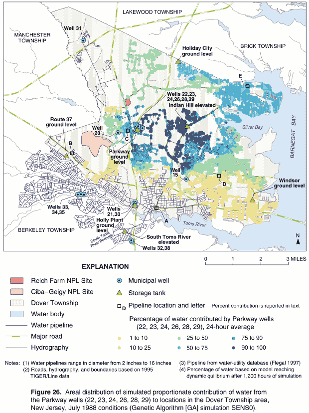
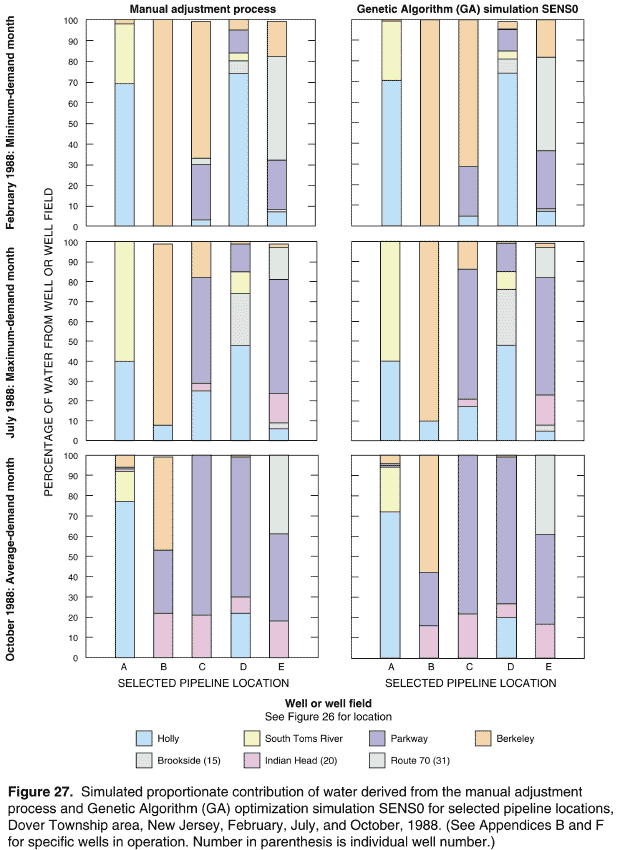
Table 22. Presentation of proportionate contribution results for wells and well fields for selected pipeline locations using sensitivity analyses SENS0, year, month of analysis, and location in report
[see Figure 26 or Plates 52–153 for pipeline locations; —, simulation results not presented in a graphical format for this month]
Simulation Month1 |
|||||||||||
|---|---|---|---|---|---|---|---|---|---|---|---|
January |
February |
March |
April |
May |
June |
July |
August |
September |
October |
November |
December |
|
|||||||||||
1962 |
|||||||||||
2Table I-1 |
Table I-1 |
Table I-1 |
Table I-1 |
Table I-1 |
Table I-1 |
Table I-1 |
Table I-1 |
Table I-1 |
Table I-1 |
Table I-1 |
Table I-1 |
— |
2Figure J-1 |
— |
— |
Figure J-1 |
— |
— |
— |
— |
Figure J-1 |
— |
— |
1965 |
|||||||||||
Table I-2 |
Table I-2 |
Table I-2 |
Table I-2 |
Table I-2 |
Table I-2 |
Table I-2 |
Table I-2 |
Table I-2 |
Table I-2 |
Table I-2 |
Table I-2 |
— |
Figure J-2 |
— |
— |
— |
Figure J-2 |
— |
— |
— |
Figure J-2 |
— |
— |
1971 |
|||||||||||
Table I-3 |
Table I-3 |
Table I-3 |
Table I-3 |
Table I-3 |
Table I-3 |
Table I-3 |
Table I-3 |
Table I-3 |
Table I-3 |
Table I-3 |
Table I-3 |
— |
Figure J-3 |
— |
— |
— |
— |
Figure J-3 |
— |
— |
Figure J-3 |
— |
— |
1978 |
|||||||||||
Table I-4 |
Table I-4 |
Table I-4 |
Table I-4 |
Table I-4 |
Table I-4 |
Table I-4 |
Table I-4 |
Table I-4 |
Table I-4 |
Table I-4 |
Table I-4 |
— |
Figure J-4 |
— |
— |
— |
Figure J-4 |
— |
— |
— |
Figure J-4 |
— |
— |
1988 |
|||||||||||
Table I-5 |
Table I-5 |
Table I-5 |
Table I-5 |
Table I-5 |
Table I-5 |
Table I-5 |
Table I-5 |
Table I-5 |
Table I-5 |
Table I-5 |
Table I-5 |
— |
Figure J-5 |
— |
— |
— |
— |
Figure J-5 |
— |
— |
Figure J-5 |
— |
— |
1995 |
|||||||||||
Table I-6 |
Table I-6 |
Table I-6 |
Table I-6 |
Table I-6 |
Table I-6 |
Table I-6 |
Table I-6 |
Table I-6 |
Table I-6 |
Table I-6 |
Table I-6 |
— |
Figure J-6 |
— |
— |
— |
— |
— |
Figure J-6 |
— |
Figure J-6 |
— |
— |
1996 |
|||||||||||
Table I-7 |
Table I-7 |
Table I-7 |
Table I-7 |
Table I-7 |
Table I-7 |
Table I-7 |
Table I-7 |
Table I-7 |
Table I-7 |
Table I-7 |
Table I-7 |
— |
Figure J-7 |
— |
— |
— |
Figure J-7 |
— |
— |
— |
Figure J-7 |
— |
— |
|
1February is minimum-demand month; October is average-demand month; May, June, July, or August are maximum-demand months. |
|||||||||||
As described previously, GA optimization methods were used to develop alternate operating schedules that also resulted in the successful operation of the historical water-distribution system. Pattern factors of operating schedules derived from the application of the GA methods, and used to schedule the operation of wells and supply nodes28 could be markedly different when compared to corresponding pattern factors derived using the manual adjustment process. An example of EPANET 2 pattern factors derived using the manual adjustment process and corresponding pattern factors from sensitivity analyses SENS0 are shown in Figure 28. The pattern factors schedule pumping at supply nodes representing Parkway wells 23 and 24, operating during July 1988. From Figure 28:
Although pattern factors for some hours of operation show marked differences (like those in Figure 28), the simulated proportionate contributions of water simulated using these different pattern factors for sensitivity analyses SENS0 show little difference throughout the Dover Township area when compared to corresponding proportionate contributions of water simulated using the manual adjustment process.
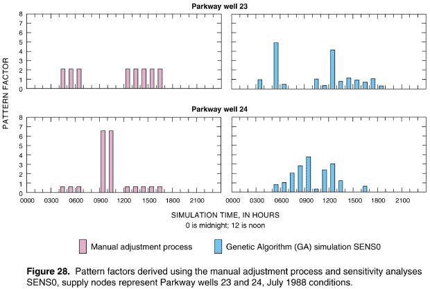
To assist in determining the differences between corresponding proportionate contribution results obtained using the manual adjustment process and sensitivity analyses SENS0, tabular values of the absolute value of these differences are provided in Appendix K (Tables K-1 through K-7). The differences between proportionate contribution results obtained using the manual adjustment process and corresponding results from sensitivity analyses SENS0 were computed according to the following:
DCi,j = difference in the proportionate contribution of water for the ith study location and the jth operating source (well or well field), in percent;
(Cmap)i,j = simulated proportionate contribution of water for the ith study location and the jth operating source (well or well field), obtained using the manual adjustment process, in percent;
(CGA0)i,j = simulated proportionate contribution of water for the ith study location and the jth operating source (well or well field), obtained from sensitivity analyses SENS0, in percent;
NSL = number of study locations; and
NS = number of operating sources of water (wells or well fields).
The absolute values of the differences were computed according to Equation (17) as follows:
where:
(DCi,j)abs = absolute value of difference computed using equation (16), in percent.
The tables in Appendix K list the absolute value of difference for each of the five pipeline locations (A–E) for every month of selected years 1962, 1965, 1971, 1978, 1988, 1995, and 1996.
In addition to sensitivity analyses SENS0, seven additional sensitivity analyses (SENS1–SENS7)—using GA optimization methods—were conducted to assess the effects of operating the historical water-distribution systems under alternate operating schedules and conditions (Tables 20 and 21). These sensitivity analyses were exhaustive with respect to the range of possible operating conditions for the representative historical networks (1962, 1965, 1971, 1978, 1988, and 1996). Examples of the resulting pattern factors from these sensitivity analyses are shown in Figures 29 and 30 for supply nodes representing Parkway wells 26 and 22, respectively.
Pattern factors derived from the manual adjustment process and corresponding factors from sensitivity analyses SENS1 are shown in Figure 29. Sensitivity analyses SENS1 were conducted to derive an alternate operating schedule that was not as optimal as the operating schedule derived from sensitivity analyses SENS0, but nonetheless resulted in a successful system operation that also honored the "Master Operating Criteria" (Table 20). The resulting pattern factors can be viewed in terms of seasonal variation by taking a certain year (for example, 1978, Figure 29) and comparing the results by moving vertically down the illustration from top to bottom. Historical variation is shown in Figure 29 by taking a certain demand condition (for example, average demand conditions occurring during the month of October) and comparing the results horizontally across the illustration from left to right.
Pattern factors derived using the manual adjustment process and corresponding pattern factors from all sensitivity analyses (SENS0–SENS7) are shown in Figure 30 for the supply node representing Parkway well 22. The pattern factors, derived for October 1996 demand conditions, show the effect of conducting the different sensitivity analyses with their respective constraints. For example, sensitivity analyses SENS3 were conducted to simulate the wells and high-service and booster pumps in either the "on" or the "off" position (Table 20). Therefore, the values of pattern factors were constrained to ranged between 0.75–1.25 for the "on" position or 0.0 for the "off" position. This constraint was in addition to the pressure and storage tank water-level constraints derived from the "Master Operating Criteria." As shown in Figure 30, the resulting pattern factors range between 0.75–1.25 for hours that the supply node is operational, and are 0.0 for simulation hours 0400 to 0500 and 1700 to 1900 when the supply node is not operational. The pattern factors resulting from all of the sensitivity analyses (Figure 30) also show some significant differences in terms of values and hours of operation when compared to the pattern factors derived using the manual adjustment process. However, regardless of the value or origin of the pattern factors derived using the sensitivity analyses, the simulated proportionate contributions of water when compared to corresponding results obtained using the manual adjustment process were highly similar.
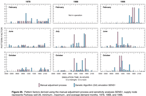
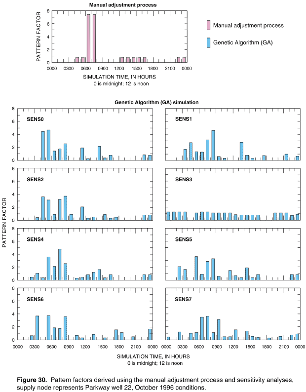
It is also possible to assess the results of each the sensitivity analyses (SENS0–SENS7) in terms of differences in the simulated proportionate contribution of water from wells and well fields to locations in the Dover Township area with respect to corresponding simulation results obtained from the manual adjustment process—as was demonstrated with sensitivity analyses SENS0. However, because of the large number of model nodes representing pipeline junctions in the historical networks, an alternate method of summarizing results would be preferable. An alternative presentation method that facilitates evaluation of the magnitude of the difference in the proportionate contribution of water between simulation methods and between the different sensitivity analyses was developed.
Differences in proportionate contributions derived from all sensitivity analyses (SENS0–SENS7) are shown in Figure 31. The graphs were constructed by using Equations (16) and (17) to compute the absolute value of the difference between simulated proportionate contribution results using the manual adjustment process and a particular sensitivity analysis simulation for all wells and well fields (sources) that contributed water to each study location.30 Then the percentage of study locations that exceeded a specified difference value was determined. The values of n in the graphs in Figure 31 represent the number of study locations where the contribution of water from a specified well or well field was greater than 0%. Figure 31 shows these results for minimum-, maximum-, and average-demand months of 1971, 1978, 1988, and 1996. Results shown on this figure can be used to assess the differences between simulated proportionate contributions of water to study locations derived using the manual adjustment process and each of the sensitivity analyses.
To determine the number of study locations receiving water from all operating wells and well fields where simulation results indicate a difference of 10% or less between results obtained using the manual adjustment process and sensitivity analyses SENS0 for 1978, the following procedure is used:
For this example, therefore, 97% is the percentage of study locations receiving water from all operating wells and well fields where the absolute difference in the simulated proportionate contribution of water between the manual adjustment process and sensitivity analyses SENS0 is 10% or less.
Alternatively, if information is desired on the difference between the manual adjustment process and the sensitivity analysis simulations for a specified percentage of study locations, then the procedure described above is reversed. For example, to determine the absolute difference in the simulated proportionate contributions of water between the manual adjustment process and sensitivity analyses SENS3 for 90% of study locations for the 1988 water-distribution system, the following procedure is used:
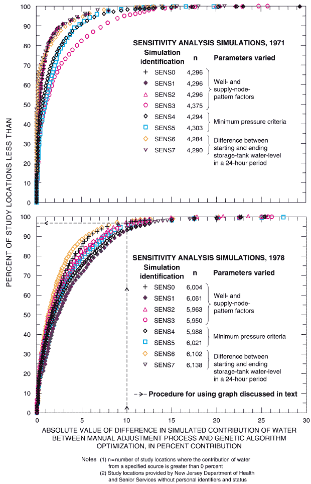
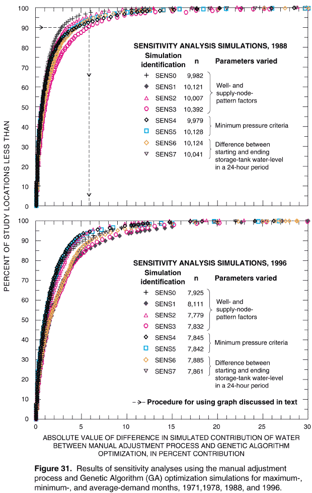
For this example (1988 and sensitivity analyses SENS3), the result is interpreted as indicating that, less than 10% of study locations (100%–90%), the absolute difference in the simulated proportionate contributions of water exceeds 5.7%. The absolute difference this example is derived using simulation results obtained from the manual adjustment process and corresponding results obtained from sensitivity analyses SENS3.
The procedures described above for evaluating the results of the sensitivity analyses and comparing them with the results from the manual adjustment process have to be repeated many tens or hundreds of times order to obtain an assessment of the overall range of differences in simulated proportionate contributions water for all sensitivity analyses. As an alternative, statistical analyses were conducted on these differences using results of the manual adjustment process as the bases of comparison. The statistical analyses assumed that the differences could be characterized by a normal distribution. Results of the statistical analyses are listed in Table 23 for all sensitivity analyses (SENS0–SENS7) for years 1962, 1965, 1971, 1978, 1988, and 1996. Table 23, values are listed for the following statistics:
Mathematical definitions for the statistics listed in Table 23 can be found in any standard text on mathematics, statistics, or probability (Beyer 1986), and therefore will not be presented in this report.
If the differences between the simulated proportionate contributions of water derived by the manual adjustment process and sensitivity analyses are normally distributed, then the computed values for the mean, mode, and median of the differences in the proportionate contribution of water should be equal. As can be seen from Table 23, the computed values for these statistics are nearly always 0%. The standard deviation of differences in percent contribution is generally below 5 %, with the exception of 1962, which was the earliest historical network analyzed and the network with the fewest number of pipelines and study locations (compare the n-value for the 1962 network with the n-value for the other historical networks listed in Table 23).
For a graphical representation of the statistical results listed in Table 23, histograms are shown in Figure 32 for all sensitivity analyses (SEN0–SEN7) for years 1971, 1978, 1988, and 1996. In these graphs, the bars of the histograms represent the differences in simulation results, computed using Equation (16), between the manual adjustment process and the sensitivity analyses. The histograms in Figure 32 are compared with a normal or Gaussian distribution that was fitted using the difference data. The results shown in Figure 32 confirm that, in general, the differences in the simulated proportionate contribution of water derived by comparing results of the manual adjustment process with the results obtained from the sensitivity analyses are normally distributed, and that the differences tend to have a narrow "spread" or deviation and cluster around a mean difference value of 0%.
The last column in Table 23 shows statistics computed for all eight of the GA sensitivity analyses (SENS0–SENS7) for each of the years listed in the table. These statistics can be interpreted as providing a quantitative evaluation for the differences in the proportionate contribution of water for any plausible operational mode (consistent with hydraulic engineering principles and the "Master Operating Criteria") for the historical water-distribution system characterized by the years listed in Table 23. For example, for the more recent historical networks (1988 and 1996), the different methods of simulating the successful operation of the water-distribution system would result in differences of proportionate contribution of water to locations in the Dover Township area of approximately 3% to 4% when compared with the manual adjustment process. These results are well within accepted limits for engineering and scientific analyses. For all sensitivity analyses for all of the years listed in Table 23, the mean, mode, and median of the differences are 0% and the standard deviation of the differences of proportionate contributions of water is 3.9%. Thus, for the entire historical period, which can be characterized by the six selected years listed in Table 23, sensitivity analyses indicated that the differences in the proportionate contribution of water—simulated by the range of operating conditions and hydraulic constraints previously described (Table 20)— are insensitive to the manner in which the water-distribution system was operated over a 24-hour period. Thus, the minor differences in the simulated proportionate contribution of water between the manual adjustment process and the sensitivity analyses (Figure 31) indicate that there was a narrow range of conditions within which the historical water-distribution system could have successfully operated to maintain a balanced flow condition and satisfy the "Master Operating Criteria."
Table 23. Statistical summary of differences in simulated proportionate contributions of water derived by the manual adjustment process and sensitivity analyses
[n, number of study locations where the contribution of water from a specified source (well or well field) is greater than 0%; DCm, mean of differences computed using difference using difference between contribution of water derived using the manual adjustment process and sensitivity analyses, in percent, see Equation (16) for definition of difference; DCo, mode of differences, in percent; DCd, median of differences; in percent; sDC, standard deviation of differences]
Year |
Statistic |
Sensitivity Analysis Simulation Identification1 |
||||||||
|---|---|---|---|---|---|---|---|---|---|---|
|
SENS0 |
SENS1 |
SENS2 |
SENS3 |
SENS4 |
SENS5 |
SENS6 |
SENS7 |
SENS0-SENS7 |
|
n |
948 |
953 |
948 |
948 |
948 |
948 |
948 |
948 |
7,589 |
|
DCm |
0.0 |
0.0 |
0.0 |
0.0 |
0.0 |
0.0 |
0.0 |
0.0 |
0.0 |
|
1962 |
DC0 |
0.0 |
0.0 |
0.0 |
0.0 |
0.0 |
0.0 |
0.0 |
0.0 |
0.0 |
DCd |
0.0 |
0.0 |
0.0 |
0.0 |
0.0 |
0.0 |
0.0 |
0.0 |
0.0 |
|
sDC |
6.7 |
9.5 |
7.4 |
5.9 |
7.0 |
9.4 |
6.2 |
5.7 |
7.3 |
|
n |
1,706 |
1,709 |
1,720 |
1,705 |
1,714 |
1,706 |
1,707 |
1,707 |
13,674 |
|
DCm |
0.0 |
0.0 |
0.0 |
0.0 |
0.0 |
0.0 |
0.0 |
0.0 |
0.0 |
|
1965 |
DC0 |
0.0 |
0.0 |
0.0 |
0.0 |
0.0 |
0.0 |
0.0 |
0.0 |
0.0 |
DCd |
0.0 |
0.0 |
0.0 |
0.0 |
0.0 |
0.0 |
0.0 |
0.0 |
0.0 |
|
sDC |
4.1 |
3.4 |
4.1 |
1.8 |
2.1 |
2.8 |
2.3 |
2.6 |
3.0 |
|
n |
4,296 |
4,296 |
4,296 |
4,375 |
4,294 |
4,303 |
4,284 |
4,290 |
34,434 |
|
DCm |
0.0 |
0.0 |
0.0 |
0.0 |
0.0 |
0.0 |
0.0 |
0.0 |
0.0 |
|
1971 |
DC0 |
0.0 |
0.0 |
0.0 |
0.0 |
0.0 |
0.0 |
0.0 |
0.0 |
0.0 |
DCd |
0.0 |
0.0 |
0.0 |
0.0 |
0.0 |
0.0 |
0.0 |
0.0 |
0.0 |
|
sDC |
2.6 |
2.6 |
2.6 |
4.3 |
3.3 |
2.9 |
2.2 |
2.2 |
2.9 |
|
n |
6,004 |
6,061 |
5,963 |
5,950 |
5,988 |
6,021 |
6,102 |
6,138 |
48,227 |
|
DCm |
0.0 |
0.0 |
0.0 |
0.0 |
0.0 |
0.0 |
0.0 |
0.0 |
0.0 |
|
1978 |
DC0 |
0.0 |
0.0 |
0.0 |
0.0 |
0.0 |
0.0 |
0.0 |
0.0 |
0.0 |
DCd |
-0.1 |
0.1 |
0.1 |
0.1 |
0.1 |
0.1 |
0.0 |
0.1 |
0.0 |
|
sDC |
3.9 |
5.6 |
4.1 |
4.5 |
5.1 |
4.8 |
3.7 |
5.3 |
4.7 |
|
n |
9,982 |
10,121 |
10,007 |
10,392 |
9,979 |
10,128 |
10,124 |
10,041 |
80,774 |
|
DCm |
0.0 |
0.0 |
0.0 |
0.0 |
0.0 |
0.0 |
0.0 |
0.0 |
0.0 |
|
1988 |
DC0 |
0.0 |
0.0 |
0.0 |
0.0 |
0.0 |
0.0 |
0.0 |
0.0 |
0.0 |
DCd |
0.1 |
0.0 |
0.0 |
0.0 |
0.0 |
0.1 |
0.1 |
0.1 |
0.0 |
|
sDC |
2.2 |
3.2 |
2.5 |
4.2 |
3.4 |
3.3 |
3.3 |
3.1 |
3.2 |
|
n |
7,925 |
8,111 |
7,779 |
7,832 |
7,845 |
7,842 |
7,885 |
7,861 |
63,080 |
|
DCm |
0.0 |
0.0 |
0.0 |
0.0 |
0.0 |
0.0 |
0.0 |
0.0 |
0.0 |
|
1996 |
DC0 |
0.0 |
0.0 |
0.0 |
0.1 |
0.0 |
0.0 |
0.0 |
0.0 |
0.0 |
DCd |
0.0 |
-0.1 |
0.0 |
0.1 |
0.0 |
0.0 |
0.0 |
0.0 |
0.0 |
|
sDC |
3.6 |
5.0 |
3.0 |
4.9 |
3.1 |
3.4 |
4.1 |
4.1 |
4.0 |
|
1See Table 20 for definitions of sensitivity analysis simulation identifications. |
||||||||||
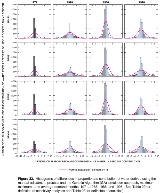
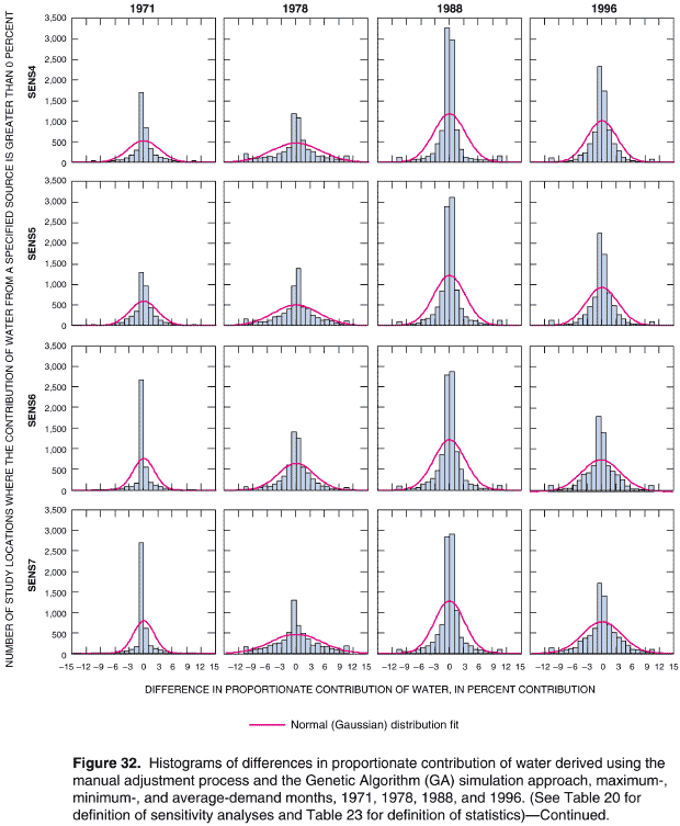
Daily System Operations Simulations
For the historical reconstruction analysis, daily system operations over a period of one month were represented by a "typical" 24-hour day for each month of the historical period. This approach was the basis for conducting the simulations using the manual adjustment process and sensitivity analyses SENS0–SENS7. Daily operational variations including routine maintenance of system facilities, repair of pipeline breaks, emergency fire service, and other temporary interruptions of routine operations over a "typical" 24-hour period were considered insignificant using this approach. To test the validity of this approach, additional sensitivity analyses (SENS8) were conducted using hourly operational data obtained from the water utility for 1996 (Tables 20 and 21). Pattern factors used in these simulations represented actual on-and-off cycling of wells and high-service and booster pumps. The "Master Operating Criteria" (Table 4) were also honored. Simulations were conducted using the manual adjustment process for the minimum-, maximum-, and average-demand months of February, June, and October 1996, respectively. For each of these months, simulation time corresponded to the number of hours in the month—696 hours (29 days) for February, 720 hours (30 days) for June, and 744 hours (31 days) for October.
Results of the month-long simulations for February, June, and October are shown in Figure 33 using the "stacked" column graph format for the five selected pipeline locations (A–E) previously identified. Comparison of these simulation results to corresponding results obtained using the "typical" 24-hour day simulation for each respective month, indicate similar values of simulated proportionate contribution were obtained. For example, simulation results for the maximum-demand month of June indicate that differences in the proportionate contribution of water from the Parkway well field for the two methods of simulating daily system operations were 0% for location A, 1% for location B, 4% for location C, 2% for location D, and 3% for location E. Therefore, sensitivity analyses SENS8 assisted in confirming that the day-to-day operations of the waterdistribution system were highly consistent over a month-long period (based on available 1996 hourly data) and could be realistically represented by a "typical" 24-hour operational pattern.
The sensitivity analyses conducted as part of the historical reconstruction of the water-distribution system serving the Dover Township area indicate that: (1) only a narrow range of conditions existed within which the historical water-distribution system could have successfully operated and still satisfy hydraulic engineering principles and the "Master Operating Criteria" (Table 4), and (2) daily operational variations over a month did not appreciably change the simulated proportionate contribution of water from specific sources when compared to results from a typical 24-hour day pattern of operation representing the month. Thus, the reconstructed historical water-distribution systems and operating criteria—based on applying the "Master Operating Criteria" and using generalized water-utility information—are believed to be the most plausible and realistic scenarios under which the historical water-distribution systems were operated.
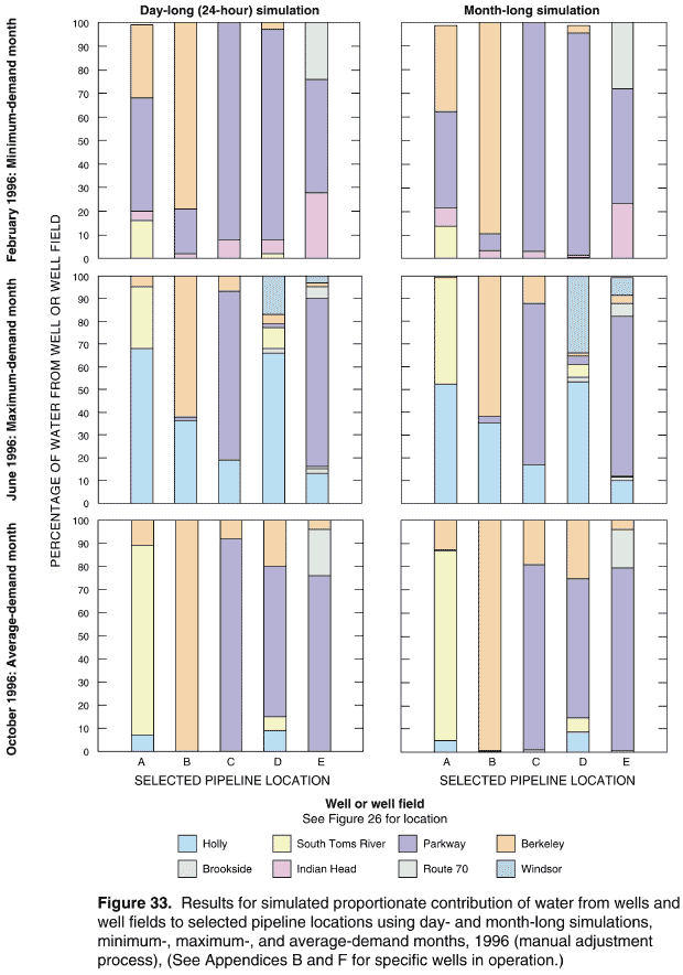
Contamination of groundwater resources in Dover Township, Ocean County, New Jersey (Figure 1), including the contamination of water-supply wells, was identified in the 1960s (Toms River Chemical Corporation 1966) and subsequently documented in the 1970s (ATSDR 2001a,b,c,d). Water-quality analyses, conducted since the mid-1980s, indicate this contamination has generally consisted of volatile organic compounds such as trichloroethylene and semi-volatile organic compounds such as styrene-acrylonitrile trimer (ATSDR 2001d). Based on public health assessments conducted for the Dover Township area, ATSDR and NJDHSS have determined that completed human exposure pathways to groundwater contaminants have occurred through private and community water supplies (ATSDR 2001a,b,c,d). As a result, NJDHSS and ATSDR are conducting an epidemiologic study of childhood leukemia and nervous system cancers that occurred in Dover Township. The epidemiologic study is exploring a variety of possible risk factors, including environmental exposures. To assist NJDHSS with the environmental exposure assessment component of the epidemiologic study, ATSDR developed a water-distribution model using the EPANET 2 software. Results obtained from the model will be used to assess exposure to drinking water sources that are being investigated as potential risk factors in the epidemiologic investigation.
Because of the lack of appropriate historical data, the EPANET 2 model was calibrated to the present-day (1998) water-distribution system characteristics using data collected during March and August 1998. The reliability of the calibrated model was demonstrated by successfully conducting a water-quality simulation of the transport of a naturally occurring conservative element—barium—and comparing results with data collected at 21 schools and 6 points of entry to the waterdistribution system during March and April 1996. Results of the field-data collection activities, model calibration, and reliability testing were described previously (Maslia et al. 2000a,b). Following calibration, the model was used to simulate historical characteristics of the water-distribution system serving the Dover Township area from 1962 through 1996.
This report describes the historical reconstruction analysis of the water-distribution system serving the Dover Township area. It is viewed as a companion document to Maslia et al. (2000a) which describes the analysis of the 1998 water-distribution system. Therefore, the report focuses on these aspects of the historical reconstruction analysis: (1) data sources and requirements, (2) methods of analysis, (3) simulation strategies, (4) selected simulation results, and (5) the use of sensitivity analysis to address issues of uncertainty and variability of historical system operations.
Given the paucity of historical contaminant-specific concentration data during most of the period relevant to the epidemiologic study, ATSDR and NJDHSS decided that modeling efforts should concentrate on estimating the percentage of water that a study subject might have received from each point of entry (well or well field) to the water-distribution system (Plates 3–37). This approach uses the concept of "proportionate contribution" described in Maslia et al. (2000a, p. 4) wherein at any given point in the distribution system, water may be derived from one or more sources in differing proportions.
Databases were developed from diverse sources of information and were used to describe the historical distribution- system networks specific to the Dover Township area. These data were applied to EPANET 2 and simulations were conducted for each month of the historical period—January 1962 through December 1996 (420 simulations or "model runs"). After completing the 420 monthly analyses, source-trace analysis simulations were conducted to determine the percentage of water contributed by each well or well field operating during each month. Results of these analyses—the percentage of water derived from the different sources that historically supplied the water-distribution system—were provided to health scientists for their analysis in assessing the environmental factors being considered by the epidemiologic investigation.
A simulation approach to the historical reconstruction of the water-distribution system in the Dover Township area required knowledge of the functional as well as the physical characteristics of the distribution system. Accordingly, six specific types of information were required: (1) pipeline and network configurations for the distribution system; (2) potable water-production data including information on the location, capacity, and time of operation of the groundwater production wells; (3) consumption at locations throughout the distribution system; (4) storage-tank capacities, elevations, and water-level data; (5) high-service and booster pump characteristic curves; and (6) system-operations information such as the on-and-off cycling schedule of wells and high-service and booster pumps, and the operational extremes of water levels in storage tanks.
Yearly historical network configurations maps the period 1962 through 1996 are presented on Plates through 37. These maps show the complexity of the system increased significantly over the time span of the historical period. For example, the 1962 water-distribution system served nearly 4,300 customers from a population of about 17,200 persons (Board of Public Utilities, State of New Jersey 1962) and was characterized for modeling by (Plate 3):
By contrast, in 1996—the last year of the historical reconstruction period—the water-distribution system served nearly 44,000 customers from a population about 89,300 persons (Board of Public Utilities, State New Jersey 1996) and was characterized for modeling by (Plate 37):
Analysis of production data indicates that the historical distribution systems could be characterized by three typical demand periods each year: (1) a low- or winter-demand period, generally represented by the month of February—designated as the minimumdemand month; (2) a peak- or summer-demand period, represented by one of the months of May, June, July, or August—designated as the maximum-demand month; and (3) an average-demand period, generally-represented by the month of October—designated as the average-demand month.
Water-production data were gathered, aggregated, and analyzed for each well for every month of the historical period (Appendix B). These data were obtained from the water utility (Flegal 1997), the annual reports of the Board of Public Utilities, State of New Jersey (1962–1996), and NJDHSS data searches (Michael P. McLinden, written communication, August 28, 1997). The production data were measured by using in-line flow meters at water-supply wells (George J. Flegal, Manager, United Water Toms River, Inc., oral communication, August 28, 2001).
Monthly production data were represented graphically in a three-dimensional plot (Figure 12). Referring to this plot, the x-axis is the year (1962–96), the y-axis is the month (January–December), and the z-axis is the total monthly production in million gallons. Maximum production is shown to occur in the months of May, June, July, or August. In addition, considerable production increases occurred in 1971, 1988, and 1995. These years are characterized on the plot by sharp peaks.
To simulate the distribution of water for each of the 420 months of the historical period, network configuration, consumption, and operational information were required. Before 1978, operational data were unavailable requiring development of system-operation parameters —designated as "Master Operating Criteria" (Table 4). These are based on hydraulic engineering principles necessary to successfully operate distribution systems similar to the one serving the Dover Township area. From 1978 forward, for selected years, operators of the water utility provided information on the generalized operating practices for a typical "peak-demand" (summer) and "non-peak demand" (fall) day. These guidelines were used in conjunction with the "Master Operating Criteria" to simulate a typical 24-hour daily operation of the water-distribution system for each month of the historical period.
Examples of historical water-distribution system operating schedules for the minimum-, maximum-, average-demand months of 1962, 1965, 1971,1978, 1988, 1995, and 1996 are presented in Appendix (Tables D-1 through D-7). These tables indicate hour-by-hour operation of wells and high-service booster pumps during a typical day of the minimum-, maximum-, and average-demand month for the given year. In 1962 and 1965 (Tables D-1 and D-2, respectively), high-service and booster pumps were not part the distribution system and, therefore, only groundwater wells were operated to supply demand by discharging water directly into the distribution system. In 1968, high-service and booster pumps were added to the distribution system. From that year forward, some wells supplied storage tanks, then high-service and booster pumps were operated to meet distribution-system demands; other wells still discharged directly into distribution system (refer to Tables D-1 through D-7 Appendix D for details).
In this type of study, the ideal or desired condition is to obtain all data required for model simulations through direct measurement or observation. In reality, however, necessary data are not routinely available direct measurement or observation and must be synthesized using generally accepted engineering analyses methods. Issues of data sources and the methods used obtain data that cannot be directly measured reflect, ultimately, on the credibility of simulation results. address these issues for historical reconstruction analysis, the methods for obtaining the necessary data were grouped into three categories (Table 12):
Of the six specific types of information required for the historical reconstruction analysis, the network pipeline data, groundwater well-location data, groundwater well-production data, and storage-tank data were obtained by direct measurement or observation. These data were available throughout the entire historical period and they could be assessed for quality and verified by independent means such as state reports or field observations. For example, groundwater well-production data were available for every well for every month of the historical period and these data were measured by the water utility using in-line flow-metering devices at groundwater wells (George J. Flegal, Manager, United Water Toms River, Inc., oral communication, August 28, 2001).
Data for historical consumption consisted of two components—monthly volumes (quantity) and spatial distribution (location). The monthly volumes were obtained by using a quantitative estimation method. Data were available from metered billing records for October 1997 through April 1998 and verified through the calibration process described in Maslia et al. (2000a,b); the magnitude of monthly historical production was known based on measured flow data. Using these data, estimates of historical consumption were quantified by imposing the requirement that total consumption must equal total production.
Direct measurement or quantitative estimates of the spatial distribution of historical point- demand data (demands at specific pipeline locations) were not available for the Dover Township area. Therefore, qualitative description methods were used to estimate historical data values. In doing so, estimates of the spatial distribution of historical point-demand data were based on two assumptions: (1) historical demand patterns were similar to the present-day demand patterns which are known from available metered billing records; and (2) demand patterns could be inferred from land-use classification using historical land-use classification as a surrogate indicator. To assess the validity of this approach, historical land-use classification or zoning maps for Dover Township were used in conjunction with distribution-system network maps for 1962, 1967, 1978, 1990, and 1996 (network maps like the ones shown on Plates 3, 8, 19, 31, and 37, respectively). Using information obtained from the land-use classification and distribution-system network maps, geospatial and comparative analyses were conducted (Table 3). Results of these analyses indicated that the distribution of land-use classification in Dover Township was relatively static and changed little during the historical period. These analyses substantially validated the qualitative description method used to estimate the spatial distribution of historical demand.
The high-service and booster pump-characteristic data were derived using information obtained from the water utility (Flegal 1997). This information consisted of head values versus flow values which were refined during the model calibration process (Maslia et al. 2000a,b).
The historical system-operation data were obtained using each of the three methods of obtaining data described previously—depending on the time frame (Table 12). For the early historical period (1962–77), investigators relied on hydraulic engineering principles and the "Master Operating Criteria" (Table 4). Because data describing specific operational practices were not available, operating schedules developed for these early historical networks were based on qualitative descriptions of system operations. To maintain a balanced flow condition, however, water-distribution systems of similar configuration and facilities as the historical Dover Township area system generally operate using on-andoff cycling schedules of limited variability. That is, wells and high-service and booster pumps must be cycled on-and-off within a limited or narrow operating range. Simulations conducted on the water-distribution system serving the Dover Township area confirmed the limited variability of the on-and-off cycling operating schedule.
For the 1977–1987 period, system-operation data were developed from quantitative estimates and qualitative descriptions of the operating schedules. These data were derived using hydraulic engineering principles, the "Master Operating Criteria," and from information provided by the water utility that described the general operations of the water-distribution system for a typical "peak" day (summer) and a "non-peak" (fall) day. For some of the years, the water utility also provided estimates of discharge to the distribution system from the high-service and booster pumps (Richard Ottens, Jr., Production Manager, United Water Toms River, Inc., written communication, 1998).
System-operation data for the most recent historical systems (1988–96) were obtained from direct measurement or observation, quantitative estimates, and qualitative descriptions of operating schedules. Data sources used to develop these operating schedules (for example, Tables D-6 and D-7) included the generalized operating notes from the water utility (Richard Ottens, Jr., Production Manager, United Water Toms River, Inc., written communication, 1998), hourly operations data for 1996 (Flegal 1997), notes taken by ATSDR and NJDHSS staff during field-data collection activities in March and April 1998 (Maslia et al. 2000a), and the observation that the distribution system had previously operated in a manner very similar to the present-day system (1998), for which detailed information was available.
Simulation of water-distribution networks require detailed descriptions of network operations, such as the on-and-off scheduling of high-service and booster pumps and groundwater wells for the entire period of simulation. In order to simplify these rigorous data requirements, a surrogate or alternative method—designated the "source-node-link" or SNL simulation method (Figure 19)—was devised whereby balanced flow conditions were maintained and the measured volumes of monthly water production were used while avoiding the need for detailed network operations data, which were not available for most of the historical period. Comparison of flow results obtained using the surrogate SNL simulation method with measured flow data obtained during August 1998 for the Holly and Parkway treatment plants showed that the SNL method simulated nearly identical flows to those measured (Figure 20 and Table 16).
Analysis of the proportionate contribution of water from wells and well fields to selected network locations in the Dover Township area illustrates the increasing complexity and operational variability of the distribution system throughout the historical period. These results were obtained by conducting source-trace analysis simulations. Results are presented as areal distributions of the simulated proportionate contribution water from active wells or well fields to all locations serviced by the water-distribution system for selected years 1962, 1965, 1971, 1978, 1988, 1995, and 1996 (minimum-, maximum-, and average-demand months; Plates 52–153). The annual variation of the simulated proportionate contribution of water from operating wells and well fields to selected locations in the Dover Township area is shown for the minimum-demand month of February (Figure 23), the maximum-demand months May, June, July, or August (Figure 24), and the average-demand month of October (Figure 25). For each of these examples, five geographically distinct pipeline locations were selected from the historical networks to represent the spatial distribution of proportionate contribution results. These locations are identified as locations A, C, D, and E.
Comparison of the May 1962 results with the June 1996 results (Figure 24), indicates the increasing complexity of the network and distribution-system operations and how such operations influenced the proportionate contribution of water to specific locations. In May 1962, only two well fields (Holly and Brookside) provided water to any one location; whereas, June 1996, as many as seven well fields provided water to the distribution system (for example, pipeline location E in Figure 24).
Simulation results for the maximum-demand months of May 1962, July 1971, June 1978, July 1988, August 1995, and June 1996 for pipeline location exemplify the annual variation in the contribution water to this location and indicate the following (Figure 24):
The simulation results shown in Figures 23 through 25 demonstrate that the contribution of water from wells and well fields varied by time and location. However, the results also show that certain wells provided the predominant amount of water to locations throughout the Dover Township area. The proportionate contribution of water from specific water sources at specified times during the historical period of 1962 through 1996 are provided on Plates 52 through 153.
The proportionate contribution results described above were obtained from trace-analysis simulations conducted on the historical distribution-system networks whereby balanced flow conditions were achieved through the manual refinement of modeling parameters. The adjusted parameters were the on-and-off cycling pattern values (pattern factor values assigned in EPANET 2) of wells and supply nodes representing wells linked to storage tanks and high-service and booster pumps and the operational extremes of water levels in the storage tanks. This modeling approach was designated as the "manual adjustment process." Simulation results presented in Figures 23–25, on Plates 52–153, and in Appendices H and I were obtained using the manual adjustment process and were the bases of comparisons for all sensitivity analyses.
To address the issue of uncertainty and variability of system operations, and specifically to test the sensitivity of the proportionate contribution results to variations in model-parameter values, a technique was required that would "search" for and select a set of alternate operating conditions different from those determined using the manual adjustment process. These alternate operating conditions needed also to result in the satisfactory operation of the historical water-distribution system. Such a technique was found in the Genetic Algorithm optimization (GA) method which refers to a method of optimization that attempts to find the most optimal solution by mimicking (in a computational sense) the mechanics of natural selection and natural genetics. (Details of the methodology and the application of the method to water-distribution system operations is presented in Appendix E.)
Four types of operational and hydraulic constraints were varied during sensitivity analyses in order to determine the effects of constraint changes on the simulated proportionate contribution results. The constraints subjected to variations were (Table 20): (1) pattern factors assigned to wells and supply nodes—designated as sensitivity simulations SENS0, SENS1, SENS2, and SENS3; (2) minimum pressure requirements at model nodes—designated as sensitivity simulations SENS4 and SENS5; (3) allowable storage tank water-level differences between the starting time (0 hours) and ending time (24 hours) of a simulation—designated as sensitivity simulations SENS6 and SENS7; and (4) daily system operations represented by a "typical" 24-hour day over a month-long period—designated sensitivity simulation SENS8. For the first three types of constraints (SENS0–SENS7), the GA optimization methods were used to obtain simulation results for the proportionate contribution of water at all pipeline locations, and, these results were compared with results previously obtained using the manual adjustment process. For the fourth type of constraint variation (SENS8), the manual adjustment process was used to obtain simulation results for the sensitivity analysis. Descriptions of parameter variations for the sensitivity analyses are listed in Table 20 and the simulation month and year are listed in Table 21.
Results for the sensitivity analysis simulations using the GA methods representing 1962, 1965, 1971, 1978, 1988, 1995, and 1996 conditions are presented in Appendix I (Tables I-1 through I-7) and Appendix J (Figures J-1 through J-7). Analysis of these results indicate small variations when comparing the proportionate contribution results from the manual adjustment process to results obtained using the GA methods (Figure 27). Furthermore, analyses of differences in the simulation results (Appendix K and Figure 31) show that the simulated proportionate contribution of water from wells and well fields is relatively insensitive to changes in system operational parameters. For a 24-hour period, the average percentage of water over all study locations derived from all wells or well fields using either the manual adjustment process or any of the GA methods does not vary appreciably. Statistical analyses of the differences in simulated proportional contribution results obtained using the manual adjustment process and GA methods showed that differences are normally distributed for study locations characterized by the six selected historical networks for years 1962, 1965, 1971, 1978, 1988, and 1996 (Figure 32). These analyses further indicated that, overall, the difference distributions were characterized by a mean, mode, and median of nearly 0% and a standard deviation of less than 4% (Table 23). The sensitivity analyses indicated that the differences in the proportionated contribution of water—simulated by the exhaustive range of operating conditions and hydraulic constraints (Table 20)—are insensitive to the manner in which the water-distribution system was operated over a 24-hour period. As a consequence, the minor differences in the simulated proportionate contribution of water between the manual adjustment process and the GA simulation approach indicate that there was a narrow range within which the historical water-distribution system could have successfully operated to maintain a balanced flow condition and satisfy the "Master Operating Criteria."
For the historical reconstruction analysis, investigators assumed that daily system operations over a period of one month could be represented by a "typical" 24- hour day for each month of the historical period. To test the validity of this assumption, additional sensitivity analyses (SENS8) using hourly operational data obtained from the water utility were conducted. Monthlong simulations were conducted for February, June, and October which represented, respectively, the minimum-, maximum-, and average-demand months for 1996. Simulations were conducted using the manual adjustment process according to the hourly operational data for 1996 supplied by the water utility. When results for the month-long simulations (averages over the month-long period) were compared with results from the "typical" 24-hour day, differences in the proportionate contribution of water to the five pipeline locations (A–E) showed only slight variations (Figure 33). As an example, for June 1996, the difference in the contribution of water from the Parkway well field for the two methods of simulating the daily system operations were 0% for location A, 1% for location B, 4% for location C, 2% for location D, and 3% for location E. Therefore, sensitivity analysis assisted in confirming that the day-to-day operations of the water-distribution system were highly consistent over a month-long period (based on available 1996 hourly data) and could be represented by a "typical" 24-hour operational pattern.
The sensitivity analyses conducted as part of the historical reconstruction of the water-distribution system serving the Dover Township area indicate that: (1) there was a narrow range within which the historical water-distribution systems could have successfully operated and still satisfy hydraulic engineering principles and the "Master Operating Criteria," and (2) daily operational variations over a month did not appreciably change the proportionate contribution of water from specific sources when compared to a typical 24-hour day representing the month.
Overall, the simulation results for the proportionate contribution of water from wells and wells fields indicate variation by time and location. However, the results also show that certain wells provided the predominant amount of water to locations throughout the Dover Township area. In summary, therefore, the reconstructed historical water-distribution systems and operating criteria—based on applying the "Master Operating Criteria" and using generalized water-utility information—are believed to be plausible and realistic scenarios under which the historical 1962–96 water-distribution system was operated.
AVAILABILITY OF MODEL INPUT DATA AND PROPORTIONATE CONTRIBUTION RESULTS FILES
EPANET 2 compatible input data sets developed to conduct the monthly historical simulations for January 1962–December 1996, using the manual adjustment process, are provided with this report in a computer disc-read only memory (CD-ROM) format. The CD-ROMs contain the INP file formats described in the EPANET 2 Users Manual. Additionally, each CD-ROM contains a fully executable copy of the public-domain EPANET 2 water-distribution system model (Version 2.0, Build 2.00.08) that was used to conduct the historical monthly simulations, and the EPANET 2 Users Manual.
Also included on the CD-ROMs are data files that contain digital (electronic) results shown on Plates 52 through 153. These data files contain the nodal values of simulated proportionate contribution of water from each operating well or well field to all water-distribution system pipeline locations—obtained using the manual adjustment process—for the minimum-, maximum-, and average-demand months for seven selected years 1962, 1965, 1971, 1978, 1988, 1995, and 1996. The files are prepared in "text," "Excel," and "DBF" formats.
Readers desiring information about the model input data files or the proportionate contribution result data files contained on the CD-ROMs may also contact the senior author of the report at the following address:
Morris L. Maslia, P.E.
Agency for Toxic Substances and Disease Registry
1600 Clifton Road, Mail Stop E-32
Atlanta, Georgia 30333
Telephone: (404) 498-0415
Facsimile: (404) 498-0069
E-mail: mmaslia@cdc.gov
ACKNOWLEDGMENTS
The authors acknowledge their colleagues at ATSDR for providing assistance and advice with all aspects of this investigation: John E. Abraham, Patrick Brady, James A. Clark, Amy B. Funk, Amanda J. Gonzalez, Virginia Lee, Susan Metcalf, Thomas A. Mignone, Jennifer Noack, Mary G. Odom, Sven E. Rodenbeck, Kevin A. Ryan, Kathy Skipper, Allan S. Susten, Gregory V. Ulirsch, and Ann Walker.
The following organizations and their staff provided suggestions, assistance, or information: New Jersey Department of Health and Senior Services (NJDHSS); Ocean County Health Department; Dover Township Municipal Government; Citizens Action Committee on Childhood Cancer Cluster; Multimedia Environmental Simulations Laboratory at the Georgia Institute of Technology; New Jersey Department of Environmental Protection; New Jersey Geological Survey; U.S. Environmental Protection Agency, Region II; U.S. Geological Survey; United Water Toms River, Inc.; Union Carbide Corporation; and Ciba-Geigy Corporation.
The authors would like to specifically acknowledge Jerald A. Fagliano, Michael Berry, and Jonathan E. Savrin of NJDHSS for suggestions and advice from the epidemiologic perspective; Michael J. McLinden, formerly with NJDHSS, for assistance in obtaining historical production data; Lewis A. Rossman, U.S. Environmental Protection Agency, National Risk Management Research Laboratory, for assistance with and requested modifications to the EPANET 2 water-distribution system model; S. Jack Alhadeff and Thomas R. Dyar, U.S. Geological Survey, Center for Spatial Analysis Technologies, for assistance with preparing historical aerial photographs; and Robert E. Faye, for assistance with data collection and computer simulation.
The authors also acknowledge Steven G. Buchberger, Donald V. Chase, Robert E. Faye, Walter Grayman, Frederick Hart, Lewis A. Rossman, and James G. Uber for providing review of the this report. Naida Gavrelis, Eastern Research Group, Inc., provided logistical support in coordinating review of the report.
Carolyn A. Casteel, Caryl J. Wipperfurth, and Bonnie J. Turcott, U.S. Geological Survey, Atlanta, Georgia, assisted with the preparation of text and illustrations for final printing.
Agency for Toxic Substances and Disease Registry (ATSDR). 1988. Public health assessment for Ceiba-Geigy corporation, Dover Township, Ocean County, New Jersey. CERCLIS no. NJD001502517. Atlanta: U.S. Department of Health and Human Services.
Agency for Toxic Substances and Disease Registry (ATSDR). 1989. Public health assessment for Reich Farms, Dover Township, Ocean County, New Jersey. CERCLIS no. NJD980529713. Atlanta: U.S. Department of Health and Human Services.
Agency for Toxic Substances and Disease Registry (ATSDR). 1999. Expert review of Toms River, New Jersey, water distribution model, meeting summary report. Atlanta: Agency for Toxic Substances and Disease Registry.
Agency for Toxic Substances and Disease Registry (ATSDR). 2001a. Health consultation, drinking water quality analyses, March 1996 to June 1999, United Water Toms River, Dover Township, Ocean County, New Jersey. Atlanta: Agency for Toxic Substances and Disease Registry.
Agency for Toxic Substances and Disease Registry (ATSDR). 2001b. Public health assessment for Ceiba-Geigy Corporation, Dover Township, Ocean County, New Jersey, EPA facility ID: NJD001502517. Atlanta: Agency for Toxic Substances and Disease Registry.
Agency for Toxic Substances and Disease Registry (ATSDR). 2001c. Public health assessment for Dover Township Municipal Landfill (a/k/a Dover Township Landfill), EPA facility ID: NJD980771570 and Silverton private well contamination investigation (a/k/a Silverton wells), EPA facility ID: NJD981877780, Dover Township, Ocean County, New Jersey. Atlanta: Agency for Toxic Substances and Disease Registry.
Agency for Toxic Substances and Disease Registry (ATSDR). 2001d. Public health assessment for Reich Farm, Dover Township, Ocean County, New Jersey, EPA facility ID: NJD980529713. Atlanta: Agency for Toxic Substances and Disease Registry.
Agency for Toxic Substances and Disease Registry (ATSDR). 2001e. Summary report, expert panel meeting evaluating ATSDR’s Dover Township water-distribution system model: historical reconstruction analysis, November 14, 2000. Atlanta: Agency for Toxic Substances and Disease Registry.
Agency for Toxic Substances and Disease Registry (ATSDR). 2001f. Summary of findings, historical reconstruction of the water-distribution system serving the Dover township area, New Jersey: January 1962–December 1996, September 2001. Atlanta: Agency for Toxic Substances and Disease Registry.
Aral MM, Guan J, Maslia ML. 2001a. Identification of contaminant source location and release history in aquifers. J Hydrologic Engineering 6(3):225–34.
Aral MM, Guan J, Maslia ML, and Sautner JB. 2001b. Reconstruction of hydraulic management of a water-distribution system using genetic algorithms. Multimedia Environmental Simulations Laboratory Report No. MESL-01-01. Atlanta: School of Civil and Environmental Engineering, Georgia Institute of Technology.
Aral MM, Guan J, Maslia ML, Lio B, Sautner JB, Williams RC, and Reyes JJ. 2001c. Reconstruction of hydraulic management of a water distribution system using genetic algorithms. In: [CD-ROM] World Water and Environmental Resources Congress 2001, Environmental and Water Resources of the American Society of Civil Engineers. Orlando: May 20-24, 2001.
Bhave PR. 1991. Analysis of flow in water distribution systems. Lancaster, PA: Technomic Publishing Company.
Berry M, Haltmeier P. 1997. Childhood cancer incidence health consultation: A review and analysis of cancer registry data, 1979–1995 for Dover Township (Ocean County), New Jersey, final technical report. Trenton (NJ): New Jersey Department of Health and Senior Services, Division of Environmental and Occupational Health Services, Consumer and Environmental Health Services.
Beyer WH, editor. 1986. CFC standard mathematical tables. 27th ed. Boca Raton (FL): CRC Press, Inc.
Board of Public Utilities, State of New Jersey. 1962. Annual report of Toms River Water Company, year ended December 31, 1962. Newark (NJ): Board of Public Utilities.
Board of Public Utilities, State of New Jersey. 1963. Annual report of Toms River Water Company, year ended December 31, 1963. Newark (NJ): Board of Public Utilities.
Board of Public Utilities, State of New Jersey. 1964. Annual report of Toms River Water Company, year ended December 31, 1964. Newark (NJ): Board of Public Utilities.
Board of Public Utilities, State of New Jersey. 1965. Annual report of Toms River Water Company, year ended December 31, 1965. Newark (NJ): Board of Public Utilities.
Board of Public Utilities, State of New Jersey. 1966. Annual report of Toms River Water Company, year ended December 31, 1966. Newark (NJ): Board of Public Utilities.
Board of Public Utilities, State of New Jersey. 1967. Annual report of Toms River Water Company, year ended December 31, 1967. Newark (NJ): Board of Public Utilities.
Board of Public Utilities, State of New Jersey. 1968. Annual report of Toms River Water Company, year ended December 31, 1968. Newark (NJ): Board of Public Utilities.
Board of Public Utilities, State of New Jersey. 1969. Annual report of Toms River Water Company, year ended December 31, 1969. Newark (NJ): Board of Public Utilities.
Board of Public Utilities, State of New Jersey. 1970. Annual report of Toms River Water Company, year ended December 31, 1970. Newark (NJ): Board of Public Utilities.
Board of Public Utilities, State of New Jersey. 1971. Annual report of Toms River Water Company, year ended December 31, 1971. Newark (NJ): Board of Public Utilities.
Board of Public Utilities, State of New Jersey. 1972. Annual report of Toms River Water Company, year ended December 31, 1972. Newark (NJ): Board of Public Utilities.
Board of Public Utilities, State of New Jersey. 1973. Annual report of Toms River Water Company, year ended December 31, 1973. Newark (NJ): Board of Public Utilities.
Board of Public Utilities, State of New Jersey. 1974. Annual report of Toms River Water Company, year ended December 31, 1974. Newark (NJ): Board of Public Utilities.
Board of Public Utilities, State of New Jersey. 1975. Annual report of Toms River Water Company, year ended December 31, 1975. Newark (NJ): Board of Public Utilities.
Board of Public Utilities, State of New Jersey. 1976. Annual report of Toms River Water Company, year ended December 31, 1976. Newark (NJ): Board of Public Utilities.
Board of Public Utilities, State of New Jersey. 1977. Annual report of Toms River Water Company, year ended December 31, 1977. Newark (NJ): Board of Public Utilities.
Board of Public Utilities, State of New Jersey. 1978. Annual report of Toms River Water Company, year ended December 31, 1978. Newark (NJ): Board of Public Utilities.
Board of Public Utilities, State of New Jersey. 1979. Annual report of Toms River Water Company, year ended December 31, 1979. Newark (NJ): Board of Public Utilities.
Board of Public Utilities, State of New Jersey. 1980. Annual report of Toms River Water Company, year ended December 31, 1980. Newark (NJ): Board of Public Utilities.
Board of Public Utilities, State of New Jersey. 1981. Annual report of Toms River Water Company, year ended December 31, 1981. Newark (NJ): Board of Public Utilities.
Board of Public Utilities, State of New Jersey. 1982. Annual report of Toms River Water Company, year ended December 31, 1982. Newark (NJ): Board of Public Utilities.
Board of Public Utilities, State of New Jersey. 1983. Annual report of Toms River Water Company, year ended December 31, 1983. Newark (NJ): Board of Public Utilities.
Board of Public Utilities, State of New Jersey. 1984. Annual report of Toms River Water Company, year ended December 31, 1984. Newark (NJ): Board of Public Utilities.
Board of Public Utilities, State of New Jersey. 1985. Annual report of Toms River Water Company, year ended December 31, 1985. Newark (NJ): Board of Public Utilities.
Board of Public Utilities, State of New Jersey. 1986. Annual report of Toms River Water Company, year ended December 31, 1986. Newark (NJ): Board of Public Utilities.
Board of Public Utilities, State of New Jersey. 1987. Annual report of Toms River Water Company, year ended December 31, 1987. Newark (NJ): Board of Public Utilities.
Board of Public Utilities, State of New Jersey. 1988. Annual report of Toms River Water Company, year ended December 31, 1988. Newark (NJ): Board of Public Utilities.
Board of Public Utilities, State of New Jersey. 1989. Annual report of Toms River Water Company, year ended December 31, 1989. Newark (NJ): Board of Public Utilities.
Board of Public Utilities, State of New Jersey. 1990. Annual report of Toms River Water Company, year ended December 31, 1990. Newark (NJ): Board of Public Utilities.
Board of Public Utilities, State of New Jersey. 1991. Annual report of Toms River Water Company, year ended December 31, 1991. Newark (NJ): Board of Public Utilities.
Board of Public Utilities, State of New Jersey. 1992. Annual report of Toms River Water Company, year ended December 31, 1992. Newark (NJ): Board of Public Utilities.
Board of Public Utilities, State of New Jersey. 1993. Annual report of Toms River Water Company, year ended December 31, 1993. Newark (NJ): Board of Public Utilities.
Board of Public Utilities, State of New Jersey. 1994. Annual report of Toms River Water Company, year ended December 31, 1994. Newark (NJ): Board of Public Utilities.
Board of Public Utilities, State of New Jersey. 1995. Annual report of United Water Toms River, year ended December 31, 1995. Newark (NJ): Board of Public Utilities.
Board of Public Utilities, State of New Jersey. 1996. Annual report of United Water Toms River, year ended December 31, 1996. Newark (NJ): Board of Public Utilities.
Board of Public Utilities, State of New Jersey. 1997. Annual report of United Water Toms River, year ended December 31, 1997. Newark (NJ): Board of Public Utilities.
Board of Public Utilities, State of New Jersey. 1998. Annual report of United Water Toms River, year ended December 31, 1998. Newark (NJ): Board of Public Utilities.
Clarke KC. 1999. Getting started with geographic information systems, second edition. New Jersey: Prentice-Hall, Inc.
Flegal GJ. 1997. United Water Toms River, Inc. Written communication to Morris L. Maslia. February 25, 1997.
Goldberg DE. 1989. Genetic algorithms in search, optimization, and machine learning. New York: Addison Wesley Longman, Inc.
Grayman, WM, Clark, RM, and Males, RM. 1988. Modeling distribution-system water quality: Dynamic approach. ASCE Journal of Water Resources Planning and Management 114(3):295-312.
Guan J, Aral MM. 1999a. Progressive genetic algorithm for solution optimization problems with nonlinear equality and inequality constraints. Applied Mathematical Modeling 23:329–43.
Guan J, Aral MM. 1999b. Optimal remediation with well locations and pumping rates selected as continuous decision variables. Journal of Hydrology 221:20–42.
Haupt RL, Haupt SE. 1998. Practical genetic algorithms. New York: John Wiley & Sons, Inc.
Holland JH. 1975. Adaptation in natural and artificial systems. Ann Arbor (MI): The University of Michigan Press.
Lansey, K, Mays, LW. 2000. Hydraulics of water distribution systems.In: Mays LW, editor. Water distribution systems handbook, New York: McGraw Hill.
Malcolm Pernie, Inc. 1992. Remedial design/remedial action, final report for phase I pre-design. Reich Farm Superfund Site, Pleasant Plains, Dover Township, Ocean County, New Jersey. May 1992. Mahwah (NJ): Malcolm Pirnie, Inc.
Males RM, Clark, RM, Wehrman, PJ, Gates WE. 1985. Algorithm for mixing problems in water systems. ASCE journal of Hydraulic Engineering 111(2):206-19.
Maslia ML, Sautner JB, Aral MM. 2000a. Analysis of the 1998 water-distribution system serving the Dover Township area, New Jersey: field-data collection activities and water-distribution system modeling. Atlanta: Agency for Toxic Substances and Disease Registry.
Maslia ML, Sautner JB, Aral MM, Reyes JJ, Abraham JE, Williams RC. 2000b. Using water-distribution system modeling to assist epidemiologic investigations. ASCE Journal of Water Resources Planning and Management 126(4):180–98.
Pinder GF, Ahlfeld DP, Page RH, Go WR. 1992. Groundwater remediation strategy applicable to the Toms River, New Jersey, CIBA-GEIGY site. Princeton (NJ): Environs Corporation.
Rossman LA. 2000. EPANET 2 users manual. Cincinnati (OH): US Environmental Protection Agency, National Risk Management Research Laboratory.
Ruthann KJ, Greenland S. 1998. Modern epidemiology. Philadelphia: Lippincott-Raven Publishers.
Toms River Chemical Corporation. 1966. Memorandum to R.K. Sponagel from P. Wehner concerning the water supply situation. Toms River (NJ). March 21, 1966.
Savic DA, Walters GA. 1995. Genetic algorithm techniques for calibrating network models. Report No. 95/12. Exeter UK: Centre for Systems and Control Engineering, School of Engineering, University of Exeter.
Savic DA, Walters GA. 1997. Evolving sustainable water networks. Hydrological Sciences 42(4):549.
Sykes JF. 1992. Analysis of groundwater flow at the Union Carbide Chemicals and Plastics Inc. Reich Farm Site, Dover Township, Ocean County, New Jersey. Waterloo, Ontario (Canada): J.F. Sykes and Associates Limited.
Sykes JF. 1995. Final groundwater modeling supplement to the phase II pre-design Report—evaluation of groundwater remedial design scenarios (June 18, 1993), the Reich Farm Superfund site, Dover Township, New Jersey. Waterloo, Ontario (Canada): J.F. Sykes and Associates Limited.
Sykes JF. 2000. An evaluation of groundwater flow for the Reich Farm Superfund Site, Pleasant Plains, New Jersey. Draft Report. Waterloo, Ontario (Canada): J. F. Sykes and Associates Limited.
Todini E, Pilati, S. 1987. A gradient method for the analysis of pipe networks. International Conference on Computer Applications for Water Supply and Distribution, Leicester Polytechnic, United Kingdom, September 1987.
US Department of Commerce, Bureau of the Census, Geography Division. 1996. 1995 TIGER/Line/files for New Jersey [Ocean County]. In: TIGER/Line census files. Version 0204. Washington (DC): US Department of Commerce.
Walski TM, Chase DV, Savic DA. 2001. Water distribution modeling, 1st edition. Waterbury (CT): Haestad Press.
Walters GA, Savic DA, Morley MS, de Schaetzen W, Atkinson RM. 1998. Calibration of water distribution network models using genetic algorithms. Hydraulic Engineering Software VII, Computational Mechanics Publication 131–40.