|
Fire and Aviation Management
As an Agency- The Forest Service's prevention, suppresion, and prescribed fire programs make the agency the world leader in the wildland fire management business. Poised to meet growing challenges in forest health, air quality, urban development and growth, as well as preserving the nation's supply of quality drinking water, and the nation's premiere outdoor recreation areas, the role of Forest Service Fire & Aviation Management -now and into the next century - will be as complex and challengingas ever, and includes 53 of the 68 interagency hotshot crews, over 270 smokejumpers at seven different bases throughout the country, and 34 of the 35 interagency heli-rappel bases. |
|
|
Because wildland fire respects no boundaries, uniform policies and programs are essential, as well as strengthening cooperators' relationships. The Departments of the Interior and Agriculture, together with tribal and state governments and other jurisdictions, are responsible for the protection and management of natural resources on public lands. And to efficiently make use of costly fire fighting resources it is more important than ever to strengthen cooperative relationships.
Fire management programs include the safe and effective use of wildland fire in the restoration and maintenance of fire-adapted public forests and grasslands. Through collaboration with other federal and state agencies, we can secure healthy landscapes for future generations.
As a Forest-
 |
The Huron-Manistee National Forest strives to maintain an excellent fire management program. Working with local volunteer fire departments, the Michigan Department of Natural Resources and other National Forests, Forest Fire Crews work hard at suppressing wildfires. But fire suppression is only one part of Forest Service fire management. In coordination with local communities forest fire personnel have used the the FireWise program, educating homeowners on how to protect their homes from urban interface fires. Forest employees also work with media on updating the public about current fires, burn permits, and any burning bans that may be in effect. |
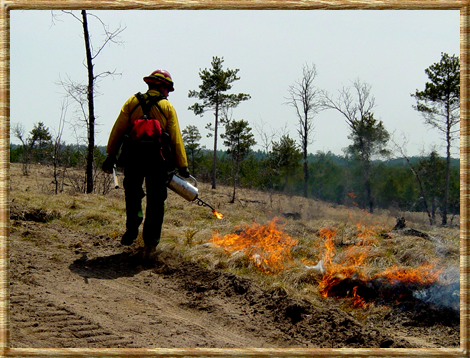
As a natural process of a forest ecosystem, prescribed burning is used for the improvement of forest habitat and the regeneration of several plant species, as well as reducing the buildup of dead grasses, twigs, and down branches that can fuel forest fires.
The Huron-Manistee also promotes wildland fire prevention through an on-going relationship with the Smokey Bear program. Smokey is often seen as grand marshal at local parades, visiting schools, and putting in appearances at local events.
On the Huron-Manistee there are two distinct areas as pertain to fire.
The first, referred to as the East Zone encompasses 438,000 acres of National Forest System Lands and has a history of high intensity fires and a high level of wildland/urban interface. This area is also the natural habitat of the endangered Kirtland's warbler. The habitat is jack pine, a fire dependant tree.
Between 1996 and 2005 the East Zone had an average of 45 fires a year that burned an average of 700 acres a year. Several large fires have occured in the East Zone including the Mack Lake Fire in 1980 and more recently the Hughes Lake fire in 2005. These fires were large and spread rapidly. Both of these fires caused damage to private property.
The other fire management zone on the Huron-Manistee National Forests is called the West Zone and consists of 540,000 acres. Forest Service ownership in this area is scattered and there are large urban interface areas. This area also has habitat for the endangered Karner Blue Butterfly and contains the Nordhouse Dunes Wilderness Area. The West Zone had the No Pablo fire.
The fire "season" on both zones begins around April 1 and continues until about Octobrer 30. Essentially, beginning with the first major snow melt and ending with the first major snowfall. Low humidity, windy conditions, and flammable vegetation are all factors in the timeframe for fire season. The average rainfall during fire season is 19 inches on the East side and 24 inches on the West Side. Spring brings dry, cold fronts and low humidity with high winds, moving into a summer of extended dry periods and thunderstorm activity. In the fall vegetation becomes dry and there are long periods without rain. Both areas have stands of jack pine and oak, red pine stands and areas with large amounts of hardwood stands.
For Healthy Forest Restoration Act fuel reduction projects, please visit the project section of our website.
Fire Links - Local and National
Firewise Program
Burning Permits
Prescribed Burning on the Huron-Manistee
|