Site Map
News
Organization
Search
Travel Wx
Home
Hazardous Weather
Severe Weather Page
Hazardous Wx Outlook
Weather Safety
Report Severe Wx
Skywarn™Spotter Info
StormReady
Tsunamis
EM Page
General Weather
Text Forecast
Weather Discussion
Graphical Forecast
Activity Planner
Data
Current
•
Models
Current
FL
•
GA
•
More
Marine Weather
Marine Weather Page
Text Forecast
Surf Zone Forecast
Local Tide Info
Report Weather
Climate
Climate Page
Submit Co-op Obs
CoCoRaHS Rain Net
Sun & Moon Data
Hydrology/Rivers
Rivers & Lakes AHPS
Precip Analysis
River Forecast Center
Tropical Weather
Tropical Weather Page
Local Tropical Graphix
Nat'l Hurricane Center
NOAA Outlook
Area History
HTML
PDF
Other Pages
Aviation Weather
Fire Weather
Radar Imagery
Latest
KJAX
•
KVAX
Status
KJAX
•
KVAX
Other Data
Satellite Imagery
Vis
Local
•
SE
•
US
I-R
Local
•
SE
•
US
Other Data
NOAA Weather Radio
General Info
Local Transmitters
Local SAME Codes
Broadcast Sequence
Special Pages
About Our Office
Newsletter
•
Archive
Local Research
Storm Surveys
Wireless Access
FAQ
•
What's New?
Weather Calculators
Misc. Pictures
NWS Publications
Education
Contractions
Glossary
Terms
Public
•
Marine
Links
Other NWS Offices
Weather Links
IWIN
FL
•
GA
Official Time
NWS Jacksonville Home
»
Hydrological Data
River Warnings, Statements, and Forecasts
River Forecasts
River Flood Warnings
River Flood Statements
River Statements
NE Florida Current River Conditions
Georgia Current River Conditions
Current River Levels in North Florida
SE Georgia River Summary
Georgia River Summary
River Flood Outflook Graphic
24-Hour River Flooding Outlook Graphic
Significant River Flood Outlook Graphic
Hydrologic Outlook
Hydrological data from elsewhere in the US...
Florida
Georgia
--------------------------
Alabama
Alaska
Arkansas
Arizona
California
Colorado
Connecticut
Delaware
Hawaii
Idaho
Indiana
Iowa
Illinois
Kansas
Kentucky
Louisiana
Maine
Maryland
Massachussets
Michigan
Minnesota
Mississippi
Missouri
Montana
Nebraska
Nevada
New Hampshire
New Jersey
New Mexico
New York
North Carolina
North Dakota
Ohio
Oklahoma
Oregon
Pennsylvania
Puerto Rico
Rhode Island
South Carolina
South Dakota
Tennessee
Texas
Utah
Vermont
Virginia
Washington
West Virginia
Wisconsin
Wyoming
Georgia Hydrographs
(Links provided by the U.S. Geological Survey)
--- Altamaha Basin ---
Ocmulgee R. at Lumber City
Oconee R. at Dublin
Altamaha R. near Baxley
Ohoopee R. near Reidsville
Altamaha R. at Doctortown
Brunswick R. at St. Simons
--- Satilla Basin ---
Satilla R. near Waycross
Satilla R. at Atkinson
--- Suwannee Basin ---
Suwannee R. near Fargo
Alapaha R. at Statenville
Withlacoochee R. near Bemiss
Other Georgia Data
•
NWS Office of Hydrology Page
Florida Hydrographs
(Links provided by the U.S. Geological Survey)
--- St. Marys Basin ---
St. Marys R. near Macclenny
--- St. Johns Basin ---
St. Johns R. near Deland
St. Johns R. at Buffalo Bluff
Dunns Cr. near Satsuma
Etonia Cr. at Bardin
Rice Cr. near Palatka
Deep Cr. at Spuds
Sixmile Cr. near Picolata
Black Cr. (North Fork)
Black Cr. near Doctors Inlet
--- Ocklawaha Basin ---
Ocklawaha R. above Moss Bluff
Ocklawaha R. at Moss Bluff
Silver Spgs. near Ocala
--- Withlacoochee Basin ---
Withlacoochee R. near Holder
Suwannee Basin:
Moores Pond near Micanopy
Suwannee R. (North Fork)
Suwannee R. at White Springs
Withlacoochee R. near Pinetta
Withlacoochee R. near Lee
Suwannee R. at Ellaville
Suwannee R. at Branford
Bad Dog Branch near Alachua
Santa Fe R. near Hildreth
Suwannee R. near Wilcox
Clickable Map
•
Other Florida Data
•
NWS Office of Hydrology Page
Precipitation Data
Regional Precipitation Tables
Regional 24-Hour Radar Precip. Estimates
Jacksonville Area
Charleston Area
Atlanta Area
Tallahassee Area
Tampa Area
Melbourne Area
Jacksonville Area
Charleston Area
Atlanta Area
Tallahassee Area
Tampa Area
Melbourne Area
Precipitation Forecasts
[Excess Rainfall Potential]
[Area QPF Text]
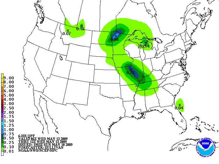
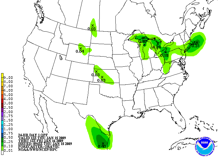
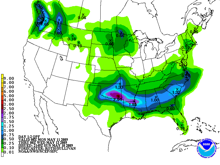
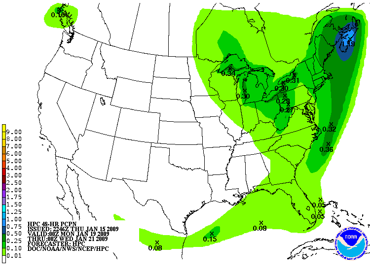
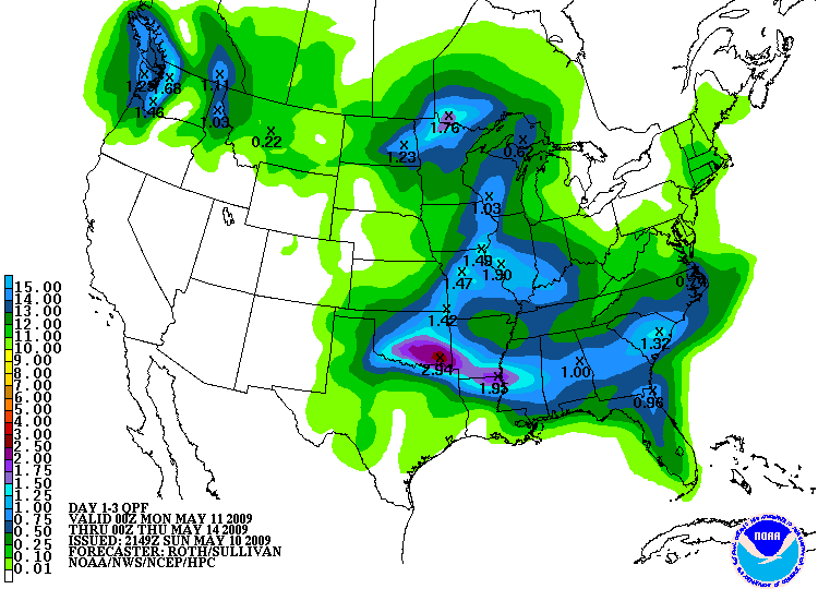
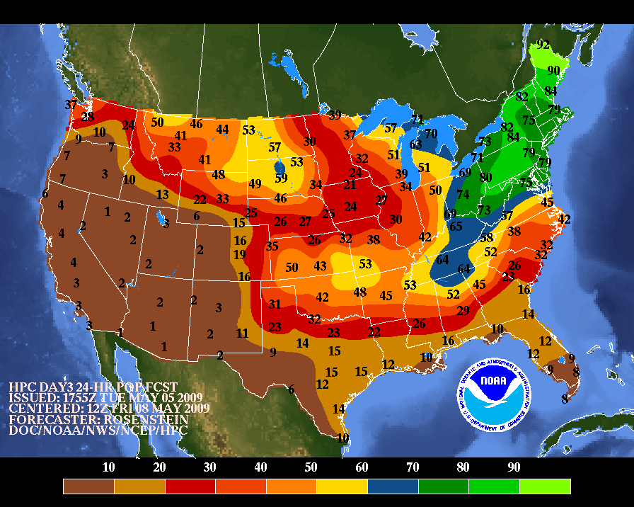
HPC U.S. Quantitative Precipitation Forecast Graphics (QPF)
00-06
Hour
06-12
Hour
12-18
Hour
18-24
Hour
24-30
Hour
30-36
Hour
36-42
Hour
42-48
Hour
48-54
Hour
54-60
Hour
60-66
Hour
66-72
Hour
72-78
Hour
X
X
X
X
X
X
X
Day 1
Day 2
Day 3
X
X
D a y s 1 - 2
X
D a y s 3 - 5
D a y s 1 - 3
X
D a y s 1 - 5
HPC U.S. Precipitation Probability Forecast Graphics
Day 3
Day 4
Day 5
Day 6
Day 7
Drought Information
Keetch-Byram Drought Index (Florida)
Keetch-Byram Drought Index (U.S.)
Long-Term Palmer Drought Index
Crop Moisture Index
Regional Monthly Rainfall with Departure from Normal
Water Resources Outlook
What is a drought?
Questions or comments about the Jacksonville hydrology program?
Email
David Shuler
, hydrology focal point.
Monthly Rainfall Maps
Select month:
AUG 2008
JUL 2008
JUN 2008
MAY 2008
APR 2008
MAR 2008
FEB 2008
JAN 2008
DEC 2007
NOV 2007
OCT 2007
SEP 2007


)
)
)
![[Excess Rainfall Potential]](https://webarchive.library.unt.edu/eot2008/20090115221604/http://www.hpc.ncep.noaa.gov/qpf/94ewbg.gif)
)
)
)
)