- About CI-FLOW
- About NOAA nowCOAST
- CI-FLOW News
- Collaborators
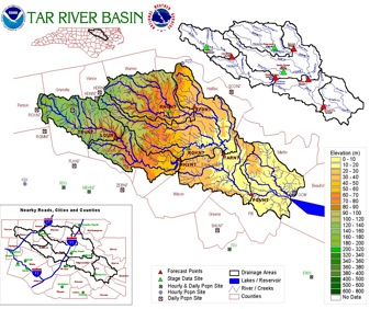
CI-FLOW (the Coastal and Inland Flood Observation and Warning Project) is a multi-agency project to evaluate and test new technologies to produce accurate and timely identification of inland and coastal floods in the Tar-Pamlico and Neuse river basins of coastal North Carolina.
CI-FLOW was initiated in response to devastating human and economic losses caused by storm-surge and coastal flooding from Hurricanes Floyd and Dennis in 1999. Flooding is the number one hazardous weather-related killer in the U.S.
NEW! CI-FLOW 5 Year Project Plan (.doc, 2.5 MB)

NOAA's nowCOAST ![]() is a GIS-based web mapping portal providing integrated, one-stop access to on-line, real-time coastal environmental observations and NOAA forecasts for any region in the coastal United States. NowCOAST provides users with displays of the latest surface weather and ocean observations, satellite cloud imagery, weather radar reflectivity mosaics, sea surface temperature analyses and gridded forecasts.
is a GIS-based web mapping portal providing integrated, one-stop access to on-line, real-time coastal environmental observations and NOAA forecasts for any region in the coastal United States. NowCOAST provides users with displays of the latest surface weather and ocean observations, satellite cloud imagery, weather radar reflectivity mosaics, sea surface temperature analyses and gridded forecasts.
CI-FLOW passes test from Hanna

Hurricane Hanna
Tropical Storm Hanna tested the components of the CI-FLOW monitoring and prediction system when it made landfall in North Carolina in on September 6, 2008. CI-FLOW met expectations with high levels of correlation between the CI-FLOW model component estimates and traditionally measure rainfall and storm surge recordings.
CI-FLOW rainfall estimates during the storm were produced by NOAA NSSL’s Q2 system, which produces precipitation estimates for the U.S. every five minutes using radar, satellite, lighting and atmospheric data sets. Post-event verification, available on the Q2 home page ![]() , indicates the NSSL rainfall reports performed well in detecting the spatial extent and characteristics of the rainfall. Storm surge forecasts produced by CI-FLOW partners at the University of North Carolina at Chapel Hill (UNC-CH) accurately predicted the coastal surge levels of one-three feet.
, indicates the NSSL rainfall reports performed well in detecting the spatial extent and characteristics of the rainfall. Storm surge forecasts produced by CI-FLOW partners at the University of North Carolina at Chapel Hill (UNC-CH) accurately predicted the coastal surge levels of one-three feet.
The CI-FLOW research team will continue to investigate linking inland river models and coastal ocean/estuary models, each using input from high-resolution weather forecast models and multi-sensor precipitation estimates. This capability will increase the accuracy of water level forecasts in the tidal plain by ensuring storm surge impacts and inland streamflow conditions are taken into account.

The CI-FLOW research consortium comprises a number of federal agencies and university programs.
NOAA/NWS
- NOAA National Severe Storms Laboratory
- North Carolina
 and South Carolina Sea Grant Programs
 - National Sea Grant College Program
- NWS Weather Forecast Offices of North Carolina and South Carolina
- NWS Office of Hydrologic Development
- NWS Southeast River Forecast Center
- NOAA in the Carolinas
- NOAA Coastal Services Center
- Texas Sea Grant
University Partners
- The University of Oklahoma
- NOAA/OU Cooperative Institute for Mesoscale Meteorological Studies
- North Carolina State University
- University of North Carolina at Chapel Hill