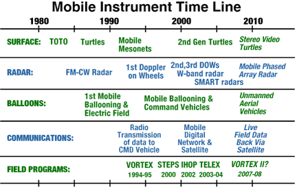
Mobile observing facilities* are ideal for intercepting and moving with weather systems. Scientists trying to understand the dynamics of weather gain valuable knowledge by analyzing data sets collected in the field using innovative mobile and deployable observing systems. Mobile observing systems include:

One of NSSL's SMART-R mobile Doppler radars
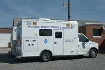
NSSL has two of these versatile vehicles, providing either mobile or fixed command and control, mobile ballooning launch and data telemetry reception, and mobile or fixed data acquisition. The crew can be up to 5 persons while driving (more if stationary).

A fleet of mobile mesonets (larger image) is ready for deployment.
- SMART-RADARS for data collection to study convective
and mesoscale atmospheric processes during significant weather events
such as flash floods, hurricanes and tornadoes.
NSSL collaborated with Texas A&M, Texas Tech and the University of Oklahoma to build the Shared Mobile Atmospheric Research and Teaching Radars, or SMART-RADARS. Two truck-mounted, 5-cm wavelength Doppler radars operate on a different frequency than other mobile radars, allowing them to scan and penetrate through an entire tornadic storm or hurricane. Previously, NSSL personnel were recognized with a Department of Commerce Bronze Medal for fabricating the first Doppler-on-Wheels (DOW), jointly developed with OU researchers and the National Center for Atmospheric Research. - MOBILE BALLOONING LABORATORIES for surface measurements
and upper air soundings
The mobile laboratories, developed at NSSL, measure surface meteorological variables and receive GPS-located data from balloons instrumented with radiosondes, electric field and lightning sensors, and other specialized probes in all types weather during both day time and night time. Different types of balloons are used to launch instruments depending on the weather conditions and the project goals. During one recent field experiment, scientists found evidence for inverted, or reversed, polarity structures within thunderstorms. The evidence for this came from electric field data obtained with free-flying instrumented balloons. Photos and videos of balloon launches
- MOBILE MESONET VEHICLES designed for tornadic and
other severe storm intercept.
Mobile mesonets - automobiles outfitted with rooftop surface weather stations - are driven into positions near tornadoes to study the airflow around them. Scientists in the field take measurements and photographs throughout a storm's entire lifecycle, collecting data that will either support or refute different ideas regarding thunderstorm, lightning and tornado formation. Sample field communications during VORTEX-95
- FIELD COORDINATION VEHICLE for organizing and communicating
storm intercept activities in real-time.
A mobile laboratory can be configured with communication equipment to serve as a field command unit. Mobile mesonet rooftop weather observations, SMART-Radar base scans, soundings, and location information are broadcast over a mobile digital radio network to the field coordinator who then plots the information and directs team members in real-time to ideal field positions. The field coordination vehicle uses a 900 MHz antenna mounted on a 10 meter deployable mast. Displays are transmitted to the the Internet via broadband satellite uplink. In the future mobile digital technology like that developed at NSSL for field communications might be used in a mobile "spotter network" at NWS offices or by emergency managers in disaster mitigation and recovery efforts.
- NOAA P-3 AIRCRAFT SUPPORT for collecting data during
large field campaigns
In addition to collecting basic weather and precipitation information, NOAA P-3 instrumented research aircraft use Doppler radars in the nose, tail, and lower fuselage to measure wind speed and direction inside storms.
* NSSL observational facilities may be available for research projects being planned or already funded. Contact Dave Rust at dave.rust@noaa.gov for details.
