Early Spring Basin Conditions
March 6, 2008
HUDSON BAY DRAINAGE
SUMMARY OF PAST AND CURRENT CONDITIONS
Red River of the North River Basin: The NOHRSC recorded soil moistures in the Red River Valley in early November at about 20 to 25 percent in the upper 20 cm with their gamma survey aircraft. Wilkin County reports the top foot of soil is bone dry in the headwaters of the Red River Valley.
The Palmer Drought Index for the Red River Valley is near normal. The U.S. Drought Monitor has indicated the Red River Valley as "Abnormally Dry" as of February 26.
In Fargo the normal water equivalent for November to February is around three inches. Currently the modeled water equivalent in the Fargo area a little over two inches. The average modeled water equivalent is a little over two inches for the entire Valley. Frost depth averages around 3 feet.
Devils Lake Basin: Soil conditions in the basin were slightly dry entering the winter as the U.S. Drought Monitor indicates that conditions are abnormally dry. Despite near normal precipitation this winter, precipitation last fall was 1 to 2 inches below normal. NOHRSC airborne gamma soil moisture readings indicated 20 to 25 percent moisture in the upper portion of the soil.
Snow water equivalent values range from about 1.5 inches in the south to 2 inches in the north and nearly 2.5 inches in the northeast.
Devils Lake and Stump Lake have equalized and are at a level of about 1447 feet down from a high last June of 1447.95 feet and a record high of 1449.20 feet in May of 2006.
Less than half an inch of precipitation has fallen over the Devils Lake Basin during the past 2 weeks. This additional precipitation has been added to the snowpack. Spring runoff has not started yet and the lake level remains steady.
Long range simulations for Devils Lake this month assume that no water will be pumped from Devils Lake this year. Last year the pump was rarely operated if at all.
Souris River Basin: Severe hydrologic drought conditions persist over most of the Souris River Basin with an area of extreme drought appearing this week in the vicinity of Westhope ND. During the past year precipitation totals have been about 3 to 6 inches less than normal. The NOHRSC airborne gamma soil moisture readings indicated less than 15 percent moisture in the upper portion of the soil.
Less than half an inch of precipitation has fallen over the Souris River Basin during the past 2 weeks. This additional precipitation has been added to the snowpack. Spring runoff has not started yet.
Lake Darling upstream of Minot ND is currently below it's target elevation so it will be storing much of the inflow it receives this spring.
The J. Clark Salyer National Wildlife Refuge (NWR) along the Souris River between Bantry ND and Westhope ND contains several reservoirs that are managed primarily for wildlife. This spring they would like to raise the level of these reservoirs. A preliminary estimate of the volume required by the NWR was incorporated into our long range hydrologic simulations.
The Eaton Project on the Souris River near Towner ND withdraws water from the river in the spring to irrigate fields adjacent to the river. This withdrawal has also been incorporated into our simulations.
Between 1 and 2 inches of snow water equivalent are present in the Canadian and far northeastern portions of the basin. However, the middle portion of the basin has less than an inch of water equivalent.
GREAT LAKES DRAINAGE
SUMMARY OF PAST AND CURRENT CONDITIONS:
Upper Peninsula of Michigan River Basins: Fall precipitation for September to November was above normal. October had twice normal precipitation. Average temperatures were a few degrees above normal. December precipitation was normal east to almost twice normal in the west. Temperatures were near normal.
January was a wet month around the Great lakes. Precipitation was normal west to almost twice normal for the east. Snowfall was well above normal, more than 60 inches, due to several lake effect snows. Temperatures were 2 to 5 degrees above normal.
February precipitation averaged close to normal while temperatures are a few degrees below normal west to a few degrees above normal east.
The U.S. Drought Monitor for December 2007 through February 2008 shows the area is in the "Abnormally Dry" category.
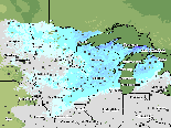
Snow Depths averaged 15 to 25 inches along the southern half of the peninsula and 25 to 45 inches along northern half. Snow water equivalents are generally 2 to 5 inches with amounts from 6 to 9 inches along the north shore in the lake effect snow areas.
According to the USGS the rivers are flowing near normal for much of this region.
Menominee River Basin: According the U.S Drought Monitor western and southern portions of the Menominee River Basin are "Abnormally Dry". This is an upgrade compared to the last outlook. The USGS shows most of the rivers at normal flow. The higher flow conditions are likely due to warmer than normal temperatures and high dew points in January for two different precipitation events. These events had a little rain but mainly created snowmelt runoff.
Contributing to the dry state of the Menominee has been below average precipitation for the 60 to 90 days prior to early February. Early to mid February was also below average for precipitation. However a couple snow storms in late February have brought the monthly totals back to normal except for southwestern portions of the Menominee. The northern portion of the basin is about normal for snow water equivalent but the central and southern portions are running about 80 percent of expected SWE. Recent warm weather wasn't significant enough to create snowmelt runoff. A more precise measurement of SWE is expected around March 6th when WE energy conducts a comprehensive snow survey for most of the area and NOHRSC will also have finished an aerial survey.
Frozen ground depth ranges from 1 to 3 ft depending on the whether it's in an open area or forested region.
Ice has been an issue affecting gage stages but thus far hasn't been an issue for ice jam flooding.
Northern Lower Michigan Basins : For the Northern Lower Michigan basins which include the Manistee, Boardman, Au Sable, and Rifle Rivers fall precipitation(September through November) was generally near normal with a slightly dryer than normal while November was about 50 to 75 percent of normal. Streamflows during this same period were below normal to normal with November falling in the much below normal category, less than 24 percent of normal due to below normal precipitation for the month.
As Winter began, precipitation was near normal for December and 150 to 200 percent above normal in January. Streamflow rebounded in January due to the above normal precipitation and was rated at normal to above normal or greater than 76 percent and remained above normal through February (USGS).
According to the USGS, the rivers are flowing near normal for much of this region.
Snow water equivalents of the snowpack range between 2 and 4 inches. Current snow depths range from 8 to 15 inches in the north and 15 to 22 inches in the south.
Grand Muskegon White and Saginaw Basins: For the Grand, Muskegon, White, and Pere Marquette River basins the MRCC charts indicate that Fall precipitation (September through November) was about 50 to 75 percent of normal. Going into the winter months, December was near normal while January became fairly wet with values running from 125 to 200 percent of normal.
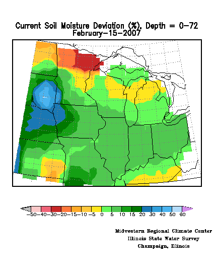
Also from the MRCC, current soil moisture is indicated to be somewhat above normal, running in the range of about 15 to 30 percent above the average for this time of year.
Additional snow storms added to the snowpack through March 1. Then on March 2 into March 3 a brief but sharp warm up occurred which created some snowmelt at the same time that a line of rain storms moved through. Moderate within bank river rises were forecast to occur from this rain and snowmelt event, but no flooding was predicted in the short term due to the fact that colder temperatures were expected to move quickly back into the region for the rest of the week.
USGS'S flow statistics indicate above normal conditions for most of the area.
Kalamazoo, St. Joseph, and Southeastern Michigan Streams: This region went into the winter with slightly drier than normal soil moisture conditions. However, as the winter progressed precipitation amounts have been running well above normal. Over the past 90 days precipitation amounts were 150 to 200 percent of normal resulting in moderate to major flooding over the St. Joseph River and several river basins in southeastern Michigan.
Wetter than normal conditions remain across the area. Moderate flooding occurred two weeks ago on parts of the KSJ and minor flooding is currently occurring on both parts of the Kalamazoo and St. Joseph rivers.
Snow cover has receded northward over the past three weeks despite snow storms that yielded their heaviest amounts over the Grand and Muskegon River basins. The St. Joseph River is snow free and the Kalamazoo basin has 1 to 4 inches of snow remaining. The Saginaw River basin has 4 to 10 inches of cover with 2 to 3 inches of snow water equivalent across most of the area. The Southeastern Michigan Streams have 2 to 6 inches across most of the area. Snow water equivalent in this area is generally less than an inch.
USGS flow statistics indicate that river levels are still running above normal but not to the extreme they were three weeks ago.
Eastern Wisconsin Streams: The MRCC charts indicate that Fall precipitation which encompasses last September through November was about 50 to 100 percent of normal. Then going into the Winter months December and January were wetter with values running from 150 to 200 percent of normal in December to about 125 to 175 percent above in January 2008.
Also from the MRCC, current soil moisture is indicated to be somewhat above normal ranging from 5 percent above in the north to about 20 percent above in the south around Milwaukee.
Minor flooding occurred in early January on the Root River and some localized flooding due to ice jams also occurred on the Sheboygan and other nearby rivers in southeast Wisconsin in late January.
More storms have moved through over the last two weeks and added to the snowpack. In particular, on March 2 to March 3, a messy combination of rain, freezing rain, and snow fell, depositing an additional inch or more of moisture in many locations which mostly froze in place due to cold air that moved quickly into the region at the end of the storm. Water equivalents now range from a low of about 1.5 to 3 inches in the far south around Milwaukee to upwards of 5 to 6 inches in the central and northern sections which comprise the Wolf-Fox basin.
USGS flow statistics indicate near normal conditions in the northern half including basically all of the Wolf and Fox Rivers and above normal in the south.
Western Lake Superior Streams: Fall precipitation, September through November, began about 125 to 175 percent of normal then slowing down in November with 25 percent of normal precipitation. Streamflows during this same period were much above normal or greater than 90 percent in October according to the USGS. Streamflow condition returned to normal in November with the reduction in the normal amount of precipitation for the month.
Going into the Winter months, December precipitation was much above normal, 150 to 200 percent, and streamflow conditions returned to much above normal flows or greater than 90 percent. In January precipitation was about 50 percent of normal.
Snow water equivalents of the snowpack are around 2 to 3.5 inches. Current snow depth ranges from 6 to 26 inches.
Grand Marais, Minnesota is the only location in the state to have received above normal precipitation since November 1 2007.
According to the USGS, the rivers are flowing normal for this time of year.
UPPER MISSISSIPPI RIVER DRAINAGE
SUMMARY OF PAST AND CURRENT CONDITIONS:
TRIBUTARIES OF THE MISSISSIPPI RIVER MAINSTEM
MINNESOTA TRIBUTARIES TO THE MISSISSIPPI RIVER:
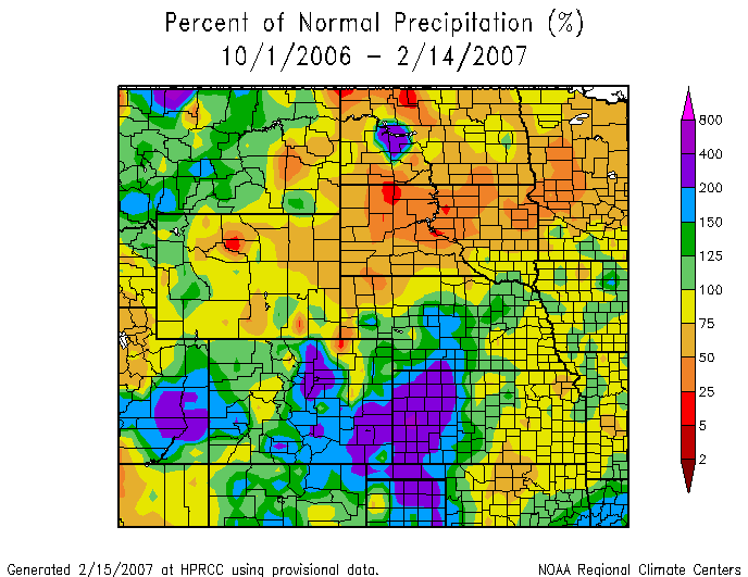
Minnesota River Basin: The MRCC charts indicate that Fall precipitation was about 125 to 175 percent of normal with the wettest area being in the upstream headwaters out west where heavy rains fell last August into September. Going into the Winter months December was variable throughout the basin running from 75 up to 150 percent of normal, while January 2008 was well below normal running in the range of only 5 to 50 percent.
Also, the MRCC indicated current soil moisture to be high out west largely due to the rains that fell last August and September with values running from about 20 to 50 percent above the normal range in the western sections of the Minnesota River while soil moisture values in the east are just a little above normal, only about 5 to 15 percent above.
Current water equivalents of the snowpack range from only about 0.40 to 0.80 inches in the headwater areas of west-central Minnesota to about 1.5 to 2.5 inches in the lower portion of the basin in southcentral Minnesota. Snow depths vary respectively from about 4 inches or less out west to about 6 to 12 inches east and south where considerable settling and compacting has occurred.
Frost depths range from about 3 feet or more out west to about 2 feet east. Cold weather January into February has produced quite a bit of ice in area rivers and streams.
There has been no recent significant river activity and most locations are currently well below flood levels.
USGS flow statistics are either not available or not applicable at this time due to the extensive river ice conditions occurring this season.
WISCONSIN TRIBUTARIES TO THE MISSISSIPPI RIVER:
Chippewa River Basin: The northern reaches of the Chippewa basin had been in drought most of 2007 but autumn precipitation of 125 to 150 percent above normal across the basin helped to alleviate that considerably.
Snow depth is near normal across the basin but snow density remains very high. Snow depth across the basin ranges from 5 to 10 inches in the western half to 10 to 20 inches across the east. The water equivalent of that snow ranges between 3 and 4 inches in the north but drops to between 1.5 and 2.5 inches in the south.
Soil moisture conditions across the basin are near normal at both 12 and 72 inches.
USGS Streamflow is around normal for most of the basin except for the far north where it continues low at about 20 percent of what is expected for this time of year.
Wisconsin River Basin: The upper portion of the basin is shown on the U.S. Drought Monitor as being in a "Abnormally Dry" condition while the rest is considered to be in a "Normal or Better" condition.
Rain fell across the central part of the basin just before Christmas and again in early January raising flow on the river in January to about 50 percent above the seasonal normal and the highest flow since June 2006.
Snow cover in the basin ranges from 7 to 25 inches of snow. Modeled snow water equivalent values across the basin generally average between 4 to 6 inches. Both Madison and Green Bay snowfall records have been broken this year, and both of these observation stations have periods of record going back into the 1800s. Since there have been a few periods of warm temperatures and subsequent snowmelt in Wisconsin, the current snow depth in Madison is at 9 inches after over 90 inches of total snowfall.
Current streamflow is about 110 to 150 percent of the seasonal norms on the smaller rivers and near normal at the lower end of the Wisconsin River. Storage in the headwaters reservoirs have been drawn down to their lowest level since 2001, currently about 30 percent of available storage.
IOWA TRIBUTARIES TO THE MISSISSIPPI RIVER:
Cedar and Iowa River Basins: December precipitation was as little as 50 to 90 percent of normal over the northern part of the basin to as much as 200 to 300 percent of normal across much of the southeastern area. In January precipitation ranged from as little as 25 percent in the northern areas to near 100 percent in a small part of the central basin and 50 to 90 percent over the rest.
February precipitation ranged from about 75 percent in the north to 125 to 150 percent over most of the basin and 200 to 300 percent in the eastern area. All together the northern part of the basin is about 0.50 to 1 inches below normal precipitation and the eastern part of the basin is about 2 to 3 inches above normal.
Reported snow depths across the basin average about 10 to 12 inches but there was an early winter storm that left 1 to 2 inches of ice over much of the lower basin. Snow water is currently being modeled at 2 to 4 plus inches.
Coralville reservoir is at its normal level for this time of the year.
Warm temperatures this past weekend did melt some of the snow in the lower portion of the basin and is causing high water conditions along the Iowa River primarily.
Currently the Cedar River is running at about 200 to 250 percent of normal while the Iowa River is running about 300 percent above normal above Coralville Dam and 200 percent of normal below the confluence with the Cedar River.
Skunk, Maquoketa and Wapsipinicon River Basins: The Iowa Tributaries have been wetter than normal over the past six months with the Standardized Precipitation Index (SPI) indicating extremely wet in the northeast basins and very wet over most of the Skunk basin.
Soil moisture from MRCC shows 15 to 30 percent above normal soil moisture conditions as a result of the wet conditions. However the 72 inch soil moisture indicates only about 10 to 15 percent above normal.
Much of the snow over the lower Skunk and lower Wapsipinicon has melted from recent warm temperatures. This is causing minor to moderate flooding in the short term window. In the upper Wapsipinicon and Maquoketa most of the 4 to 8 inch snowpack remains. The snowpack on the lower Wapsipinicon still ranges from 5 to 12 inches and snow water currently being modeled is at 2 to 4 plus inches. Consequently the flood threat remains higher than normal this year on the Iowa tribs especially the Wapsipinicon and Maquoketa rivers where the snowpack remains well above normal.
Des Moines River Basin: Due to recent warm temperatures and some rainfall over the past week... snowmelt runoff has appeared in some of the tributaries of the Des Moines River. Ice jams are also fairly common... causing major flooding on the South River at Ackworth. The ice jam at Ackworth broke free on Monday and the water is showing up on the mainstem Des Moines River.
There is still over two inches of water equivalent in the headwaters of the Des Moines River... with amounts around an inch or less in the southern basin.
Soils in the Des Moines River basin are very moist. Any additional rainfall or snowmelt is likely to cause runoff. The next warm up causing potential snowmelt may occur over the weekend.
According to the USGS... the southern half of the river basin is currently flowing at greater than 90 percent average flow for this time of year. The Raccoon River at Van Meter crested on Monday at about 20000cfs. The average flow for early March based on 92 years of record at Van Meter is about 1000cfs.
Illinois River Basin: Soil conditions in September through November 2007 were normal throughout the basin with the exception of the Calumet and Kankakee River Basins where streamflow conditions were above normal due to the continued above normal precipitation pattern in much of the region. The remainder of the Illinois River basin began to increase its soil moisture conditions from the above normal precipitation pattern in December. This pattern pushed streamflow conditions into the above normal category as well. Precipitation since January 1st has been around 200 percent of normal.
During the past 2 weeks two storm systems have moved through the region which have added to the snowpack and soil conditions. Both storms left a mix of snow...sleet and rain resulting in an increase to water equivalent amounts generally between a half to three quarters of an inch in most of the Kankakee...Fox and Des Plaines River basins including the upper portion of the mainstem Illinois River...above Peoria. Water equivalent amounts increased around a half of an inch in the Sangamon... Spoon and Lamoine River basins including the lower portion of the mainstem.
Warm temperatures rolled into the area during the weekend of March 1st and have melted the snowpack in the Kankakee and Iroquois River basins. Once again...due to the cold temperatures over the past couple of days many rivers and streams have either had their rises slow down or the rivers have stopped rising and are now beginning to fall slowly. It is likely that some of the runoff has not yet made it to the rivers and has frozen in place.
Modeled snow water equivalents in the Fox and Des Plaines River basins continue to range between 1 and 3 inches.
Streamflow conditions in Illinois are generally greater than 90 percent or much above normal.
Rock River Basin: During the Summer and Fall of 2007 the Rock River Basin received 100 to 125 percent of normal precipitation. Most of this precipitation fell in August and caused the Rock River to rise from a baseflow of about 4 kcfs to a crest around 35 kcfs at Joslin by the end of the month.
This event set the stage for a winter full of ice jams in the basin. Several cold snaps resulted in significant river ice production and freeze-up ice jams at several locations along the Rock River. Some jams caused significant flooding.
This winter has seen 15 to 40 inches more snowfall than normal across the basin with the highest snowfall amounts of about 80 inches in the Wisconsin portion of the basin. As a result of midwinter thaws...much of the snow in the southern portion of the basin has melted already.
In the past 2 weeks between 1 to 1.5 inches of precipitation fell over the Rock River Basin. About a third of the precipitation fell as snow at the end of February and the rest fell mostly as rain on March 3rd. This rain and some accompanying snowmelt has caused rivers to rise throughout the basin. The most significant rises occurred in the Kishwaukee and Pecatonica watersheds downstream to Moline on the Rock River. Ice jams continue to exacerbate the flooding problems all along the Rock River but especially at Joslin and Moline where major to record flooding is occurring.
Simulated snow water equivalents on the ground range from about 1 inch near the mouth of the basin to 4 inches at the Illinois/Wisconsin border to around 6 inches in the headwaters of the basin. There is little soil frost in the basin but soils are very wet from last fall and snowmelt during early winter.
Streamflow conditions in Rock basin are generally above normal to much above normal or greater than 90 percent.
Kaskaskia and Big Muddy River Basins: A somewhat normal autumn has gradually turned into above normal conditions as far as rainfall and soil moisture are concerned. Precipitation for the Kaskaskia and Big Muddy Rivers has been 150 to 200 percent of normal since the beginning of the year.
Currently...flows are high on the Kaskaskia River due to repeated rainfall events and warm temperatures over the past couple of weeks. The Big Muddy Basin is very wet...with forecast points near flood stage this past week and large amounts of water releasing from area reservoirs.
Streamflow conditions are generally above normal to much for this time of year...76 to 90 percent.
MISSOURI TRIBUTARIES TO THE MISSISSIPPI RIVER
Fabius, Fox, Salt and Cuivre River Basins: Cold wet weather has continued since the middle of February. Temperatures during the period averaged 3 to 5 degrees below normal. Precipitation during the period was between 1.5 and 2.5 inches...or about 125 to 250 percent of normal. Snow was mainly confined to the northern portion of the basin with the heaviest near the Iowa border. A brief warm up and heavy rain on March 2nd and 3rd melted off the remaining snow in the basin and caused many rises to around or a little above bank full.
The latest streamflows were above normal with most stations above the 75th percentile. The Wyaconda and Fabius Rivers were ranked above the 90th percentile.
Meramec River River Basin: Fall was dry across the Meramec basin as only about 50 percent of the normal precipitation fell. The start of winter though has seen a wet December and January which was between 100 to 150 percent of normal precipitation has fallen. This excess precipitation has brought the Level 1 drought conditions of the fall back into the normal range by mid-winter.
Since Sunday rain and snow have fallen in the Meremac Basin. Liquid precipitation totals between 1 and 2 inches have caused within banks rises in the rivers. The Meremac River at Arnold is forecast to just reach flood stage at the end of the week.
According to the USGS...streamflows are running much above normal for this time of year...greater than 90 percent.
MISSISSIPPI RIVER MAINSTEM :
Mississippi River from the Headwater Area to Red Wing MN: The Mississippi River basin upstream of St Cloud Minnesota had been in a severe to extreme drought since last year. Precipitation from September to November was in the normal range...and for December in the normal range except for the headwaters. Currently most of the basin has moved into the Near Normal group. The exception being the headwaters which remains in the Severe Drought group.
Water equivalents are in the 2 to 3 inch range for the headwaters with the remaining part of the basin in the 2 to 5 inch range.
Flows at St Cloud were about 50 percent of normal last Fall...up just a little from 2007 flows.
Mainstem river low flows continue to be a concern to navigation. The Mississippi River at St. Paul Minnesota is currently modeled around 3600 cfs. The mean flow for March is 11200 cfs for the period of record, 1892 to 2006. The all time low flow for March is 1757 cfs in 1940.
Mississippi River from Lake City, MN to Lock/Dam 10 at Guttenberg, IA: Streamflow in the tributaries of this reach of the Mississippi is classified as near normal for February 2008.
September to November precipitation over the area was normal except for the southeastern corner of Minnesota and northeastern Iowa which was below normal. While the December precipitation was normal for most of the Minnesota part of the basin and above normal for the far southeastern corner of Minnesota and northeastern corner of Iowa which was 150 to 200 percent of normal.
For most of the area, the Drought Monitor indicates Unusual Moist Spell with the Wisconsin area of the lower reach being in the Very Moist Spell category.
Frost depths currently range between 1 and 2 feet.
At the end of February the Corps of Engineers Locks and Dams location ice thickness ranged from 4 to 20 inches.
Lower mainstem river flows have been a concern to navigation for a number of months. Currently the Mississippi River at Winona MN flow is being modeled at about 10000 cfs. The mean flow for March for the current period of record is 30400 cfs. The all time low flow for March was 9000 cfs in 1934. The period of record is July 1928 to the present.
Mississippi River from Lock/Dam 11 at Dubuque IA to Dam 22 at Saverton MO: For the mainstem Mississippi River basin from Dubuque Iowa down through Gregory Landing Missouri the MRCC charts indicate that Fall precipitation...which encompasses last September through November was slightly above normal in the north but only 50 to 75 percent of normal in the central and southern portions, generally from Clinton Iowa downstream. Going into the Winter months December became considerably wetter with precipitation running 150 to 300 percent of normal. January 2008 was in the range of 100 to 150 percent of normal.
Also from the MRCC, current soil moisture is running 25 to 50 percent above the normal range for this time of year.
Current water equivalents of the snowpack range from around 4 inches in the northern stretch from Dubuque through Bellevue Iowa, then taper off to just an inch or less from Clinton Iowa on downstream. Snow depths vary respectively from 10 to 20 inches around Dubuque down to 4 inches or less from Davenport Iowa southward.
Cold weather for January into February has produced quite a bit of ice in area rivers and streams.
There has been no significant river activity on the Mississippi mainstem other than some ice action causing localized jams.
USGS flow statistics indicate slightly above normal conditions on the mainstem, but well above normal on several of the nearby tributaries in Iowa and Illinois.
Mississippi River from Louisiana MO to Chester IL: Currently the Mississippi River from L & D 20 through Chester Illinois is at flood flows. Much of this has to do with the Illinois River and Missouri River running above normal flow while the upper Mississippi has been near normal flow until recently. Due to rain and considerable melt in Iowa and northern Illinois flows have more than doubled from L & D 20 to L & D 25. The local area for the Mississippi has been fairly wet. Precipitation for the last 90 days for much of Missouri has been 3 to 6 inches above normal except the northeast corner of Missouri. Areas near the Mississippi River on the Illinois side have averaged 2 to 6 inches above normal with pockets well above 6 inches higher than average for both Illinois and Missouri.
Drought conditions may still have some impact on the spring to summer outlook. The headwaters of the Mississippi and Minnesota Rivers are still considered abnormally dry. Also the high plains region for much of the upper to middle Missouri watershed is still abnormally dry with areas of severe drought due to the lack of snowpack along with the previous dry soil states. However, the lower end of the Missouri is extremely saturated and heavy showers in the last few days have created flood conditions producing half of the Mississippi flow seen at St. Louis.
Ice conditions in this region range between 1 to 7 inches.
Ice jam issues are still severe especially at L & D 22 and will continue to be an issue for some time.
|