The Day 1, 2 and 3 Convective Outlooks consist of a narrative and a graphic depicting severe thunderstorm threats across the continental United States. Only the Day 1 and Day 2 Outlook include a thunderstorm outlook also. The outlook narratives are written in technical language, intended for sophisticated weather users, and provide the meteorological reasoning for the risk areas. This product also provides explicit information regarding the timing, the greatest severe weather threat and the expected severity of the event.
The Day 1 Outlooks are issued at 0600z, 1300z, 1630z, 2000z and 0100z.
The Day 2 Outlooks are issued by 100 am (CST and CDT) and 1730z
The Day 3 Outlook are issued daily by 230 am central time (0830 UTC on standard time and 0730z on daylight time)
The header for each severe thunderstorm or thunderstorm text area is preceded by a headline listing the geographical area for the severe weather threat. A synopsis is also included and provides a general overview of the synoptic pattern with an emphasis on those systems related directly to the convective threat.
The unlabeled thunderstorm line on the outlook graphic depicts, to the right of the line, a 10% or higher probability of thunderstorms during the valid period.
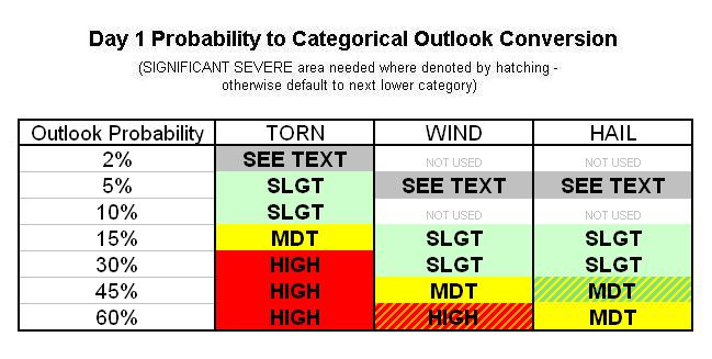
Three risk categories (SLGT, MDT, and HIGH) are used to symbolize the coverage and intensity of the expected severe weather threat. A SLGT risk implies well-organized severe thunderstorms are expected, but in small numbers and/or low coverage. Depending on the size of the area, approximately 5-25 reports of ¾ inch of larger hail, and/or 5-25 wind events, and/or 1-5 tornadoes would be possible. A MDT risk indicates a potential for a greater concentration of severe thunderstorms than the slight risk, and in most situations, greater magnitude of the severe weather. A HIGH risk area suggests a major severe weather outbreak is expected, with a high concentration of severe weather reports and an enhanced likelihood of extreme severe (i.e., violent tornadoes or very damaging convective wind events occurring across a large area). In a high risk, the potential exists for 20 or more tornadoes, some possibly F2 or stronger, or an extreme derecho potentially causing widespread wind damage and higher end wind gusts (80+ mph) that may result in structural damage. A SEE TEXT label will be used for areas where a 5% probability of severe is forecast, but the coverage or intensity is not expected to be sufficient for a slight risk.
These outlook categories are issued when organized convection with tornadoes, and/or large hail and/or damaging winds are expected. Examples of organized convection include supercells, squall lines, and multicell thunderstorm complexes. Pulse type thunderstorms, consisting primarily of solitary brief severe updrafts (often found in weakly sheared environments) are not considered organized. Isolated severe storms with marginal intensities or short durations of severe will likely not be included in a risk area.
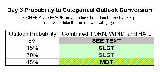
The slight, moderate and high categories are dependent on the probabilities used to determine the severe threat. The following Table shows the conversion from probabilities to the appropriate categorical outlook.
Note: A 5% probability for only a tornado threat (mainly associated with tropical systems) can be issued as a SLGT RISK.

Page last modified: February 14, 2006