
|
|
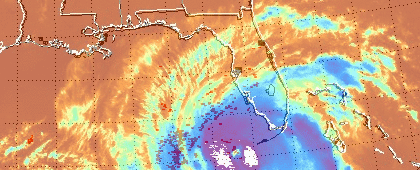
REAL DECISIONS FROM VIRTUAL WORLDSAnalysis and Simulation:Laboratory Teams Lend High-Tech Skills to Hurricane Rita Planning and ResponseLos Alamos scientists assisted in the developing Hurricane Rita situation, both in the air and in the realm of virtual reality. On-scene in the Gulf Coast area, Laboratory spectroscopic equipment was airborne on the EPA's ASPECT plane, which was based out of San Antonio, while Laboratory critical infrastructure modeling teams of Decision Applications (D) Division were hard at work. ASPECTThe ASPECT plane, an airborne toxin-detection platform operated by Los Alamos and the Environmental Protection Agency, was deployed to the southeast Texas coast where the hurricane made landfall on Friday. The ASPECT team scanned for potentially toxic chemical plumes from line or tank leaks, breaks and explosions:
See also: Flying Lab Uses High Tech System For Rescuers' Safety, ITnews.com.au INFRASTRUCTURE MODELINGPrior to Hurricane Rita's landfall, LANL teams were activated to provide impact predictions for the hurricane. The Lab teams work for both the Department of Homeland Security's National Infrastructure Simulation and Analysis Center (NISAC) and Critical Infrastructure Protection Decision Support System (CIP/DSS) plus the Department of Energy's Office of Energy Assurance (OEA). The Laboratory maintains technical modeling and simulation teams to assist both government organizations with detailed computer models of vulnerable power lines and stations, flooding effects on power systems and more. Decision makers, provided with Laboratory reports, can have better data on which to base decisions about community evacuation, power shutoff and restoration and most importantly, deployment of aid in developing situations. Los Alamos scientists will provide ongoing analyses as the hurricane makes landfall and flooding and restoration in the hurricane's aftermath evolves. |
NEWSNuclear Detection Equipment Finds Unprecedented LIghtning Levels in Rita, Katrina
|
