Pollutants in the Environment
Emergency Response
Pollutants in the Environment
Serving Communities
Natural Resource Restoration

Information for:
Emergency Responders
Students and Teachers
Interested Public
Research Institutions
Other Agencies

Current News
Special Note
FAQs

Catalogs of:
Publications
Software & Data Sets
Web Portals
Links
Downloads
Image Galleries
Abandoned Vessels
Drift Card Studies

About OR&R
Contact Us
Advanced Search
Site Index
Privacy Policy
Document Accessibility

Pollutants in the EnvironmentHome | Image Galleries | Pollutants in the Environment

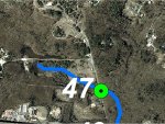
Mill Creek GPS Location 47

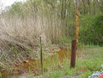
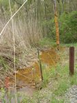
Location 47 is where an unpaved track leading to the Maryland Sand Gravel and Stone Superfund site, crosses over the south tributary of Mill Creek.  The creek water is stained a bright orange color at this location and phragmites are abundant in and adjacent to the creek.  The creek is only 1 to 2 m (3 to 5 feet) wide and a few inches deep, without discernable banks.  This area may be poor fish habitat due to degraded water quality, lack of suitable habitat, and insufficient flow.

Click on an image below to see the full image.

Location 47 - Aerial View

Location 47 - Aerial View
(11.30.99, Mill Creek)

Location 47 - Maryland Sand & Gravel

Location 47 - Maryland Sand & Gravel
(11.30.99, Mill Creek)

Location 47 - Iron-stained discharge from Maryland Sand & Gravel treatment system

Location 47 - Iron-stained discharge from Maryland Sand & Gravel treatment system (1 of 2)
(11.30.99, Mill Creek)

Location 47 - Iron-stained discharge from Maryland Sand & Gravel treatment system

Location 47 - Iron-stained discharge from Maryland Sand & Gravel treatment system (2 of 2)
(11.30.99, Mill Creek)

Related Pages on Our Site
NOAA logo